
Latest recommendations

| Id | Title | Authors | Abstract | Picture▼ | Thematic fields | Recommender | Reviewers | Submission date | |
|---|---|---|---|---|---|---|---|---|---|
03 Feb 2024
Digital surface models of crops used in archaeological feature detection – a case study of Late Neolithic site Tomašanci-Dubrava in Eastern CroatiaWhat lies on top lies also beneath? Connecting crop surface modelling to buried archaeology mapping.Recommended by Markos Katsianis based on reviews by Ian Moffat and Geert Verhoeven based on reviews by Ian Moffat and Geert Verhoeven
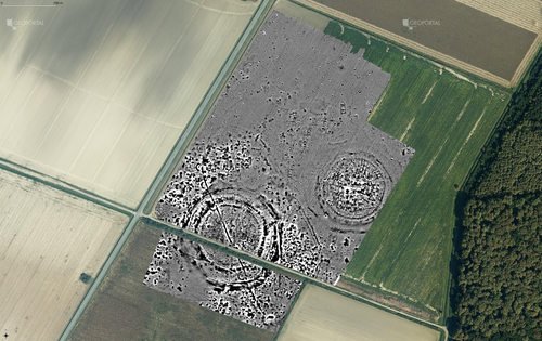
This paper (Sosic et al. 2024) explores the Neolithic landscape of the Sopot culture in Đakovština, Eastern Slavonija, revealing a network of settlements through a multi-faceted approach that combines aerial archaeology, magnetometry, excavation, and field survey. This strategy facilitates scalable research tailored to the particularities of each site and allows for improved representations of buried archaeology with minimal intrusion. Using the site of Tomašanci-Dubrava as an example of the overall approach, the study further explores the use of drone imagery for 3D surface modeling, revealing a consistent correlation between crop surface elevation during full plant growth and ground terrain after ploughing, attributed to subsurface archaeological features. Results are correlated with magnetic survey and test-pitting data to validate the micro-topography and clarify the relationship between different subsurface structures. The results obtained are presented in a comprehensive way, including their source data, and are contextualized in relation to conventional cropmark detection approaches and expectations. I found this aspect very interesting, since the crop surface and terrain models contradict typical or textbook examples of cropmark detection, where the vegetation is projected to appear higher in ditches and lower in areas with buried archaeology (Renfrew & Bahn 2016, 82). Regardless, the findings suggest the potential for broader applications of crop surface or canopy height modelling in landscape wide surveys, utilizing ALS data or aerial photographs. It seems then that the authors make a valid argument for a layered approach in landscape-based site detection, where aerial imagery can be used to accurately map the topography of areas of interest, which can then be further examined at site scale using more demanding methods, such as geophysical survey and excavation. This scalability enhances the research's relevance in broader archaeological and geographical contexts and renders it a useful example in site detection and landscape-scale mapping. References Renfrew, C. and Bahn, P. (2016). Archaeology: theories, methods and practice. Thames and Hudson. Sosic Klindzic, R., Vuković, M., Kalafatić, H. and Šiljeg, B. (2024). Digital surface models of crops used in archaeological feature detection – a case study of Late Neolithic site Tomašanci-Dubrava in Eastern Croatia, Zenodo, 7970703, ver. 4 peer-reviewed and recommended by Peer Community in Archaeology. https://doi.org/10.5281/zenodo.7970703 | Digital surface models of crops used in archaeological feature detection – a case study of Late Neolithic site Tomašanci-Dubrava in Eastern Croatia | Sosic Klindzic Rajna; Vuković Miroslav; Kalafatić Hrvoje; Šiljeg Bartul | <p>This paper presents the results of a study on the neolithic landscape of the Sopot culture in the area of Đakovština in Eastern Slavonija. A vast network of settlements was uncovered using aerial archaeology, which was further confirmed and chr... | | Landscape archaeology, Neolithic, Remote sensing, Spatial analysis | Markos Katsianis | 2023-09-01 12:57:04 | ||
05 Jun 2023

SEAHORS: Spatial Exploration of ArcHaeological Objects in R ShinyAnalyzing piece-plotted artifacts just got simpler: A good solution to the wrong problem?Recommended by Reuven Yeshurun based on reviews by Frédéric Santos, Jacqueline Meier and Maayan LevPaleolithic archaeologists habitually measure 3-coordinate data for artifacts in their excavations. This was first done manually, and in the last three decades it is usually performed by a total station and associated hardware. While the field recording procedure is quite straightforward, visualizing and analyzing the data are not, often requiring specialized proprietary software or coding expertise. Here, Royer and colleagues (2023) present the SEAHORS application, an elegant solution for the post-excavation analysis of artifact coordinate data that seems to be instantly useful for numerous archaeologists. SEAHORS allows one to import and organize field data (Cartesian coordinates and point description), which often comes in a variety of formats, and to create various density and distribution plots. It is specifically adapted to the needs of archaeologists, is free and accessible, and much simpler to use than many commercial programs. The authors further demonstrate the use of the application in the post-excavation analysis of the Cassenade Paleolithic site (see also Discamps et al., 2019). While in no way detracting from my appreciation of Royer et al.’s (2023) work, I would like to play the devil’s advocate by asking whether, in the majority of cases, field recording of artifacts in three coordinates is warranted. Royer et al. (2023) regard piece plotting as “…indispensable to propose reliable spatial planimetrical and stratigraphical interpretations” but this assertion does not hold in all (or most) cases, where careful stratigraphic excavation employing thin volumetric units would do just as well. Moreover, piece-plotting has some serious drawbacks. The recording often slows excavations considerably, beyond what is needed for carefully exposing and documenting the artifacts in their contexts, resulting in smaller horizontal and vertical exposures (e.g., Gilead, 2002). This typically hinders a fuller stratigraphic and contextual understanding of the excavated levels and features. Even worse, the method almost always creates a biased sample of “coordinated artifacts”, in which the most important items for understanding spatial patterns and site-formation processes – the small ones – are underrepresented. Some projects run the danger of treating the coordinated artifacts as bearing more significance than the sieve-recovered items, preferentially studying the former with no real justification. Finally, the coordinated items often go unassigned to a volumetric unit, effectively disconnecting them from other types of data found in the same depositional contexts. The advantages of piece-plotting may, in some cases, offset the disadvantages. But what I find missing in the general discourse (certainly not in the recommended preprint) is the “theory” behind the seemingly technical act of 3-coordinate recording (Yeshurun, 2022). Being in effect a form of sampling, this practice needs a rethink about where and how to be applied; what depositional contexts justify it, and what the goals are. These questions should determine if all “visible” artifacts are plotted, or just an explicitly defined sample of them (e.g., elongated items above a certain length threshold, which should be more reliable for fabric analysis), or whether the circumstances do not actually justify it. In the latter case, researchers sometimes opt for using “virtual coordinates” within in each spatial unit (typically 0.5x0.5 m), essentially replicating the data that is generated by “real” coordinates and integrating the sieve-recovered items as well. In either case, Royer et al.’s (2023) solution for plotting and visualizing labeled points within intra-site space would indeed be an important addition to the archaeologists’ tool kits.
References cited Discamps, E., Bachellerie, F., Baillet, M. and Sitzia, L. (2019). The use of spatial taphonomy for interpreting Pleistocene palimpsests: an interdisciplinary approach to the Châtelperronian and carnivore occupations at Cassenade (Dordogne, France). Paleoanthropology 2019, 362–388. https://doi.org/10.4207/PA.2019.ART136 Gilead, I. (2002). Too many notes? Virtual recording of artifacts provenance. In: Niccolucci, F. (Ed.). Virtual Archaeology: Proceedings of the VAST Euroconference, Arezzo 24–25 November 2000. BAR International Series 1075, Archaeopress, Oxford, pp. 41–44. Royer, A., Discamps, E., Plutniak, S. and Thomas, M. (2023). SEAHORS: Spatial Exploration of ArcHaeological Objects in R Shiny Zenodo, 7957154, ver. 2 peer-reviewed and recommended by Peer Community in Archaeology. https://doi.org/10.5281/zenodo.7929462 Yeshurun, R. (2022). Intra-site analysis of repeatedly occupied camps: Sacrificing “resolution” to get the story. In: Clark A.E., Gingerich J.A.M. (Eds.). Intrasite Spatial Analysis of Mobile and Semisedentary Peoples: Analytical Approaches to Reconstructing Occupation History. University of Utah Press, pp. 27–35.
| SEAHORS: Spatial Exploration of ArcHaeological Objects in R Shiny | ROYER, Aurélien, DISCAMPS, Emmanuel, PLUTNIAK, Sébastien, THOMAS, Marc | <p style="text-align: justify;">This paper presents SEAHORS, an R shiny application available as an R package, dedicated to the intra-site spatial analysis of piece-plotted archaeological remains. This open-source script generates 2D and 3D scatte... | | Computational archaeology, Spatial analysis, Theoretical archaeology | Reuven Yeshurun | 2023-02-24 16:01:44 | ||
29 Jan 2024
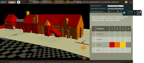
Visual encoding of a 3D virtual reconstruction's scientific justification: feedback from a proof-of-concept research3D Models, Knowledge and Visualization: a prototype for 3D virtual models according to plausible criteriaRecommended by Daniel Carvalho based on reviews by Robert Bischoff and Louise TharandtThe construction of 3D realities is deeply embedded in archaeological practices. From sites to artifacts, archaeology has dedicated itself to creating digital copies for the most varied purposes. The paper “Visual encoding of a 3D virtual reconstruction's 3 scientific justification: feedback from a proof-of-concept research” (Jean-Yves et al 2024) represents an advance, in the sense that it does not just deal with a three-dimensional theory for archaeological practice, but rather offers proposals regarding the epistemic component, how it is possible to represent knowledge through the workflow of 3D virtual reconstructions themselves. The authors aim to unite three main axes - knowledge modeling, visual encoding and 3D content reuse - (Jean-Yves et al 2024: 2), which, for all intents and purposes, form the basis of this article. With regard to the first aspect, this work questions how it is possible to transmit the knowledge we want to a 3D model and how we can optimize this epistemic component. A methodology based on plausibility criteria is offered, which, for the archaeological field, offers relevant space for reflection. Given our inability to fully understand the object or site that is the subject of the 3D representation, whether in space or time, building a method based on probabilistic categories is probably one of the most realistic approaches to the realities of the past. Thus, establishing a plausibility criterion allows the user to question the knowledge that is transmitted through the representation, and can corroborate or refute it in future situations. This is because the role of reusing these models is of great interest to the authors, a perfectly justifiable sentiment, as it encourages a critical view of scientific practices. Visual encoding is, in terms of its conjunction with knowledge practices, a key element. The notion of simplicity under Maeda's (2006) design principles not only represents a way of thinking that favors operability, but also a user-friendly design in the prototype that the authors have created. This is also visible when it comes to the reuse of parts of the models, in a chronological logic: adapting the models based on architectural elements that can be removed or molded is a testament to intelligent design, whereby instead of redoing models in their entirety, they are partially used for other purposes. All these factors come together in the final prototype, a web application that combines relational databases (RDBMS) with a data mapper (MassiveJS), using the PHP programming language. The example used is the Marmoutier Abbey hostelry, a centuries-old building which, according to the sources presented, has evolved architecturally over several centuries ((Jean-Yves et al 2024: 8). These states of the building are represented visually through architectural elements based on their existence, location, shape and size, always in terms of what is presented as being plausible. This allows not only the creation of a matrix in which various categories are related to various architectural elements, but also a visual aid, through a chromatic spectrum, of the plausibility that the authors are aiming for. In short, this is an article that seeks to rethink the degree of knowledge we can obtain through 3D visualizations and that does not take models as static, but rather realities that must be explored, recycled and reinterpreted in the light of different data, users and future research. For this reason, it is a work of great relevance to theoretical advances in 3D modeling adapted to archaeology.
References Blaise, J.-Y., Dudek, I., Bergerot, L. and Gaël, S. (2024). Visual encoding of a 3D virtual reconstruction's scientific justification: feedback from a proof-of-concept research, Zenodo, 7983163, ver. 3 peer-reviewed and recommended by Peer Community in Archaeology. https://doi.org/10.5281/zenodo.10496540 John Maeda. (2006). The Laws of Simplicity. MIT Press, Cambridge, MA, USA. | Visual encoding of a 3D virtual reconstruction's scientific justification: feedback from a proof-of-concept research | J.Y Blaise, I.Dudek, L.Bergerot, G.Simon | <p> 3D virtual reconstructions have become over the last decades a classical mean to communicate about analysts’ visions concerning past stages of development of an edifice or a site. However, they still today remain quite often a one-s... | | Computational archaeology, Spatial analysis | Daniel Carvalho | 2023-05-30 00:43:03 | ||
12 Apr 2024
Survey Planning, Allocation, Costing and Evaluation (SPACE) Project: Developing a Tool to Help Archaeologists Conduct More Effective SurveysA new tool to increase the robustness of archaeological field surveyRecommended by Jitte Waagen based on reviews by Philip Verhagen and Tymon de Haas
This well-written and interesting paper ‘Survey Planning, Allocation, Costing and Evaluation (SPACE) Project: Developing a Tool to Help Archaeologists Conduct More Effective Surveys’ deals with the development of a ‘modular, accessible, and simple web-based platform for survey planning and quality assurance’ in the area of pedestrian field survey methods (Banning et al. 2024). Although there have been excellent treatments of statistics in archaeological field survey (among which various by the first author: Banning 2020, 2021), and there is continuous methodological debate on platforms such as the International Mediterranean Survey Workshop (IMSW), in papers dealing with the current development and state of the field (Knodell et al. 2023), good practices (Attema et al. 2020) or the merits of a quantifying approach to archaeological densities (cf. de Haas et al. 2023), this paper rightfully addresses the lack of rigorous statistical approaches in archaeological field survey. As argued by several scholars such as Orton (2000), this mainly appears the result of lack of knowledge/familiarity/resources to bring in the required expertise etc. with the application of seemingly intricate statistics (cf. Waagen 2022). In this context this paper presents a welcome contribution to the feasibility of a robust archaeological field survey design. The SPACE application, under development by the authors, is introduced in this paper. It is a software tool that aims to provide different modules to assist archaeologists to make calculations for sample size, coverage, stratification, etc. under the conditions of survey goals and available resources. In the end, the goal is to ensure archaeological field surveys will attain their objectives effectively and permit more confidence in the eventual outcomes. The module concerning Sweep Widths, an issue introduced by the main author in 2006 (Banning 2006) is finished; the sweep width assessment is a methodology to calibrate one’s survey project for artefact types, landscape, visibility and person-bound performance, eventually increasing the quality (comparability) of the collected samples. This is by now a well-known calibration technique, yet little used, so this effort to make that more accessible is certainly laudable. An excellent idea, and another aim of this project, is indeed to build up a database with calibration data, so applying sweep-width corrections will become easier accessible to practitioners who lack time to set up calibration exercises. It will be very interesting to have a closer look at the eventual platform and to see if, and how, it will be adapted by the larger archaeological field survey community, both from an academic research perspective as from a heritage management point of view. I happily recommend this paper and all debate relating to it, including the excellent peer reviews of the manuscript by Philip Verhagen and Tymon de Haas (available as part of this PCI recommendation procedure), to any practitioner of archaeological field survey. References Attema, P., Bintliff, J., Van Leusen, P.M., Bes, P., de Haas, T., Donev, D., Jongman, W., Kaptijn, E., Mayoral, V., Menchelli, S., Pasquinucci, M., Rosen, S., García Sánchez, J., Luis Gutierrez Soler, L., Stone, D., Tol, G., Vermeulen, F., and Vionis. A. 2020. “A guide to good practice in Mediterranean surface survey projects”, Journal of Greek Archaeology 5, 1–62. https://doi.org/10.32028/9781789697926-2 Banning, E.B., Alicia L. Hawkins, S.T. Stewart, Sweep widths and the detection of artifacts in archaeological survey, Journal of Archaeological Science, Volume 38, Issue 12, 2011, Pages 3447-3458. https://doi.org/10.1016/j.jas.2011.08.007 Banning, E.B. 2020. Spatial Sampling. In: Gillings, M., Hacıgüzeller, P., Lock, G. (eds.) Archaeological Spatial Analysis. A Methodological Guide. Routledge. Banning, E.B. 2021. Sampled to Death? The Rise and Fall of Probability Sampling in Archaeology. American Antiquity, 86(1), 43-60. https://doi.org/10.1017/aaq.2020.39 Banning, E. B. Steven Edwards, & Isaac Ullah. (2024). Survey Planning, Allocation, Costing and Evaluation (SPACE) Project: Developing a Tool to Help Archaeologists Conduct More Effective Surveys. Zenodo, 8072178, ver. 9 peer-reviewed and recommended by Peer Community in Archaeology. https://doi.org/10.5281/zenodo.8072178 Knodell, A.R., Wilkinson, T.C., Leppard, T.P. et al. 2023. Survey Archaeology in the Mediterranean World: Regional Traditions and Contributions to Long-Term History. J Archaeol Res 31, 263–329 (2023). https://doi.org/10.1007/s10814-022-09175-7 Orton, C. 2000. Sampling in Archaeology. Cambridge University Press. https://doi.org/10.1017/CBO9781139163996 Waagen, J. 2022. Sampling past landscapes. Methodological inquiries into the bias problems of recording archaeological surface assemblages. PhD-Thesis. https://hdl.handle.net/11245.1/e9cb922c-c7e4-40a1-b648-7b8065c46880 de Haas, T., Leppard, T. P., Waagen, J., & Wilkinson, T. (2023). Myopic Misunderstandings? A Reply to Meyer (JMA 35(2), 2022). Journal of Mediterranean Archaeology, 36(1), 127-137. https://doi.org/10.1558/jma.27148 | Survey Planning, Allocation, Costing and Evaluation (SPACE) Project: Developing a Tool to Help Archaeologists Conduct More Effective Surveys | E. B. Banning, Steven Edwards, and Isaac Ullah | <p>Designing an effective archaeological survey can be complicated and confidence that it was effective requires post-survey evaluation. The goal of SPACE is to develop software to facilitate survey designers’ decisions and partially automate tool... | | Computational archaeology, Landscape archaeology | Jitte Waagen | 2023-06-28 13:42:28 | ||
02 Apr 2024
Similarity Network Fusion: Understanding Patterns and their Spatial Significance in Archaeological DatasetsA different approach to similarity networks in Archaeology - Similarity Network FusionRecommended by Joel Santos based on reviews by Matthew Peeples and 1 anonymous reviewerThis is a fascinating paper for anyone interested in network analysis or the chronology and cultures of the case study, namely the Late prehistoric burial sites in Dorset, for which the author’s approach allowed a new perspective over an already deeply studied area [1]. This paper's implementation of Similarity Network Fusion (SNF) is noteworthy. This method is typically utilized within genetic research but has yet to be employed in Archaeology. SNF has the potential to benefit Archaeology due to its unique capabilities and approach significantly. The author exhibits a deep and thorough understanding of previous investigations concerning material and similarity networks while emphasizing the innovative nature of this particular study. The SNF approach intends to improve a lack of the most used (in Archaeology) similarity coefficient, the Brainerd-Robinson, in certain situations, mainly in heterogenous and noisy datasets containing a small number of samples but a large number of measurements, scale differences, and collection biases, among other things. The SNF technique, demonstrated in the case study, effectively incorporates various similarity networks derived from different datatypes into one network. As shown during the Dorset case study, the SNF application has a great application in archaeology, even in already available data, allowing us to go further and bring new visions to the existing interpretations. As stated by the author, SNF shows its potential for other applications and fields in archaeology coping with similar datasets, such as archaeobotany or archaeozoology, and seems to complement different multivariate statistical approaches, such as correspondence or cluster analysis. This paper has been subject to two excellent revisions, which the author mostly accepted. One of the revisions was more technical, improving the article in the metadata part, data availability and clarification, etc. Although the second revision was more conceptual and gave some excellent technical inputs, it focused more on complementary aspects that will allow the paper to reach a wider audience. I vividly recommend its publication. References [1] Geitlinger, T. (2024). Similarity Network Fusion: Understanding Patterns and their Spatial Significance in Archaeological Datasets. Zenodo, 7998239, ver. 3 peer-reviewed and recommended by Peer Community in Archaeology. https://doi.org/10.5281/zenodo.7998239
| Similarity Network Fusion: Understanding Patterns and their Spatial Significance in Archaeological Datasets | Timo Geitlinger | <p>Since its earliest application in the 1970s, network analysis has become increasingly popular in both theoretical and GIS-based archaeology. Yet, applications of material networks remained relatively restricted. This paper describes a specific ... | | Computational archaeology, Protohistory | Joel Santos | 2023-06-02 16:51:19 | ||
03 Nov 2023
The Dynamic Collections – a 3D Web Platform of Archaeological Artefacts designed for Data Reuse and Deep InteractionA comparative teaching and learning tool for 3D data: Dynamic CollectionsRecommended by Sebastian Hageneuer based on reviews by Alex Brandsen and Louise Tharandt
The paper (Callieri, M. et al. 2023) describes the “Dynamic Collections” project, an online platform initially created to showcase digital archaeological collections of Lund University. During a phase of testing by department members, new functionalities and artefacts were added resulting in an interactive platform adapted to university-level teaching and learning. The paper introduces into the topic and related works after which it starts to explain the project itself. The idea is to resemble the possibilities of interaction of non-digital collections in an online platform. Besides the objects themselves, the online platform offers annotations, measurement and other interactive tools based on the already known 3DHOP framework. With the possibility to create custom online collections a collaborative working/teaching environment can be created. The already wide-spread use of the 3DHOP framework enabled the authors to develop some functionalities that could be used in the “Dynamic Collections” project. Also, current and future plans of the project are discussed and will include multiple 3D models for one object or permanent identifiers, which are both important additions to the system. The paper then continues to explain some of its further planned improvements, like comparisons and support for teaching, which will make the tool an important asset for future university-level education. The paper in general is well-written and informative and introduces into the interactive tool, that is already available and working. It is very positive, that the authors rely on up-to-date methodologies in creating 3D online repositories and are in fact improving them by testing the tool in a teaching environment. They mention several times the alignment with upcoming EU efforts related to the European Collaborative Cloud for Cultural Heritage (ECCCH), which is anticipatory and far-sighted and adds to the longevity of the project. Comments of the reviewers were reasonably implemented and led to a clearer and more concise paper. I am very confident that this tool will find good use in heritage research and presentation as well as in university-level teaching and learning. Although the authors never answer the introductory question explicitly (What characteristics should a virtual environment have in order to trigger dynamic interaction?), the paper gives the implicit answer by showing what the "Dynamic Collections" project has achieved and is able to achieve in the future. BibliographyCallieri, M., Berggren, Å., Dell'Unto, N., Derudas, P., Dininno, D., Ekengren, F., and Naponiello, G. (2023). The Dynamic Collections – a 3D Web Platform of Archaeological Artefacts designed for Data Reuse and Deep Interaction, Zenodo, 10067103, ver. 3 peer-reviewed and recommended by Peer Community in Archaeology. https://doi.org/10.5281/zenodo.10067103 | The Dynamic Collections – a 3D Web Platform of Archaeological Artefacts designed for Data Reuse and Deep Interaction | Marco Callieri, Åsa Berggren, Nicolò Dell’Unto, Paola Derudas, Domenica Dininno, Fredrik Ekengren, Giuseppe Naponiello | <p>The Dynamic Collections project is an ongoing initiative pursued by the Visual Computing Lab ISTI-CNR in Italy and the Lund University Digital Archaeology Laboratory-DARKLab, Sweden. The aim of this project is to explore the possibilities offer... | | Archaeometry, Computational archaeology | Sebastian Hageneuer | 2023-08-31 15:05:32 | ||
24 Jan 2024
Social Network Analysis, Community Detection Algorithms, and Neighbourhood Identification in PompeiiA Valuable Contribution to Archaeological Network Research: A Case Study of PompeiiRecommended by David Laguna-Palma based on reviews by Matthew Peeples, Isaac Ullah and Philip Verhagen
The paper entitled 'Social Network Analysis, Community Detection Algorithms, and Neighbourhood Identification in Pompeii' [1] presents a significant contribution to the field of archaeological network research, particularly in the challenging task of identifying urban neighborhoods within the context of Pompeii. This study focuses on the relational dynamics within urban neighborhoods and examines their indistinct boundaries through advanced analytical methods. The methodology employed provides a comprehensive analysis of community detection, including the Louvain and Leiden algorithms, and introduces a novel Convex Hull of Admissible Modularity Partitions (CHAMP) algorithm. The incorporation of a network approach into this domain is both innovative and timely. The potential impact of this research is substantial, offering new perspectives and analytical tools. This opens new avenues for understanding social structures in ancient urban settings, which can be applied to other archaeological contexts beyond Pompeii. Moreover, the manuscript is not only methodologically solid but also well-written and structured, making complex concepts accessible to a broad audience. In conclusion, this study represents a valuable contribution to the field of archaeology, particularly for archaeological network research. Their results not only enhance our knowledge of Pompeii but also provide a robust framework for future studies in similar historical contexts. Therefore, this publication advances our understanding of social dynamics in historical urban environments. The rigorous analysis, combined with the innovative application of network algorithms, makes this study a noteworthy addition to the existing body of network science literature. It is recommended for a wide range of scholars interested in the intersection of archaeology, history, and network science. Reference [1] Notarian, Matthew. 2024. Social Network Analysis, Community Detection Algorithms, and Neighbourhood Identification in Pompeii. https://doi.org/10.5281/zenodo.8305968 | Social Network Analysis, Community Detection Algorithms, and Neighbourhood Identification in Pompeii | Notarian, Matthew | <p>The definition and identification of urban neighbourhoods in archaeological contexts remain complex and problematic, both theoretically and empirically. As constructs with both social and spatial characteristics, their detection through materia... | | Antiquity, Classic, Computational archaeology, Mediterranean | David Laguna-Palma | 2023-08-31 19:28:35 | ||
28 May 2020

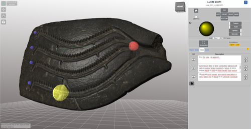
TIPZOO: a Touchscreen Interface for Palaeolithic Zooarchaeology. Towards making data entry and analysis easier, faster, and more reliableA new software to improve standardization and quality of data in zooarchaeologyRecommended by Florent Rivals based on reviews by Delphine Vettese and Argant Thierry
Standardization and quality of data collection are identified as challenges for the future in zooarchaeology [1]. These issues were already identified in the early 1970s when the International Council for Archaeozoology (ICAZ) recommended to “standardize measurements and data in publications”. In the recent years, there is strong recommendations by publishers and grant to follow the FAIR Principle i.e. to “improve the findability, accessibility, interoperability, and reuse of digital assets” [2]. As zooarchaeologists, we should make our methods more clear and replicable by other researchers to produce comparable datasets. In this paper the authors make a significant step in proposing a tool to replace traditional data recording softwares. The problems related to data recording are clearly identified and discussed. All the features offered by TIPZOO allow to standardize the data, to reduce the errors when entering the data, to save time with auto-filling entries. The coding system used in TIPZOO is based on variables taken from the most used and updated literature in zooarchaeology. Its connections with various R packages allow to directly export the data and to transform the raw data to produce summary tables, graphs and basic statistics. Finally, the advantage of this tool is that it can be improved, debugged, or implemented at any time. TIPZOO provides a standardized system to compile and share large and consistent datasets that will allow comparison among assemblages at a large scale, and for this reason, I have recommended the work for PCI Archaeology. References [1] Steele, T.E. (2015). The contributions of animal bones from archaeological sites: the past and future of zooarchaeology. J. Archaeol. Sci. 56, 168–176. doi: 10.1016/j.jas.2015.02.036 | TIPZOO: a Touchscreen Interface for Palaeolithic Zooarchaeology. Towards making data entry and analysis easier, faster, and more reliable | Emmanuel Discamps | <p>Zooarchaeological studies of fossil bone collections are often conducted using simple spreadsheet programs for data recording and analysis. After quickly summarizing the limitations of such an approach, we present a new software solution, TIPZO... | | Spatial analysis, Taphonomy, Zooarchaeology | Florent Rivals | 2020-04-16 13:27:00 | ||
05 Jan 2024
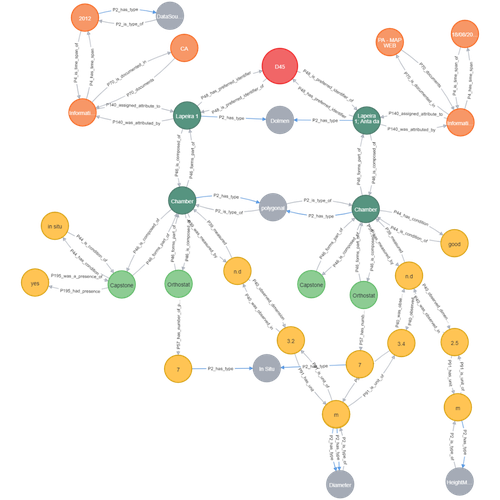
Transforming the CIDOC-CRM model into a megalithic monument property graphInformative description of a project implementing a CIDOC-CRM based native graph database for representing megalithic informationRecommended by Isto Huvila based on reviews by 2 anonymous reviewersThe paper “Transforming the CIDOC-CRM model into a megalithic monument property graph” describes an interesting endeavour of developing and implementing a CIDOC-CRM based knowledge graph using a native graph database (Neo4J) to represent megalithic information (Câmara et al. 2023). While there are earlier examples of using native graph databases and CIDOC-CRM in diverse heritage contexts, the present paper is useful addition to the literature as a detailed description of an implementation in the context of megalithic heritage. The paper provides a demonstration of a working implementation, and guidance for future projects. The described project is also documented to an extent that the paper will open up interesting opportunities to compare the approach to previous and forthcoming implementations. The same applies to the knowledge graph and use of CIDOC-CRM in the project. Readers interested in comparing available technologies and those who are developing their own knowledge graphs might have benefited of a more detailed description of the work in relation to the current state-of-the-art and what the use of a native graph database in the built-heritage contexts implies in practice for heritage documentation beyond that it is possible and it has potentially meaningful performance-related advantages. While also the reasons to rely on using plain CIDOC-CRM instead of extensions could have been discussed in more detail, the approach demonstrates how the plain CIDOC-CRM provides a good starting point to satisfy many heritage documentation needs. As a whole, the shortcomings relating to positioning the work to the state-of-the-art and reflecting and discussing design choices do not reduce the value of the paper as a valuable case description for those interested in the use of native graph databases and CIDOC-CRM in heritage documentation in general and the documentation of megalithic heritage in particular. ReferencesCâmara, A., de Almeida, A. and Oliveira, J. (2023). Transforming the CIDOC-CRM model into a megalithic monument property graph, Zenodo, 7981230, ver. 4 peer-reviewed and recommended by Peer Community in Archaeology. https://doi.org/10.5281/zenodo.7981230 | Transforming the CIDOC-CRM model into a megalithic monument property graph | Ariele Câmara, Ana de Almeida, João Oliveira | <p>This paper presents a method to store information about megalithic monuments' building components as graph nodes in a knowledge graph (KG). As a case study we analyse the dolmens from the region of Pavia (Portugal). To build the KG, information... | | Computational archaeology | Isto Huvila | 2023-05-29 13:46:49 | ||
12 Dec 2022
Can growth in captivity alter the calcaneal microanatomy of a wild ungulate?Mobility in pigs: A microanatomical perspectiveRecommended by Nimrod Marom based on reviews by Max Price and Ignacio A. Lazagabaster
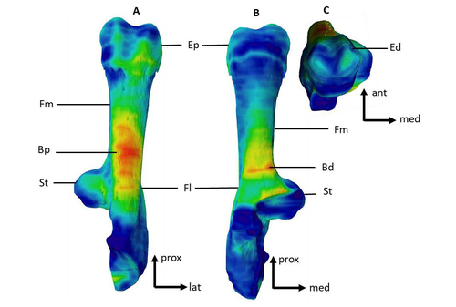
Pig domestication and husbandry involved complex processes of introduction, introgression, and feralization that challenge our understanding of human/suid interactions in ancient times. This challenge is a constant stimulus for the development of novel methods and techniques to illuminate aspects of early pig husbandry, such as human-induced changes in mobility. Using geometric morphometrics, Harbers et al. (2020) have shown that the calcaneus records a plastic response to reduced mobility and hence to human management. In the present study, Cottereau et al. (2022) explore the possibility that a similar plastic response to different mobility regimes can be observed in the microanatomy of the calcaneus using CT scans. Their research utilizes a sample of calcanei obtained from Mesolithic specimens, and also from recent suids kept in natural habitat, large pen, and stall. Their results suggest that bone microanatomy is more affected by population differences than by mobility patterns, as illustrated by the similarity between Mesolitic boar calcanei and their difference from recent, free wild boar.
References Cottereau R, Ortiz K, Locatelli Y, Houssaye A, Cucchi T (2022), bioRxiv, 504790, ver. 5 peer-reviewed and recommended by Peer Community in Archaeology. https://doi.org/10.1101/2022.08.22.504790 Harbers H, Neaux D, Ortiz K, Blanc B, Laurens F, Baly I, Callou C, Schafberg R, Haruda A, Lecompte F, Casabianca F, Studer J, Renaud S, Cornette R, Locatelli Y, Vigne J-D, Herrel A, Cucchi T (2020) The mark of captivity: plastic responses in the ankle bone of a wild ungulate (Sus scrofa). Royal Society Open Science, 7, 192039. https://doi.org/10.1098/rsos.192039
| Can growth in captivity alter the calcaneal microanatomy of a wild ungulate? | Romain Cottereau, Katia Ortiz, Yann Locatelli, Alexandra Houssaye*, Thomas Cucchi* | <p style="text-align: justify;">Reduced mobility associated with captivity induce changes in biomechanical stress on the skeleton of domesticated animals. Due to bone plasticity, the morphology and the internal structure of the bones can respond t... | | Neolithic, Zooarchaeology | Nimrod Marom | 2022-08-26 20:29:01 |


