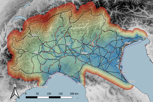


Studies of the economy of the Roman Empire have become increasingly interdisciplinary and nuanced in recent years, allowing the discipline to make great strides in data collection and importantly in the methods through which this increasing volume of data can be effectively and meaningfully analysed [see for example 1 and 2]. One of the key aspects of modelling the ancient economy is understanding movement and transport costs, and how these facilitated trade, communication and economic development. With archaeologists adopting more computational techniques and utilising GIS analysis beyond simply creating maps for simple visualisation, understanding and modelling the costs of traversing archaeological landscapes has become a much more fruitful avenue of research. Classical archaeologists are often slower to adopt these new computational techniques than others in the discipline. This is despite (or perhaps due to) the huge wealth of data available and the long period of time over which the Roman economy developed, thrived and evolved. This all means that the Roman Empire is a particularly useful proving ground for testing and perfecting new methodological developments, as well as being a particularly informative period of study for understanding ancient human behaviour more broadly. This paper by Page [3] then, is well placed and part of a much needed and growing trend of Roman archaeologists adopting these computational approaches in their research.
Page’s methodology builds upon De Soto’s earlier modelling of transport costs [4] and applies it in a new setting. This reflects an important practice which should be more widely adopted in archaeology. That of using existing, well documented methodologies in new contexts to offer wider comparisons. This allows existing methodologies to be perfected and tested more robustly without reinventing the wheel. Page does all this well, and not only builds upon De Soto’s work, but does so using a case study that is particularly interesting with convincing and significant results.
As Page highlights, Northern Italy is often thought of as relatively isolated in terms of economic exchange and transport, largely due to the distance from the sea and the barriers posed by the Alps and Apennines. However, in analysing this region, and not taking such presumptions for granted, Page quite convincingly shows that the waterways of the region played an important role in bringing down the cost of transport and allowed the region to be far more interconnected with the wider Roman world than previous studies have assumed.
This article is clearly a valuable and important contribution to our understanding of computational methods in archaeology as well as the economy and transport network of the Roman Empire. The article utilises innovative techniques to model transport in an area of the Roman Empire that is often overlooked, with the economic isolation of the area taken for granted. Having high quality research such as this specifically analysing the region using the most current methodologies is of great importance. Furthermore, developing and improving methodologies like this allow for different regions and case studies to be analysed and directly compared, in a way that more traditional analyses simply cannot do. As such, Page has demonstrated the importance of reanalysing traditional assumptions using the new data and analyses now available to archaeologists.
References
[1] Brughmans, T. and Wilson, A. (eds.) (2022). Simulating Roman Economies: Theories, Methods, and Computational Models. Oxford.
[2] Dodd, E.K. and Van Limbergen, D. (eds.) (2024). Methods in Ancient Wine Archaeology: Scientific Approaches in Roman Contexts. London ; New York.
[3] Page, J. (2024). Rivers vs. Roads? A route network model of transport infrastructure in Northern Italy during the Roman period, Zenodo, 7971399, ver. 3 peer-reviewed and recommended by Peer Community in Archaeology. https://doi.org/10.5281/zenodo.7971399
[4] De Soto P (2019). Network Analysis to Model and Analyse Roman Transport and Mobility. In: Finding the Limits of the Limes. Modelling Demography, Economy and Transport on the Edge of the Roman Empire. Ed. by Verhagen P, Joyce J, and Groenhuijzen M. Springer Open Access, pp. 271–90. https://doi.org/10.1007/978-3-030-04576-0_13
DOI or URL of the preprint: https://doi.org/10.5281/zenodo.7971400
Version of the preprint: 1
Dear PCI Archaeology,
In have now responded to the peer review for my article and uploaded a new version to Zenodo. To briefly summarise:
- More detail has been added on the sources and data used to create the network vectors, particularly the river network.
- Information on how gradient penalties were calculated has been added.
- The potential accuracy of routes has been commented on.
- More information on the origin of data for transport costs in the Roman world has been added.
- Text has been edited to make references to locations in the figures clearer.
- The DEM used in the analysis has been named.
I have uploaded a pdf that highlights changes in the text.
Best wishes,
James
This article is clearly a valuable and important contribution to our understanding of computational methods in archaeology as well as the economy and transport network of the Roman Empire.
Both reviews provided are comprehensive and stress the quality and importance of the research and conclusions outlined in the article. There are some suggestions for improving the article in the second review, but these are minor.
Please revise according to the suggestions of both reviewers.
This is a very interesting article that uses transport costs to understand the political and economic configuration of a territory in Northern Italy. The studied region has traditionally been identified as an isolated territory due to its geographical characteristics, being a mountainous area located relatively far from seaports.
Methodologically, the author uses tools already applied to the study of Roman transport, applying interesting innovations that have increased the complexity of the calculations. I especially highlight the inclusion of the cost in the exchange of goods between different means of transport.
As for the results, I think the author provides a new point of view to understand northern Italy with quantified data and a transport model that offers a new perspective on mobility and the economy of this region.
I would have liked to find in this article more references to the archaeological records that would support the proposals made by the author based on the digital model of transport costs. These data would offer the reader a better understanding of whether the historical-archaeological reality of this region supports the results of the article.
In summary, I find this article very interesting and necessary to continue exploring new approaches to quantify transport in antiquity. The author has increased the complexity of the methodology that had been applied up to now and has generated some unique results that offer a new historical perspective to northern Italy.
https://doi.org/10.24072/pci.archaeo.100336.rev11The main objective of the article is to reconstruct the Roman transport network of the northern Italian Po Valley and its encircling mountain ranges (the Apennines and the Alps) in order to analyse the degree of integration/isolation of the region with regards to the transport costs.
The author put a lot of effort into painstakingly digitising the transport network (composed of roads, fluvial, connections, canals, and sea lanes) and the network nodes in GIS, based on up-to-date published evidence. He then goes on to recreate the multi-modal transport network by assigning Pau de Soto's transport costs values and analysing the model using common GIS methods and toolboxes. The presentation of the data, methods, and results is concise and clear. The subsequent discussion and conclusion is likewise comprehensibly presented not omitting the main points revealed by the analysis.
There are however, several suggestions to the author on how to improve the manuscript:
1) What needs more explanations is the way how the system of waterways was recreated - is it based only on historical and archaeological evidence, or does it include some assumptions about the navigability of river in cases where we lack the evidence? As is demonstrated in the article the waterways are the most important modes of transport regarding the transport costs, so the inclusion or omission of waterways will greatly influence the results.
2) Is it possible to evaluate the accuracy of the road digitization? Meaning in what cases it was possible to digitize the road accurately and where not and discus how the accuracy of digitization might influence the network analysis (due to different road length and gradient)?
3) In connection to the roads I miss information about the Digital Elevation Model used to calculate the gradients. What I also miss is the description of the mechanism that translates the gradient into additional cost penalty.
4) Perhaps more space could be given to the discussion of the transport costs and why particularly de Soto's value were used.
5) Some sites that appear in the text could be added to the maps for better clarity (especially for people unacquainted with the region), such as sites on p. 5 l. 167, p. 6 l. 174 and l.176-177.
Overall, the article fits perfectly with contemporary interest in the transportation economy in the Roman period and constitutes an important contribution in that matter. Moreso, as it employs computational methods and tries to approach the topic empirically. Especially interesting is the discussion of the relative importance of the Adriatic and Ligurian ports which might stimulate further research into the matter.
https://doi.org/10.24072/pci.archaeo.100336.rev12