
MOFFAT Ian
- Archaeology, College of Humanities, Arts and Social Sciences, Flinders University, Adelaide, Australia
- Africa, Ancient Palaeolithic, Archaeometry, Asia, Europe, Geoarchaeology, Landscape archaeology, Mediterranean, Middle Palaeolithic, Neolithic, Oceania, Paleoenvironment, Remote sensing, Spatial analysis, Taphonomy, Upper Palaeolithic
- recommender
Recommendation: 1
Review: 1
Recommendation: 1
ARIADNEplus Visual Media Service 3D configurator: toward full guided publication of high-resolution 3D data
ARIADNEplus Visual Media Service 3D configurator: a new tool for the visual organisation of 3D datasets
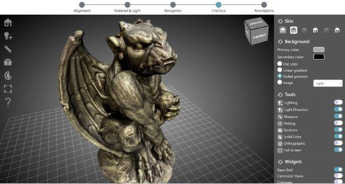
Recommended by Ian Moffat based on reviews by Sebastian Hageneuer, Vayia Panagiotidis, Erik Champion and Martina TrognitzThe manuscript "ARIADNEplus Visual Media Service 3D configurator: toward full guided publication of high-resolution 3D data" by Potenziani et al. [1] provides an excellent introduction to the Visual Media Service 3D Configurator. This is an exciting tool, focused on cultural heritage, that forms part of the Visual Media Service, a web-based platform for uploading a range of complex data sets, including high-resolution images, Reflectance Transformation Imaging images and 3D models and transforming them into an appropriate format for interation and visualisation on the web. The 3D Configurator Tool provides researchers with a wizard which assist with the presentation of 3D models.
This manuscript provides a history and context for the development of the Visual Media Service and previous related tools such as 3DHOP, Nexus and Relight/OpenLIME. It also provides detailed information about the functionality of the 3D Configurator, including the Alignment, Material & Light, Navigation, Interface and Annotation steps. The Discussion section provides information about applications and users of the Visual Media Service, current limitations and planned future developments.
Reviewers Hageneuer, Champion, Trognitz and Panagiotidis all provided important suggestions to the authors which have improved the clarity and scope of this manuscript. While this manscript does not present a case study using this tool, I recommend it to readers as a detailed and clear introduction to the Visual Media Service 3D configurator which may inspire them to use this for their own research.
References
[1] Potenziani, M., Ponchio, F., Callieri, M., and Cignoni, P. (2024). ARIADNEplus Visual Media Service 3D configurator: toward full guided publication of high-resolution 3D data. Zenodo, 8075050, ver. 5 peer-reviewed and recommended by Peer Community in Archaeology. https://doi.org/10.5281/zenodo.10894515
Review: 1
Digital surface models of crops used in archaeological feature detection – a case study of Late Neolithic site Tomašanci-Dubrava in Eastern Croatia
What lies on top lies also beneath? Connecting crop surface modelling to buried archaeology mapping.
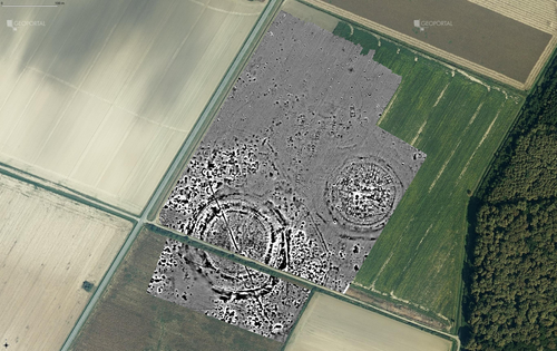
Recommended by Markos Katsianis based on reviews by Ian Moffat and Geert VerhoevenThis paper (Sosic et al. 2024) explores the Neolithic landscape of the Sopot culture in Đakovština, Eastern Slavonija, revealing a network of settlements through a multi-faceted approach that combines aerial archaeology, magnetometry, excavation, and field survey. This strategy facilitates scalable research tailored to the particularities of each site and allows for improved representations of buried archaeology with minimal intrusion.
Using the site of Tomašanci-Dubrava as an example of the overall approach, the study further explores the use of drone imagery for 3D surface modeling, revealing a consistent correlation between crop surface elevation during full plant growth and ground terrain after ploughing, attributed to subsurface archaeological features. Results are correlated with magnetic survey and test-pitting data to validate the micro-topography and clarify the relationship between different subsurface structures.
The results obtained are presented in a comprehensive way, including their source data, and are contextualized in relation to conventional cropmark detection approaches and expectations. I found this aspect very interesting, since the crop surface and terrain models contradict typical or textbook examples of cropmark detection, where the vegetation is projected to appear higher in ditches and lower in areas with buried archaeology (Renfrew & Bahn 2016, 82). Regardless, the findings suggest the potential for broader applications of crop surface or canopy height modelling in landscape wide surveys, utilizing ALS data or aerial photographs.
It seems then that the authors make a valid argument for a layered approach in landscape-based site detection, where aerial imagery can be used to accurately map the topography of areas of interest, which can then be further examined at site scale using more demanding methods, such as geophysical survey and excavation. This scalability enhances the research's relevance in broader archaeological and geographical contexts and renders it a useful example in site detection and landscape-scale mapping.
References
Renfrew, C. and Bahn, P. (2016). Archaeology: theories, methods and practice. Thames and Hudson.
Sosic Klindzic, R., Vuković, M., Kalafatić, H. and Šiljeg, B. (2024). Digital surface models of crops used in archaeological feature detection – a case study of Late Neolithic site Tomašanci-Dubrava in Eastern Croatia, Zenodo, 7970703, ver. 4 peer-reviewed and recommended by Peer Community in Archaeology. https://doi.org/10.5281/zenodo.7970703