Latest recommendations

| Id | Title | Authors | Abstract | Picture | Thematic fields | Recommender▲ | Reviewers | Submission date | |
|---|---|---|---|---|---|---|---|---|---|
14 Nov 2022
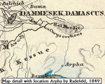
Raphana of the Decapolis and its successor Arpha - The search for an eminent Greco-Roman CityCross-comparison of classical sources, explorer and scientific reports and maps in the search of an ancient city: The example of Raphana of the DecapolisRecommended by Luc Doyon based on reviews by Rocco Palermo and Francesca Mazzilli based on reviews by Rocco Palermo and Francesca Mazzilli
Establishing the precise location of ancient cities constitutes a challenging task that requires the implementation of multi-disciplinary approaches. In his manuscript entitled “Raphana of the Decapolis and its successor Arpha: The search of an eminent Greco-Roman city”, Kleb (2022) proposes a convincing argument building on in-depth research of classical literary sources, literature review of explorer accounts and scientific publications from the 19th and 20th century as well as analysis of old and new maps, aerial photographs, and satellite images. This research report clearly emphasizes the importance of undertaking systematic interdisciplinary work on the topic to mitigate the uncertainties associated with the identification of Raphana, the Decapolis city first mentioned by Pliny the Elder. The Decapolis refers to a group of ten cities of Hellenistic traditions located on the eastern borders of the Roman Empire. This group of cities plays an important role in research that aims to contextualize the Judaean and Galilean history and to investigate urban centers in which different local and Greco-Roman influences met (Lichtenberger, 2021). While the location of most of the Decapolis cities is known and is (or was) subjected to systematic archaeological investigations (e.g., Eisenberg and Kowalewska, 2022; Makhadmeh et al., 2020; Shiyab et al., 2019), the location of others remain speculative. This is the case of Raphana for which the precise location remains difficult to establish owing in part to numerous name changes, limited information on the city structure, architecture, and size, etc. The research presented by Kleb (2022) has some merits, which is emphasized here, although the report is presented in an unusual format compared to traditional scientific articles, i.e., introduction, research background, methodology, results, and discussion. First, the extensive review of classical works allows the reader to gain a historical perspective on the change of names from Raepta/Raphana to Arpha/Arefa. The author argues these different names likely refer to a single location. Second, the author combs through an impressive literature from the 19th and 20th century and emphasize how some assumptions by explorers who visited the region were introduced in the scientific literature and remained unchallenged. Finally, the author gathers a remarkable quantity of old and new maps of the Golan, el-Ledja and Hauran regions and compare them with multiple lines of evidence to hypothesize that the location of Raphana may lie near Ar-Rafi’ah, also known as Bir Qassab, in the Ard el Fanah plain, a conclusion that now requires to be tested through fieldwork investigations. References Kleb, J. (2022) Raphana of the Decapolis and its successor Arpha - The search for an eminent Greco-Roman City. Figshare, 20550021, ver. 4 peer-reviewed and recommended by Peer Community in Archaeology. https://doi.org/10.6084/m9.figshare.20550021 Eisenberg, M. and Kowalewska, A. (2022). Funerary podia of Hippos of the Decapolis and the phenomenon in the Roman world. J. Roman Archaeol. 35, 107–138. https://doi.org/10.1017/S1047759421000465 Lichtenberger, A. (2021). The Decapolis, in: A Companion to the Hellenistic and Roman Near East. John Wiley & Sons, Ltd, pp. 213–222. https://doi.org/10.1002/9781119037354.ch18 Makhadmeh, A., Al-Badarneh, M., Rawashdeh, A. and Al-Shorman, A. (2020). Evaluating the carrying capacity at the archaeological site of Jerash (Gerasa) using mathematical GIS modeling. Egypt. J. Remote Sens. Space Sci. 23, 159–165. https://doi.org/10.1016/j.ejrs.2018.09.002 Shiyab, A., Al-Shorman, A., Turshan, N., Tarboush, M., Alawneh, F. and Rahabneh, A. (2019). Investigation of late Roman pottery from Gadara of the Decapolis, Jordan using multi-methodic approach. J. Archaeol. Sci. Rep. 25, 100–115. https://doi.org/10.1016/j.jasrep.2019.04.003 | Raphana of the Decapolis and its successor Arpha - The search for an eminent Greco-Roman City | Jens Kleb | <p style="text-align: justify;">This research paper presents a detailed analysis of ancient literature and archaeological and geographical research until the present day for an important ancient location in the southern part of Syria. This one had... | | Landscape archaeology, Mediterranean, Spatial analysis, Theoretical archaeology | Luc Doyon | 2021-12-30 13:54:32 | ||
12 Feb 2024
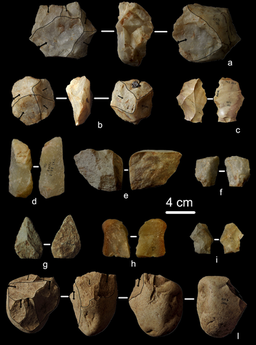
First evidence of a Palaeolithic occupation of the Po plain in Piedmont: the case of Trino (north-western Italy)Not Simply the Surface: Manifesting Meaning in What Lies Above.Recommended by Marcel Kornfeld based on reviews by Lawrence Todd, Jason LaBelle and 2 anonymous reviewersThe archaeological record comes in many forms. Some, such as buried sites from volcanic eruptions or other abrupt sedimentary phenomena are perhaps the only ones that leave relatively clean snapshots of moments in the past. And even in those cases time is compressed. Much, if not all other archaeological record is a messy affair. Things, whatever those things may be, artifacts or construction works (i.e., features), moved, modified, destroyed, warped and in a myriad of ways modified from their behavioral contexts. Do we at some point say the record is worthless? Not worth the effort or continuing investigation. Perhaps sometimes this may be justified, but as Daffara and colleagues show, heavily impacted archaeological remains can give us clues and important information about the past. Thoughtful and careful prehistorians can make significant contributions from what appear to be poor archaeological records. In the case of Daffara and colleagues, a number of important theoretical cross-sections can be recognized. For a long time surface archaeology was thought of simply as a way of getting a preliminary peak at the subsurface. From some of the earliest professional archaeologists (e.g., Kidder 1924, 1931; Nelson 1916) to the New Archaeologists of the 1960s, the link between the surface and subsurface was only improved in precision and systematization (Binford et al. 1970). However, at Hatchery West Binford and colleagues not only showed that surface material can be used more reliably to get at the subsurface, but that substantive behavioral inferences can be made with the archaeological record visible on the surface. Much more important are the behavioral implications drawn from surface material. I am not sure we can cite the first attempts at interpreting prehistory from the surface manifestations of the archaeological record, but a flurry of such approaches proliferated in the 1970s and beyond (Dunnell and Dancey 1983; Ebert 1992; Foley 1981). Off-site archaeology, non-site archaeology, later morphing into landscape archaeology all deal strictly with surface archaeological record to aid in understanding the past. With the current paper, Daffara and colleagues (2024) are clearly in this camp. Although still not widely accepted, it is clear that some behaviors (parts of systems) can only be approached from surface archaeological record. It is very unlikely that a future archaeologist will be able to excavate an entire human social/cultural system; people moving from season to season, creating multiple long and short term camps, travelling, procuring resources, etc. To excavate an entire system one would need to excavate 20,000 km2 or some similarly impossible task. Even if it was physically possible to excavate such an enormous area, it is very likely that some of contextual elements of any such system will be surface manifestations. Without belaboring the point, surface archaeological record yields data like any other archaeological record. We must contextual the archaeological artifacts or features weather they come from surface or below. Daffara and colleagues show us that we can learn about deep prehistory of northern Italy, with collections that were unsystematically collected, biased by agricultural as well as other land deformations agents. They carefully describe the regional prehistory as we know it, in particular specific well documented sites and assemblages as a means of applying such knowledge to less well controlled or uncontrolled collections.
References Binford, L., Binford, R. S. R., Whallon, R. and Hardin, M. A. (1970). Archaeology of Hatchery West. Memoirs of the Society for American Archaeology, No. 24, Washington D.C. Daffara, S., Giraudi, C., Berruti, G. L. F., Caracausi, S. and Garanzini, F. (2024). First evidence of a Palaeolithic frequentation of the Po plain in Piedmont: the case of Trino (north-western Italy), OSF Preprints, pz4uf, ver. 6 peer-reviewed and recommended by Peer Community in Archaeology. https://doi.org/10.31219/osf.io/pz4uf Dunnell, R. C. and Dancey, W. S. (1983). The siteless survey: a regional scale data collection strategy. In Advances in Archaeological Method and Theory, vol. 6, edited by Michael B. Schiffer, pp. 267-287. Academic Press, New York. Ebert, J. I. (1992). Distributional Archaeology. University of New Mexico Press, Albuquerque. Foley, R. A. (1981). Off site archaeology and human adaptation in eastern Africa: An analysis of regional artefact density in the Amboseli, Southern Kenya. British Archaeological Reports International Series 97. Cambridge Monographs in African Archaeology 3. Oxford England. Kidder, A. V. (1924). An Introduction to the Study of Southwestern Archaeology, With a Preliminary Account of the Excavations at Pecos. Papers of the Southwestern Expedition, Phillips Academy, no. 1. New Haven, Connecticut. Kidder, A. V. (1931). The Pottery of Pecos, vol. 1. Papers of the Southwestern Expedition, Phillips Academy. New Haven, Connecticut. Nelson, N. (1916). Chronology of the Tano Ruins, New Mexico. American Anthropologist 18(2):159-180. | First evidence of a Palaeolithic occupation of the Po plain in Piedmont: the case of Trino (north-western Italy) | Sara Daffara, Carlo Giraudi, Gabriele L.F. Berruti, Sandro Caracausi, Francesca Garanzini | <p>The Trino hill is an isolated relief located in north-western Italy, close to Trino municipality. The hill was subject of multidisciplinary studies during the 1970s, when, because of quarrying and agricultural activities, five concentrations of... | | Lithic technology, Middle Palaeolithic | Marcel Kornfeld | 2023-10-04 16:58:19 | ||
28 Feb 2024

Archaeology specific BERT models for English, German, and DutchMultilingual Named Entity Recognition in archaeology: an approach based on deep learningRecommended by Maria Pia di Buono based on reviews by Shawn Graham and 2 anonymous reviewers
Archaeology specific BERT models for English, German, and Dutch” (Brandsen 2024) explores the use of BERT-based models for Named Entity Recognition (NER) in archaeology across three languages: English, German, and Dutch. It introduces six models trained and fine-tuned on archaeological literature, followed by the presentation and evaluation of three models specifically tailored for NER tasks. The focus on multilingualism enhances the applicability of the research, while the meticulous evaluation using standard metrics demonstrates a rigorous methodology. The introduction of NER for extracting concepts from literature is intriguing, while the provision of a method for others to contribute to BERT model pre-training enhances collaborative research efforts. The innovative use of BERT models to contextualize archaeological data is a notable strength, bridging the gap between digitized information and computational models. Additionally, the paper's release of fine-tuned models and consideration of environmental implications add further value. In summary, the paper contributes significantly to the task of NER in archaeology, filling a crucial gap and providing foundational tools for data mining and reevaluating legacy archaeological materials and archives. Reference Brandsen, A. (2024). Archaeology specific BERT models for English, German, and Dutch. Zenodo, 8296920, ver. 5 peer-reviewed and recommended by Peer Community in Archaeology. https://doi.org/10.5281/zenodo.8296920 | Archaeology specific BERT models for English, German, and Dutch | Alex Brandsen | <p>This short paper describes a collection of BERT models for the archaeology domain. We took existing language specific BERT models in English, German, and Dutch, and further pre-trained them with archaeology specific training data. We then took ... | | Computational archaeology | Maria Pia di Buono | 2023-08-29 14:50:21 | ||
03 Feb 2024
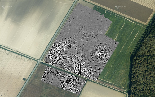
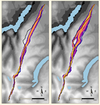
Digital surface models of crops used in archaeological feature detection – a case study of Late Neolithic site Tomašanci-Dubrava in Eastern CroatiaWhat lies on top lies also beneath? Connecting crop surface modelling to buried archaeology mapping.Recommended by Markos Katsianis based on reviews by Ian Moffat and Geert Verhoeven
This paper (Sosic et al. 2024) explores the Neolithic landscape of the Sopot culture in Đakovština, Eastern Slavonija, revealing a network of settlements through a multi-faceted approach that combines aerial archaeology, magnetometry, excavation, and field survey. This strategy facilitates scalable research tailored to the particularities of each site and allows for improved representations of buried archaeology with minimal intrusion. Using the site of Tomašanci-Dubrava as an example of the overall approach, the study further explores the use of drone imagery for 3D surface modeling, revealing a consistent correlation between crop surface elevation during full plant growth and ground terrain after ploughing, attributed to subsurface archaeological features. Results are correlated with magnetic survey and test-pitting data to validate the micro-topography and clarify the relationship between different subsurface structures. The results obtained are presented in a comprehensive way, including their source data, and are contextualized in relation to conventional cropmark detection approaches and expectations. I found this aspect very interesting, since the crop surface and terrain models contradict typical or textbook examples of cropmark detection, where the vegetation is projected to appear higher in ditches and lower in areas with buried archaeology (Renfrew & Bahn 2016, 82). Regardless, the findings suggest the potential for broader applications of crop surface or canopy height modelling in landscape wide surveys, utilizing ALS data or aerial photographs. It seems then that the authors make a valid argument for a layered approach in landscape-based site detection, where aerial imagery can be used to accurately map the topography of areas of interest, which can then be further examined at site scale using more demanding methods, such as geophysical survey and excavation. This scalability enhances the research's relevance in broader archaeological and geographical contexts and renders it a useful example in site detection and landscape-scale mapping. References Renfrew, C. and Bahn, P. (2016). Archaeology: theories, methods and practice. Thames and Hudson. Sosic Klindzic, R., Vuković, M., Kalafatić, H. and Šiljeg, B. (2024). Digital surface models of crops used in archaeological feature detection – a case study of Late Neolithic site Tomašanci-Dubrava in Eastern Croatia, Zenodo, 7970703, ver. 4 peer-reviewed and recommended by Peer Community in Archaeology. https://doi.org/10.5281/zenodo.7970703 | Digital surface models of crops used in archaeological feature detection – a case study of Late Neolithic site Tomašanci-Dubrava in Eastern Croatia | Sosic Klindzic Rajna; Vuković Miroslav; Kalafatić Hrvoje; Šiljeg Bartul | <p>This paper presents the results of a study on the neolithic landscape of the Sopot culture in the area of Đakovština in Eastern Slavonija. A vast network of settlements was uncovered using aerial archaeology, which was further confirmed and chr... | | Landscape archaeology, Neolithic, Remote sensing, Spatial analysis | Markos Katsianis | 2023-09-01 12:57:04 | ||
19 Jun 2020
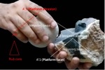
Platforms of Palaeolithic knappers reveal complex linguistic abilitiesThe means of complexity in a lithic reduction sequenceRecommended by Marta Arzarello based on reviews by Antony Borel and 1 anonymous reviewer
The paper entitled “Platforms of Palaeolithic knappers reveal complex linguistic abilities” [1] submitted by C. Gaucherel and C. Noûs represents an interesting reflection about the possibilities to detect the human cognitive abilities in relation to the lithic production. The definition and the study of human cognitive abilities during the Lower Palaeolithic it has always been a complex field of investigation. The relation between the technical skills (lithic production) and the emergence of the linguistic abilities is not easy to investigate due to the difficulty of finding objective data to refer to. The proposition, made by C. Gaucherel and C. Noûs, of a formal grammar of knapping as a method to study the syntactical organisation of the reduction sequences, constitute a new and theoretical useful approach. In order to effectively and precisely define the gestures linked to a specific reduction sequence, for example that of the handaxes shaping, a very large number of variables should be taken into consideration (morphology and quality of the raw material, experience of the knapper, context, percussion technique, forecast of use of the handaxe, etc.). But since a simplification, that brings more elements than the classic one [2,3] is needed, the “action grammar approach” can be a good instrument to detect the common element in a shaping reduction sequence. Furthermore, one of the advantages of the proposed methodology lies in the fact that the definition of the different STs (Stone Technology) can be done according to the technological specific characteristics to be studied and to the type of instrument produced. The deconstruction of knapping sequences could help to detect the degree of complexity of the different steps of the reduction sequences also thanks to the identification of the sub-actions types. The increasing/decreasing of complexity is a very complicate concept in lithic technology. Since at the base of the lithic production there are two basic concepts (angle between the striking platform and the debitage surface - convexity of the debitage/façonnage surface) which are simply declined in an increasingly complex way, it is not easy to define uniquely in what exactly consists the increase in complexity. The approach proposed in the paper “Platforms of Palaeolithic knappers reveal complex linguistic abilities” can help to have new evidences, according to the identification of the required cognitive abilities. The proposed example of formal grammar still needs to be confirmed on archaeological collections, but it is probable that a practical application will allow to further develop the methodology and possibly to highlight additional possibilities of the approach. Bibliography [1] Gaucherel, C. and Noûs C. (2020). Platforms of Palaeolithic knappers reveal complex linguistic abilities. Paleorxiv, wn5za, ver. 6 peer-reviewed and recommended by PCI Archaeology. doi: 10.31233/osf.io/wn5za | Platforms of Palaeolithic knappers reveal complex linguistic abilities | Cédric Gaucherel and Camille Noûs | <p>Recent studies in cognitive neurosciences have postulated a possible link between manual praxis such as tool-making and human languages. If confirmed, such a link opens significant avenues towards the study of the evolution of natural languages... | | Africa, Ancient Palaeolithic, Lithic technology, Theoretical archaeology | Marta Arzarello | 2020-04-30 14:18:26 | ||
01 Dec 2021
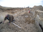
A closer look at an eroded dune landscape: first functional insights into the Federmessergruppen site of Lommel-MaatheidePotential of a large-scale functional analysis to reconstructing past human activities at the Final Palaeolithic site of Lommel-MaatheideRecommended by Marta Arzarello and Alice Leplongeon based on reviews by Gabriele Luigi Francesco Berruti and Ana Abrunhosa
The paper “A closer look at an eroded dune landscape: first functional insights into the Federmessergruppen site of Lommel-Maatheide” [1] focuses on the final Palaeolithic (Federmesser) site of Lommel-Maatheide. Federmesser sites from northern Belgium such as Lommel-Maatheide, Meer and Rekem, show evidence for dense human occupation of specific areas located on top of Tardiglacial dunes nearby water bodies [2]. Preserved spatial distribution of finds at the sites suggest different activity areas and the presence of habitat structures [2]. However, because of the low organic preservation at the sites, functional analyses of lithic assemblages have the potential to significantly contribute to the spatial organisation of activities at these sites. This study by Tomasso et al. [1], represents an excellent example of a large-scale integrated approach to the study of lithic industries. The article undoubtedly demonstrates the potential of the proposed methodology and the reliability of the results obtained. The article explores two different aspects (linked and excellently interconnected here): the possibility to apply use wear, residue and fracture analyses, on lithic assemblages affected by taphonomical alterations and to study lithic assemblages from dune landscapes. The study allows to answer differentiated questions: what is the influence of taphonomical alterations on use wear analysis? How do excavation methods impact the formation of use wear and the preservation of residues? Can we recognize distinct domestic activities? The article also provides an interesting hypothesis about hunting activities and propulsion methods. The applied methodology is effectively interdisciplinary and innovative. It demonstrates how a truly integrated and articulated approach can represent the turning point for going beyond a mainly descriptive dimension to move towards a real understanding of the sites. Studies dedicated to the analysis of the propulsion mode are not very frequent, but they are surely very important to better understand human behaviour [3]. Here, the methodology developed for the evaluation of the propulsion mode represent an important starting point for the definition of a new approach. Morphological and morphometrical analysis are integrated to the evaluation of the mechanical stress, to fracture delineations and to the hafting system (the latter defined on experimental basis). This article therefore underlines the potential of combining different approaches to functional analysis associated with a ‘tailored’ reference collection and applying them to a high number of artefacts for reconstructing past human activities involving materials that are otherwise not preserved in these contexts. [1] Tomasso, S., Cnuts, D., Coppe, J., Geerts, F., Gils, M.V., Bie, M.D., Rots, V. (2021). A closer look at an eroded dune landscape: first functional insights into the Federmessergruppen site of Lommel-Maatheide. https://doi.org/10.31219/osf.io/pf3sm, ver 3 peer-reviewed and recommended by PCI Archaeology. [2] De Bie, M., Van Gils, M. (2006). Les habitats des groupes à Federmesser (aziliens) dans le Nord de la Belgique. Bulletin de la Société préhistorique française, 103, 781–790. [3] Coppe, J., Lepers, C., Clarenne, V., Delaunois, E., Pirlot, M. and Rots V. (2019). Ballistic Study Tackles Kinetic Energy Values of Palaeolithic Weaponry. Archaeometry, (61)4, 933-956. https://doi.org/10.1111/arcm.12452 | A closer look at an eroded dune landscape: first functional insights into the Federmessergruppen site of Lommel-Maatheide | Sonja Tomasso, Dries Cnuts, Justin Coppe, Marijn Van Gils, Ferdi Geerts, Marc De Bie, Veerle Rots | <p>The vast Federmessergruppen site of Lommel-Maatheide, which is located in the Campine region (Northern Belgium), revealed the presence of numerous Final Palaeolithic concentrations situated on a large Late Glacial sand ridge on the northern edg... | | Environmental archaeology, Landscape archaeology, Lithic technology, Traceology, Upper Palaeolithic | Marta Arzarello | 2021-09-14 17:04:38 | ||
06 Oct 2023
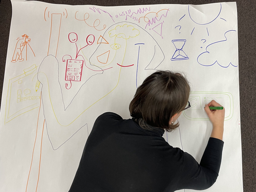
Body Mapping the Digital: Visually representing the impact of technology on archaeological practice.Understanding archaeological documentation through a participatory, arts-based approachRecommended by Nicolo Dell'Unto based on reviews by 2 anonymous reviewersThis paper presents the use of a participatory arts-based methodology to understand how digital and analogue tools affect individuals' participation in the process of archaeological recording and interpretation. The preliminary results of this work highlight the importance of rethinking archaeologists' relationship with different recording methods, emphasising the need to recognise the value of both approaches and to adopt a documentation strategy that exploits the strengths of both analogue and digital methods. Although a larger group of participants with broader and more varied experience would have provided a clearer picture of the impact of technology on current archaeological practice, the article makes an important contribution in highlighting the complex and not always easy transition that archaeologists trained in analogue methods are currently experiencing when using digital technology. This is assessed by using arts-based methodologies to enable archaeologists to consider how digital technologies are changing the relationship between mind, body and practice. I found the range of experiences described in the papers by the archaeologists involved in the experiment particularly interesting and very representative of the change in practice that we are all experiencing. As the article notes, the two approaches cannot be directly compared because they offer different possibilities: if analogue methods foster a deeper connection with the archaeological material, digital documentation seems to be perceived as more effective in terms of data capture, information exchange and data sharing (Araar et al., 2023). It seems to me that an important element to consider in such a study is the generational shift and the incredible divide between native and non-native digital. The critical issues highlighted in the paper are central and provide important directions for navigating this ongoing (digital) transition. References Araar, L., Morgan, C. and Fowler, L. (2023) Body Mapping the Digital: Visually representing the impact of technology on archaeological practice., Zenodo, 7990581, ver. 5 peer-reviewed and recommended by Peer Community in Archaeology. https://doi.org/10.5281/zenodo.7990581 | Body Mapping the Digital: Visually representing the impact of technology on archaeological practice. | Araar, Leila; Morgan, Colleen; Fowler, Louise | <p>This paper uses a participatory, art-based methodology to understand how digital and analog tools impact individuals' experience and perceptions of archaeological recording. Body mapping involves the co-creation of life-sized drawings and narra... | | Computational archaeology, Theoretical archaeology | Nicolo Dell'Unto | 2023-06-01 09:06:52 | ||
12 Dec 2022
Can growth in captivity alter the calcaneal microanatomy of a wild ungulate?Mobility in pigs: A microanatomical perspectiveRecommended by Nimrod Marom based on reviews by Max Price and Ignacio A. Lazagabaster
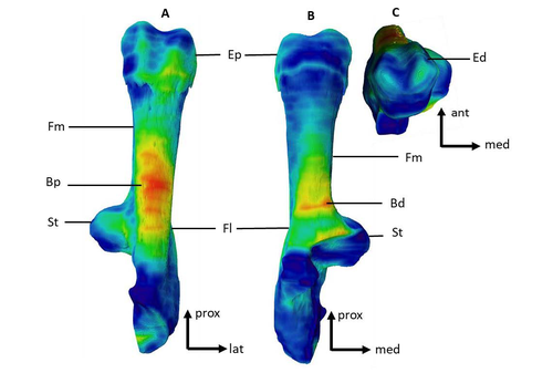
Pig domestication and husbandry involved complex processes of introduction, introgression, and feralization that challenge our understanding of human/suid interactions in ancient times. This challenge is a constant stimulus for the development of novel methods and techniques to illuminate aspects of early pig husbandry, such as human-induced changes in mobility. Using geometric morphometrics, Harbers et al. (2020) have shown that the calcaneus records a plastic response to reduced mobility and hence to human management. In the present study, Cottereau et al. (2022) explore the possibility that a similar plastic response to different mobility regimes can be observed in the microanatomy of the calcaneus using CT scans. Their research utilizes a sample of calcanei obtained from Mesolithic specimens, and also from recent suids kept in natural habitat, large pen, and stall. Their results suggest that bone microanatomy is more affected by population differences than by mobility patterns, as illustrated by the similarity between Mesolitic boar calcanei and their difference from recent, free wild boar.
References Cottereau R, Ortiz K, Locatelli Y, Houssaye A, Cucchi T (2022), bioRxiv, 504790, ver. 5 peer-reviewed and recommended by Peer Community in Archaeology. https://doi.org/10.1101/2022.08.22.504790 Harbers H, Neaux D, Ortiz K, Blanc B, Laurens F, Baly I, Callou C, Schafberg R, Haruda A, Lecompte F, Casabianca F, Studer J, Renaud S, Cornette R, Locatelli Y, Vigne J-D, Herrel A, Cucchi T (2020) The mark of captivity: plastic responses in the ankle bone of a wild ungulate (Sus scrofa). Royal Society Open Science, 7, 192039. https://doi.org/10.1098/rsos.192039
| Can growth in captivity alter the calcaneal microanatomy of a wild ungulate? | Romain Cottereau, Katia Ortiz, Yann Locatelli, Alexandra Houssaye*, Thomas Cucchi* | <p style="text-align: justify;">Reduced mobility associated with captivity induce changes in biomechanical stress on the skeleton of domesticated animals. Due to bone plasticity, the morphology and the internal structure of the bones can respond t... | | Neolithic, Zooarchaeology | Nimrod Marom | 2022-08-26 20:29:01 | ||
02 Nov 2020
Probabilistic Modelling using Monte Carlo Simulation for Incorporating Uncertainty in Least Cost Path Results: a Roman Road Case StudyA probabilistic method for Least Cost Path calculation.Recommended by Otis Crandell based on reviews by Georges Abou Diwan and 1 anonymous reviewerThe paper entitled “Probabilistic Modelling using Monte Carlo Simulation for Incorporating Uncertainty in Least Cost Path Results: a Roman Road Case Study” [1] submitted by J. Lewis presents an innovative approach to applying Least Cost Path (LCP) analysis to incorporate uncertainty of the Digital Elevation Model used as the topographic surface on which the path is calculated. The proposition of using Monte Carlo simulations to produce numerous LCP, each with a slightly different DEM included in the error range of the model, allows one to strengthen the method by proposing a probabilistic LCP rather than a single and arbitrary one which does not take into account the uncertainty of the topographic reconstruction. This new method is integrated in the R package leastcostpath [2]. The author tests the method using a Roman road built along a ridge in Cumbria, England. The integration of the uncertainty of the DEM, thanks to Monte Carlo simulations, shows that two paths could have the same probability to be the real LCP. One of them is indeed the path that the Roman road took. In particular, it is one of two possibilities of LCP in the south to north direction. This new probabilistic method therefore strengthens the reconstruction of past pathways, while also allowing new hypotheses to be tested, and, in this case study, to suggest that the northern part of the Roman road’s location was selected to help the northward movements. [1] Lewis, J., 2020. Probabilistic Modelling using Monte Carlo Simulation for Incorporating Uncertainty in Least Cost Path Results: a Roman Road Case Study. SocArXiv, mxas2, ver 17 peer-reviewed and recommended by PCI Archaeology, 10.31235/osf.io/mxas2. [2] Lewis, J., 2020. leastcostpath: Modelling Pathways and Movement Potential Within a Landscape. R package. Version 1.7.4. | Probabilistic Modelling using Monte Carlo Simulation for Incorporating Uncertainty in Least Cost Path Results: a Roman Road Case Study | Joseph Lewis | <p>The movement of past peoples in the landscape has been studied extensively through the use of Least Cost Path (LCP) analysis. Although methodological issues of applying LCP analysis in Archaeology have frequently been discussed, the effect of v... | | Spatial analysis | Otis Crandell | Adam Green, Georges Abou Diwan | 2020-08-05 12:10:46 | |
15 Aug 2021
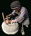
Ran-thok and Ling-chhom: indigenous grinding stones of Shertukpen tribes of Arunachal Pradesh, IndiaAn insight into traditional method of food production in IndiaRecommended by Otis Crandell based on reviews by Antony Borel, Atefeh Shekofteh, Andrea Squitieri, Birgül Ögüt, Atefe Shekofte and 1 anonymous reviewerThis paper [1] covers an interesting topic in that it presents through ethnography an insight into a traditional method of food production which is gradually declining in use. In addition to preserving traditional knowledge, the ethnographic study of grinding stones has the potential for showing how similar tools may have been used by people in the past, particularly from the same geographic region. [1] Thongdok Norbu J., Nimasow Gibji, Nimasow Oyi D. (2021) Ran-thok and Ling-chhom: indigenous grinding stones of Shertukpen tribes of Arunachal Pradesh, India. Zenodo, 5118675, ver. 4 peer-reviewed and recommended by PCI Archaeo. doi: https://doi.org/10.5281/zenodo.5118675 | Ran-thok and Ling-chhom: indigenous grinding stones of Shertukpen tribes of Arunachal Pradesh, India | Norbu Jamchu Thongdok, Gibji Nimasow & Oyi Dai Nimasow | <p style="text-align: justify;">The Shertukpens are an Indigenous tribal group inhabiting the western and southern parts of Arunachal Pradesh, Northeast India. They are accomplished carvers of carving wood and stone. The paper aims to document the... | | Antiquity, Asia, Environmental archaeology, Lithic technology, Peopling, Raw materials | Otis Crandell | 2021-02-10 10:26:12 |


