
Latest recommendations

| Id | Title | Authors | Abstract | Picture | Thematic fields | Recommender▼ | Reviewers | Submission date | |
|---|---|---|---|---|---|---|---|---|---|
11 Dec 2023
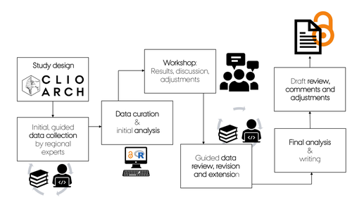
A meta-analysis of Final Palaeolithic/earliest Mesolithic cultural taxonomy and evolution in EuropeQuestioning Final Palaeolithic and early Mesolithic cultural taxonomy with a data-driven statistical approachRecommended by Anaïs Vignoles based on reviews by Dirk Leder and 2 anonymous reviewersCultural taxonomies are an essential tool for archaeologists working with prehistoric material cultures as they have historically been used to create the basic analytical units for studying cultural evolution through time (de Mortillet, 1883 ; Breuil, 1913). This approach has its limits as the taxonomic units are essentially etic constructions, i.e., they are defined in a cultural context exterior to the one that produced the material culture on which they are based (e.g., Pesesse, 2019). But to approach questions related to cultural evolution, one has to define archaeological units with clear geographic and chronological delineations in order to be compared synchronically and diachronically (e.g., Willey and Philips, 1958). In « A meta-analysis of Final Palaeolitic/Earliest Mesolithic cultural taxonomy and evolution in Europe », F. Riede and colleagues propose a novel and interesting approach to question the end of the Palaeolithic and beginning of the Mesolithic’s « named archaeological cultures » (NACs) analytical pertinence (Riede et al., 2023). In this particular context, NACs are indeed very numerous (n = 86) and result from complex and regional research histories. It seems thus pertinent to question the extent to which the said NACs chronological and geographic patterns result from past cultural diversity and evolution, and are not artefacts of research. To do so, the authors adopted a data-driven approach that they describe in detail in the paper. First, they gathered an European data base of lithic tool-kit composition, blade and bladelet technology and armature morphology at 350 key sites considered representative of NACs, dated between 15 and 11 ka (Hussain et al., 2023). These data were then analyzed using geometric morphometrics and a set of statisticaal tests in order to 1) test the coherence of these taxonomic units, and 2) test the chronological change in artefact shape variation. The authors conclude that the data set is partially biased by reasearch practices and histories, as their data-driven approach has only partially replicated traditional NACs for the european Late Palaeolithic/Early Mesolithic. However, their analysis of armature shape evolution has shown a tendency to diversification overtime, a pattern that was already observed in more « traditional » approaches. This study is, in my opinion, an excellent contribution for a significant step in macro-regional approaches to the archaeological record: defining discrete archaeological units that serve as a basis for subsequent analyses aimed at delineating cultural evolutionary processes. The authors propose a carefully designed and statistically grounded procedure in order to achieve these definitions in the most replicable and explicit possible manner. Taking advantage of drawings as a primary source of information is also very original despite several limitations of this approach (such as the necessary selection of most typical artefacts to be represented, the incompleteness of data publication or the difficulty to access all published work across such a large geographic area). The results of the study are convincing enough to allow the authors to discuss the pertinence of European Late Paleo/Early Mesolithic NACs, the potential epistemological and historical factors that could affect this taxonomic framework, as well as to give more weight to the traditional hypothesis of lithic cultural diversification towards the end of the Pleistocene/beginning of the Holocene in Europe. I would also like to underline the authors’ important efforts to ensure transparence and replicability of their study, as well as the accessibility of the data, thanks to extensive supplementary data and a data paper describing their data set in detail. Anaïs L. Vignoles References Breuil, H. (1913). Les subdivisions du paléolithique supérieur et leur signification. In Congrès international d’anthropologie et d’archéologie préhistoriques - compte-rendu de la XIVème session, tome 1:165‑238. Genève: Imprimerie Albert Kündig. Hussain, S. T., Riede, F., Matzig, D. N., Biard, M., Crombé, P., Fernández-Lopéz de Pablo, J., Fontana, F., Groß, D., Hess, T., Langlais, M., Mevel, L., Mills, W., Moník, M., Naudinot, N., Posch, C., Rimkus, T., Stefański, D. and Vandendriessche, H. (2023). A Pan-European Dataset Revealing Variability in Lithic Technology, Toolkits, and Artefact Shapes ~15-11 Kya. Scientific Data 10 (1): 593. https://doi.org/10.1038/s41597-023-02500-9. Mortillet, G. (1883). Le Préhistorique, antiquité de l’homme. Reinwald. Paris. Pesesse, D. (2019). Analyser un silex, le façonner à nouveau ? Sur certains usages de la chaîne opératoire au Paléolithique supérieur. Techniques & culture, no 71: 74‑77. https://doi.org/10.4000/tc.11321. Riede, F., Matzig, D. N., Biard, M., Crombé, P., Fernández-Lopéz de Pablo, J., Fontana, F., Groß, D., Hess, T., Langlais, M., Mevel, L., Mills, W., Moník, M., Naudinot, N., Posch, C., Rimkus, T., Stefański, D., Vandendriessche, H. and Hussain, S. T. (2023). A meta-analysis of Final Palaeolithic/earliest Mesolithic cultural taxonomy and evolution in Europe, Zenodo, 8195587., ver. 3 peer-reviewed and recommended by Peer Community in Archaeology. https://doi.org/10.5281/zenodo.8195587 Willey, G. R. and Phillips, P. (1958). Method and Theory in American Archaeology. Chicago, IL: The University of Chicago Press. | A meta-analysis of Final Palaeolithic/earliest Mesolithic cultural taxonomy and evolution in Europe | Felix Riede, David N. Matzig, Miguel Biard, Philippe Crombé, Javier Fernández-Lopéz de Pablo, Federica Fontana, Daniel Groß, Thomas Hess, Mathieu Langlais, Ludovic Mevel, William Mills, Martin Moník, Nicolas Naudinot, Caroline Posch, Tomas Rimkus,... | <p>Archaeological systematics, together with spatial and chronological information, are commonly used to infer cultural evolutionary dynamics in the past. For the study of the Palaeolithic, and particularly the European Final Palaeolithic and earl... | | Computational archaeology, Europe, Lithic technology, Mesolithic, Upper Palaeolithic | Anaïs Vignoles | 2023-07-29 16:06:17 | ||
20 Dec 2020
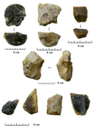
For our world without sound. The opportunistic debitage in the Italian context: a methodological evaluation of the lithic assemblages of Pirro Nord, Cà Belvedere di Montepoggiolo, Ciota Ciara cave and Riparo Tagliente.Investigating the opportunistic debitage – an experimental approachRecommended by Alice Leplongeon based on reviews by David Hérisson and 1 anonymous reviewerThe paper “For our world without sound. The opportunistic debitage in the Italian context: a methodological evaluation of the lithic assemblages of Pirro Nord, Cà Belvedere di Montepoggiolo, Ciota Ciara cave and Riparo Tagliente” [1] submitted by M. Carpentieri and M. Arzarello is a welcome addition to a growing number of studies focusing on flaking methods showing little to no core preparation, e.g., [2–4]. These flaking methods are often overlooked or seen as ‘simple’, which, in a Middle Palaeolithic context, sometimes leads to a dichotomy of Levallois vs. non-Levallois debitage (e.g., see discussion in [2]). The authors address this topic by first providing a definition for ‘opportunistic debitage’, derived from the definition of the ‘Alternating Surfaces Debitage System’ (SSDA, [5]). At the core of the definition is the adaptation to the characteristics (e.g., natural convexities and quality) of the raw material. This is one main challenge in studying this type of debitage in a consistent way, as the opportunistic debitage leads to a wide range of core and flake morphologies, which have sometimes been interpreted as resulting from different technical behaviours, but which the authors argue are part of a same ‘methodological substratum’ [1]. This article aims to further characterise the ‘opportunistic debitage’. The study relies on four archaeological assemblages from Italy, ranging from the Lower to the Upper Pleistocene, in which the opportunistic debitage has been recognised. Based on the characteristics associated with the occurrence of the opportunistic debitage in these assemblages, an experimental replication of the opportunistic debitage using the same raw materials found at these sites was conducted, with the aim to gain new insights into the method. Results show that experimental flakes and cores are comparable to the ones identified as resulting from the opportunistic debitage in the archaeological assemblage, and further highlight the high versatility of the opportunistic method. One outcome of the experimental replication is that a higher flake productivity is noted in the opportunistic centripetal debitage, along with the occurrence of 'predetermined-like' products (such as déjeté points). This brings the authors to formulate the hypothesis that the opportunistic debitage may have had a role in the process that will eventually lead to the development of Levallois and Discoid technologies. How this articulates with for example current discussions on the origins of Levallois technologies (e.g., [6–8]) is an interesting research avenue. This study also touches upon the question of how the implementation of one knapping method may be influenced by the broader technological knowledge of the knapper(s) (e.g., in a context where Levallois methods were common vs a context where they were not). It makes the case for a renewed attention in lithic studies for flaking methods usually considered as less behaviourally significant. [1] Carpentieri M, Arzarello M. 2020. For our world without sound. The opportunistic debitage in the Italian context: a methodological evaluation of the lithic assemblages of Pirro Nord, Cà Belvedere di Montepoggiolo, Ciota Ciara cave and Riparo Tagliente. OSF Preprints, doi:10.31219/osf.io/2ptjb [2] Bourguignon L, Delagnes A, Meignen L. 2005. Systèmes de production lithique, gestion des outillages et territoires au Paléolithique moyen : où se trouve la complexité ? Editions APDCA, Antibes, pp. 75–86. Available: https://halshs.archives-ouvertes.fr/halshs-00447352 [3] Arzarello M, De Weyer L, Peretto C. 2016. The first European peopling and the Italian case: Peculiarities and “opportunism.” Quaternary International, 393: 41–50. doi:10.1016/j.quaint.2015.11.005 [4] Vaquero M, Romagnoli F. 2018. Searching for Lazy People: the Significance of Expedient Behavior in the Interpretation of Paleolithic Assemblages. J Archaeol Method Theory, 25: 334–367. doi:10.1007/s10816-017-9339-x [5] Forestier H. 1993. Le Clactonien : mise en application d’une nouvelle méthode de débitage s’inscrivant dans la variabilité des systèmes de production lithique du Paléolithique ancien. Paléo, 5: 53–82. doi:10.3406/pal.1993.1104 [6] Moncel M-H, Ashton N, Arzarello M, Fontana F, Lamotte A, Scott B, et al. 2020. Early Levallois core technology between Marine Isotope Stage 12 and 9 in Western Europe. Journal of Human Evolution, 139: 102735. doi:10.1016/j.jhevol.2019.102735 [7] White M, Ashton N, Scott B. 2010. The emergence, diversity and significance of the Mode 3 (prepared core) technologies. Elsevier. In: Ashton N, Lewis SG, Stringer CB, editors. The ancient human occupation of Britain. Elsevier. Amsterdam, pp. 53–66. [8] White M, Ashton N. 2003. Lower Palaeolithic Core Technology and the Origins of the Levallois Method in North‐Western Europe. Current Anthropology, 44: 598–609. doi:10.1086/377653 | For our world without sound. The opportunistic debitage in the Italian context: a methodological evaluation of the lithic assemblages of Pirro Nord, Cà Belvedere di Montepoggiolo, Ciota Ciara cave and Riparo Tagliente. | Marco Carpentieri, Marta Arzarello | <p>The opportunistic debitage, originally adapted from Forestier’s S.S.D.A. definition, is characterized by a strong adaptability to local raw material morphology and its physical characteristics and it is oriented towards flake production. Its mo... | | Ancient Palaeolithic, Lithic technology, Middle Palaeolithic | Alice Leplongeon | 2020-07-23 14:26:04 | ||
26 Mar 2024
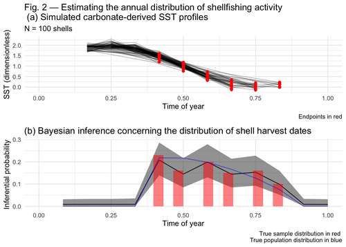
Inferring shellfishing seasonality from the isotopic composition of biogenic carbonate: A Bayesian approachMixture models and seasonal mobilityRecommended by Alfredo Cortell-Nicolau and Simon Carrignon based on reviews by Iza Romanowska and 1 anonymous reviewerThe paper by Brown & Lewis [1] presents an approach to measure seasonal mobility and subsistence practices. In order to do so, the paper proposes a Bayesian mixture model to estimate the annual distribution of shellfish harvesting activity. Following the recommendations of the two reviewers, the paper presents a clear and innovative method to assess seasonal mobility for prehistoric groups, although it could benefit from additional references regarding isotopic literature. While the adequacy of isotope analysis for estimating mobility patterns in Archaeology has been extensively proven by now, work on specific seasonal mobility is not that much abundant. However, this is a key issue, since seasonal mobility is one of the main social components defining the differences between groups both considering farming vs hunting and gathering or even among hunter-gatherer groups themselves. In this regard, the paper brings a valuable methodological resources that can be used for further research in this issue. One of its greatest values is the fact that it can quantify the uncertainty present in previous isotope studies in seasonal mobility. As stated by the authors, the model can still undergo several optimisation aspects, but as it stands, it is already providing a valuable asset regarding the quantification of uncertainy in the isotopic studies of seasonal mobility. Reference [1] Brown, J. and Lewis, G. (2024). Inferring shellfishing seasonality from the isotopic composition of biogenic carbonate: A Bayesian approach. Zenodo, 7949547, ver. 3 peer-reviewed and recommended by Peer Community in Archaeology. https://doi.org/10.5281/zenodo.7949547 | Inferring shellfishing seasonality from the isotopic composition of biogenic carbonate: A Bayesian approach | Jordan Brown and Gabriel Lewis | <p>The problem of accurately and reliably estimating the annual distribution of seasonally-varying human settlement and subsistence practices is a classic concern among archaeologists, which has only become more relevant with the increasing import... | | Archaeometry, Computational archaeology, Environmental archaeology, North America, Palaeontology, Paleoenvironment, Zooarchaeology | Alfredo Cortell-Nicolau | Iza Romanowska, Eduardo Herrera Malatesta, Alejandro Sierra Sainz-Aja, Sam Leggett, Christianne Fernee, Anonymous, Asier García-Escárzaga , Paul Szpak , Maria Elena Castiello , Jasmine Lundy , Tansy Branscombe | 2023-10-03 04:45:54 | |
02 Apr 2024
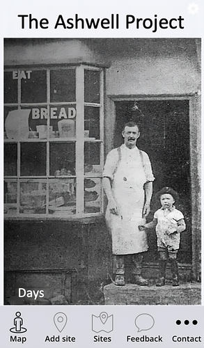
The Ashwell Project: Creating an Online Geospatial CommunityA nice project looking at under-represented demographicRecommended by Alexis Pantos based on reviews by Catriona Cooper and Steinar Kristensen based on reviews by Catriona Cooper and Steinar Kristensen
The paper by A. Lien-Talks [1] presents a small project looking at the use of crowd sourced data collection and particpatory GIS. In particular it looks at the potential of these tools in response to socially disruptive and isolating events such as the COVID-19 pandemic as well as the potential role of digitially mediated heritage initiatives in tackling some of the challenges of changing demographics and life styles. The types of technologies employed are relatively mature, the project identifies potential for such approaches to be used within the local-history/local community settings, though is also a reminer that depsite the much broader adoption of technology within all areas of society than even a few years ago many barriers still remain. While the the sample size and data collected in the project is relatively modest, the focus on empathy toward the intended audiences from the design process, as well as some of the qualitative feedback reported serve as a reminder that participatory, or crowd-sourced data collection initiatives in heritage can, and perhaps should place potential social benefit before data-acquisition of objectives. The project also presents a demographic that is not often represented within the literature and the publication and as such the publication of the article represents a meaningful contribution to ongoing discussions of the role heritage and digitally mediated community archaeology can play a role in developing our societies. References [1] Lien-Talks, A. (2024). The Ashwell Project: Creating an Online Geospatial Community. Zenodo, 8307882, ver. 4 peer-reviewed and recommended by Peer Community in Archaeology. https://doi.org/10.5281/zenodo.8307882 | The Ashwell Project: Creating an Online Geospatial Community | Alphaeus Lien-Talks | <p>Background:<br>As the world becomes increasingly digital, so too must the way in which archaeologists engage with the public. This was particularly important during the COVID-19 pandemic, and many outreach and engagement efforts began to move o... | | Computational archaeology | Alexis Pantos | 2023-09-01 11:25:54 | ||
16 Apr 2024
Creating an Additional Class Layer with Machine Learning to counter Overfitting in an Unbalanced Ancient Coin DatasetA significant contribution to the problem of unbalanced data in machine learning research in archaeologyRecommended by Alex Brandsen based on reviews by Simon Carrignon, Joel Santos and 1 anonymous reviewer
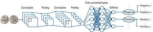
This paper [1] presents an innovative approach to address the prevalent challenge of unbalanced datasets in coin type recognition, shifting the focus from coin class type recognition to coin mint recognition. Despite this shift, the issue of unbalanced data persists. To mitigate this, the authors introduce a method to split larger classes into smaller ones, integrating them into an 'additional class layer'. Three distinct machine learning (ML) methodologies were employed to identify new possible classes, with one approach utilising unsupervised clustering alongside manual intervention, while the others leverage object detection, and Natural Language Processing (NLP) techniques. However, despite these efforts, overfitting remained a persistent issue, prompting the authors to explore alternative methods such as dataset improvement and Generative Adversarial Networks (GANs). The paper contributes significantly to the intersection of ML techniques and archaeology, particularly in addressing overfitting challenges. Furthermore, the authors' candid acknowledgment of the limitations of their approaches serves as a valuable resource for researchers encountering similar obstacles. This study stems from the D4N4 project, aimed at developing a machine learning-based coin recognition model for the extensive "Corpus Nummorum" dataset, comprising over 19,600 coin types and 49,000 coins from various ancient landscapes. Despite encountering challenges with overfitting due to the dataset's imbalance, the authors' exploration of multiple methodologies and transparent documentation of their limitations enriches the academic discourse and provides a foundation for future research in this field. Reference [1] Gampe, S. and Tolle, K. (2024). Creating an Additional Class Layer with Machine Learning to counter Overfitting in an Unbalanced Ancient Coin Dataset. Zenodo, 8298077, ver. 4 peer-reviewed and recommended by Peer Community in Archaeology. https://doi.org/10.5281/zenodo.8298077 | Creating an Additional Class Layer with Machine Learning to counter Overfitting in an Unbalanced Ancient Coin Dataset | Sebastian Gampe, Karsten Tolle | <p>We have implemented an approach based on Convolutional Neural Networks (CNN) for mint recognition for our Corpus Nummorum (CN) coin dataset as an alternative to coin type recognition, since we had too few instances for most of the types (classe... | | Computational archaeology | Alex Brandsen | 2023-08-29 16:26:41 | ||
14 May 2024

Supporting the analysis of a large coin hoard with AI-based methodsA demonstration of the use and finetuning of existing machine learning tools for analysing large complexes of coinsRecommended by Alex Brandsen based on reviews by 2 anonymous reviewers
The paper outlines the ClaReNet project's exploration of computer-based methods for classifying Celtic coin series, specifically focusing on a hoard from Jersey [1]. They collaborated with Jersey Heritage and numismatists, utilising a large dataset of coin images. The process involves stages such as pre-sorting, size-based sorting, class/type identification, and die studies. They employed IT methods, including object detection and unsupervised learning, followed by supervised learning for data refinement. Collaboration with numismatic experts ensured data quality. The study highlighted challenges in classifying coins, suggesting techniques like image matching alongside convolutional neural networks (CNNs). The results demonstrate the efficacy of semi-automatic processes in coin classification, emphasising the importance of human-computer collaboration for successful outcomes. Overall, this is a good paper, showing how we as archaeologists and numismatics can use existing tools and finetune them for our purposes; without the need for huge domain specific datasets. This research and related papers show how we can more effectively deal with the increasingly bigger data we deal with, saving time on the monotonous and labour intensive tasks, leaving us more time to deal with the big picture. An important strength of the work is the provided public software repository and the dataset. The paper is well written, and a number of images illustrate the methodology as well as the objects used. Reference [1] Deligio, C., Tolle, K., and Wigg-Wolf, D. (2024). Supporting the analysis of a large coin hoard with AI-based methods. Zenodo, 8301464, ver. 4 peer-reviewed and recommended by Peer Community in Archaeology. https://doi.org/10.5281/zenodo.8301464
| Supporting the analysis of a large coin hoard with AI-based methods | Chrisowalandis Deligio, Karsten Tolle, David Wigg-Wolf | <p>In the project "Classifications and Representations for Networks: From types and characteristics to linked open data for Celtic coinages" (ClaReNet) we had access to image data for one of the largest Celtic coin hoards ever found: Le Câtillon I... | | Computational archaeology | Alex Brandsen | 2023-08-30 15:31:16 | ||
02 May 2024
Machine Learning for UAV and Ground-Captured Imagery: Toward Standard PracticesA step forward in detecting small objects in UAV data for archaeological surveyingRecommended by Alex Brandsen based on reviews by 2 anonymous reviewers
In this paper [1], the authors describe how they apply machine learning with YOLOv5 to classify visual data, aiming to enhance understanding of archaeological phenomena before conducting destructive fieldwork. Despite challenges, the integration of machine learning with remote sensing technology was seen as transformative, enabling precise recording of areas of interest and assessment of environmental risk factors. The paper discusses successes, failures, and future directions in machine learning research, emphasising the need for standardisation and integration of streamlined methods. The application of machine learning techniques facilitates non-destructive analysis of material culture records, improving conservation efforts and offering insights into both past and contemporary phenomena. While the initial use of YOLOv5 showed potential for consistent detection of archaeological features, further refinement and dataset enlargement are deemed necessary for broader application in non-destructive archaeological surveying. The authors advocate for the integration of machine learning tools in archaeological research to save time, resources, and promote ethical digital recording practices. They highlight the importance of standardised methodologies to enhance credibility and reproducibility, aiming to contribute to the ongoing dialogue in computational archaeology. Overall, I think this paper is a good step forward in detecting small objects in UAV data, and contains useful information for similar studies. The aim towards greater reproducibility and standardisation is of course shared more widely in the machine learning community, and this study is a good example of how to approach this. References [1] Sharp, K., Christofis, B., Eslamiat, H., Nepal, U. and Osores Mendives, C. (2024). Machine Learning for UAV and Ground-Captured Imagery: Toward Standard Practices. Zenodo, 8307612, ver. 5 peer-reviewed and recommended by Peer Community in Archaeology. https://doi.org/10.5281/zenodo.8307612 | Machine Learning for UAV and Ground-Captured Imagery: Toward Standard Practices | Sharp Kayeleigh, Christofis Brooklyn, Eslamiat Hossein, Nepal Upesh, Osores Mendives Carlos | <p>Our collaborative work began in 2019 with the intent to overcome obstacles that had arisen from the inability to access curated artifact collections from remote locations. It was our specific aim to not only create digital twins of excavated ob... | | Ceramics, Computational archaeology, Remote sensing, South America | Alex Brandsen | 2023-09-01 09:56:18 | ||
29 Apr 2024
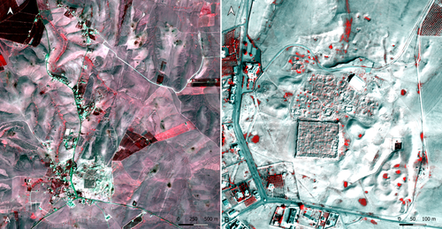
Study and enhancement of the heritage value of a fortified settlement along the Limes Arabicus. Umm ar-Rasas (Amman, Jordan) between remote sensing analysis, photogrammetry and laser scanner surveys.Integrating remote sensing and photogrammetric approaches to studying a fortified settlement along the Limes Arabicus: Umm ar‐Rasas (Amman, Jordan).Recommended by Alessia Brucato based on reviews by Francesc C. Conesa, Giuseppe Ceraudo and 1 anonymous reviewerDi Palma et alii manuscript delves into applying remote sensing and photogrammetry methods to document and analyze the castrum at the Umm er-Rasas site in Jordan. This research aimed to map all the known archaeological evidence, detect new historical structures, and create a digital archive of the site's features for study and education purposes [1]. Their research has been organized into two phases. The first one consisted of a remote sensing survey and involved collecting historical and modern aerial and satellite imagery, such as: aerial photographs by Sir Marc Aurel Stein from 1939; panchromatic spy satellite images from the Cold War period (Corona KH-4B and Hexagon KH-9); high and very high resolution (HR and VHR) modern multispectral satellite images (Pléiades-1A and Pléiades Neo-4) [1]. This dataset was processed using the ENVI 4.4 software and applying multiple image-enhancing techniques (Pansharpening, RGB composite, data fusion, and Principal Component Analysis). Then, the resulting images were integrated into a QGIS project, allowing for visual analyses of the site's features and terrain. These investigations provided: · a broad overview of the site, · the discovery of a previously unknown archaeological feature (the northeastern dam), · a stage for targeted ground-level investigations [1]. The project's second phase was dedicated to intensive fieldwork operations, including pedestrian surveys, stratigraphic excavations, and photogrammetric recordings, such as: photographic reconstructions via Structure from Motion (SfM) and laser scanner sessions (using two FARO X330 HDR). In particular, the laser scanner data were processed with Reconstructor 4.4, which provided highly detailed 3D models for the QGIS database. These results were crucial in validating the information acquired during the first phase. Overall, the paper is well written, with clear objectives and a systematic presentation of the site [2,3,10,11], the research materials, and the study phases. The dataset was described in meticulous detail (especially the remote sensing sources and the laser scanner recordings). The methods implemented in this study are rigorously described [4,5,6,7,8,9] and show a high level of integration between aerial and field techniques. The results are neatly illustrated and fit into the current debates about the efficacy of remote sensing detection and multiscale approaches in archaeological research. In conclusion, this manuscript significantly contributes to archaeological research, unveiling new and exciting findings about the site of Umm er-Rasas. Its findings and methodologies warrant publication and further exploration. References: 1. Di Palma, F., Gabrielli, R., Merola, P., Miccoli, I. and Scardozzi, G. (2024). Study and enhancement of the heritage value of a fortified settlement along the Limes Arabicus. Umm ar-Rasas (Amman, Jordan) between remote sensing analysis, photogrammetry and laser scanner surveys. Zenodo, 8306381, ver. 3 peer-reviewed and recommended by Peer Community in Archaeology. https://doi.org/10.5281/zenodo.8306381 2. Abela J. and Acconci A. (1997), Umm al‐Rasas Kastron Mefa’a. Excavation Campaign 1997. Church of St. Paul: northern and southern flanks. Liber Annus, 47, 484‐488. 3. Bujard J. (2008), Kastron Mefaa, un bourg à l'époque byzantine: Travaux de la Mission archéologique de la Fondation Max van Berchem à Umm al‐Rasas, Jordanie (1988‐1997), PhD diss., University of Fribourg 2008. 4. Cozzolino M., Gabrielli R., Galatà P., Gentile V., Greco G., Scopinaro E. (2019), Combined use of 3D metric surveys and non‐invasive geophysical surveys at the stylite tower (Umm ar‐Rasas, Jordan), Annals of geophysics, 62, 3, 1‐9. http://dx.doi.org/10.4401/ag‐8060 5. Gabrielli R., Salvatori A., Lazzari A., Portarena D. (2016), Il sito di Umm ar‐Rasas – Kastron Mefaa – Giordania. Scavare documentare conservare, viaggio nella ricerca archeologica del CNR. Roma 2016, 236‐240. 6. Gabrielli R., Portarena D., Franceschinis M. (2017), Tecniche di documentazione dei tappeti musivi del sito archeologico di Umm al‐Rasas Kastron Mefaa (Giordania). Archeologia e calcolatori, 28 (1), 201‐218. https://doi.org/10.19282/AC.28.1.2017.12 7. Lasaponara R., Masini N. (2012 ed.), Satellite Remote Sensing: A New Tool for Archaeology, New York 2012. 8. Lasaponara R., Masini N. and Scardozzi G. (2007), Immagini satellitari ad alta risoluzione e ricerca archeologica: applicazioni e casi di studio con riprese pancromatiche e multispettrali di QuickBird. Archeologia e Calcolatori, 18 (2), 187‐227. https://core.ac.uk/download/pdf/33150351.pdf 9. Lasaponara R., Masini N., Scardozzi G. (2010), Elaborazioni di immagini satellitari ad alta risoluzione e ricognizione archeologica per la conoscenza degli insediamenti rurali del territorio di Hierapolis di Frigia (Turchia). Il dialogo dei Saperi – Metodologie integrate per i Beni Culturali, Edizioni scientifiche italiane, 479‐494. 10. Piccirillo M., Abela J. and Pappalardo C. (2007), Umm al‐Rasas ‐ campagna 2007. Rapporto di scavo. Liber Annus, 57, 660‐668. 11. Poidebard A. (1934), La trace de Rome dans le désert de Syrie : le limes de Trajan à la conquête arabe ; recherches aériennes 1925 – 1932. Paris : Geuthner. | Study and enhancement of the heritage value of a fortified settlement along the Limes Arabicus. Umm ar-Rasas (Amman, Jordan) between remote sensing analysis, photogrammetry and laser scanner surveys. | Di Palma Francesca, Gabrielli Roberto, Merola Pasquale, Miccoli Ilaria, Scardozzi Giuseppe | <p>The Limes Arabicus is an excellent laboratory for experimenting with the huge potential of historical remote sensing data for identifying and mapping fortified centres along this sector of the eastern frontier of the Roman Empire and then the B... | | Antiquity, Asia, Classic, Landscape archaeology, Mediterranean, Remote sensing, Spatial analysis | Alessia Brucato | 2023-08-31 23:34:16 | ||
11 Jan 2022
Tektite geoarchaeology in mainland Southeast AsiaTektites as chronological markers: after careful geoarchaeological validation only!Recommended by Alain Queffelec and Shanti Pappu based on reviews by Sheila Mishra, Toshihiro Tada, Mike Morley and 1 anonymous reviewer
Tektites, a naturally occurring glass produced by major cosmic impacts and ejected at long distances, are known from five impacts worldwide [1]. The presence of this impact-generated glass, which can be dated in the same way as a volcanic rock, has been used to date archaeological sites in several regions of the world. This paper by Marwick and colleagues [2] reviews and adds new data on the use and misuse of this specific material as a chronological marker in Australia, East and Southeast Asia, where an impact dated to 0.78 Ma created and widely distributed tektites. This material, found in archaeological excavations in China, Laos, Thaïland, Australia, Borneo, and Vietnam, has been used to date layers containing lithic artifacts, sometimes creating a strong debate about the antiquity of the occupation and lithic production in certain regions. The review of existing data shows that geomorphological data and stratigraphic integrity can be questioned at many sites that have yielded tektites. The new data provided by this paper for five archaeological sites located in Vietnam confirm that many deposits containing tektites are indeed lag deposits and that these artifacts, thus in secondary position, cannot be considered to date the layer. This study also emphasizes the general lack of other dating methods that would allow comparison with the tektite age. In the Vietnamese archaeological sites presented here, discrepancies between methods, and the presence of historical artifacts, confirm that the layers do not share similar age with the cosmic impact that created the tektites. Based on this review and these new results, and following previous propositions [3], Marwick and colleagues conclude that, if tektites can be used as chronological markers, one has to prove that they are in situ. They propose that geomorphological assessment of the archaeological layer as primary deposit must first be attained, in addition to several parameters of the tektites themselves (shape, size distribution, chemical composition). Large error can be made by using only tektites to date an archaeological layer, and this material should not be used solely due to risks of high overestimation of the age of the archaeological production. [1] Rochette, P., Beck, P., Bizzarro, M., Braucher, R., Cornec, J., Debaille, V., Devouard, B., Gattacceca, J., Jourdan, F., Moustard, F., Moynier, F., Nomade, S., Reynard, B. (2021). Impact glasses from Belize represent tektites from the Pleistocene Pantasma impact crater in Nicaragua. Communications Earth & Environment, 2(1), 1–8, https://doi.org/10.1038/s43247-021-00155-1 [2] Marwick, B., Son, P. T., Brewer, R., Wang, L.-Y. (2022). Tektite geoarchaeology in mainland Southeast Asia. SocArXiv, 93fpa, ver. 6 peer-reviewed and recommended by PCI Archaeology, https://doi.org/10.31235/osf.io/93fpa. [3] Tada, T., Tada, R., Chansom, P., Songtham, W., Carling, P. A., Tajika, E. (2020). In Situ Occurrence of Muong Nong-Type Australasian Tektite Fragments from the Quaternary Deposits near Huai Om, Northeastern Thailand. Progress in Earth and Planetary Science 7(1), 1–15, https://doi.org/10.1186/s40645-020-00378-4 | Tektite geoarchaeology in mainland Southeast Asia | Ben Marwick, Son Thanh Pham, Rachel Brewer, Li-Ying Wang | <p>Tektites formed by an extraterrestrial impact event in Southeast Asia at 0.78 Ma have been found in geological contexts and archaeological sites throughout Australia, East and Southeast Asia. At some archaeological sites, especially in Bose Bas... | | Asia, Geoarchaeology | Alain Queffelec | 2021-08-14 18:04:18 | ||
01 Dec 2022
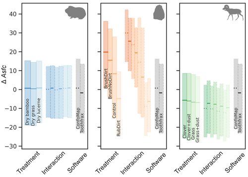
Surface texture analysis in Toothfrax and MountainsMap® SSFA module: Different software packages, different results?An important comparison of software for Scale Sensitive Fractal Analysis : are ancient and new results compatible?Recommended by Alain Queffelec and Florent Rivals based on reviews by Antony Borel and 2 anonymous reviewers
The community of archaeologists, bioanthropologist and paleontologists relying on tools use-wear and dental microwear has grown in the recent years, mainly driven by the spread of confocal microscopes in the laboratories. If the diversity of microscopes is quite high, the main software used for 3D surface texture data analysis are mostly different versions of the same Mountains Map core. In addition to this software, since the beginning of 3D surface texture analysis in dental microwear, surface sensitive fractal analysis (SSFA) initially developed for industrial research (Brown & Savary, 1991) have been performed in our disciplines with the Sfrax/Toothfrax software for two decades (Ungar et al., 2003). This software being discontinued, these calculations have been integrated to the new versions of Mountains Map, with multi-core computing, full integration in the software and an update of the calculation itself. New research based on these standard parameters of surface texture analysis will be, from now on, mainly calculated with this new add-on of Mountains Map, and will be directly compared with the important literature based on the previous software. The question addressed by Calandra et al. (2022), gathering several prominent researchers in this domain including the Mountains Map developer F. Blateyron, is key for the future research: can we directly compare SSFA results from both software? Thanks to a Bayesian approach to this question, and comparing results calculated with both software on three different datasets (two on dental microwear, one on lithic raw materials), the authors show that the two software gives statistically different results for all surface texture parameters tested in the paper. Nevertheless, applying the new calculation to the datasets, they also show that the results published in original studies with these datasets would have been similar. Authors also claim that in the future, researchers will need to re-calculate the fractal parameters of previously published 3D surfaces and cannot simply integrate ancient and new data together. We also want to emphasize the openness of the work published here. All datasets have been published online and will be probably very useful for future methodological works. Authors also published their code for statistical comparison of datasets, and proposed a fully reproducible article that allowed the reviewers to check the content of the paper, which can also make this article of high interest for student training. This article is therefore a very important methodological work for the community, as noted by all three reviewers. It will certainly support the current transition between the two software packages and it is necessary that all surface texture specialists take these results and the recommendation of authors into account: calculate again data from ancient measurements, and share the 3D surface measurements on open access repositories to secure their access in the future. References Brown CA, and Savary G (1991) Describing ground surface texture using contact profilometry and fractal analysis. Wear, 141, 211–226. https://doi.org/10.1016/0043-1648(91)90269-Z Calandra I, Bob K, Merceron G, Blateyron F, Hildebrandt A, Schulz-Kornas E, Souron A, and Winkler DE (2022) Surface texture analysis in Toothfrax and MountainsMap® SSFA module: Different software packages, different results? Zenodo, 7219877, ver. 4 peer-reviewed and recommended by Peer Community in Archaeology. https://doi.org/10.5281/zenodo.7219877 Ungar PS, Brown CA, Bergstrom TS, and Walker A (2003) Quantification of dental microwear by tandem scanning confocal microscopy and scale-sensitive fractal analyses. Scanning: The Journal of Scanning Microscopies, 25, 185–193. https://doi.org/10.1002/sca.4950250405 | Surface texture analysis in Toothfrax and MountainsMap® SSFA module: Different software packages, different results? | Ivan CALANDRA, Konstantin BOB, Gildas MERCERON, François BLATEYRON, Andreas HILDEBRANDT, Ellen SCHULZ-KORNAS, Antoine SOURON, Daniela E. WINKLER | <p>The scale-sensitive fractal analysis (SSFA) of dental microwear textures is traditionally performed using the software Toothfrax. SSFA has been recently integrated to the software MountainsMap® as an optional module. Meanwhile, Toothfrax suppor... | | Computational archaeology, Palaeontology, Traceology | Alain Queffelec | Anonymous, John Charles Willman, Antony Borel | 2022-07-07 09:58:50 |


