Moving away from the ritual deposition: hoards from the Viking Age, Least Cost Paths and reused Roman Roads
Mobility and the reuse of Roman Roads for the deposition of Viking Age silver hoards in North West England
Abstract
Recommendation: posted 06 May 2024, validated 07 May 2024
Visser, R. (2024) Moving away from the ritual deposition: hoards from the Viking Age, Least Cost Paths and reused Roman Roads. Peer Community in Archaeology, 100348. https://doi.org/10.24072/pci.archaeo.100348
Recommendation
I had the pleasure of reading ‘Mobility and the reuse of Roman Roads for the deposition of Viking Age silver hoards in North West England’ by Wyatt O. Wilcox (Wilcox 2024a). It is an honour to recommend this paper. The aim of this study is to research the relationship of 18 Viking Age hoards and their transport and depositional locations. This is studied in relation to the Roman road network and the landscape using least cost path analyses. Single finds from the Portable Antiquities Scheme (https://finds.org.uk/) are also incorporated in the study. The study deals with the distance of these Viking Age finds to these roads/least-cost-paths and the final interpretation moves away from ritual interpretation of these finds to a more mundane explanation. I feel that this could potentially open discussion also for hoards from other periods.
While both reviewers (Sam Leggett and Scott Madry) presented various suggestions to improve the first submitted version of the paper, the author has done a tremendous job to improve the paper based on the comments and even beyond these comments. The author has also deposited the Jypiter-notebook online (Wilcox 2024b), showing that he is contributing to Open Science. The first version of the dataset has been improved and updated based on the comments by the reviewers and me, improving the reproducibility of the analyses. All in all, this paper has improved and I am very glad that I can recommend this for publication, and I’d like to do so with a sentence from the review by Sam Leggett:
“this study has a lot of potential to be deployed across other regions, and time periods for similar purposes (Iron Age hoards for instance). And it will be of great interest to Viking Age experts interested in hoards, but also early medieval transport and travel.”
References
Wilcox, W. 2024a Mobility and the reuse of Roman Roads for the deposition of Viking Age silver hoards in North West England. Zenodo, 7999149, ver. 5 peer-reviewed and recommended by Peer Community in Archaeology. https://doi.org/10.5281/zenodo.7999149
Wilcox, W. 2024b Mobility and the reuse of Roman Roads for the deposition of Viking Age silver hoards in North West England (Supplemental Material). https://doi.org/10.5281/zenodo.11067607

The recommender in charge of the evaluation of the article and the reviewers declared that they have no conflict of interest (as defined in the code of conduct of PCI) with the authors or with the content of the article. The authors declared that they comply with the PCI rule of having no financial conflicts of interest in relation to the content of the article.
The author declares that he has received no specific funding for this study
Evaluation round #1
DOI or URL of the preprint: https://doi.org/10.5281/zenodo.8003663
Version of the preprint: 3
Author's Reply, 27 Apr 2024
Dear Reviewers and CAA editors:
I am very grateful for the valuable feedback provided by the two reviewers and editor on my earlier draft, and thank them for the opportunity to submit a revised draft. I found my feedback constructive and believe that the resulting changes have significantly strengthened this second version of my paper. Overall, both reviewers raised the concern that I needed to justify and explain the GIS methods in the paper for a non-specialist audience, and I have attempted to do this throughout the revised draft. Visser and Leggett both asked for better explanation of colors in the figures. I have not only explained the colors in more detail, but also improved the figure color schemes to Color Vision Deficiency-friendly palettes.
In response to the concerns raised by Scott Madry, I have made these changes:
1. I have included modern photographs of Romano-British routes that illustrate both the extant road construction features and a panorama of the landscapes traversed by the routes. I agree with the reviewer’s assertion that this will have strengthened the paper by giving a sense of landscape and context.
2. I have included a “Future Research” section to suggest further directions of work related to this paper.
3. I have included more detail about the resolution of the OS Terrain 50 DEM in the Materials and Methodology section, and while I have not included an additional figure depicting the resolution, I have now pointed the reader at the Ordinance Survey’s technical specifications manual for the DEM with an in-text citation. The Ordinance Survey technical specifications include multiple three dimensional graphics of the DEM resolution.
In response to concerns raised by Sam Leggett, I have made these changes:
1. I have made numerous grammatical changes in the document and thank Sam for the helpful tracked changes document.
2. I have addressed each content-related concern from the tracked changes document, including the expansion of ritual deposition in the background and an explanation of its implications in the results/discussion.
3. I have better incorporated figures by attempting to illustrate and visually strengthen my argument with appropriate figures. Each figure is called out in the appropriate part of the text.
4. I have used the introduction and abstract to better allude to/advertise the results of the paper.
5. I agreed with the suggestion to cite Tom Horne’s 2021 book A Viking Market Kingdom in Britain and Ireland. I have reproduced one of Horne’s maps with permission and cited his arguments at multiple points, particularly in the background.
6. I agreed with the suggestion to cite Brookes and Huynh (2018) and have cited their work while suggesting an analysis similar to theirs as future research.
7. I have included a feature class of transport nodes in the accompanying supplemental material to enable reproduction of the optimal paths between nodes.
8. I have pointed the reader to the supplemental material data availability earlier in the document.
9. I have removed figures protected by copyright and only included figures that I have obtained permission to use. The appropriate copyright attribution statements are noted in the text, where necessary.
In response to comments made by Ronald Visser, I have made these changes:
1. I have strengthened the metadata of the supplemental material and attached embedded metadata to all GIS layers provided in the data package. I have provided the optimal paths I generated between nodes in order to allow the user to compare the data with their own analysis.
2. I improved the bin widths of Figure 13 to integer values.
Furthermore, I was not able to address some criticisms that were raised during the peer review. I justify each in detail:
1. Sam Leggett suggested that I give as many silver hoard locations as possible in the GIS package as a workaround to the restrictions on grid references to some of the hoards registered with the Portable Antiquities scheme. Unfortunately, I am not able to distribute any of the hoard coordinates I have, as the locations of the hoard not registered with the Portable Antiquities Scheme (PAS) were provided to me on behalf of the Lancashire Historic Environment Record (HER) office. All hoard coordinates I am in possession of are not distributable under my terms of use. The locations of non-PAS hoards can be obtained with permission of the relevant county councils by directly contacting their county HER offices.
2. Sam Leggett and Ronald Visser asked that I make as much optimal path data available as possible. However, I was not able to include the departure points/departure paths GIS data available for the hoards described above because of the same terms of use limitations. I believe that if I provide the departure pathways to the hoard locations, I will violate my terms of use. The method to recreate these pathways is described in the paper’s methods section should any members of the scientific community gain access to the hoard locations and wish to recreate my work.
3. Sam Leggett suggested that I cite the work of Danica Ramsey-Brimberg. I found that Ramsey-Brimberg’s publicly-advertised work was a PhD thesis that was under copyright restriction at the time my second draft was being prepared. Thus, this work was not cited in my second draft.
I very much look forward to hearing from you in due course regarding the second draft.
Best wishes,
Wyatt Wilcox
Decision by Ronald Visser , posted 02 Feb 2024, validated 03 Feb 2024
I had the pleasure of reading ‘Mobility and the reuse of Roman Roads for the deposition of Viking Age silver hoards in North West England’ by Wyatt O. Wilcox (Wilcox 2023a). The aim of this study is to research the relationship of 18 Viking Age hoards and their transport and depositional locations. This is studied in relation to the Roman road network and the landscape using least cost path analyses. Single finds from the Portable Antiquities Scheme (https://finds.org.uk/) are also incorporated in the study. The study deals with the distance of these Viking Age finds to these roads/least-cost-paths and the final interpretation moves away from ritual interpretation of these finds to a more mundane explanation. I feel that this could potentially open discussion also for hoards from other periods.
The author has also deposited the Jypiter-notebook online (Wilcox 2023b), showing that he is contributing to Open Science, although one of the reviewers makes some very keen observations and gives suggestions to do this better. In addition, it would be good to improve the metadata of the files contributed and maybe also include the least-cost path data you have created to improve the reproducibility. Please have a look at standards for sharing data (e.g. Marwick et al. 2017; Marwick and Birch 2018; Wilkinson et al. 2016, 2019) and recently this nice manual was published (Brinkman et al. 2023).
The reviewers present various valuable comments and suggestions to make this paper better and there is no need to repeat their comments, especially since one of the reviewers places detailed comments in the document. To add to their comments: the legends of figures 8,9 and 10 are incomplete, since the colours of the paths is missing. What do these different colours mean? In addition, the bin widths you have chosen in figure 11 are a bit curious, please make them more logical. Both reviewers make excellent points, for example: “With some edits this study has a lot of potential to be deployed across other regions, and time periods for similar purposes (Iron Age hoards for instance). And it will be of great interest to Viking Age experts interested in hoards, but also early medieval transport and travel.” This great compliment is in agreement with the other reviewer: “… I believe this paper is worthy of publication, with minor revisions…”
I am looking forward to read an updated and improved version, with the comments and suggestions of the reviewers incorporated.
References
Brinkman, L, Dijk, E, Jonge, H de, Loorbach, N and Rutten, D. 2023 Open Science: A Practical Guide for Early-Career Researchers DOI: https://doi.org/10.5281/zenodo.7716153.
Marwick, B and Birch, SEP. 2018 A Standard for the Scholarly Citation of Archaeological Data as an Incentive to Data Sharing. Advances in Archaeological Practice 6(2): 125–143. DOI: https://doi.org/10.1017/aap.2018.3.
Marwick, B, d’Alpoim Guedes, J, Barton, CM, Bates, LA, Baxter, M, Bevan, A, Bollwerk, EA, Bocinsky, RK, Brughmans, T, Carter, AK, Conrad, C, Contreras, DA, Costa, S, Crema, ER, Daggett, A, Davies, B, Drake, BL, Dye, TS, France, P, Fullagar, R, Giusti, D, Graham, S, Harris, MD, Hawks, J, Health, S, Huffer, D, Kansa, EC, Kansa, SW, Madsen, ME, Melcher, J, Negre, J, Neiman, FD, Opitz, R, Orton, DC, Przstupa, P, Raviele, M, Riel-Savatore, J, Riris, P, Romanowska, I, Smith, J, Strupler, N, Ullah, II, Van Vlack, HG, VanValkenburgh, N, Watrall, EC, Webster, C, Wells, J, Winters, J and Wren, CD. 2017 Open science in archaeology. SAA Archaeological Record 17(4): 8–14.
Wilcox, WO. 2023a Mobility and the reuse of Roman Roads for the deposition of Viking Age silver hoards in North West England. DOI: https://doi.org/10.5281/zenodo.8003663.
Wilcox, WO. 2023b Mobility and the reuse of Roman Roads for the deposition of Viking Age silver hoards in North West England (Supplemental Material).
Wilkinson, MD, Dumontier, M, Aalbersberg, IjJ, Appleton, G, Axton, M, Baak, A, Blomberg, N, Boiten, J-W, da Silva Santos, LB, Bourne, PE, Bouwman, J, Brookes, AJ, Clark, T, Crosas, M, Dillo, I, Dumon, O, Edmunds, S, Evelo, CT, Finkers, R, Gonzalez-Beltran, A, Gray, AJG, Groth, P, Goble, C, Grethe, JS, Heringa, J, ’t Hoen, PAC, Hooft, R, Kuhn, T, Kok, R, Kok, J, Lusher, SJ, Martone, ME, Mons, A, Packer, AL, Persson, B, Rocca-Serra, P, Roos, M, van Schaik, R, Sansone, S-A, Schultes, E, Sengstag, T, Slater, T, Strawn, G, Swertz, MA, Thompson, M, van der Lei, J, van Mulligen, E, Velterop, J, Waagmeester, A, Wittenburg, P, Wolstencroft, K, Zhao, J and Mons, B. 2016 The FAIR Guiding Principles for scientific data management and stewardship. Scientific Data 3(1): 160018. DOI: https://doi.org/10.1038/sdata.2016.18.
Wilkinson, MD, Dumontier, M, Jan Aalbersberg, I, Appleton, G, Axton, M, Baak, A, Blomberg, N, Boiten, J-W, da Silva Santos, LB, Bourne, PE, Bouwman, J, Brookes, AJ, Clark, T, Crosas, M, Dillo, I, Dumon, O, Edmunds, S, Evelo, CT, Finkers, R, Gonzalez-Beltran, A, Gray, AJG, Groth, P, Goble, C, Grethe, JS, Heringa, J, Hoen, PAC ’t, Hooft, R, Kuhn, T, Kok, R, Kok, J, Lusher, SJ, Martone, ME, Mons, A, Packer, AL, Persson, B, Rocca-Serra, P, Roos, M, van Schaik, R, Sansone, S-A, Schultes, E, Sengstag, T, Slater, T, Strawn, G, Swertz, MA, Thompson, M, van der Lei, J, van Mulligen, E, Jan Velterop, Waagmeester, A, Wittenburg, P, Wolstencroft, K, Zhao, J and Mons, B. 2019 Addendum: The FAIR Guiding Principles for scientific data management and stewardship. Scientific Data 6(1): 6. DOI: https://doi.org/10.1038/s41597-019-0009-6.
Reviewed by Scott Madry, 03 Jul 2023
PCI Archaeology review of the Wyatt O. Wilcox paper by Scott Madry
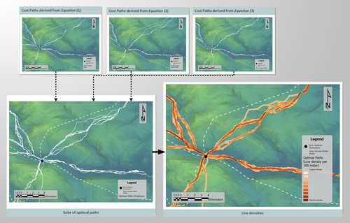
There are two principal questions that are explored in this paper. The first of these is ‘how do the Viking era silver hoards in this region with known locations relate to early medieval period routeways leading away from York’? The second of these questions is ‘can the hoards’ relationships with cross-Pennine routeways be interpreted as a means for concealment away from the routeways’? To answer these questions, a dedicated Geographic Information Systems (GIS) modelling process was developed in ArcGIS Pro 3.0 and this was used, with appropriate data, to model and analyze the spatial relationships of these sites.
The manuscript was well written, and it clearly described the questions and approach of analysis. The title is appropriate, as was the abstract. I did not find any significant problems with the research design or analysis, but some additional explanation of what the analysis was and why the specific GIS analysis models which were used were chosen might be better explained for those who are not familiar with the topic. Also, some additional explanation of the DEM would be appropriate. The DEM used was a ‘A base DEM (OS Terrain-50)‘ but for those of us not from the UK who are not familiar with this product, this should be more clearly described with perhaps a detailed image of a small area in 3-D, so that the quality and resolution of the baseline DEM is more clear to the reader. The data appear to be appropriately analyzed, but I did not run the analysis with their data so I could not test their results myself. The graphics are appropriate and clearly presented. The references were appropriate and relevant.
One recommendation is that I would like to have seen some landscape photographs to get a sense of the nature of the area, particularly any vestiges of the ancient roadways. This would help people not familiar with the study area to better understand the graphics showing the GIS analysis. This does not alter the basics of the paper or analysis, but would help to put the analysis into the context of the current and historical landscape.
My one real recommendation is that there should be a final section which presents the future directions and next steps that either this researcher or others could do to further this thread of technical analysis. What advances were made? What new questions were raised? What would be the next steps to advance the state of the practice? Would LiDAR or other additional data or new approaches in analysis provide better DEM resolution and thus better results? Where could this go from here? A set of recommendations for what these next steps might be would be very helpful to other researchers interested in advancing the same research topic.
There was no misconduct apparent, and I believe this paper is worthy of publication, with minor revisions as stated above.
Reviewed by Sam Leggett, 20 Jul 2023
This is a very interesting and novel study on Viking Age hoards in North West England utilising least cost path GIS models. It focuses on the following aspects:
1. Undertaking more robust LCP/Optimal path analysis (compared with the basic inbuilt ArcGIS functionality) to compare these new LCPs with the Romano-British road network and major early medieval settlement and economic hubs.
2. Using these optimal paths to determine how far “off path” Viking Age hoards are.
3. Interrogating the “off path” times, path/road networks and hoard typology to interrogate long held assumptions and weigh in on the debate surrounding ritual deposition versus intended retrieval for these hoards.
With some edits this study has a lot of potential to be deployed across other regions, and time periods for similar purposes (Iron Age hoards for instance). And it will be of great interest to Viking Age experts interested in hoards, but also early medieval transport and travel.
I’ve detailed my comments in a tracked changes document attached but the key points I want to highlight for further edits are as follows. There are some explanatory steps missing, or ones that need greater expansion, especially as it comes to methods. This is especially true for readers unfamiliar with GIS techniques. I would like to see more justification and explanation of the 3 cost equations used as these are not fully explored in text. Additionally, I know there are some Treasure Trove/PAS restrictions on location data used here, however although some of the scripts and tables are provided on Zenodo, the study isn’t fully replicable, and I think there are ways to work around this and still maintain CARE principles – again further discussion and explanation on this in text would be valuable to readers. Additionally, many of the figures need to be better incorporated into the main text in terms of discussion, and I would caution you to check about copyright rules and regulations around your own photos of museum objects in published works – it’s usually ok for theses/dissertations but not for published articles so worth checking. However, my main recommendation is that throughout the paper there is not enough showing or demonstrating with data and maps/models, most of the study outcomes are simply stated without support from the GIS outputs (which links back to my previous comment about figures in text).
There are some additional literature I would've expected to see engagement with, particularly the work of Tom Horne, Danica Ramsey-Brimberg and Stuart Brookes (see PDF comments for full citations).
In terms of the results (which are interesting!) there could be better “selling” of this as they’re worked into the existing literature in a relatively passive way, and more active engagement with the debate and hyping up of your work is needed – this is better reflected in the conclusions but needs to be more forceful higher up in the text.
Overall, I found this an interesting application of LCP/OP models to Viking Age questions, and will use it as an example for my GIS classes in future.
I've also uploaded detailed comments on the in-line text for the author - see the attached PDF.
Download the review https://doi.org/10.24072/pci.archaeo.100348.rev12


