
Integrating remote sensing and photogrammetric approaches to studying a fortified settlement along the Limes Arabicus: Umm ar‐Rasas (Amman, Jordan).
Study and enhancement of the heritage value of a fortified settlement along the Limes Arabicus. Umm ar-Rasas (Amman, Jordan) between remote sensing analysis, photogrammetry and laser scanner surveys.
Recommendation: posted 22 April 2024, validated 29 April 2024
Brucato, A. (2024) Integrating remote sensing and photogrammetric approaches to studying a fortified settlement along the Limes Arabicus: Umm ar‐Rasas (Amman, Jordan).. Peer Community in Archaeology, 100404. https://doi.org/10.24072/pci.archaeo.100404
Recommendation
Di Palma et alii manuscript delves into applying remote sensing and photogrammetry methods to document and analyze the castrum at the Umm er-Rasas site in Jordan. This research aimed to map all the known archaeological evidence, detect new historical structures, and create a digital archive of the site's features for study and education purposes [1].
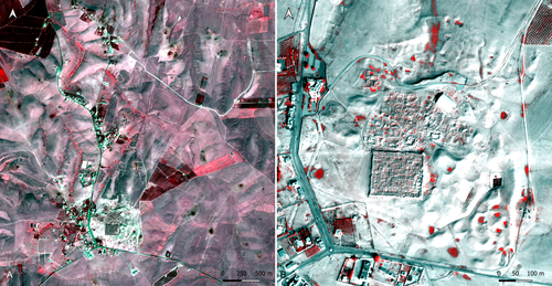
Their research has been organized into two phases. The first one consisted of a remote sensing survey and involved collecting historical and modern aerial and satellite imagery, such as: aerial photographs by Sir Marc Aurel Stein from 1939; panchromatic spy satellite images from the Cold War period (Corona KH-4B and Hexagon KH-9); high and very high resolution (HR and VHR) modern multispectral satellite images (Pléiades-1A and Pléiades Neo-4) [1]. This dataset was processed using the ENVI 4.4 software and applying multiple image-enhancing techniques (Pansharpening, RGB composite, data fusion, and Principal Component Analysis). Then, the resulting images were integrated into a QGIS project, allowing for visual analyses of the site's features and terrain. These investigations provided:
· a broad overview of the site,
· the discovery of a previously unknown archaeological feature (the northeastern dam),
· a stage for targeted ground-level investigations [1].
The project's second phase was dedicated to intensive fieldwork operations, including pedestrian surveys, stratigraphic excavations, and photogrammetric recordings, such as: photographic reconstructions via Structure from Motion (SfM) and laser scanner sessions (using two FARO X330 HDR). In particular, the laser scanner data were processed with Reconstructor 4.4, which provided highly detailed 3D models for the QGIS database. These results were crucial in validating the information acquired during the first phase.
Overall, the paper is well written, with clear objectives and a systematic presentation of the site [2,3,10,11], the research materials, and the study phases. The dataset was described in meticulous detail (especially the remote sensing sources and the laser scanner recordings). The methods implemented in this study are rigorously described [4,5,6,7,8,9] and show a high level of integration between aerial and field techniques. The results are neatly illustrated and fit into the current debates about the efficacy of remote sensing detection and multiscale approaches in archaeological research.
In conclusion, this manuscript significantly contributes to archaeological research, unveiling new and exciting findings about the site of Umm er-Rasas. Its findings and methodologies warrant publication and further exploration.
References:
1. Di Palma, F., Gabrielli, R., Merola, P., Miccoli, I. and Scardozzi, G. (2024). Study and enhancement of the heritage value of a fortified settlement along the Limes Arabicus. Umm ar-Rasas (Amman, Jordan) between remote sensing analysis, photogrammetry and laser scanner surveys. Zenodo, 8306381, ver. 3 peer-reviewed and recommended by Peer Community in Archaeology. https://doi.org/10.5281/zenodo.8306381
2. Abela J. and Acconci A. (1997), Umm al‐Rasas Kastron Mefa’a. Excavation Campaign 1997. Church of St. Paul: northern and southern flanks. Liber Annus, 47, 484‐488.
3. Bujard J. (2008), Kastron Mefaa, un bourg à l'époque byzantine: Travaux de la Mission archéologique de la Fondation Max van Berchem à Umm al‐Rasas, Jordanie (1988‐1997), PhD diss., University of Fribourg 2008.
4. Cozzolino M., Gabrielli R., Galatà P., Gentile V., Greco G., Scopinaro E. (2019), Combined use of 3D metric surveys and non‐invasive geophysical surveys at the stylite tower (Umm ar‐Rasas, Jordan), Annals of geophysics, 62, 3, 1‐9. http://dx.doi.org/10.4401/ag‐8060
5. Gabrielli R., Salvatori A., Lazzari A., Portarena D. (2016), Il sito di Umm ar‐Rasas – Kastron Mefaa – Giordania. Scavare documentare conservare, viaggio nella ricerca archeologica del CNR. Roma 2016, 236‐240.
6. Gabrielli R., Portarena D., Franceschinis M. (2017), Tecniche di documentazione dei tappeti musivi del sito archeologico di Umm al‐Rasas Kastron Mefaa (Giordania). Archeologia e calcolatori, 28 (1), 201‐218. https://doi.org/10.19282/AC.28.1.2017.12
7. Lasaponara R., Masini N. (2012 ed.), Satellite Remote Sensing: A New Tool for Archaeology, New York 2012.
8. Lasaponara R., Masini N. and Scardozzi G. (2007), Immagini satellitari ad alta risoluzione e ricerca archeologica: applicazioni e casi di studio con riprese pancromatiche e multispettrali di QuickBird. Archeologia e Calcolatori, 18 (2), 187‐227. https://core.ac.uk/download/pdf/33150351.pdf
9. Lasaponara R., Masini N., Scardozzi G. (2010), Elaborazioni di immagini satellitari ad alta risoluzione e ricognizione archeologica per la conoscenza degli insediamenti rurali del territorio di Hierapolis di Frigia (Turchia). Il dialogo dei Saperi – Metodologie integrate per i Beni Culturali, Edizioni scientifiche italiane, 479‐494.
10. Piccirillo M., Abela J. and Pappalardo C. (2007), Umm al‐Rasas ‐ campagna 2007. Rapporto di scavo. Liber Annus, 57, 660‐668.
11. Poidebard A. (1934), La trace de Rome dans le désert de Syrie : le limes de Trajan à la conquête arabe ; recherches aériennes 1925 – 1932. Paris : Geuthner.

The recommender in charge of the evaluation of the article and the reviewers declared that they have no conflict of interest (as defined in the code of conduct of PCI) with the authors or with the content of the article. The authors declared that they comply with the PCI rule of having no financial conflicts of interest in relation to the content of the article.
The research in Umm ar-Rasas was supported by the Institute of Heritage Science of the Italian National Research Council (CNR-ISPC) as well as the Italian Ministry of Foreign Affairs.
Evaluation round #1
DOI or URL of the preprint: https://doi.org/10.5281/zenodo.8306382
Version of the preprint: 1
Author's Reply, 22 Apr 2024
Decision by Alessia Brucato, posted 15 Nov 2023, validated 16 Nov 2023
The manuscript under review is generally well presented, focusing on a topic of great interest and a rigorous method.
Overall, the reviews indicate a positive reception of the work, with a consensus on its methodological rigor, commending the integration of remote sensing data with on-the-ground surveys.
The reviewers suggest:
- making the abstract more concise for improved readability;
- incorporating in the materials section other information, like dates, climate, or precipitation records linked to the satellite dataset;
- expanding the investigation on the potential long-term use of the structures of interest;
- proofreading for improved style in some paragraphs, although it is considered non-critical.
Despite these concerns, the manuscript is generally praised for its clear presentation of the research objectives, detailed explanations of methods, and consistent support of findings through remote sensing data and field verification. The reviewers express anticipation for future geophysical survey results and find the references to be more than appropriate.
Reviewed by Francesc C. Conesa, 17 Oct 2023
The manuscript titled "Remote Sensing and Archaeological Survey of Umm ar‐Rasas, Jordan" presents a multi-source geospatial investigation that integrates satellite remote sensing, aerial legacy data, and modern surveying techniques for the identification of the historical topography and construction phases of the fortress and the documentation of several archaeological and ethnographical remains within the study area.
Overall, the manuscript is well-written. It outlines the historical and archaeological significance of the Limes Arabicus and highlights the importance of combining remote sensing data with on-the-ground surveys and field validation. Therefore, I recommend the PCI preprint for further steps in the publication process. However, there are some minor aspects in the text that the authors might address in order to improve the appearance and impact of the final published manuscript.
First, the abstract seems too long (851 words). A short and less detailed abstract would help its lecture. For example, the second paragraph could be moved entirely to the introduction section, which is relatively short and currently only focuses on the site's geographic context, or the following state-of-the-art section.
Secondly, several aerial and satellite historical photographs are used (e.g., Stein archive, Corona, Hegaxon). The acquisition years are indicated in the text, but the complete date of acquisition (e.g., DD-MM-YYYY) is only shown in figures captions or through the text. Perhaps the authors could provide a table with all source and acquisition dates. Such information might be relevant to understand better traditional or long-term land use patterns and seasonal observations that might change from one season to another. This is critical for interpreting the two high-res Pleiades scenes acquired in 2020 and 2022. Perhaps the authors could expand their satellite-based observations with climate or precipitation records for the observed seasons. For example, in line 257 it is mentioned that soils are not excessively dry in October. However, a seasonal or yearly comparison with temperature and precipitation trends in the study area could reinforce this interpretation.
In addition, several archaeological observations are made through visual photointerpretation across the landscape, but little is known about their potential chronological period, such as the irrigated fields, canals, or quarries built in and around the fortress. I wonder whether the authors can expand or elaborate further on the potential long-term use of such structures, as several of those might be linked to the traditional ecological knowledge of the inhabitants till very recent times.
Besides some small comments and typos (see below); I wonder whether the section in line 308 about using laser scanners would better fit under the methods sections to allow for a more comprehensive view of integrating different spatial tools and instruments.
Small comments:
Line 194: "A satellite image is a matrix of numerous pixels, and the value of each is related to the solar energy."; while this statement is generally correct, perhaps the authors could emphasize using multi-spectral optical satellite imagery to differ from other types of satellite acquisition (e.g., from active sensors).
Line 218: an extra “(“ should be removed for better readability of the Pleiades sensor and image properties.
Line 186: image processing was carried out using "specific software". Perhaps the authors could provide a detailed list of the software/tools/versions they used for such analysis. Only ENVI 4.7 is mentioned later in the text (line 235).
Fig.1 -> Figure caption could also indicate the origin of the base maps (e.g., Google or Bing?) and the source of the panchromatic image in b). The same comment applies to Fig. 11.
https://doi.org/10.24072/pci.archaeo.100404.rev11Reviewed by anonymous reviewer 1, 10 Oct 2023
The article deals with the application of remote sensing and photogrammetry methods to the study of the settlement and fort at Umm er-Rasas. The Italian team utilizes state-of-the art methods incorporating both historical and modern satellite imagery, including recently de-classified Hexagon mission. The presentation of methods and results in the first half of the article is made very clear and is well described with sufficient accompanying figures. However, I have some remarks regarding the overall structure of the paper and its aims.
The abstract is too long. Many things are repeated in the introduction (such as history of research) or in the presentation of the methods (such as technical details). I believe that the paper was present at CAA 2023 and the abstract is likely the long abstract submitted to the conference call for papers. If the article is indeed intended for the conference proceedings, then the long abstract might be probably retained? Otherwise, it needs to be significantly reduced and be more concise.
In the introduction I miss very clear and explicit statement regarding the aims and goals of the performed analyses in the context of the project, and especially with its new focus on the fort and the civilian settlement. Overall, what are the intentions of authors with this paper? This problem is again reflected in the discussion which is only very brief and rather presents only plans for the future. If this is supposed to be read as a methodology paper, I am lacking a discussion of the contributions and limitations of the methods employed. If this is supposed to be read as an archaeological-historical paper, I am lacking a thorough discussion focusing on the new findings and how it changes our understanding of the site.
The ‘methods and tools’ and ‘results’ sections are not structured well. The ‘methods’ section is wholly dedicated to the remotely sensed satellite data and their results. Whereas ‘results’ section only very briefly touches on the analysis of the remotely sensed data and then describes methods of laser scanning and photogrammetry survey that were applied. I would suggest to clearly split the methods, the results, and the discussion.
Authors admit that they were not able to present the full results of the photogrammetric survey due to issues with permits from the Department of Antiquities, and so I understand not much can be discussed there. I leave it to the discretion of the authors whether to include the photogrammetric survey in the article, if it cannot be fully presented and discussed. The possible identification of an early fort would deserve a proper presentation and discussion.
I would suggest further English editing, there are couple of paragraphs where style can be improved, but it is not critical.
https://doi.org/10.24072/pci.archaeo.100404.rev12Reviewed by Giuseppe Ceraudo, 14 Nov 2023
In my opinion, the work demonstrates a high level of methodological rigour.
Please see remarks below and minor comments in the pdf attached
Abstract
The abstract is extensive and thorough regarding the discussed topics, yet lacks conciseness.
I recommend summarising it.
Introduction
The introduction presents the archaeological area being studied and the current research state objectively. While the abstract and article provide clear reasons for the research and its issues, I recommend briefly summarising the research objectives in bullet points for clarity and conciseness.
Materials and methods
The methods, materials and tools used in the research are explained in detail in this section of the article.
Results
There is consistency between the remote sensing data analysed and the data verified in the field. The authors include in the results section all the research carried out in the field, including the use of photogrammetry and laser scanning to survey the castrum, which I consider to be consistent with the logical thread of the article.
Tables and figures
The figures are clear and the captions are accurate.
Discussion
The findings are thus adequately supported by the results, and the discourse takes full account of current and previous research. I look forward to the results of the forthcoming geophysical survey.
References
The references are more than appropriate
Download the review https://doi.org/10.24072/pci.archaeo.100404.rev13


