PANAGIOTIDIS Vayia's profile
avatar

PANAGIOTIDIS VayiaORCID_LOGO

  • History, Archaeology and Cultural Resources Management, University of the Peloponnese, Kalamata, Greece
  • Archaeometry, Remote sensing, Spatial analysis

Recommendations:  0

Review:  1

Areas of expertise
Dr. Vayia Panagiotidis, holds a PhD in Digital Application Development in Cultural Heritage and Archaeology. Following 10 years in the private sector she returned to Kalamata to continue her academic studies with the University of the Peloponnese and the Department of History, Archaeology and Cultural Resources Management. She completed her doctorate research in 2021 focusing on the use of Information Technology in Archaeology and Cultural Heritage as well as digital applications of GIS in archaeology. During her collaboration with the Department and the Laboratory of Archaeometry, she has worked on a number of research programs such as the “Kalamata 1821: Roads of Freedom” project for the development of digital applications (AR, WebGIS etc.), the Pylos Geoarchaeological Research Program (survey using UAS, photogrammetry & LiDAR), the Amykles Archaeological Program (survey using UAS, photogrammetry & LiDAR), the Geophysical prospection project of the Amphipolis archaeological project (survey using UAS, photogrammetry & LiDAR). She has also been a member of the Organizing Committee of the 41st International Archaeometry Symposium held in Kalamata Greece in May 2016, the ARCH_RNT Symposium Organizing Committee (2018, 2020, 2022); as week as served as Administrative Officer for the Tourist Guide Intensive Training Program hosted by the University of the Peloponnese in 2016; Administrative Officer for the EU funded “Program for the Acquisition of Academic Teaching Experience for Young Scientists with a PhD” for the academic years 2016-2017 and 2017-2018. Her teaching experience includes lab courses for undergraduates “Specialized Chapter on Archaeometry” (8th semester) and at MSc level “Cultural Heritage Materials & Technologies" Laboratory Practices: Use of Laboratory and Portable Instrumentation, 3D Modelling in CH, AR & VR Applications development for CH as well as the use of UASs in Archaeology with photogrammetry and LiDAR applications. Dr. Panagiotidis is currently a post-doctorate researcher of the Laboratory of Archaeometry responsible for work regarding UAS surveying, GIS applications, Laser Scanning applications, 3D modelling and AR/VR applications. She completed a BSc and MSc degree from the National Technical University of Athens - NTUA (2005) in Applied Mathematics and Physical Sciences. During her studies in NTUA she began program development in Matlab,

Review:  1

02 May 2024
article picture

ARIADNEplus Visual Media Service 3D configurator: toward full guided publication of high-resolution 3D data

ARIADNEplus Visual Media Service 3D configurator: a new tool for the visual organisation of 3D datasets
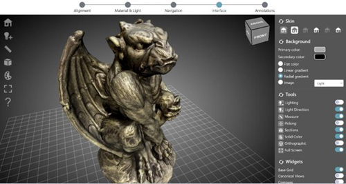
Recommended by based on reviews by Sebastian Hageneuer, Vayia Panagiotidis, Erik Champion and Martina Trognitz

The manuscript "ARIADNEplus Visual Media Service 3D configurator: toward full guided publication of high-resolution 3D data​" by Potenziani et al. [1] provides an excellent introduction to the Visual Media Service 3D Configurator.  This is an exciting tool, focused on cultural heritage, that forms part of the Visual Media Service, a web-based platform for uploading a range of complex data sets, including high-resolution images, Reflectance Transformation Imaging images and 3D models and transforming them into an appropriate format for interation and visualisation on the web.  The 3D Configurator Tool provides researchers with a wizard which assist with the presentation of 3D models.

This manuscript provides a history and context for the development of the Visual Media Service and previous related tools such as 3DHOP, Nexus and Relight/OpenLIME.  It also provides detailed information about the functionality of the 3D Configurator, including the Alignment, Material & Light, Navigation, Interface and Annotation steps.  The Discussion section provides information about applications and users of the Visual Media Service, current limitations and planned future developments.

Reviewers Hageneuer, Champion, Trognitz and Panagiotidis all provided important suggestions to the authors which have improved the clarity and scope of this manuscript.  While this manscript does not present a case study using this tool, I recommend it to readers as a detailed and clear introduction to the Visual Media Service 3D configurator which may inspire them to use this for their own research.

References

[1] Potenziani, M., Ponchio, F., Callieri, M., and Cignoni, P. (2024). ARIADNEplus Visual Media Service 3D configurator: toward full guided publication of high-resolution 3D data. Zenodo, 8075050, ver. 5 peer-reviewed and recommended by Peer Community in Archaeology. https://doi.org/10.5281/zenodo.10894515​

avatar

PANAGIOTIDIS VayiaORCID_LOGO

  • History, Archaeology and Cultural Resources Management, University of the Peloponnese, Kalamata, Greece
  • Archaeometry, Remote sensing, Spatial analysis

Recommendations:  0

Review:  1

Areas of expertise
Dr. Vayia Panagiotidis, holds a PhD in Digital Application Development in Cultural Heritage and Archaeology. Following 10 years in the private sector she returned to Kalamata to continue her academic studies with the University of the Peloponnese and the Department of History, Archaeology and Cultural Resources Management. She completed her doctorate research in 2021 focusing on the use of Information Technology in Archaeology and Cultural Heritage as well as digital applications of GIS in archaeology. During her collaboration with the Department and the Laboratory of Archaeometry, she has worked on a number of research programs such as the “Kalamata 1821: Roads of Freedom” project for the development of digital applications (AR, WebGIS etc.), the Pylos Geoarchaeological Research Program (survey using UAS, photogrammetry & LiDAR), the Amykles Archaeological Program (survey using UAS, photogrammetry & LiDAR), the Geophysical prospection project of the Amphipolis archaeological project (survey using UAS, photogrammetry & LiDAR). She has also been a member of the Organizing Committee of the 41st International Archaeometry Symposium held in Kalamata Greece in May 2016, the ARCH_RNT Symposium Organizing Committee (2018, 2020, 2022); as week as served as Administrative Officer for the Tourist Guide Intensive Training Program hosted by the University of the Peloponnese in 2016; Administrative Officer for the EU funded “Program for the Acquisition of Academic Teaching Experience for Young Scientists with a PhD” for the academic years 2016-2017 and 2017-2018. Her teaching experience includes lab courses for undergraduates “Specialized Chapter on Archaeometry” (8th semester) and at MSc level “Cultural Heritage Materials & Technologies" Laboratory Practices: Use of Laboratory and Portable Instrumentation, 3D Modelling in CH, AR & VR Applications development for CH as well as the use of UASs in Archaeology with photogrammetry and LiDAR applications. Dr. Panagiotidis is currently a post-doctorate researcher of the Laboratory of Archaeometry responsible for work regarding UAS surveying, GIS applications, Laser Scanning applications, 3D modelling and AR/VR applications. She completed a BSc and MSc degree from the National Technical University of Athens - NTUA (2005) in Applied Mathematics and Physical Sciences. During her studies in NTUA she began program development in Matlab,