GARCIA SANCHEZ Jesus
- Instituto de Arqueología de Mérida, CSIC, Mérida, Spain
- Antiquity, Environmental archaeology, Mediterranean, Remote sensing, Spatial analysis
- recommender
Recommendation: 1
Reviews: 0
Recommendation: 1

Underwater Drones as a Low-Cost, yet Powerful Tool for Underwater Archaeological Mapping: Case Studies from the Mediterranean
Underwater drones and semi-automatic SfM, a challenge for underwater archaeology, or are we already there?
Recommended by Jesus Garcia Sanchez based on reviews by Jitte Waagen and 1 anonymous reviewerAnything related to underwater archaeology, either survey, excavation, or documentation processes, poses important challenges that were already once tackled and overcome in ground archaeology. While the archaeological and historical goals of researching the underwater heritage have already been defined and studied in the last decades, i.e. maritime economy, archaeology of harbour constructions, or life within ancient vessels, some of the methodological aspects that we consider normal in the surface are still a matter of concern for underwater archaeologists. Most of these issues are related to a general question: how to acquire geospatial data below the surface. That question related to the problem of acquiring spatial data with GPS data that could be analysed through established tools such as GIS. One could get spatial data with relative positions. However, it has to be inserted in a GIS using a projection.
Drones and GPS are one of the most significant archaeological documentation advances in the last decades. Both systems have become available due to the popularisation of affordable systems and software and the widespread use of GPS for civil uses. Recently, different scholars (Campana, 2017; Stek, 2016; Verhoeven et al., 2021; Waagen, 2019) have elaborated on the use of drones in (Mediterranean) archaeology and beyond. Nevertheless, once one starts working in a completely different setting as underwater archaeology, the need to answer the same methodological questions emerges one more time. How to create digital models of the (sea bottom) surface that could be useful to answer archaeological questions? Those questions could be posed in intra-site contexts (shipwrecks) of “submerged landscape” contexts, like a harbour context, an anchorage area, or a bay used through the past due to favourable conditions.
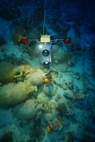
The paper by Diamanti and colleagues (2024) tackles these issues related to drone-based SfM in underwater archaeology. First, they introduced, albeit generally, drone imagery in archaeology to jump into the evolution of drone technology and its applications to marine archaeology. In this section, the main issues regarding the application of drones underwater are familiar to drone practitioners, such as payload capacity, portability, or affordability; other problems are mostly related to underwater devices, such as dive keep, real-time assessment or positioning using USBL (Ultra short baseline).
Diamanti and colleagues present two study cases stemming from an ongoing project conducted in the Phournoi archipelago in the North Aegean Sea, Greece. The first study case is a Late Roman/ Early Byzantine shipwreck, and the second case study is an anchorage area. Both cases are relevant to the paper's overall scope and fit the reader's interest in how to apply underwater drone archaeology in a site context, the shipwreck, and in a broad context/ landscape, the anchorage point. The former a fascinating topic that has been tackled systematically in other areas of the Mediterranean sea (Quevedo et al., 2024)
I won’t explain both cases deeply, but both demonstrate the capabilities of drone-based SfM in underwater contexts. The authors use different devices with different cameras and make an interesting comparison with diver-based 3D models, perhaps the most used method to produce orthophotography of the sea-bottom surface for more than half a century (Drap, 2012; Yamafune et al., 2017). The authors lost a good opportunity to present a more exhaustive comparison of dive-based and drone-based SfM results besides the textual explanation. As a reviewer commented a summary table with camera characteristics and data from the processing results could have given way more depth to that interesting analysis. The authors present a workflow of the process when dealing with complex technological elements, starting with the hardware components such as drones, USBL, and cameras, and the software component of the process, from frame extraction to SfM. This addition contributes to the reproducibility of methodologies, as it is expected from methodological paper as this one. Kudos for that.
In general, Diamani et al.'s paper is a valuable contribution to understanding the impact of drone surveys underwater. It offers information about two relevant study cases that could be used as paradigms for upcoming innovation in underwater archaeology. The recommendation remains to elaborate further on the comparative perspective as the only way to make the research truly innovative.
References
Campana, S., 2017. Drones in Archaeology. State-of-the-art and Future Perspectives. Archaeol. Prospect. 24, 275–296. https://doi.org/10.1002/arp.1569
Diamanti, E., Ødegård, Ø., Mentogiannis, V. and Koutsouflakis, G. (2024) Underwater Drones as a Low-Cost, yet Powerful Tool for Underwater Archaeological Mapping: Case Studies from the Mediterranean. Zenodo, ver.3 peer-reviewed and recommended by PCI Archaeology https://doi.org/10.5281/zenodo.13460949
Drap, P., 2012. Underwater Photogrammetry for Archaeology, in: Special Applications of Photogrammetry. IntechOpen. https://doi.org/10.5772/33999
Quevedo, A., Aragón, E., de Dios Hernández García, J., Rodríguez Pandozi, J., Mukai, T., Segura, A., Bellviure, J. and Muñoz Yesares, R., 2024. Isla del Fraile. Reconstructing Coastal Dynamics in Southeastern Spain Through Underwater Archaeological Survey. Archaeol. Prospect. 31, 149–170. https://doi.org/10.1002/arp.1937
Stek, T., 2016. Drones over Mediterranean landscapes. The potential of small UAV’s (drones) for site detection and heritage management in archaeological survey projects: A case study from Le Pianelle in the Tappino Valley, Molise (Italy). J. Cult. Herit. 1066–1071. https://doi.org/10.1016/j.culher.2016.06.006
Verhoeven, G., Cowley, D. and Traviglia, A., 2021. Archaeological Remote Sensing in the 21st Century: (Re)Defining Practice and Theory. https://doi.org/10.3390/books978-3-0365-1376-8
Waagen, J., 2019. New technology and archaeological practice. Improving the primary archaeological recording process in excavation by means of UAS photogrammetry. J. Archaeol. Sci. 101, 11–20. https://doi.org/10.1016/j.jas.2018.10.011
Yamafune, K., Torres, R. and Castro, F., 2017. Multi-Image Photogrammetry to Record and Reconstruct Underwater Shipwreck Sites. J. Archaeol. Method Theory 24, 703–725. https://doi.org/10.1007/s10816-016-9283-1