
Latest recommendations

| Id | Title | Authors | Abstract | Picture | Thematic fields | Recommender | Reviewers▲ | Submission date | |
|---|---|---|---|---|---|---|---|---|---|
05 Jan 2024
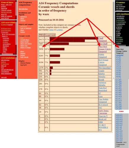
The Density of Types and the Dignity of the Fragment. A Website Approach to Archaeological Typology.Roster and Lexicon – A Radical Digital-Dialogical Approach to Questions of Typology and Categorization in ArchaeologyRecommended by Shumon Tobias Hussain , Felix Riede and Sébastien Plutniak based on reviews by Dominik Hagmann and 2 anonymous reviewers , Felix Riede and Sébastien Plutniak based on reviews by Dominik Hagmann and 2 anonymous reviewers
“The density of types and the dignity of the fragment. A website approach to archaeological typology” by G. Buccellati and M. Kelly-Buccellati (1) is a contribution to the rapidly growing literature on digital approaches to archaeological data management, expertly showcasing the significant theoretical and epistemological impetus of such work. The authors offer a conceptually lucid discussion of key concepts in archaeological ordering practices surrounding the longstanding tension between so-called ‘etic’ and ‘emic’ approaches, thereby providing a thorough systematic of how to think through sameness and difference in the context of voluminous digital archaeological data. As a point of departure, the authors reconsider the relationship between archaeological fragments – spatiotemporally bounded artefacts and features – and their larger meaning-giving totality as the primary locus of archaeological knowledge. Typology can then be said to serve this overriding quest to resolve the conflict between parts and wholes, as the parts themselves are never sufficient to render the whole but the whole remains elusive without reference to the parts. Buccellati and Kelly-Buccellati here make an interesting point about the importance to register the globality of the archaeological record – that is, literally everything encountered in the soil – without making any prior choices as to what supposedly matters and what not. The distinctiveness of the archaeological enterprise, according to them, indeed consists of the circumstance that merely disconnected fragments come to the attention of archaeologists and the only objective data that can be attained, because of this, are about the situated location of fragments in the ground and their relation to other fragments – what they call ‘emplacement’. This, we would add, includes the relationship of fragments with human observers and the employed methods of excavation as observation. As the authors say: “[i]t is in this sense that the fragments are natively digital: they are atoms that do not cohere into a typological whole”. The systematic exploration of how the so recovered fragments may be re-articulated is then essentially the goal of archaeological categorization and typology but these practices can only ever be successful if the whole context of original ‘emplacement’ is carefully taken into consideration. This reconstruction of the fundamental epistemological situation archaeology finds itself in leads the authors to a general rejection of ‘more’ vs. ‘less’ objective or even subjective ordering practices as such qualifications tend to miss the point. What matters is to enable the flexible and scalable confrontation of isolated archaeological fragments, to do experiment with and test different part-whole relations and their possible knowledge contributions. It is no coincidence that the authors insist on a dynamical approach to ordering practices and type-thinking in archaeology here, which in many ways comes often very close to the general conceptual orientation philosopher Stephen C. Pepper (2) has called ‘organicism’ – a preoccupation of resolving the tension between heterogeneous fragments and coherent wholes without losing sight of the specificity of each single fragment. In the view of organicist thinkers, and the authors seem to share this recognition, to take complexity seriously means to centre the dialectics between fragments and wholes in their entirety. This notion is directly reflected in the authors’ interesting definition of ‘big data’ in archaeology as a multi-layered and multi-referential system of organizing the totality of observations of emplacement (the Global record). Based on this broader exposition, Buccellati and Kelly-Buccellati make some perceptive and noteworthy observations vis-à-vis the aforementioned emic-etic distinction that has caused so much archaeological confusion and debate (3–6). To begin with, emic and etic designate different systemic logics of organizing observable sameness and difference. Emic systems are closed and foreground the idea of the roster, they recognize only a limited set of types whose identity depends on relative differences. Etic systems, on the other hand, are in principle open (and even open-ended) and rely on the notion of the lexicon; they enlist a principally endless repertoire of traits, types and sub-types (classes and sub-classes may be added to this list of course). Difference in etic systems is moreover defined according to some general standards that appear to eclipse the standards of the system itself. Etic systems therefore tend to advocate supposedly universal principles of how to establish similarity vs. difference, although, in reality, there is substantial debate as to what these principles may be or whether such endeavour is a useful undertaking. In the wild, both etic and emic systems of ordering and categorization are of course encountered in the plural but etic systems deploy external standards of order while emic systems operate via internal standards. An interesting observation by the authors in this context is that archaeological reasoning in relation to sameness and difference is almost never either exclusively etic or exclusively emic. The simple reason is that any grouping of fragments according to technological (means/modes of production) or functional considerations (use-wear, tool design, relation between form and function) based on empirical evidence is typically already infused by emic standards. The classic example from the analysis of archaeological pottery is ware groups, which reference the nexus of technological know-how and concrete practices, and which rely, in a given context, on internal, relative differentiations between the respective observed practices. Yet ignoring these distinctions would sideline significant knowledge on the past. These discussions are refreshing as they may indicate that ordering practices – when considered as an end in themselves – misconstrue the archaeological process as static and so advocate for categories, classes, and types to be carved out before any serious analysis can begin. It could in fact be argued that in doing so, they merely construct a new closed system, then emic by definition. Buccellati and Kelly-Buccellati propose an alternative without discarding the intuition that ordering archaeological materials is conditional to the inferential and knowledge-production process: they propose that typologies should be treated as arguments. Moreover, the sort of argument they have in mind is to a lesser extent ‘formal-logical’ but instead emphatically ‘dialogical’ in nature, as such argumentative form helps to combat the inherent static-ness of ordering practices the authors criticize, and so discloses a radically dynamic approach to the undertaking of fragment-whole matching. The organicist inclination to preserve ‘the dignity of fragments’ while working towards their resolution in attendant wholes and sub-wholes further gives rise to the idea that such ‘native digital fragments’ must be brought into systematic conversation with one another, acknowledging the involved complexity. To this end, the authors frame ordering work and typo-praxis as a ‘digital discourse’ and ask what the conditions and possibilities for such discourse are and how it can be facilitated. It is here that they put forward the idea that the webpage may provide an ideal epistemic model system to promote the preservation of emplaced archaeological fragments while simultaneously promoting multistranded and multi-context explorations of fragment coherence and articulation. The website enables unique forms of exploration and engagement with data and new arguments escaping the fixity of the analogue-printed which dominates current archaeological practice. Similar experiences were for example made in the context of Gardin’s ‘logicism’, leading to broadly comparable attempts to overcome the analogue with more dynamic, HTML/web-based forms of data presentation, exploration and discussion (7, 8). As such, Buccellati and Kelly-Buccellati table a range of fresh arguments for re-thinking typology beyond and with text at the same time, to enable ‘dynamic reading’ of fragment-whole relationships in an increasingly digital world. Their proposal comes thereby close to what has been termed ‘deep mapping’ in the context of critical cartographies and other spatially-inclined scholarship in the Anglophone world (9, 10). Deep maps seek to transcend the epistemological limitations of 2D-representations of spatiality on traditional maps and introduce different layers of informational depth and heterogeneity, which, similarly to the living digital webpage proposed by the authors, can be continuously extended and revised and which may also greatly promote multidisciplinary and team-based research endeavours. In the same spirit as the authors’ ‘digital discourse’, deep mapping draws attention to the knowledge potential of bringing together the heterogeneous, the etic and the emic, and to pay more attention to ‘multiplanar’ and ‘multilinear’ relationships as well as the associated relations of relations. This proposal to deploy types and typology in general as dynamic arguments is linked to the ambition to contribute to and work on the narrativization of the archaeological record without tacit (and often unconscious) conceptual pre-subscription, countering typologies that remain largely in the abstract and so have contributed to the creeping anonymity of the past.
Bibliography 1. Buccellati, G. and Kelly-Buccellati, M. (2023). The Density of Types and the Dignity of the Fragment. A website approach to archaeological typology, Zenodo, 7743834, ver. 4 peer-reviewed and recommended by Peer Community in Archaeology. https://doi.org/10.5281/zenodo.7743834. 2. Pepper, S C. (1972). World hypotheses: a study in evidence, 7. print (Univ. of California Press). 3. Hayden, B. (1984). Are Emic Types Relevant to Archaeology? Ethnohistory 31, 79–92. https://doi.org/10.2307/482057 4. Tostevin, G. B. (2011). An Introduction to the Special Issue: Reduction Sequence, Chaîne Opératoire, and Other Methods: The Epistemologies of Different Approaches to Lithic Analysis. PaleoAnthropology, 293−296. https://www.doi.org/10.4207/PA.2011.ART59 5. Tostevin, G. B. (2013). Seeing lithics: a middle-range theory for testing for cultural transmission in the pleistocene (Oakville, CT: Oxbow Books). 6. Boissinot, P. (2015). Qu’est-ce qu’un fait archéologique? (Éditions EHESS). https://doi.org/10.4000/lectures.19921 7. Gardin, J.-C. and Roux, V. (2004). The Arkeotek Project: a European Network of Knowledge Bases in the Archaeology of Techniques. Archeologia e Calcolatori 15, 25–40. 8. Husi, P. (2022). La céramique médiévale et moderne du bassin de la Loire moyenne, chrono-typologie et transformation des aires culturelles dans la longue durée (6e—17e s.) (FERACF). 9. Bodenhamer, D. J., Corrigan, J. and Harris, T. M. (2015). Deep Maps and Spatial Narratives (Indiana University Press). 10. Gillings, M., Hacigüzeller, P. and Lock, G. R. (2019). Re-mapping archaeology: critical perspectives, alternative mappings (Routledge).
| The Density of Types and the Dignity of the Fragment. A Website Approach to Archaeological Typology. | Giorgio Buccellati and Marilyn Kelly-Buccellati | <p>Typology hinges on categorization, and the two main axes of categorization are the roster and the lexicon: the first defines elements from an -emic, and the second from an (e)-tic point of view, i. e., as a closed or an open system, respectivel... | | Antiquity, Theoretical archaeology | Shumon Tobias Hussain | 2023-03-17 09:11:46 | ||
04 Oct 2023
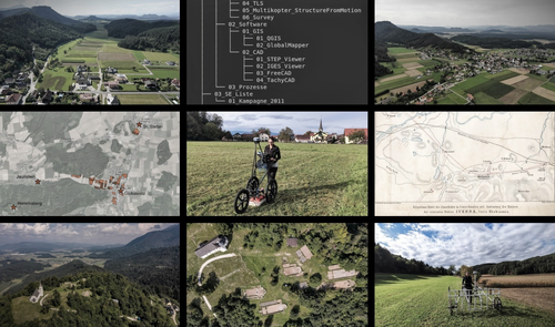
IUENNA – openIng the soUthErn jauNtal as a micro-regioN for future Archaeology: A "para-description"The IUENNA project: integrating old data and documentation for future archaeologyRecommended by Ronald Visser based on reviews by Nina Richards and 3 anonymous reviewers
This recommended paper on the IUENNA project (Hagmann and Reiner 2023) is not a paper in the traditional sense, but it is a reworked version of a project proposal. It is refreshing to read about a project that has just started and see what the aims of the project are. This ties in with several open science ideas and standards (e.g. Brinkman et al. 2023). I am looking forward to see in a few years how the authors managed to reach the aims and goals of the project. The IUENNA project deals with the legacy data and old excavations on the Hemmaberg and in the Jauntal. Archaeological research in this small, but important region, has taken place for more than a century, revealing material from over 2000 years of human history. The Hemmaberg is well known for its late antique and early medieval structures, such as roads, villas and the various churches. The wider Jauntal reveals archaeological finds and features dating from the Iron Age to the recent past. The authors of the paper show the need to make sure that the documentation and data of these past archaeological studies and projects will be accessible in the future, or in their own words: "Acute action is needed to systematically transition these datasets from physical filing cabinets to a sustainable, networked virtual environment for long-term use" (Hagmann and Reiner 2023: 5). The papers clearly shows how this initiative fits within larger developments in both Digital Archaeology and the Digital Humanities. In addition, the project is well grounded within Austrian archaeology. While the project ties in with various international standards and initiatives, such as Ariadne (https://ariadne-infrastructure.eu/) and FAIR-data standards (Wilkinson et al. 2016, 2019), it would benefit from the long experience institutes as the ADS (https://archaeologydataservice.ac.uk/) and DANS (see Data Station Archaeology: https://dans.knaw.nl/en/data-stations/archaeology/) have on the storage of archaeological data. I would also like to suggest to have a look at the Dutch SIKB0102 standard (https://www.sikb.nl/datastandaarden/richtlijnen/sikb0102) for the exchange of archaeological data. The documentation is all in Dutch, but we wrote an English paper a few years back that explains the various concepts (Boasson and Visser 2017). However, these are a minor details or improvements compared to what the authors show in their project proposal. The integration of many standards in the project and the use of open software in a well-defined process is recommendable. The IUENNA project is an ambitious project, which will hopefully lead to better insights, guidelines and workflows on dealing with legacy data or documentation. These lessons will hopefully benefit archaeology as a discipline. This is important, because various (European) countries are dealing with similar problem, since many excavations of the past have never been properly published, digitalized or deposited. In the Netherlands, for example, various projects dealt with publication of legacy excavations in the Odyssee-project (https://www.nwo.nl/onderzoeksprogrammas/odyssee). This has led to the publication of various books and datasets (24) (https://easy.dans.knaw.nl/ui/datasets/id/easy-dataset:34359), but there are still many datasets (8) missing from the various projects. In addition, each project followed their own standards in creating digital data, while IUENNA will make an effort to standardize this. There are still more than 1000 Dutch legacy excavations still waiting to be published and made into a modern dataset (Kleijne 2010) and this is probably the case in many other countries. I sincerely hope that a successful end of IUENNA will be an inspiration for other regions and countries for future safekeeping of legacy data. References Boasson, W and Visser, RM. 2017 SIKB0102: Synchronizing Excavation Data for Preservation and Re-Use. Studies in Digital Heritage 1(2): 206–224. https://doi.org/10.14434/sdh.v1i2.23262 Brinkman, L, Dijk, E, Jonge, H de, Loorbach, N and Rutten, D. 2023 Open Science: A Practical Guide for Early-Career Researchers https://doi.org/10.5281/zenodo.7716153 Hagmann, D and Reiner, F. 2023 IUENNA – openIng the soUthErn jauNtal as a micro-regioN for future Archaeology: A ‘para-description’. https://doi.org/10.31219/osf.io/5vwg8 Kleijne, JP. 2010. Odysee in de breedte. Verslag van het NWO Odyssee programma, kortlopend onderzoek: ‘Odyssee, een oplossing in de breedte: de 1000 onuitgewerkte sites, die tot een substantiële kennisvermeerdering kunnen leiden, digitaal beschikbaar!’ ‐ ODYK‐09‐13. Den Haag: E‐depot Nederlandse Archeologie (EDNA). https://doi.org/10.17026/dans-z25-g4jw Wilkinson, MD, Dumontier, M, Aalbersberg, IjJ, Appleton, G, Axton, M, Baak, A, Blomberg, N, Boiten, J-W, da Silva Santos, LB, Bourne, PE, Bouwman, J, Brookes, AJ, Clark, T, Crosas, M, Dillo, I, Dumon, O, Edmunds, S, Evelo, CT, Finkers, R, Gonzalez-Beltran, A, Gray, AJG, Groth, P, Goble, C, Grethe, JS, Heringa, J, ’t Hoen, PAC, Hooft, R, Kuhn, T, Kok, R, Kok, J, Lusher, SJ, Martone, ME, Mons, A, Packer, AL, Persson, B, Rocca-Serra, P, Roos, M, van Schaik, R, Sansone, S-A, Schultes, E, Sengstag, T, Slater, T, Strawn, G, Swertz, MA, Thompson, M, van der Lei, J, van Mulligen, E, Velterop, J, Waagmeester, A, Wittenburg, P, Wolstencroft, K, Zhao, J and Mons, B. 2016 The FAIR Guiding Principles for scientific data management and stewardship. Scientific Data 3(1): 160018. https://doi.org/10.1038/sdata.2016.18 Wilkinson, MD, Dumontier, M, Jan Aalbersberg, I, Appleton, G, Axton, M, Baak, A, Blomberg, N, Boiten, J-W, da Silva Santos, LB, Bourne, PE, Bouwman, J, Brookes, AJ, Clark, T, Crosas, M, Dillo, I, Dumon, O, Edmunds, S, Evelo, CT, Finkers, R, Gonzalez-Beltran, A, Gray, AJG, Groth, P, Goble, C, Grethe, JS, Heringa, J, Hoen, PAC ’t, Hooft, R, Kuhn, T, Kok, R, Kok, J, Lusher, SJ, Martone, ME, Mons, A, Packer, AL, Persson, B, Rocca-Serra, P, Roos, M, van Schaik, R, Sansone, S-A, Schultes, E, Sengstag, T, Slater, T, Strawn, G, Swertz, MA, Thompson, M, van der Lei, J, van Mulligen, E, Jan Velterop, Waagmeester, A, Wittenburg, P, Wolstencroft, K, Zhao, J and Mons, B. 2019 Addendum: The FAIR Guiding Principles for scientific data management and stewardship. Scientific Data 6(1): 6. https://doi.org/10.1038/s41597-019-0009-6
| IUENNA – openIng the soUthErn jauNtal as a micro-regioN for future Archaeology: A "para-description" | Hagmann, Dominik; Reiner, Franziska | <p>The Go!Digital 3.0 project IUENNA – an acronym for “openIng the soUthErn jauNtal as a micro-regioN for future Archaeology” – embraces a comprehensive open science methodology. It focuses on the archaeological micro-region of the Jauntal Valley ... | | Antiquity, Classic, Computational archaeology | Ronald Visser | 2023-04-06 13:36:16 | ||
02 May 2024
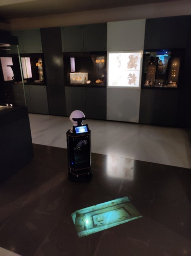
Exploiting RFID Technology and Robotics in the MuseumSocial Robotics in the Museum: a case for human-robot interaction using RFID TechnologyRecommended by Daniel Carvalho based on reviews by Dominik Hagmann, Sebastian Hageneuer and Alexis PantosThe paper “Exploiting RFID Technology and Robotics in the Museum” (Dimitriou et al 2023) is a relevant contribution to museology and an interface between the public, archaeological discourse and the field of social robotics. It deals well with these themes and is concise in its approach, with a strong visual component that helps the reader to understand what is at stake. The option of demonstrating the different steps that lead to the final construction of the robot is appropriate, so that it is understood that it really is a linked process and not simple tasks that have no connection. The use of RFID technology for topological movement of social robots has been continuously developed (e.g., Corrales and Salichs 2009; Turcu and Turcu 2012; Sequeira and Gameiro 2017) and shown to have advantages for these environments. Especially in the context of a museum, with all the necessary precautions to avoid breaching the public's privacy, RFID labels are a viable, low-cost solution, as the authors point out (Dimitriou et al 2023), and, above all, one that does not require the identification of users. It is in itself part of an ambitious project, since the robot performs several functions and not just one, a development compared to other currents within social robotics (see Hellou et al 2022: 1770 for a description of the tasks given to robots in museums). The robotic system itself also makes effective use of the localization system, both physically, by RFID labels and by knowing how to situate itself with the public visiting the museum, adapting to their needs, which is essential for it to be successful (see Gasteiger, Hellou and Ahn 2022: 690 for the theme of localization). Archaeology can provide a threshold of approaches when it comes to social robotics and this project demonstrates that, bringing together elements of interaction, education and mobility in a single method. Hence, this is a paper with great merit and deserves to be recommended as it allows us to think of the museum as a space where humans and non-humans can converge to create intelligible discourses, whether in the historical, archaeological or cultural spheres. References Dimitriou, A. G., Papadopoulou, S., Dermenoudi, M., Moneda, A., Drakaki, V., Malama, A., Filotheou, A., Raptopoulos Chatzistefanou, A., Tzitzis, A., Megalou, S., Siachalou, S., Bletsas, A., Yioultsis, T., Velentza, A. M., Pliasa, S., Fachantidis, N., Tsagkaraki, E., Karolidis, D., Tsoungaris, C., Balafa, P. and Koukouvou, A. (2024). Exploiting RFID Technology and Robotics in the Museum. Zenodo, 7805387, ver. 3 peer-reviewed and recommended by Peer Community in Archaeology. https://doi.org/10.5281/zenodo.7805387 Corrales, A. and Salichs, M.A. (2009). Integration of a RFID System in a Social Robot. In: Kim, JH., et al. Progress in Robotics. FIRA 2009. Communications in Computer and Information Science, vol 44. Springer, Berlin, Heidelberg. https://doi.org/10.1007/978-3-642-03986-7_8 Gasteiger, N., Hellou, M. and Ahn, H.S. (2023). Factors for Personalization and Localization to Optimize Human–Robot Interaction: A Literature Review. Int J of Soc Robotics 15, 689–701. https://doi.org/10.1007/s12369-021-00811-8 Hellou, M., Lim, J., Gasteiger, N., Jang, M. and Ahn, H. (2022). Technical Methods for Social Robots in Museum Settings: An Overview of the Literature. Int J of Soc Robotics 14, 1767–1786 (2022). https://doi.org/10.1007/s12369-022-00904-y Sequeira, J. S., and Gameiro, D. (2017). A Probabilistic Approach to RFID-Based Localization for Human-Robot Interaction in Social Robotics. Electronics, 6(2), 32. MDPI AG. http://dx.doi.org/10.3390/electronics6020032 Turcu, C. and Turcu, C. (2012). The Social Internet of Things and the RFID-based robots. In: IV International Congress on Ultra Modern Telecommunications and Control Systems, St. Petersburg, Russia, 2012, pp. 77-83. https://doi.org/10.1109/ICUMT.2012.6459769 | Exploiting RFID Technology and Robotics in the Museum | Antonis G. Dimitriou, Stella Papadopoulou, Maria Dermenoudi, Angeliki Moneda, Vasiliki Drakaki, Andreana Malama, Alexandros Filotheou, Aristidis Raptopoulos Chatzistefanou, Anastasios Tzitzis, Spyros Megalou, Stavroula Siachalou, Aggelos Bletsas, ... | <p>This paper summarizes the adoption of new technologies in the Archaeological Museum of Thessaloniki, Greece. RFID technology has been adopted. RFID tags have been attached to the artifacts. This allows for several interactions, including tracki... | | Conservation/Museum studies, Remote sensing | Daniel Carvalho | 2023-04-10 14:04:23 | ||
25 Jul 2023
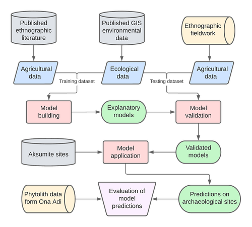
Sorghum and finger millet cultivation during the Aksumite period: insights from ethnoarchaeological modelling and microbotanical analysisAn innovative integration of ethnoarchaeological models with phytolith data to study histories of C4 crop cultivationRecommended by Emma Loftus based on reviews by Tanya Hattingh and 1 anonymous reviewerThis article “Sorghum and finger millet cultivation during the Aksumite period: insights from ethnoarchaeological modelling and microbotanical analysis”, submitted by Ruiz-Giralt and colleagues (2023a), presents an innovative attempt to address the lack of palaeobotanical data concerning ancient agricultural strategies in the northern Horn of Africa. In lieu of well-preserved macrobotanical remains, an especial problem for C4 crop species, these authors leverage microbotanical remains (phytoliths), in combination with ethnoarchaeologically-informed agroecology models to investigate finger millet and sorghum cultivation during the period of the Aksumite Kingdom (c. 50 BCE – 800 CE). Both finger millet and sorghum have played important roles in the subsistence of the Horn region, and throughout much of the rest of Africa and the world in the past. The importance of these drought-resistant and adaptable crops is likely to increase as we move into a warmer, drier world. Yet their histories of cultivation are still only approximately sketched due to a paucity of well-preserved remains from archaeological sites - for example, debate continues as to the precise centre of their domestication. Recent studies of phytoliths (by these and other authors) are demonstrating the likely continuous presence of these crops from the pre-Aksumite period. However, phytoliths are diagnostic only to broad taxonomic levels, and cannot be used to securely identify species. To supplement these observations, Ruiz-Giralt et al. deploy models (previously developed by this team: Ruiz-Giralt et al., 2023b) that incorporate environmental variables and ethnographic data on traditional agrosystems. They evaluate the feasibility of different agricultural regimes around the locations of numerous archaeological sites distributed across the highlands of northern Ethiopia and southern Eritrea. Their results indicate the general viability of finger millet and sorghum cultivation around archaeological settlements in the past, with various regions displaying greater-or-lesser suitability at different distances from the site itself. The models also highlight the likelihood of farmers utilising extensive-rainfed regimes, given low water and soil nutrient requirements for these crops. The authors discuss the results with respect to data on phytolith assemblages, particularly at the site of Ona Adi. They conclude that Aksumite agriculture very likely included the cultivation of finger millet and sorghum, as part of a broader system of rainfed cereal cultivation. Ruiz-Giralt et al. argue, and have demonstrated, that ethnoarchaeologically-informed models can be used to generate hypotheses to be evaluated against archaeological data. The integration of many diverse lines of information in this paper certainly enriches the discussion of agricultural possibilities in the past, and the use of a modelling framework helps to formalise the available hypotheses. However, they emphasise that modelling approaches cannot be pursued in lieu of rigorous archaeobotanical studies but only in tandem - a greater commitment to archaeobotanical sampling is required in the region if we are to fully detail the histories of these important crops. References Ruiz-Giralt, A., Beldados, A., Biagetti, S., D’Agostini, F., D’Andrea, A. C., Meresa, Y. and Lancelotti, C. (2023a). Sorghum and finger millet cultivation during the Aksumite period: insights from ethnoarchaeological modelling and microbotanical analysis. Zenodo, 7859673, ver. 3 peer-reviewed and recommended by Peer Community in Archaeology. https://doi.org/10.5281/zenodo.7859673 Ruiz-Giralt, A., Biagetti, S., Madella, M. and Lancelotti, C. (2023b). Small-scale farming in drylands: New models for resilient practices of millet and sorghum cultivation. PLoS ONE 18, e0268120. https://doi.org/10.1371/journal.pone.0268120
| Sorghum and finger millet cultivation during the Aksumite period: insights from ethnoarchaeological modelling and microbotanical analysis | Abel Ruiz-Giralt, Alemseged Beldados, Stefano Biagetti, Francesca D’Agostini, A. Catherine D’Andrea, Yemane Meresa, Carla Lancelotti | <p>For centuries, finger millet (<em>Eleusine coracana</em> Gaertn.) and sorghum (<em>Sorghum bicolor</em> (L.) Moench) have been two of the most economically important staple crops in the northern Horn of Africa. Nonetheless, their agricultural h... | | Africa, Archaeobotany, Computational archaeology, Protohistory, Spatial analysis | Emma Loftus | 2023-04-29 16:24:54 | ||
02 Sep 2023
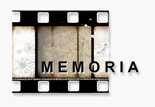
Research workflows, paradata, and information visualisation: feedback on an exploratory integration of issues and practices - MEMORIA ISUsing information visualisation to improve traceability, transmissibility and verifiability in research workflowsRecommended by Isto Huvila based on reviews by Adéla Sobotkova and 2 anonymous reviewersThe paper “Research workflows, paradata, and information visualisation: feedback on an exploratory integration of issues and practices - MEMORIA IS” (Dudek & Blaise, 2023) describes a prototype of an information system developed to improve the traceability, transmissibility and verifiability of archaeological research workflows. A key aspect of the work with MEMORIA is to make research documentation and the workflows underpinning the conducted research more approachable and understandable using a series of visual interfaces that allow users of the system to explore archaeological documentation, including metadata describing the data and paradata that describes its underlying processes. The work of Dudek and Blaise address one of the central barriers to reproducibility and transparency of research data and propose a set of both theoretically and practically well-founded tools and methods to solve this major problem. From the reported work on MEMORIA IS, information visualisation and the proposed tools emerge as an interesting and potentially powerful approach for a major push in improving the traceability, transmissibility and verifiability of research data through making research workflows easier to approach and understand. In comparison to technical work relating to archaeological data management, this paper starts commendably with a careful explication of the conceptual and epistemic underpinnings of the MEMORIA IS both in documentation research, knowledge organisation and information visualisation literature. Rather than being developed on the basis of a set of opaque assumptions, the meticulous description of the MEMORIA IS and its theoretical and technical premises is exemplary in its transparence and richness and has potential for a long-term impact as a part of the body of literature relating to the development of archaeological documentation and documentation tools. While the text is sometimes fairly densely written, it is worth taking the effort to read it through. Another major strength of the paper is that it provides a rich set of examples of the workings of the prototype system that makes it possible to develop a comprehensive understanding of the proposed approaches and assess their validity. As a whole, this paper and the reported work on MEMORIA IS forms a worthy addition to the literature on and practical work for developing critical infrastructures for data documentation, management and access in archaeology. Beyond archaeology and the specific context of the discussed work discussed this paper has obvious relevance to comparable work in other fields. ReferencesDudek, I. and Blaise, J.-Y. (2023) Research workflows, paradata, and information visualisation: feedback on an exploratory integration of issues and practices - MEMORIA IS, Zenodo, 8252923, ver. 3 peer-reviewed and recommended by Peer Community in Archaeology. https://doi.org/10.5281/zenodo.8252923
| Research workflows, paradata, and information visualisation: feedback on an exploratory integration of issues and practices - MEMORIA IS | Dudek Iwona, Blaise Jean-Yves | <p>The paper presents an exploratory web information system developed as a reaction to practical and epistemological questions, in the context of a scientific unit studying the architectural heritage (from both historical sciences perspective, and... | | Computational archaeology | Isto Huvila | 2023-05-02 12:50:39 | ||
12 Feb 2024
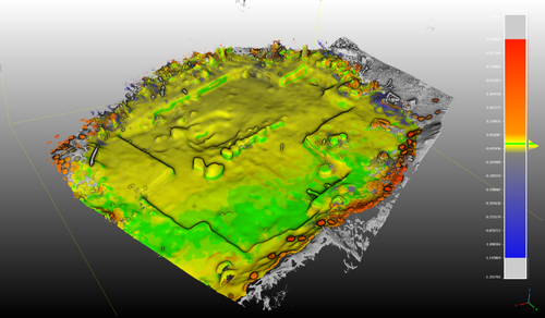
3Duewelsteene - A website for the 3D visualization of the megalithic passage grave Düwelsteene near Heiden in Westphalia, GermanyOnline presentation of the digital reconstruction process of a megalithic tomb : “3Duewelsteene”Recommended by Sophie C. Schmidt and James Allison based on reviews by Robert Bischoff, Ronald Visser and Scott Ure
“3Duewelsteene - A website for the 3D visualization of the megalithic passage grave Düwelsteene near Heiden in Westphalia, Germany” (Tharandt 2024) presents several 3-dimensional models of the Düwelsteene monument, along with contextual information about the grave and the process of creating the models. The website (https://3duewelsteene.github.io/) includes English and German versions, making it accessible to a wide audience. The website itself serves as the primary means of presenting the data, rather than as a supplement to a written text. This is an innovative and engaging way to present the research to a wider public. Düwelsteene (“Devil’s Stones”) is a megalithic passage grave from the Funnel Beaker culture, dating to approximately 3300 BC. to 2600 BC. that was excavated in 1932. The website displays three separate 3-dimensional models. They ares shown in the 3D viewer software 3DHOP, which enables viewers to interact with the models in several ways, Annotations on the models display further information. The first model was created by image-based modeling and shows the monument as it appears today. A second model uses historical photographs and excavation data to reconstruct the grave as it appeared prior to the 1932 archaeological excavation. Restoration work following the excavation relocated many of the stones. Pre-1932 photographs collected from residents of the nearby town of Heiden were then used to create a model showing what the tomb looked like before the restoration work. It is commendable that a “certainty view” of the model shows the certainty with which the stones can be put at the reconstructed place. Gaps in the 3D models of stones that were caused by overlap with other stones have been filled with a rough mesh and marked as such, thereby differentiating between known and unknown parts of the stones. The third model is the most imaginative and most interesting. As it shows as the grave as it might have appeared in approximately 3000 B.C., many aspects of this model are necessarily somewhat speculative. There is no direct evidence for exact size and shape of the capstones, the height of the mound, and other details. But enough is known about other similar constructions to allow these details to be inferred with some confidence. Again, care was taken to enable viewers to distinguish between the stones that are still in existence and those that were reconstructed. A video on the home page of the website adds a nice touch. It starts with the model of the Düwelsteene as it currently appears then shows, in reverse order, the changes to the grave, ending with the inferred original state. The 3D reconstructions are convincing and the methods well described. This project follows an open science approach and the FAIR principles, which is commendable and cutting edge in the field of Digital Archaeology. The preprint of the website hosted on zenodo includes all the photos, text, html files, and nine individual 3D model (.ply) files that are combined in the reconstructions exhibited on the website. A “readme.md” file includes details about building the models using CloudCompare and Blender, and modifications to the 3D viewer software (3DHOP) to get the website to improve the display of the reconstructions. We have to note that the link between the reconstructed models and the html page does not work when the files are downloaded from zenodo and opened offline. The html pages open in the browser, and the individual ply files work fine, but the 3D models do not display on the browser page when the html files are opened offline. The online version of the website is working perfectly. The 3Düwelsteene website combines the presentation of archaeological domain knowledge to a lay audience as well as in-depths information on the reconstruction process to make it an interesting contribution for researchers. By providing data and code for the website it also models an Open Science approach, which enables other researchers to re-use these materials. We congratulate the author on a successful reconstruction of the megalithic tomb, an admirable presentation of the archaeological work and the thoughtful outreach to a broad audience. Bibliography | 3Duewelsteene - A website for the 3D visualization of the megalithic passage grave Düwelsteene near Heiden in Westphalia, Germany | Tharandt, Louise | <p>The Düwelsteene near Heiden, Westphalia, is one of the most southern megalithic tombs of the Funnel Beaker culture. In 1932 the Düwelsteene were restored and the appearance of the grave was changed. Even though the megalithic tomb was excavated... | | Computational archaeology, Mesolithic, Neolithic | Sophie C. Schmidt | 2023-05-21 17:24:22 | ||
02 Sep 2023
Towards a Mobile 3D Documentation Solution. Video Based Photogrammetry and iPhone 12 Pro as Fieldwork Documentation ToolsThe Potential of Mobile 3D Documentation using Video Based Photogrammetry and iPhone 12 ProRecommended by Ying Tung Fung based on reviews by Dominik Hagmann, Sebastian Hageneuer and 1 anonymous reviewerI am pleased to recommend the paper titled "Towards a Mobile 3D Documentation Solution. Video Based Photogrammetry and iPhone 12 Pro as Fieldwork Documentation Tools" for consideration and publication as a preprint (Paukkonen, 2023). The paper addresses a timely and relevant topic within the field of archaeology and offers valuable insights into the evolving landscape of 3D documentation methods. The advances in technology over the past decade have brought about significant changes in archaeological documentation practices. This paper makes a valuable contribution by discussing the emergence of affordable equipment suitable for 3D fieldwork documentation. Given the constraints that many archaeologists face with limited resources and tight timeframes, the comparison between photogrammetry based on a video captured by a DJI Osmo Pocket gimbal camera and iPhone 12 Pro LiDAR scans is of great significance. The research presented in the paper showcases a practical application of these new technologies in the context of a Finnish Early Modern period archaeological project. By comparing the acquisition processes and evaluating the accuracy, precision, ease of use, and time constraints associated with each method, the authors provide a comprehensive assessment of their potential for archaeological fieldwork. This practical approach is a commendable aspect of the paper, as it not only explores the technical aspects but also considers the practical implications for archaeologists on the ground. Furthermore, the paper appropriately addresses the limitations of these technologies, specifically highlighting their potential inadequacy for projects requiring a higher level of precision, such as Neolithic period excavations. This nuanced perspective adds depth to the discussion and provides a realistic portrayal of the strengths and limitations of the new documentation methods. In conclusion, the paper offers valuable insights into the future of 3D field documentation for archaeologists. The authors' thorough evaluation and practical approach make this study a valuable resource for researchers, practitioners, and professionals in the field. I believe that this paper would be an excellent addition to PCIArchaeology and would contribute significantly to the ongoing dialogue within the archaeological community. References Paukkonen, N. (2023) Towards a Mobile 3D Documentation Solution. Video Based Photogrammetry and iPhone 12 Pro as Fieldwork Documentation Tools, Zenodo, 8281263, ver. 3 peer-reviewed and recommended by Peer Community in Archaeology. https://doi.org/10.5281/zenodo.8281263 | Towards a Mobile 3D Documentation Solution. Video Based Photogrammetry and iPhone 12 Pro as Fieldwork Documentation Tools | Nikolai Paukkonen | <p>New affordable equipment suitable for 3D fieldwork documentation has appeared during the last years. Both photogrammetry and laser scanning are becoming affordable for archaeologists, who often work with limited resources and tight time constra... | | Europe, Post-medieval, Remote sensing | Ying Tung Fung | 2023-05-21 21:32:33 | ||
23 Nov 2023
Percolation Package - From script sharing to package publicationSharing Research Code in ArchaeologyRecommended by James Allison based on reviews by Thomas Rose, Joe Roe and 1 anonymous reviewer
The paper “Percolation Package – From Script Sharing to Package Publication” by Sophie C. Schmidt and Simon Maddison (2023) describes the development of an R package designed to apply Percolation Analysis to archaeological spatial data. In an earlier publication, Maddison and Schmidt (2020) describe Percolation Analysis and provide case studies that demonstrate its usefulness at different spatial scales. In the current paper, the authors use their experience collaborating to develop the R package as part of a broader argument for the importance of code sharing to the research process. The paper begins by describing the development process of the R package, beginning with borrowing code from a geographer, refining it to fit archaeological case studies, and then collaborating to further refine and systematize the code into an R package that is more easily reusable by other researchers. As the review by Joe Roe noted, a strength of the paper is “presenting the development process as it actually happens rather than in an idealized form.” The authors also include a section about the lessons learned from their experience. Moving on from the anecdotal data of their own experience, the authors also explore code sharing practices in archaeology by briefly examining two datasets. One dataset comes from “open-archaeo” (https://open-archaeo.info/), an on-line list of open-source archaeological software maintained by Zack Batist. The other dataset includes articles published between 2018 and 2023 in the Journal of Computer Applications in Archaeology. Schmidt and Maddison find that these two datasets provide contrasting views of code sharing in archaeology: many of the resources in the open-archaeo list are housed on Github, lack persistent object identifiers, and many are not easily findable (other than through the open-archaeo list). Research software attached to the published articles, on the other hand, is more easily findable either as a supplement to the published article, or in a repository with a DOI. The examination of code sharing in archaeology through these two datasets is preliminary and incomplete, but it does show that further research into archaeologists’ code-writing and code-sharing practices could be useful. Archaeologists often create software tools to facilitate their research, but how often? How often is research software shared with published articles? How much attention is given to documentation or making the software usable for other researchers? What are best (or good) practices for sharing code to make it findable and usable? Schmidt and Maddison’s paper provides partial answers to these questions, but a more thorough study of code sharing in archaeology would be useful. Differences among journals in how often they publish articles with shared code, or the effects of age, gender, nationality, or context of employment on attitudes toward code sharing seem like obvious factors for a future study to consider. Shared code that is easy to find and easy to use benefits the researchers who adopt code written by others, but code authors also have much to gain by sharing. Properly shared code becomes a citable research product, and the act of code sharing can lead to productive research collaborations, as Schmidt and Maddison describe from their own experience. The strength of this paper is the attention it brings to current code-sharing practices in archaeology. I hope the paper will also help improve code sharing in archaeology by inspiring more archaeologists to share their research code so other researchers can find and use (and cite) it. References Maddison, M.S. and Schmidt, S.C. (2020). Percolation Analysis – Archaeological Applications at Widely Different Spatial Scales. Journal of Computer Applications in Archaeology, 3(1), p.269–287. https://doi.org/10.5334/jcaa.54 Schmidt, S. C., and Maddison, M. S. (2023). Percolation Package - From script sharing to package publication, Zenodo, 7966497, ver. 3 peer-reviewed and recommended by Peer Community in Archaeology. https://doi.org/10.5281/zenodo.7966497 | Percolation Package - From script sharing to package publication | Sophie C Schmidt; Simon Maddison | <p>In this paper we trace the development of an R-package starting with the adaptation of code from a different field, via scripts shared between colleagues, to a published package that is being successfully used by researchers world-wide. Our aim... | | Computational archaeology | James Allison | 2023-05-24 15:40:15 | ||
06 Aug 2023
A Focus on the Future of our Tiny Piece of the Past: Digital Archiving of a Long-term Multi-participant Regional ProjectA meticulous description of archiving research data from a long-running landscape research projectRecommended by Isto Huvila based on reviews by Dominik Hagmann and Iwona DudekThe paper “A Focus on the Future of our Tiny Piece of the Past: Digital Archiving of a Long-term Multi-participant Regional Project” (Madry et al., 2023) describes practices, challenges and opportunities encountered in digital archiving of a landscape research project running in Burgundy, France for more than 45 years. As an unusually long-running multi-disciplinary undertaking working with a large variety of multi-modal digital and non-digital data, the Burgundy project has lived through the development of documentation and archiving technologies from the 1970s until today and faced many of the challenges relating to data management, preservation and migration. The major strenght of the paper is that it provides a detailed description of the evolution of digital data archiving practices in the project including considerations about why some approaches were tested and abandoned. This differs from much of the earlier literature where it has been more common to describe individual solutions how digital archiving was either planned or was performed at one point of time. A longitudinal description of what was planned, how and why it has worked or failed so far, as described in the paper, provides important insights in the everyday hurdles and ways forward in digital archiving. As a description of a digital archiving initiative, the paper makes a valuable contribution for the data archiving scholarship as a case description of practices and considerations in one research project. For anyone working with data management in a research project either as a researcher or data manager, the text provides useful advice on important practical matters to consider ahead, during and after the project. The main advice the authors are giving, is to plan and act for data preservation from the beginning of the project rather than doing it afterwards. To succeed in this, it is crucial to be knowledgeable of the key concepts of data management—such as “digital data fixity, redundant backups, paradata, metadata, and appropriate keywords” as the authors underline—including their rationale and practical implications. The paper shows also that when and if unexpected issues raise, it is important to be open for different alternatives, explore ways forward, and in general be flexible. The paper makes also a timely contribution to the discussion started at the session “Archiving information on archaeological practices and work in the digital environment: workflows, paradata and beyond” at the Computer Applications and Quantitative 2023 conference in Amsterdam where it was first presented. It underlines the importance of understanding and communicating the premises and practices of how data was collected (and made) and used in research for successful digital archiving, and the similar pertinence of documenting digital archiving processes to secure the keeping, preservation and effective reuse of digital archives possible. ReferencesMadry, S., Jansen, G., Murray, S., Jones, E., Willcoxon, L. and Alhashem, E. (2023) A Focus on the Future of our Tiny Piece of the Past: Digital Archiving of a Long-term Multi-participant Regional Project, Zenodo, 7967035, ver. 3 peer-reviewed and recommended by Peer Community in Archaeology. https://doi.org/10.5281/zenodo.7967035 | A Focus on the Future of our Tiny Piece of the Past: Digital Archiving of a Long-term Multi-participant Regional Project | Scott Madry, Gregory Jansen, Seth Murray, Elizabeth Jones, Lia Willcoxon, Ebtihal Alhashem | <p>This paper will consider the practical realities that have been encountered while seeking to create a usable Digital Archiving system of a long-term and multi-participant research project. The lead author has been involved in archaeologic... | | Computational archaeology, Environmental archaeology, Landscape archaeology | Isto Huvila | 2023-05-24 18:46:34 | ||
31 Jan 2024
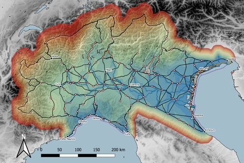
Rivers vs. Roads? A route network model of transport infrastructure in Northern Italy during the Roman periodModelling Roman Transport Infrastructure in Northern ItalyRecommended by Andrew McLean based on reviews by Pau de Soto and Adam PažoutStudies of the economy of the Roman Empire have become increasingly interdisciplinary and nuanced in recent years, allowing the discipline to make great strides in data collection and importantly in the methods through which this increasing volume of data can be effectively and meaningfully analysed [see for example 1 and 2]. One of the key aspects of modelling the ancient economy is understanding movement and transport costs, and how these facilitated trade, communication and economic development. With archaeologists adopting more computational techniques and utilising GIS analysis beyond simply creating maps for simple visualisation, understanding and modelling the costs of traversing archaeological landscapes has become a much more fruitful avenue of research. Classical archaeologists are often slower to adopt these new computational techniques than others in the discipline. This is despite (or perhaps due to) the huge wealth of data available and the long period of time over which the Roman economy developed, thrived and evolved. This all means that the Roman Empire is a particularly useful proving ground for testing and perfecting new methodological developments, as well as being a particularly informative period of study for understanding ancient human behaviour more broadly. This paper by Page [3] then, is well placed and part of a much needed and growing trend of Roman archaeologists adopting these computational approaches in their research. Page’s methodology builds upon De Soto’s earlier modelling of transport costs [4] and applies it in a new setting. This reflects an important practice which should be more widely adopted in archaeology. That of using existing, well documented methodologies in new contexts to offer wider comparisons. This allows existing methodologies to be perfected and tested more robustly without reinventing the wheel. Page does all this well, and not only builds upon De Soto’s work, but does so using a case study that is particularly interesting with convincing and significant results. As Page highlights, Northern Italy is often thought of as relatively isolated in terms of economic exchange and transport, largely due to the distance from the sea and the barriers posed by the Alps and Apennines. However, in analysing this region, and not taking such presumptions for granted, Page quite convincingly shows that the waterways of the region played an important role in bringing down the cost of transport and allowed the region to be far more interconnected with the wider Roman world than previous studies have assumed. This article is clearly a valuable and important contribution to our understanding of computational methods in archaeology as well as the economy and transport network of the Roman Empire. The article utilises innovative techniques to model transport in an area of the Roman Empire that is often overlooked, with the economic isolation of the area taken for granted. Having high quality research such as this specifically analysing the region using the most current methodologies is of great importance. Furthermore, developing and improving methodologies like this allow for different regions and case studies to be analysed and directly compared, in a way that more traditional analyses simply cannot do. As such, Page has demonstrated the importance of reanalysing traditional assumptions using the new data and analyses now available to archaeologists. References [1] Brughmans, T. and Wilson, A. (eds.) (2022). Simulating Roman Economies: Theories, Methods, and Computational Models. Oxford. [2] Dodd, E.K. and Van Limbergen, D. (eds.) (2024). Methods in Ancient Wine Archaeology: Scientific Approaches in Roman Contexts. London ; New York. [3] Page, J. (2024). Rivers vs. Roads? A route network model of transport infrastructure in Northern Italy during the Roman period, Zenodo, 7971399, ver. 3 peer-reviewed and recommended by Peer Community in Archaeology. https://doi.org/10.5281/zenodo.7971399 [4] De Soto P (2019). Network Analysis to Model and Analyse Roman Transport and Mobility. In: Finding the Limits of the Limes. Modelling Demography, Economy and Transport on the Edge of the Roman Empire. Ed. by Verhagen P, Joyce J, and Groenhuijzen M. Springer Open Access, pp. 271–90. https://doi.org/10.1007/978-3-030-04576-0_13 | Rivers vs. Roads? A route network model of transport infrastructure in Northern Italy during the Roman period | James Page | <p>Northern Italy has often been characterised as an isolated and marginal area during the Roman period, a region constricted by mountain ranges and its distance from major shipping lanes. Historians have frequently cited these obstacles, alongsid... | | Classic, Computational archaeology | Andrew McLean | 2023-05-28 15:11:31 |


