Latest recommendations

| Id | Title * | Authors * | Abstract * | Picture * | Thematic fields * ▲ | Recommender | Reviewers | Submission date | |
|---|---|---|---|---|---|---|---|---|---|
02 Sep 2023

Research workflows, paradata, and information visualisation: feedback on an exploratory integration of issues and practices - MEMORIA ISUsing information visualisation to improve traceability, transmissibility and verifiability in research workflowsRecommended by Isto Huvila based on reviews by Adéla Sobotkova and 2 anonymous reviewersThe paper “Research workflows, paradata, and information visualisation: feedback on an exploratory integration of issues and practices - MEMORIA IS” (Dudek & Blaise, 2023) describes a prototype of an information system developed to improve the traceability, transmissibility and verifiability of archaeological research workflows. A key aspect of the work with MEMORIA is to make research documentation and the workflows underpinning the conducted research more approachable and understandable using a series of visual interfaces that allow users of the system to explore archaeological documentation, including metadata describing the data and paradata that describes its underlying processes. The work of Dudek and Blaise address one of the central barriers to reproducibility and transparency of research data and propose a set of both theoretically and practically well-founded tools and methods to solve this major problem. From the reported work on MEMORIA IS, information visualisation and the proposed tools emerge as an interesting and potentially powerful approach for a major push in improving the traceability, transmissibility and verifiability of research data through making research workflows easier to approach and understand. In comparison to technical work relating to archaeological data management, this paper starts commendably with a careful explication of the conceptual and epistemic underpinnings of the MEMORIA IS both in documentation research, knowledge organisation and information visualisation literature. Rather than being developed on the basis of a set of opaque assumptions, the meticulous description of the MEMORIA IS and its theoretical and technical premises is exemplary in its transparence and richness and has potential for a long-term impact as a part of the body of literature relating to the development of archaeological documentation and documentation tools. While the text is sometimes fairly densely written, it is worth taking the effort to read it through. Another major strength of the paper is that it provides a rich set of examples of the workings of the prototype system that makes it possible to develop a comprehensive understanding of the proposed approaches and assess their validity. As a whole, this paper and the reported work on MEMORIA IS forms a worthy addition to the literature on and practical work for developing critical infrastructures for data documentation, management and access in archaeology. Beyond archaeology and the specific context of the discussed work discussed this paper has obvious relevance to comparable work in other fields. ReferencesDudek, I. and Blaise, J.-Y. (2023) Research workflows, paradata, and information visualisation: feedback on an exploratory integration of issues and practices - MEMORIA IS, Zenodo, 8252923, ver. 3 peer-reviewed and recommended by Peer Community in Archaeology. https://doi.org/10.5281/zenodo.8252923
| Research workflows, paradata, and information visualisation: feedback on an exploratory integration of issues and practices - MEMORIA IS | Dudek Iwona, Blaise Jean-Yves | <p>The paper presents an exploratory web information system developed as a reaction to practical and epistemological questions, in the context of a scientific unit studying the architectural heritage (from both historical sciences perspective, and... | | Computational archaeology | Isto Huvila | 2023-05-02 12:50:39 | ||
23 Nov 2023
Percolation Package - From script sharing to package publicationSharing Research Code in ArchaeologyRecommended by James Allison based on reviews by Thomas Rose, Joe Roe and 1 anonymous reviewer based on reviews by Thomas Rose, Joe Roe and 1 anonymous reviewer
The paper “Percolation Package – From Script Sharing to Package Publication” by Sophie C. Schmidt and Simon Maddison (2023) describes the development of an R package designed to apply Percolation Analysis to archaeological spatial data. In an earlier publication, Maddison and Schmidt (2020) describe Percolation Analysis and provide case studies that demonstrate its usefulness at different spatial scales. In the current paper, the authors use their experience collaborating to develop the R package as part of a broader argument for the importance of code sharing to the research process. The paper begins by describing the development process of the R package, beginning with borrowing code from a geographer, refining it to fit archaeological case studies, and then collaborating to further refine and systematize the code into an R package that is more easily reusable by other researchers. As the review by Joe Roe noted, a strength of the paper is “presenting the development process as it actually happens rather than in an idealized form.” The authors also include a section about the lessons learned from their experience. Moving on from the anecdotal data of their own experience, the authors also explore code sharing practices in archaeology by briefly examining two datasets. One dataset comes from “open-archaeo” (https://open-archaeo.info/), an on-line list of open-source archaeological software maintained by Zack Batist. The other dataset includes articles published between 2018 and 2023 in the Journal of Computer Applications in Archaeology. Schmidt and Maddison find that these two datasets provide contrasting views of code sharing in archaeology: many of the resources in the open-archaeo list are housed on Github, lack persistent object identifiers, and many are not easily findable (other than through the open-archaeo list). Research software attached to the published articles, on the other hand, is more easily findable either as a supplement to the published article, or in a repository with a DOI. The examination of code sharing in archaeology through these two datasets is preliminary and incomplete, but it does show that further research into archaeologists’ code-writing and code-sharing practices could be useful. Archaeologists often create software tools to facilitate their research, but how often? How often is research software shared with published articles? How much attention is given to documentation or making the software usable for other researchers? What are best (or good) practices for sharing code to make it findable and usable? Schmidt and Maddison’s paper provides partial answers to these questions, but a more thorough study of code sharing in archaeology would be useful. Differences among journals in how often they publish articles with shared code, or the effects of age, gender, nationality, or context of employment on attitudes toward code sharing seem like obvious factors for a future study to consider. Shared code that is easy to find and easy to use benefits the researchers who adopt code written by others, but code authors also have much to gain by sharing. Properly shared code becomes a citable research product, and the act of code sharing can lead to productive research collaborations, as Schmidt and Maddison describe from their own experience. The strength of this paper is the attention it brings to current code-sharing practices in archaeology. I hope the paper will also help improve code sharing in archaeology by inspiring more archaeologists to share their research code so other researchers can find and use (and cite) it. References Maddison, M.S. and Schmidt, S.C. (2020). Percolation Analysis – Archaeological Applications at Widely Different Spatial Scales. Journal of Computer Applications in Archaeology, 3(1), p.269–287. https://doi.org/10.5334/jcaa.54 Schmidt, S. C., and Maddison, M. S. (2023). Percolation Package - From script sharing to package publication, Zenodo, 7966497, ver. 3 peer-reviewed and recommended by Peer Community in Archaeology. https://doi.org/10.5281/zenodo.7966497 | Percolation Package - From script sharing to package publication | Sophie C Schmidt; Simon Maddison | <p>In this paper we trace the development of an R-package starting with the adaptation of code from a different field, via scripts shared between colleagues, to a published package that is being successfully used by researchers world-wide. Our aim... | | Computational archaeology | James Allison | 2023-05-24 15:40:15 | ||
05 Jan 2024
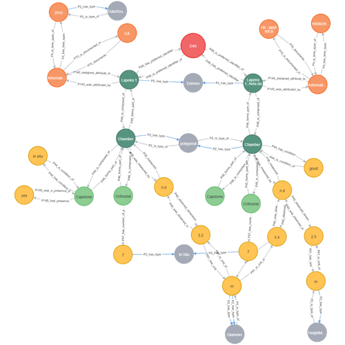
Transforming the CIDOC-CRM model into a megalithic monument property graphInformative description of a project implementing a CIDOC-CRM based native graph database for representing megalithic informationRecommended by Isto Huvila based on reviews by 2 anonymous reviewersThe paper “Transforming the CIDOC-CRM model into a megalithic monument property graph” describes an interesting endeavour of developing and implementing a CIDOC-CRM based knowledge graph using a native graph database (Neo4J) to represent megalithic information (Câmara et al. 2023). While there are earlier examples of using native graph databases and CIDOC-CRM in diverse heritage contexts, the present paper is useful addition to the literature as a detailed description of an implementation in the context of megalithic heritage. The paper provides a demonstration of a working implementation, and guidance for future projects. The described project is also documented to an extent that the paper will open up interesting opportunities to compare the approach to previous and forthcoming implementations. The same applies to the knowledge graph and use of CIDOC-CRM in the project. Readers interested in comparing available technologies and those who are developing their own knowledge graphs might have benefited of a more detailed description of the work in relation to the current state-of-the-art and what the use of a native graph database in the built-heritage contexts implies in practice for heritage documentation beyond that it is possible and it has potentially meaningful performance-related advantages. While also the reasons to rely on using plain CIDOC-CRM instead of extensions could have been discussed in more detail, the approach demonstrates how the plain CIDOC-CRM provides a good starting point to satisfy many heritage documentation needs. As a whole, the shortcomings relating to positioning the work to the state-of-the-art and reflecting and discussing design choices do not reduce the value of the paper as a valuable case description for those interested in the use of native graph databases and CIDOC-CRM in heritage documentation in general and the documentation of megalithic heritage in particular. ReferencesCâmara, A., de Almeida, A. and Oliveira, J. (2023). Transforming the CIDOC-CRM model into a megalithic monument property graph, Zenodo, 7981230, ver. 4 peer-reviewed and recommended by Peer Community in Archaeology. https://doi.org/10.5281/zenodo.7981230 | Transforming the CIDOC-CRM model into a megalithic monument property graph | Ariele Câmara, Ana de Almeida, João Oliveira | <p>This paper presents a method to store information about megalithic monuments' building components as graph nodes in a knowledge graph (KG). As a case study we analyse the dolmens from the region of Pavia (Portugal). To build the KG, information... | | Computational archaeology | Isto Huvila | 2023-05-29 13:46:49 | ||
02 May 2024
ARIADNEplus Visual Media Service 3D configurator: toward full guided publication of high-resolution 3D dataARIADNEplus Visual Media Service 3D configurator: a new tool for the visual organisation of 3D datasetsRecommended by Ian Moffat based on reviews by Sebastian Hageneuer, Vayia Panagiotidis, Erik Champion and Martina Trognitz
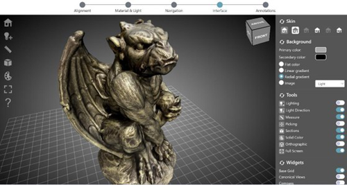
The manuscript "ARIADNEplus Visual Media Service 3D configurator: toward full guided publication of high-resolution 3D data" by Potenziani et al. [1] provides an excellent introduction to the Visual Media Service 3D Configurator. This is an exciting tool, focused on cultural heritage, that forms part of the Visual Media Service, a web-based platform for uploading a range of complex data sets, including high-resolution images, Reflectance Transformation Imaging images and 3D models and transforming them into an appropriate format for interation and visualisation on the web. The 3D Configurator Tool provides researchers with a wizard which assist with the presentation of 3D models. This manuscript provides a history and context for the development of the Visual Media Service and previous related tools such as 3DHOP, Nexus and Relight/OpenLIME. It also provides detailed information about the functionality of the 3D Configurator, including the Alignment, Material & Light, Navigation, Interface and Annotation steps. The Discussion section provides information about applications and users of the Visual Media Service, current limitations and planned future developments. Reviewers Hageneuer, Champion, Trognitz and Panagiotidis all provided important suggestions to the authors which have improved the clarity and scope of this manuscript. While this manscript does not present a case study using this tool, I recommend it to readers as a detailed and clear introduction to the Visual Media Service 3D configurator which may inspire them to use this for their own research. [1] Potenziani, M., Ponchio, F., Callieri, M., and Cignoni, P. (2024). ARIADNEplus Visual Media Service 3D configurator: toward full guided publication of high-resolution 3D data. Zenodo, 8075050, ver. 5 peer-reviewed and recommended by Peer Community in Archaeology. https://doi.org/10.5281/zenodo.10894515 | ARIADNEplus Visual Media Service 3D configurator: toward full guided publication of high-resolution 3D data | Potenziani, Marco; Ponchio, Federico; Callieri, Marco; Cignoni, Paolo | <p>The use of digital visual media in everyday work is nowadays a common practice in many different domains, including Cultural Heritage (CH). Because of that, the presence of digital datasets in CH archives and repositories is becoming more and m... | | Computational archaeology | Ian Moffat | 2023-06-23 17:37:47 | ||
28 Feb 2024

Archaeology specific BERT models for English, German, and DutchMultilingual Named Entity Recognition in archaeology: an approach based on deep learningRecommended by Maria Pia di Buono based on reviews by Shawn Graham and 2 anonymous reviewers
Archaeology specific BERT models for English, German, and Dutch” (Brandsen 2024) explores the use of BERT-based models for Named Entity Recognition (NER) in archaeology across three languages: English, German, and Dutch. It introduces six models trained and fine-tuned on archaeological literature, followed by the presentation and evaluation of three models specifically tailored for NER tasks. The focus on multilingualism enhances the applicability of the research, while the meticulous evaluation using standard metrics demonstrates a rigorous methodology. The introduction of NER for extracting concepts from literature is intriguing, while the provision of a method for others to contribute to BERT model pre-training enhances collaborative research efforts. The innovative use of BERT models to contextualize archaeological data is a notable strength, bridging the gap between digitized information and computational models. Additionally, the paper's release of fine-tuned models and consideration of environmental implications add further value. In summary, the paper contributes significantly to the task of NER in archaeology, filling a crucial gap and providing foundational tools for data mining and reevaluating legacy archaeological materials and archives. Reference Brandsen, A. (2024). Archaeology specific BERT models for English, German, and Dutch. Zenodo, 8296920, ver. 5 peer-reviewed and recommended by Peer Community in Archaeology. https://doi.org/10.5281/zenodo.8296920 | Archaeology specific BERT models for English, German, and Dutch | Alex Brandsen | <p>This short paper describes a collection of BERT models for the archaeology domain. We took existing language specific BERT models in English, German, and Dutch, and further pre-trained them with archaeology specific training data. We then took ... | | Computational archaeology | Maria Pia di Buono | 2023-08-29 14:50:21 | ||
16 Apr 2024
Creating an Additional Class Layer with Machine Learning to counter Overfitting in an Unbalanced Ancient Coin DatasetA significant contribution to the problem of unbalanced data in machine learning research in archaeologyRecommended by Alex Brandsen based on reviews by Simon Carrignon, Joel Santos and 1 anonymous reviewer
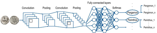
This paper [1] presents an innovative approach to address the prevalent challenge of unbalanced datasets in coin type recognition, shifting the focus from coin class type recognition to coin mint recognition. Despite this shift, the issue of unbalanced data persists. To mitigate this, the authors introduce a method to split larger classes into smaller ones, integrating them into an 'additional class layer'. Three distinct machine learning (ML) methodologies were employed to identify new possible classes, with one approach utilising unsupervised clustering alongside manual intervention, while the others leverage object detection, and Natural Language Processing (NLP) techniques. However, despite these efforts, overfitting remained a persistent issue, prompting the authors to explore alternative methods such as dataset improvement and Generative Adversarial Networks (GANs). The paper contributes significantly to the intersection of ML techniques and archaeology, particularly in addressing overfitting challenges. Furthermore, the authors' candid acknowledgment of the limitations of their approaches serves as a valuable resource for researchers encountering similar obstacles. This study stems from the D4N4 project, aimed at developing a machine learning-based coin recognition model for the extensive "Corpus Nummorum" dataset, comprising over 19,600 coin types and 49,000 coins from various ancient landscapes. Despite encountering challenges with overfitting due to the dataset's imbalance, the authors' exploration of multiple methodologies and transparent documentation of their limitations enriches the academic discourse and provides a foundation for future research in this field. Reference [1] Gampe, S. and Tolle, K. (2024). Creating an Additional Class Layer with Machine Learning to counter Overfitting in an Unbalanced Ancient Coin Dataset. Zenodo, 8298077, ver. 4 peer-reviewed and recommended by Peer Community in Archaeology. https://doi.org/10.5281/zenodo.8298077 | Creating an Additional Class Layer with Machine Learning to counter Overfitting in an Unbalanced Ancient Coin Dataset | Sebastian Gampe, Karsten Tolle | <p>We have implemented an approach based on Convolutional Neural Networks (CNN) for mint recognition for our Corpus Nummorum (CN) coin dataset as an alternative to coin type recognition, since we had too few instances for most of the types (classe... | | Computational archaeology | Alex Brandsen | 2023-08-29 16:26:41 | ||
14 May 2024
Supporting the analysis of a large coin hoard with AI-based methodsA demonstration of the use and finetuning of existing machine learning tools for analysing large complexes of coinsRecommended by Alex Brandsen based on reviews by 2 anonymous reviewers
The paper outlines the ClaReNet project's exploration of computer-based methods for classifying Celtic coin series, specifically focusing on a hoard from Jersey [1]. They collaborated with Jersey Heritage and numismatists, utilising a large dataset of coin images. The process involves stages such as pre-sorting, size-based sorting, class/type identification, and die studies. They employed IT methods, including object detection and unsupervised learning, followed by supervised learning for data refinement. Collaboration with numismatic experts ensured data quality. The study highlighted challenges in classifying coins, suggesting techniques like image matching alongside convolutional neural networks (CNNs). The results demonstrate the efficacy of semi-automatic processes in coin classification, emphasising the importance of human-computer collaboration for successful outcomes. Overall, this is a good paper, showing how we as archaeologists and numismatics can use existing tools and finetune them for our purposes; without the need for huge domain specific datasets. This research and related papers show how we can more effectively deal with the increasingly bigger data we deal with, saving time on the monotonous and labour intensive tasks, leaving us more time to deal with the big picture. An important strength of the work is the provided public software repository and the dataset. The paper is well written, and a number of images illustrate the methodology as well as the objects used. Reference [1] Deligio, C., Tolle, K., and Wigg-Wolf, D. (2024). Supporting the analysis of a large coin hoard with AI-based methods. Zenodo, 8301464, ver. 4 peer-reviewed and recommended by Peer Community in Archaeology. https://doi.org/10.5281/zenodo.8301464
| Supporting the analysis of a large coin hoard with AI-based methods | Chrisowalandis Deligio, Karsten Tolle, David Wigg-Wolf | <p>In the project "Classifications and Representations for Networks: From types and characteristics to linked open data for Celtic coinages" (ClaReNet) we had access to image data for one of the largest Celtic coin hoards ever found: Le Câtillon I... | | Computational archaeology | Alex Brandsen | 2023-08-30 15:31:16 | ||
02 Apr 2024
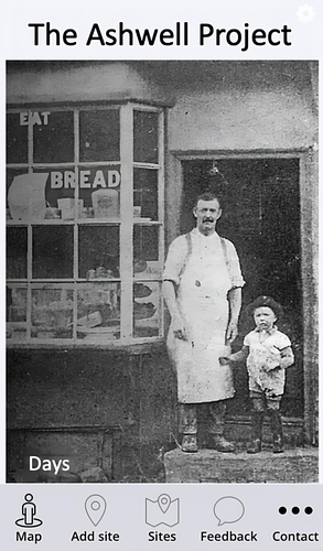
The Ashwell Project: Creating an Online Geospatial CommunityA nice project looking at under-represented demographicRecommended by Alexis Pantos based on reviews by Catriona Cooper and Steinar Kristensen
The paper by A. Lien-Talks [1] presents a small project looking at the use of crowd sourced data collection and particpatory GIS. In particular it looks at the potential of these tools in response to socially disruptive and isolating events such as the COVID-19 pandemic as well as the potential role of digitially mediated heritage initiatives in tackling some of the challenges of changing demographics and life styles. The types of technologies employed are relatively mature, the project identifies potential for such approaches to be used within the local-history/local community settings, though is also a reminer that depsite the much broader adoption of technology within all areas of society than even a few years ago many barriers still remain. While the the sample size and data collected in the project is relatively modest, the focus on empathy toward the intended audiences from the design process, as well as some of the qualitative feedback reported serve as a reminder that participatory, or crowd-sourced data collection initiatives in heritage can, and perhaps should place potential social benefit before data-acquisition of objectives. The project also presents a demographic that is not often represented within the literature and the publication and as such the publication of the article represents a meaningful contribution to ongoing discussions of the role heritage and digitally mediated community archaeology can play a role in developing our societies. References [1] Lien-Talks, A. (2024). The Ashwell Project: Creating an Online Geospatial Community. Zenodo, 8307882, ver. 4 peer-reviewed and recommended by Peer Community in Archaeology. https://doi.org/10.5281/zenodo.8307882 | The Ashwell Project: Creating an Online Geospatial Community | Alphaeus Lien-Talks | <p>Background:<br>As the world becomes increasingly digital, so too must the way in which archaeologists engage with the public. This was particularly important during the COVID-19 pandemic, and many outreach and engagement efforts began to move o... | | Computational archaeology | Alexis Pantos | 2023-09-01 11:25:54 | ||
22 Apr 2024
Cultural Significance Assessment of Archaeological Sites for Heritage Management: From Text of Spatial Networks of MeaningsHow Semantic Technologies and Spatial Networks Can Enhance Archaeological Resource ManagementRecommended by James Stuart Taylor based on reviews by Dominik Lukas and 1 anonymous reviewer
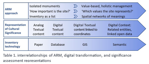
After a thorough review and consideration of the revised manuscript titled "Cultural Significance Assessment of Archaeological Sites for Heritage Management: From Text to Spatial Networks of Meanings" by Yael Alef and Yuval Shafriri [1], I am recommending the paper for publication. The authors have made significant strides in addressing the feedback from the initial review process, notably enhancing the manuscript's clarity, methodological detail, and overall contribution to the field of Archaeological Resource Management (ARM). On balance I think the paper competently navigates the shift from a traditional significance-focused assessment of isolated archaeological sites to a more holistic and interconnected approach, leveraging graph data models and spatial networks. This transition represents an advancement in the field, offering deeper insights into the sociocultural dynamics of archaeological sites. The case study of ancient synagogues in northern Israel, particularly the Huqoq Synagogue, serves as a compelling illustration of the potential of semantic technologies to enrich our understanding of cultural heritage. Significantly, the authors have responded to the call for a clearer methodological framework by providing a more detailed exposition of their use of knowledge graph visualization and semantic technologies. This response not only strengthens the paper's scientific rigor but also enhances its accessibility and applicability to a broader audience within the conservation and heritage management community. However, I do think it remains important to acknowledge areas where further work could enrich the paper's contribution. While the manuscript makes notable advancements in the technical and methodological domains, the exploration of the ethical and political implications of semantic technologies in ARM remains less developed. Recognizing the complex interplay of ethical and political considerations in archaeological assessments is crucial for the responsible advancement of the field. Thus, I suggest that future work could productively focus on these dimensions, offering a more comprehensive view of the implications of integrating semantic technologies into heritage management practices. I don't think that this omission is a reason to withold the paper for publication or seek further review. In fact I think it stands alone a paper quite well. Perhaps the authors might consider this as a complementary line of inquiry in their future work in the field. In conclusion then, I believe the revised manuscript represents a valuable addition to the literature, pushing boundaries of how we assess, understand, and manage archaeological resources. Its focus on semantic technologies and the creation of spatial networks of meanings marks a significant step forward in the field. I believe its publication will stimulate further research and discussion, particularly in the realms of ethical and political considerations, which remain ripe for exploration. Therefore, I'm happy to endorse the publication of this manuscript. Reference [1] Alef, Y and Shafriri, Y. (2024). Cultural Significance Assessment of Archaeological Sites for Heritage Management: From Text of Spatial Networks of Meanings. Zenodo, 8309992, ver. 5 peer-reviewed and recommended by Peer Community in Archaeology. https://doi.org/10.5281/zenodo.8309992 | Cultural Significance Assessment of Archaeological Sites for Heritage Management: From Text of Spatial Networks of Meanings | Yael Alef, Yuval Shafriri | <p>This study examines the shift towards a values-based approach for Archaeological Resource Management (ARM), emphasizing the integration of Context-Based Significance Assessment (CBSA) with semantic technologies into digital ARM inventories. We ... | | Computational archaeology, Conservation/Museum studies, Spatial analysis | James Stuart Taylor | 2023-09-01 22:24:15 | ||
08 Jan 2024
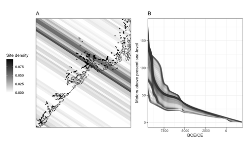
Comparing summed probability distributions of shoreline and radiocarbon dates from the Mesolithic Skagerrak coast of NorwayTaking the Reverend Bayes to the seaside: Improving Norwegian Mesolithic shoreline dating with advanced statistical approachesRecommended by Felix Riede based on reviews by 2 anonymous reviewersThe paper entitled “Comparing summed probability distributions of shoreline and radiocarbon dates from the Mesolithic Skagerrak coast of Norway” by Isak Roalkvam and Steinar Solheim (2024) sheds new light on the degree to which shoreline dating may be used as a reliable chronological and palaeodemographic proxy in the Mesolthic of southern Norway. Based on geologically motivated investigations of eustatic and isostatic sea-level changes, shoreline dating has long been used as a method to date archaeological sites in Scandinavia, not least in Norway (e.g., Bjerck 2008; Astrup 2018). Establishing reliable sea-level curves requires much effort and variations across regions may be substantial. While this topic has seen a great deal of attention in Norway specifically, many purely geological questions remain. In addition, dating archaeological sites by linking their elevation to previously established seal-level curves relies strongly on the foundational assumption that such sites were in fact shore-bound. Given the strong contrast between terrestrial and marine productivity in high-latitude regions such as Norway, this assumption per se is not unreasonable. It is very likely that the sea has played a decisive role in the lives of Stone Age peoples throughout (Persson et al. 2017), just as it has in later periods here. However, many confounding factors relating to both taphonomy and human behaviour are also likely to have loosened the shore/site relationship. Systematic variations driven by cultural norms about settlement location, mobility, as well as factors such as shelter construction, fuel use and a range of other possible factors could variously have impacted the validity or at least the precision of shoreline dating. By developing a new methodology for handling and assessing a large number of shoreline dated sites, Roalkvam and Solheim use state-of-the-art Bayesian statistical methods to compare shoreline and radiocarbon dates as proxies for population activity. The probabilistic treatment of shoreline dates in this way is novel, and the divergences between the two data sets are interpreted by the authors in light of specific behavioural, cultural, and demographic changes. Many of the peaks and troughs observed in these time-series may be interpreted in light of long-observed cultural transitions while others may relate to population dynamics now also visible in palaeogenomic analyses (Günther et al. 2018; Manninen et al. 2021). Overall, this paper makes an innovative and fresh contribution to the use of shoreline dating in Norwegian archaeology, specifically by articulating it with recent developments in Open Science and data-driven approaches to archaeological questions (Marwick et al. 2017). References Astrup, P. M. 2018. Sea-Level Change in Mesolithic Southern Scandinavia : Long- and Short-Term Effects on Society and the Environment. Aarhus: Aarhus University Press. Bjerck, H. B. 2008. Norwegian Mesolithic Trends: A Review. In Mesolithic Europe, edited by Geoff Bailey and Penny Spikins, 60–106. Cambridge: Cambridge University Press. Günther, T., Malmström, H., Svensson, E. M., Omrak, A., Sánchez-Quinto, F., Kılınç, G. M., Krzewińska, M. et al. 2018. Population Genomics of Mesolithic Scandinavia: Investigating Early Postglacial Migration Routes and High-Latitude Adaptation. PLOS Biology 16 (1): e2003703. https://doi.org/10.1371/journal.pbio.2003703 Manninen, M. A., Damlien, H., Kleppe, J. I., Knutsson, K., Murashkin, A., Niemi, A. R., Rosenvinge, C. S. and Persson, P. 2021. First Encounters in the North: Cultural Diversity and Gene Flow in Early Mesolithic Scandinavia. Antiquity 95 (380): 310–28. https://doi.org/10.15184/aqy.2020.252 Marwick, B., d’Alpoim Guedes, J. A., Barton, C. M., Bates, L. A., Baxter, M., Bevan, A., Bollwerk, E. A. et al. 2017. Open Science in Archaeology. The SAA Archaeological Record 17 (4): 8–14. https://doi.org/10.31235/osf.io/72n8g Persson, P., Riede, F., Skar, B., Breivik, H. M. and Jonsson, L. 2017. The Ecology of Early Settlement in Northern Europe: Conditions for Subsistence and Survival. Sheffield: Equinox. Roalkvam, I. and Solheim, S. (2024). Comparing summed probability distributions of shoreline and radiocarbon dates from the Mesolithic Skagerrak coast of Norway, SocArXiv, 2f8ph, ver. 5 peer-reviewed and recommended by Peer Community in Archaeology. https://doi.org/10.31235/osf.io/2f8ph | Comparing summed probability distributions of shoreline and radiocarbon dates from the Mesolithic Skagerrak coast of Norway | Isak Roalkvam, Steinar Solheim | <p>By developing a new methodology for handling and assessing a large number of shoreline dated sites, this paper compares the summed probability distribution of radiocarbon dates and shoreline dates along the Skagerrak coast of south-eastern Norw... | | Computational archaeology, Dating, Europe, Mesolithic, Paleoenvironment | Felix Riede | 2023-09-26 16:43:29 |


