Latest recommendations

| Id | Title * ▲ | Authors * | Abstract * | Picture * | Thematic fields * | Recommender | Reviewers | Submission date | |
|---|---|---|---|---|---|---|---|---|---|
02 May 2023
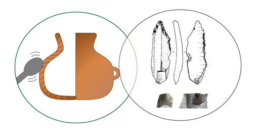
Transmission of lithic and ceramic technical know-how in the Early Neolithic of central-western Europe: Shedding Light on the Social Mechanisms underlying Cultural TransitionA Thought Provoking Consideration of Craft in the NeolithicRecommended by Clare Burke based on reviews by Bogdana Milić and 1 anonymous reviewerThe pioneering work of Leroi-Gourhan introduced archaeologists to the concept of the chaîne opératoire[1], whereby, like his supervisor Mauss[2], Leroi-Gourhan proposed direct links between bodily actions and aspects of cultural identity. The chaîne opératoire offers a powerful conceptual tool with which to reconstruct and describe the technological practices undertaken by craftspeople, linking material objects to the cultural context in which crafts are learnt. Although initially applied to lithics, the concept today is well known in ceramic studies, as well as, other material crafts, in order to identify aspects of tradition and identity through ideas linked to technological style[3,4] and communities of practice[5]. Utilizing this approach, Denis et al.[6] use the chaîne opératoire to look at both lithics and ceramics together from a diachronic viewpoint, to examine technical systems present over the transition between Linearbandkeramic (LBK) and post LBK Blicquy/Villeneuve-Saint German (BQY/VSG) timeframes. This much needed comparative and diachronic perspective, focuses on material from the sites of Vaux-et-Borset and Verlaine in Belgium, and has enabled the authors to consider the impact of changing social dynamics on these two crafts simultaneously. The authors examine the ceramic and lithic assemblages from a macroscopic and morphological perspective in order to identify techniques of production. The data gathered testifies to the dominance of one production technique for each craft within the LBK. There is particularly striking homogeneity noted for the lithics that suggests the transmission of a single tradition over the Hesbaye area, whilst the ceramics display greater regional diversity. The picture alters somewhat for the BQY/VSG material where it seems there is an increase in the diversity of production techniques, with both the introduction of new techniques, as well as a degree of hybridization of earlier techniques to form new BQY/VSG chaînes opératoires that have LBK roots. The BQY/VSG diversity noted for the lithics is especially interesting, with the introduction of techniques that attest to increased expertise which the authors attest to the migration of an external group. The results of this work have allowed Denis et al. to discuss multiple influences on the technical systems they identify. Rather than trying to fit the data within a single model, the authors demonstrate the need for nuance, considering the social changes associated with Neolithic migration and interactions, as multifaced and dynamic. As such, they are able to show not only the influence of contact with other groups, but that the apparent migration of external groups does not simply lead to the replacement of the crafting heritage already established at the sites they have examined. In concluding the authors acknowledge, that as scholars push the existing state of knowledge (in this respect analysis of raw materials would make an especially important contribution), the picture presented in the paper may alter. Future work will hopefully fill in current gaps, particularly in terms of how far the trends identified extend, and the extent to which the lithic and ceramic pictures diversify on a broader geographical scale. It is certain that based on such results, future work should adopt the comparative approach presented by the authors, who have demonstrated its explanatory potential for understanding the technical and cultural groups we all study. [2] Mauss, M. 2009 [1934]. Techniques, Technology and Civilisation. Edited and introduced by N. Schlanger. New York/Oxford: Durkheim Press/Berghahn Books. [3] Lechtman, H. 1977. Style in Technology: some early thoughts. In H. Lechtman and R.S. Merrill (eds.) Material Culture: styles, organization and dynamics of technology. Proceedings of the American Ethnological Society 1975, St. Paul, 3-20. [4] Gosselain, O. 1992. Technology and Style: Potters and Pottery Among Bafia of Cameroon. Man 27(3) 559- 586. htpps://doi.org/10.2307/2803929. [5] Wenger, E. 1998. Communities of practice: Learning, meaning, and identity. Cambridge: Cambridge University Press. [6] Denis, S., Gomart, L., Burnez-Lanotte, L. and Allard, P. (2023). Transmission of lithic and ceramic technical know-how in the Early Neolithic of central-western Europe: Shedding Light on the Social Mechanisms underlying Cultural Transition. OSF Preprints, gqnht, ver. 5 peer-reviewed and recommended by Peer Community in Archaeology. https://doi.org/10.31219/osf.io/gqnht
| Transmission of lithic and ceramic technical know-how in the Early Neolithic of central-western Europe: Shedding Light on the Social Mechanisms underlying Cultural Transition | Solène Denis, Louise Gomart, Laurence Burnez-Lanotte, Pierre Allard | <p>Research on the European Neolithisation agrees that a process of colonisation throughout the sixth millennium BC underlies the spread of agricultural ways of life on the continent. From central to central-western Europe, this colonisation path ... | | Ceramics, Europe, Lithic technology, Neolithic | Clare Burke | 2022-11-18 12:03:55 | ||
20 Feb 2024
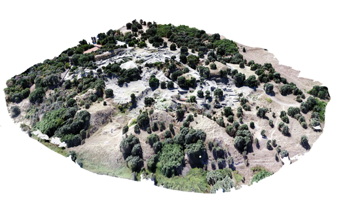
Understanding Archaeological Site Topography: 3D Archaeology of ArchaeologyRewriting Archaeological Narratives: Archaeology of Archaeology through 3D Site Topography RecordingRecommended by Devi Taelman based on reviews by Geert Verhoeven, Jesús García-Sánchez and Catherine Scott based on reviews by Geert Verhoeven, Jesús García-Sánchez and Catherine Scott
Even though applications of 3D recording have existed in archaeology for a long time, it is only since the early 2000s that this field of research has become mainstream thanks to technological advances, and the availability of low-cost sensors and image-based modelling software. This has led to significant changes in the way archaeological sites are documented. This paper entitled "Understanding Archaeological Site Topography: 3D Archaeology of Archaeology" by Jitte Waagen & Gert Jan van Wijngaarden (2024) presents an overview of the current developments in the application possibilities of 3D site topography recording in archaeology. The paper is the result of the round table discussion "Understanding Archaeological Site Topography: 3D Archaeology of Archaeology" at the CAA conference on 5 April 2023 in Amsterdam, with contributions from Radu Brunchi, Nicola Lercari, Joep Orbons, Davide Tanasi, Alicia Walsh, Pawel Wolf and Teagan Zoldoske. The paper starts with a discussion of the Amsterdam Troy Project (ATP). In the frame of the ATP, the rich history of archaeological activity (over 150 years of fieldwork) at Troy is being studied to explore how previous archaeological research has helped to shape the current topography of the site and how these earlier research activities, embedded in their contemporary theoretical frameworks, have determined our understanding of the site (see Murray and M. Spriggs 2017, Carver 2011 for the influence of theory on archaeological fieldwork and archaeology as a discipline), the so-called 'Archaeology of Archaeology' approach. In addition to studying previous research records and re-excavating old excavation trenches, a central element of the project is the 3D recording of the past and present topography of the site in order to reconstruct the archaeological research activities at the site and their impact on the archaeological landscape. The paper focuses on current trends in 3D recording of archaeological site topography and discusses three main areas where 3D recording of archaeological site topography can contribute to the "Archaeology of Archaeology" approach: (1) monitoring the topography of sites for preservation, conservation, research and dissemination purposes; (2) reconstructing, reevaluating and reinterpreting past archaeological research efforts; and (3) archiving in a 4D (GIS) environment. This is done using the example of the Amsterdam Troy project and comparing it with other projects using similar methods and approaches. Using these case studies, the authors effectively discuss the impact of these technologies on the understanding of the topography of archaeological sites and how 3D recording can enhance archaeological research methodologies and interpretations, for example, by not using such 3D approaches as a stand-alone product but integrating them with available information from previous research activities. They also recognise the limitations and challenges involved, such as the need for customised data acquisition strategies and the lack of ready-made software solutions for developing comprehensive data management strategies. One topic that could have been covered in more detail is how 3D site topography recording (and 3D recording in general) is affected by current theoretical developments in archaeology. Like any other archaeological fieldwork or data collection approach, it is a child of its time. Decisions such as what to record, how to record, what to store, how to store, what to visualise, and how to visualise influence our understanding of archaeological sites (Ward 2022). This minor critical reflection aside, the paper makes a timely and significant contribution to archaeology by addressing current trends and the limitations of the increasingly widespread use of 3D site topography recording technologies. References Carver, G. (2011). Reflections on the archaeology of archaeological excavation, Archaeological Dialogues 18(1), pp. 18–26. https://doi.org/10.1017/S1380203811000067 Murray, T. and Spriggs, M. (2017). The historiography of archaeology: exploring theory, contingency and rationality, World Archaeology 49(2), pp. 151–157. https://doi.org/10.1080/00438243.2017.1334583 Ward, C. (2022). Excavating the Archive / Archiving the Excavation: Archival Processes and Contexts in Archaeology, Advances in Archaeological Practice 10(2), pp. 160–176. https://doi.org/10.1017/aap.2022.1 Waagen, J. and van Wijngaarden, G.J. (2024). Understanding Archaeological Site Topography: 3D Archaeology of Archaeology, Zenodo, 10061343, ver. 3 peer-reviewed and recommonded by Peer Community in Archaeology. https://doi.org/10.5281/zenodo.10061343 | Understanding Archaeological Site Topography: 3D Archaeology of Archaeology | Waagen, Jitte & Wijngaarden, Gert Jan van | <p>The current ubiquitous use of 3D recording technologies in archaeological fieldwork, for a large part due to the application of budget-friendly (drone) sensors and the availability of many low-cost image-based 3D modelling software packages, ha... | | Computational archaeology, Remote sensing | Devi Taelman | 2023-10-17 23:03:47 | ||
29 Jan 2024
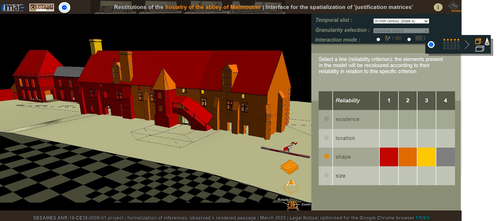
Visual encoding of a 3D virtual reconstruction's scientific justification: feedback from a proof-of-concept research3D Models, Knowledge and Visualization: a prototype for 3D virtual models according to plausible criteriaRecommended by Daniel Carvalho based on reviews by Robert Bischoff and Louise TharandtThe construction of 3D realities is deeply embedded in archaeological practices. From sites to artifacts, archaeology has dedicated itself to creating digital copies for the most varied purposes. The paper “Visual encoding of a 3D virtual reconstruction's 3 scientific justification: feedback from a proof-of-concept research” (Jean-Yves et al 2024) represents an advance, in the sense that it does not just deal with a three-dimensional theory for archaeological practice, but rather offers proposals regarding the epistemic component, how it is possible to represent knowledge through the workflow of 3D virtual reconstructions themselves. The authors aim to unite three main axes - knowledge modeling, visual encoding and 3D content reuse - (Jean-Yves et al 2024: 2), which, for all intents and purposes, form the basis of this article. With regard to the first aspect, this work questions how it is possible to transmit the knowledge we want to a 3D model and how we can optimize this epistemic component. A methodology based on plausibility criteria is offered, which, for the archaeological field, offers relevant space for reflection. Given our inability to fully understand the object or site that is the subject of the 3D representation, whether in space or time, building a method based on probabilistic categories is probably one of the most realistic approaches to the realities of the past. Thus, establishing a plausibility criterion allows the user to question the knowledge that is transmitted through the representation, and can corroborate or refute it in future situations. This is because the role of reusing these models is of great interest to the authors, a perfectly justifiable sentiment, as it encourages a critical view of scientific practices. Visual encoding is, in terms of its conjunction with knowledge practices, a key element. The notion of simplicity under Maeda's (2006) design principles not only represents a way of thinking that favors operability, but also a user-friendly design in the prototype that the authors have created. This is also visible when it comes to the reuse of parts of the models, in a chronological logic: adapting the models based on architectural elements that can be removed or molded is a testament to intelligent design, whereby instead of redoing models in their entirety, they are partially used for other purposes. All these factors come together in the final prototype, a web application that combines relational databases (RDBMS) with a data mapper (MassiveJS), using the PHP programming language. The example used is the Marmoutier Abbey hostelry, a centuries-old building which, according to the sources presented, has evolved architecturally over several centuries ((Jean-Yves et al 2024: 8). These states of the building are represented visually through architectural elements based on their existence, location, shape and size, always in terms of what is presented as being plausible. This allows not only the creation of a matrix in which various categories are related to various architectural elements, but also a visual aid, through a chromatic spectrum, of the plausibility that the authors are aiming for. In short, this is an article that seeks to rethink the degree of knowledge we can obtain through 3D visualizations and that does not take models as static, but rather realities that must be explored, recycled and reinterpreted in the light of different data, users and future research. For this reason, it is a work of great relevance to theoretical advances in 3D modeling adapted to archaeology.
References Blaise, J.-Y., Dudek, I., Bergerot, L. and Gaël, S. (2024). Visual encoding of a 3D virtual reconstruction's scientific justification: feedback from a proof-of-concept research, Zenodo, 7983163, ver. 3 peer-reviewed and recommended by Peer Community in Archaeology. https://doi.org/10.5281/zenodo.10496540 John Maeda. (2006). The Laws of Simplicity. MIT Press, Cambridge, MA, USA. | Visual encoding of a 3D virtual reconstruction's scientific justification: feedback from a proof-of-concept research | J.Y Blaise, I.Dudek, L.Bergerot, G.Simon | <p> 3D virtual reconstructions have become over the last decades a classical mean to communicate about analysts’ visions concerning past stages of development of an edifice or a site. However, they still today remain quite often a one-s... | | Computational archaeology, Spatial analysis | Daniel Carvalho | 2023-05-30 00:43:03 | ||
26 Mar 2024
What is a form? On the classification of archaeological pottery.Abstract and Concrete – Querying the Metaphysics and Geometry of Pottery ClassificationRecommended by Shumon Tobias Hussain, Felix Riede and Sébastien Plutniak based on reviews by 2 anonymous reviewers
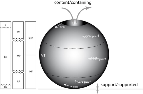
“What is a form? On the classification of archaeological pottery” by P. Boissinot (1) is a timely contribution to broader theoretical reflections on classification and ordering practices in archaeology, including type-construction and justification. Boissinot rightly reminds us that engagement with the type concept always touches upon the uneasy relationship between the abstract and the concrete, alternatively cast as the ongoing struggle in knowledge production between idealization and particularization. Types are always abstract and as such both ‘more’ and ‘less’ than the concrete objects they refer to. They are ‘more’ because they establish a higher-order identity of variously heterogeneous, concrete objects and they are ‘less’ because they necessarily reduce the richness of the concrete and often erase it altogether. The confusion that types evoke in archaeology and elsewhere has therefore a lot to do with the fact that types are simply not spatiotemporally distinct particulars. As abstract entities, types so almost automatically re-introduce the question of universalism but they do not decide this question, and Boissinot also tentatively rejects such ambitions. In fact, with Boissinot (1) it may be said that universality is often precisely confused with idealization, which is indispensable to all archaeological ordering practices. Idealization, increasingly recognized as an important epistemic operation in science (2, 3), paradoxically revolves around the deliberate misrepresentation of the empirical systems being studied, with models being the paradigm cases (4). Models can go so far as to assume something strictly false about the phenomena under consideration in order to advance their epistemic goals. In the words of Angela Potochnik (5), ‘the role of idealization in securing understanding distances understanding from truth but […] this understanding nonetheless gives rise to scientific knowledge’. The affinity especially to models may in part explain why types are so controversial and are often outright rejected as ‘real’ or ‘useful’ by those who only recognize the existence of concrete particulars (nominalism). As confederates of the abstract, types thus join the ranks of mathematics and geometry, which the author identifies as prototypical abstract systems. Definitions are also abstract. According to Boissinot (1), they delineate a ‘position of limits’, and the precision and rigorousness they bring comes at the cost of subjectivity. This unites definitions and types, as both can be precise and clear-cut but they can never be strictly singular or without alternative – in order to do so, they must rely on yet another higher-order system of external standards, and so ad infinitum. Boissinot (1) advocates a mathematical and thus by definition abstract approach to archaeological type-thinking in the realm of pottery, as the abstractness of this approach affords relatively rigorous description based on the rules of geometry. Importantly, this choice is not a mysterious a priori rooted in questionable ideas about the supposed superiority of such an approach but rather is the consequence of a careful theoretical exploration of the particularities (domain-specificities) of pottery as a category of human practice and materiality. The abstract thus meets the concrete again: objects of pottery, in sharp contrast to stone artefacts for example, are the product of additive processes. These processes, moreover, depend on the ‘fusion’ of plastic materials and the subsequent fixation of the resulting configuration through firing (processes which, strictly speaking, remove material, such as stretching, appear to be secondary vis-à-vis global shape properties). Because of this overriding ‘fusion’ of pottery, the identification of parts, functional or otherwise, is always problematic and indeterminate to some extent. As products of fusion, parts and wholes represent an integrated unity, and this distinguishes pottery from other technologies, especially machines. The consequence is that the presence or absence of parts and their measurements may not be a privileged locus of type-construction as they are in some biological contexts for example. The identity of pottery objects is then generally bound to their fusion. As a ‘plastic montage’ rather than an assembly of parts, individual parts cannot simply be replaced without threatening the identity of the whole. Although pottery can and must sometimes be repaired, this renders its objects broadly morpho-static (‘restricted plasticity’) rather than morpho-dynamic, which is a condition proper to other material objects such as lithic (use and reworking) and metal artefacts (deformation) but plays out in different ways there. This has a number of important implications, namely that general shape and form properties may be expected to hold much more relevant information than in technological contexts characterized by basal modularity or morpho-dynamics. It is no coincidence that ‘fusion’ is also emphasized by Stephen C. Pepper (6) as a key category of what he calls contextualism. Fusion for Pepper pays dividends to the interpenetration of different parts and relations, and points to a quality of wholes which cannot be reduced any further and integrates the details into a ‘more’. Pepper maintains that ‘fusion, in other words, is an agency of simplification and organization’ – it is the ‘ultimate cosmic determinator of a unit’ (p. 243-244, emphasis added). This provides metaphysical reasons to look at pottery from a whole-centric perspective and to foreground the agency of its materiality. This is precisely what Boissinot (1) does when he, inspired by the great techno-anthropologist François Sigaut (7), gestures towards the fact that elementarily a pot is ‘useful for containing’. He thereby draws attention not to the function of pottery objects but to what pottery as material objects do by means of their material agency: they disclose a purposive tension between content and container, the carrier and carried as well as inclusion and exclusion, which can also be understood as material ‘forces’ exerted upon whatever is to be contained. This, and not an emic reading of past pottery use, leads to basic qualitative distinctions between open and closed vessels following Anna O. Shepard’s (8) three basic pottery categories: unrestricted, restricted, and necked openings. These distinctions are not merely intuitive but attest to the object-specificity of pottery as fused matter. This fused dimension of pottery also leads to a recognition that shapes have geometric properties that emerge from the forced fusion of the plastic material worked, and Boissinot (1) suggests that curvature is the most prominent of such features, which can therefore be used to describe ‘pure’ pottery forms and compare abstract within-pottery differences. A careful mathematical theorization of curvature in the context of pottery technology, following George D. Birkhoff (9), in this way allows to formally distinguish four types of ‘geometric curves’ whose configuration may serve as a basis for archaeological object grouping. The idealization involved in this proposal is not accidental but deliberately instrumental – it reminds us that type-thinking in archaeology cannot escape the abstract. It is notable here that the author does not suggest to simply subject total pottery form to some sort of geometric-morphometric analysis but develops a proposal that foregrounds a limited range of whole-based geometric properties (in contrast to part-based) anchored in general considerations as to the material specificity of pottery as quasi-species of objects. As Boissinot (1) notes himself, this amounts to a ‘naturalization’ of archaeological artefacts and offers somewhat of an alternative (a third way) to the old discussion between disinterested form analysis and functional (and thus often theory-dependent) artefact groupings. He thereby effectively rejects both of these classic positions because the first ignores the particularities of pottery and the real function of artefacts is in most cases archaeologically inaccessible. In this way, some clear distance is established to both ethnoarchaeology and thing studies as a project. Attending to the ‘discipline of things’ proposal by Bjørnar Olsen and others (10, 11), and by drawing on his earlier work (12), Boissinot interestingly notes that archaeology – never dealing with ‘complete societies’ – could only be ‘deficient’. This has mainly to do with the underdetermination of object function by the archaeological record (and the confusion between function and functionality) as outlined by the author. It seems crucial in this context that Boissinot does not simply query ‘What is a thing?’ as other thing-theorists have previously done, but emphatically turns this question into ‘In what way is it not the same as something else?’. He here of course comes close to Olsen’s In Defense of Things insofar as the ‘mode of being’ or the ‘ontology’ of things is centred. What appears different, however, is the emphasis on plurality and within-thing heterogeneity on the level of abstract wholes. With Boissinot, we always have to speak of ontologies and modes of being and those are linked to different kinds of things and their material specificities. Theorizing and idealizing these specificities are considered central tasks and goals of archaeological classification and typology. As such, this position provides an interesting alternative to computational big-data (the-more-the-better) approaches to form and functionally grounded type-thinking, yet it clearly takes side in the debate between empirical and theoretical type-construction as essential object-specific properties in the sense of Boissinot (1) cannot be deduced in a purely data-driven fashion. Boissinot’s proposal to re-think archaeological types from the perspective of different species of archaeological objects and their abstract material specificities is thought-provoking and we cannot stop wondering what fruits such interrogations would bear in relation to other kinds of objects such as lithics, metal artefacts, glass, and so forth. In addition, such meta-groupings are inherently problematic themselves, and they thus re-introduce old challenges as to how to separate the relevant super-wholes, technological genesis being an often-invoked candidate discriminator. The latter may suggest that we cannot but ultimately circle back on the human context of archaeological objects, even if we, for both theoretical and epistemological reasons, wish to embark on strictly object-oriented archaeologies in order to emancipate ourselves from the ‘contamination’ of language and in-built assumptions.
Bibliography 1. Boissinot, P. (2024). What is a form? On the classification of archaeological pottery, Zenodo, 7429330, ver. 4 peer-reviewed and recommended by Peer Community in Archaeology. https://doi.org/10.5281/zenodo.10718433 2. Fletcher, S.C., Palacios, P., Ruetsche, L., Shech, E. (2019). Infinite idealizations in science: an introduction. Synthese 196, 1657–1669. https://doi.org/10.1007/s11229-018-02069-6 3. Potochnik, A. (2017). Idealization and the aims of science (University of Chicago Press). https://doi.org/10.7208/chicago/9780226507194.001.0001 4. J. Winkelmann, J. (2023). On Idealizations and Models in Science Education. Sci & Educ 32, 277–295. https://doi.org/10.1007/s11191-021-00291-2 5. Potochnik, A. (2020). Idealization and Many Aims. Philosophy of Science 87, 933–943. https://doi.org/10.1086/710622 6. Pepper S. C. (1972). World hypotheses: a study in evidence, 7. print (University of California Press). 7. Sigaut, F. (1991). “Un couteau ne sert pas à couper, mais en coupant. Structure, fonctionnement et fonction dans l’analyse des objets” in 25 Ans d’études Technologiques En Préhistoire. Bilan et Perspectives (Association pour la promotion et la diffusion des connaissances archéologiques), pp. 21–34. 8. Shepard, A. O. (1956). Ceramics for the Archeologist (Carnegie Institution of Washington n° 609). 9. Birkhoff G. D. (1933). Aesthetic Measure (Harvard University Press). 10. Olsen, B. (2010). In defense of things: archaeology and the ontology of objects (AltaMira Press). https://doi.org/10.1093/jdh/ept014 11. Olsen, B., Shanks, M., Webmoor, T., Witmore, C. (2012). Archaeology: the discipline of things (University of California Press). https://doi.org/10.1525/9780520954007 12. Boissinot, P. (2011). “Comment sommes-nous déficients ?” in L’archéologie Comme Discipline ? (Le Seuil), pp. 265–308. | What is a form? On the classification of archaeological pottery. | Philippe Boissinot | <p>The main question we want to ask here concerns the application of philosophical considerations on identity about artifacts of a particular kind (pottery). The purpose is the recognition of types and their classification, which are two of the ma... | | Ceramics, Theoretical archaeology | Shumon Tobias Hussain | 2022-12-13 15:04:45 | ||
16 May 2022
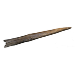
Wood technology: a Glossary and Code for analysis of archaeological wood from stone tool culturesOpen glossary for wood technologiesRecommended by Ruth Blasco based on reviews by Paloma Vidal-Matutano, Oriol López-Bultó, Eva Francesca Martellotta and Laura Caruso Fermé
Wood is a widely available and versatile material, so it is not surprising that it has been a key resource throughout human history. However, it is more vulnerable to decomposition than other materials, and its direct use is only rarely recorded in prehistoric sites. Despite this, there are exceptions (e.g., [1-5] [6] and references therein), and indirect evidence of its use has been attested through use-wear analyses, residue analyses (e.g., [7]) and imprints on the ground (e.g., [8]). One interesting finding of note is that the technology required to make, for example, wooden spears was quite complex [9], leading some authors to propose that this type of tool production represented a cognitive leap for Pleistocene hominids [10]. Other researchers, however, have proposed that the production process for wooden tools could have been much easier than is currently thought [11]. Be that as it may, in recent years researchers have begun to approach wood remains systematically, developing analyses of natural and anthropogenic damage, often with the help of experimental reference samples. In this work, the authors elaborate a comprehensive glossary as a first step towards the understanding of the use of wood for technological purposes in different times and places, as there is still a general gap in the established nomenclature. Thus, this glossary is a synthesis and standardisation of analytical terms for early wood technologies that includes clear definitions and descriptions of traces from stone tool-using cultures, to avoid confusion in ongoing and future studies of wood tools. For this, the authors have carried out a detailed search of the current literature to select appropriate terms associated with additional readings that provide a wide, state-of-the-art description of the field of wood technology. An interesting point is that the glossary has been organised within a chaîne opératoire framework divided into categories including general terms and natural traces, and then complemented by an appendix of images. It is important to define the natural traces –understanding these as alterations caused by natural processes–because they can mask those modifications produced by other agents affecting both unmodified and modified wood before, during or after its human use. In short, the work carried out by Milks et al. [6] is an excellent and complete assessment and vital to the technological approach to wooden artifacts from archaeological contexts and establishing a common point for a standardised nomenclature. One of its particular strengths is that the glossary is a preprint that will remain open during the coming years, so that other researchers can continue to make suggestions and refinements to improve the definitions, terms and citations within it. [1] Oakley, K., Andrews, P., Keeley, L., Clark, J. (1977). A reappraisal of the Clacton spearpoint. Proceedings of the Prehistoric Society 43, 13-30. https://doi.org/10.1017/S0079497X00010343 [2] Thieme, H. (1997). Lower Palaeolithic hunting spears from Germany. Nature 385, 807-810. https://doi.org/10.1038/385807a0 [3] Schoch, W.H., Bigga, G., Böhner, U., Richter, P., Terberger, T. (2015). New insights on the wooden weapons from the Paleolithic site of Schöningen. Journal of Human Evolution 89, 214-225. https://doi.org/10.1016/j.jhevol.2015.08.004 [4] Aranguren, B., Revedin, A., Amico, N., Cavulli, F., Giachi, G., Grimaldi, S. et al. (2018). Wooden tools and fire technology in the early Neanderthal site of Poggetti Vecchi (Italy). Proceedings of the National Academy of Sciences. 115, 2054-2059. https://doi.org/10.1073/pnas.1716068115 [5] Rios-Garaizar, J., López-Bultó, O., Iriarte, E., Pérez-Garrido, C., Piqué, R., Aranburu, A., et al. (2018). A Middle Palaeolithic wooden digging stick from Aranbaltza III, Spain. PLoS ONE 13(3): e0195044. https://doi.org/10.1371/journal.pone.0195044 [6] Milks, A. G., Lehmann, J., Böhner, U., Leder, D., Koddenberg, T., Sietz, M., Vogel, M., Terberger, T. (2022). Wood technology: a Glossary and Code for analysis of archaeological wood from stone tool cultures. Peer-reviewed and recommended by PCI Archaeology https://doi.org/10.31219/osf.io/x8m4j [7] Nugent, S. (2006). Applying use-wear and residue analyses to digging sticks. Mem Qld Mus Cult Herit Ser 4, 89-105. https://search.informit.org/doi/10.3316/informit.890092331962439 [8] Allué, E., Cabanes, D., Solé, A., Sala, R. (2012). Hearth Functioning and Forest Resource Exploitation Based on the Archeobotanical Assemblage from Level J, in: i Roura E. (Ed.), High Resolution Archaeology and Neanderthal Behavior: Time and Space in Level J of Abric Romaní (Capellades, Spain). Springer Netherlands, Dordrecht, pp. 373-385. https://doi.org/10.1007/978-94-007-3922-2_9 [9] Ennos, A.R., Chan, T.L. (2016). "Fire hardening" spear wood does slightly harden it, but makes it much weaker and more brittle. Biology Letters 12. https://doi.org/10.1098/rsbl.2016.0174 [10] Haidle, M.N. (2009). How to think a simple spear?, in: de Beaune S.A., Coolidge F.L., Wynn T. (Eds.), Cognitive Archaeology and Human Evolution. Cambridge University Press, New York, pp. 57-73. [11] Garofoli, D. (2015). A Radical Embodied Approach to Lower Palaeolithic Spear-making. Journal of Mind and Behavior 36, 1-26. | Wood technology: a Glossary and Code for analysis of archaeological wood from stone tool cultures | Annemieke Milks, Jens Lehmann, Utz Böhner, Dirk Leder, Tim Koddenberg, Michael Sietz, Matthias Vogel, Thomas Terberger | <p>The analysis of wood technologies created by stone tool-using cultures remains underdeveloped relative to the study of lithic and bone technologies. In recent years archaeologists have begun to approach wood assemblages systematically, developi... | | Ancient Palaeolithic, Archaeobotany, Mesolithic, Middle Palaeolithic, Neolithic, Raw materials, Taphonomy, Traceology, Upper Palaeolithic | Ruth Blasco | 2021-12-01 12:18:53 | ||
01 Sep 2023
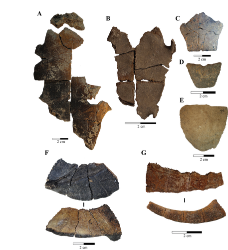
Zooarchaeological investigation of the Hoabinhian exploitation of reptiles and amphibians in Thailand and Cambodia with a focus on the Yellow-headed tortoise (Indotestudo elongata (Blyth, 1854))A zooarchaeological perspective on testudine bones from Hoabinhian hunter-gatherer archaeological assemblages in Southeast AsiaRecommended by Ruth Blasco based on reviews by Noel Amano and Iratxe Boneta
The study of the evolution of the human diet has been a central theme in numerous archaeological and paleoanthropological investigations. By reconstructing diets, researchers gain deeper insights into how humans adapted to their environments. The analysis of animal bones plays a crucial role in extracting dietary information. Most studies involving ancient diets rely heavily on zooarchaeological examinations, which, due to their extensive history, have amassed a wealth of data. During the Pleistocene–Holocene periods, testudine bones have been commonly found in a multitude of sites. The use of turtles and tortoises as food sources appears to stretch back to the Early Pleistocene [1-4]. More importantly, these small animals play a more significant role within a broader debate. The exploitation of tortoises in the Mediterranean Basin has been examined through the lens of optimal foraging theory and diet breadth models (e.g. [5-10]). According to the diet breadth model, resources are incorporated into diets based on their ranking and influenced by factors such as net return, which in turn depends on caloric value and search/handling costs [11]. Within these theoretical frameworks, tortoises hold a significant position. Their small size and sluggish movement require minimal effort and relatively simple technology for procurement and processing. This aligns with optimal foraging models in which the low handling costs of slow-moving prey compensate for their small size [5-6,9]. Tortoises also offer distinct advantages. They can be easily transported and kept alive, thereby maintaining freshness for deferred consumption [12-14]. For example, historical accounts suggest that Mexican traders recognised tortoises as portable and storable sources of protein and water [15]. Furthermore, tortoises provide non-edible resources, such as shells, which can serve as containers. This possibility has been discussed in the context of Kebara Cave [16] and noted in ethnographic and historical records (e.g. [12]). However, despite these advantages, their slow growth rate might have rendered intensive long-term predation unsustainable. While tortoises are well-documented in the Southeast Asian archaeological record, zooarchaeological analyses in this region have been limited, particularly concerning prehistoric hunter-gatherer populations that may have relied extensively on inland chelonian taxa. With the present paper Bochaton et al. [17] aim to bridge this gap by conducting an exhaustive zooarchaeological analysis of turtle bone specimens from four Hoabinhian hunter-gatherer archaeological assemblages in Thailand and Cambodia. These assemblages span from the Late Pleistocene to the first half of the Holocene. The authors focus on bones attributed to the yellow-headed tortoise (Indotestudo elongata), which is the most prevalent taxon in the assemblages. The research include osteometric equations to estimate carapace size and explore population structures across various sites. The objective is to uncover human tortoise exploitation strategies in the region, and the results reveal consistent subsistence behaviours across diverse locations, even amidst varying environmental conditions. These final proposals suggest the possibility of cultural similarities across different periods and regions in continental Southeast Asia. In summary, this paper [17] represents a significant advancement in the realm of zooarchaeological investigations of small prey within prehistoric communities in the region. While certain approaches and issues may require further refinement, they serve as a comprehensive and commendable foundation for assessing human hunting adaptations.
References [1] Hartman, G., 2004. Long-term continuity of a freshwater turtle (Mauremys caspica rivulata) population in the northern Jordan Valley and its paleoenvironmental implications. In: Goren-Inbar, N., Speth, J.D. (Eds.), Human Paleoecology in the Levantine Corridor. Oxbow Books, Oxford, pp. 61-74. https://doi.org/10.2307/j.ctvh1dtct.11 [2] Alperson-Afil, N., Sharon, G., Kislev, M., Melamed, Y., Zohar, I., Ashkenazi, R., Biton, R., Werker, E., Hartman, G., Feibel, C., Goren-Inbar, N., 2009. Spatial organization of hominin activities at Gesher Benot Ya'aqov, Israel. Science 326, 1677-1680. https://doi.org/10.1126/science.1180695 [3] Archer, W., Braun, D.R., Harris, J.W., McCoy, J.T., Richmond, B.G., 2014. Early Pleistocene aquatic resource use in the Turkana Basin. J. Hum. Evol. 77, 74-87. https://doi.org/10.1016/j.jhevol.2014.02.012 [4] Blasco, R., Blain, H.A., Rosell, J., Carlos, D.J., Huguet, R., Rodríguez, J., Arsuaga, J.L., Bermúdez de Castro, J.M., Carbonell, E., 2011. Earliest evidence for human consumption of tortoises in the European Early Pleistocene from Sima del Elefante, Sierra de Atapuerca, Spain. J. Hum. Evol. 11, 265-282. https://doi.org/10.1016/j.jhevol.2011.06.002 [5] Stiner, M.C., Munro, N., Surovell, T.A., Tchernov, E., Bar-Yosef, O., 1999. Palaeolithic growth pulses evidenced by small animal exploitation. Science 283, 190-194. https://doi.org/10.1126/science.283.5399.190 [6] Stiner, M.C., Munro, N.D., Surovell, T.A., 2000. The tortoise and the hare: small-game use, the Broad-Spectrum Revolution, and paleolithic demography. Curr. Anthropol. 41, 39-73. https://doi.org/10.1086/300102 [7] Stiner, M.C., 2001. Thirty years on the “Broad Spectrum Revolution” and paleolithic demography. Proc. Natl. Acad. Sci. U. S. A. 98 (13), 6993-6996. https://doi.org/10.1073/pnas.121176198 [8] Stiner, M.C., 2005. The Faunas of Hayonim Cave (Israel): a 200,000-Year Record of Paleolithic Diet. Demography and Society. American School of Prehistoric Research, Bulletin 48. Peabody Museum Press, Harvard University, Cambridge. [9] Stiner, M.C., Munro, N.D., 2002. Approaches to prehistoric diet breadth, demography, and prey ranking systems in time and space. J. Archaeol. Method Theory 9, 181-214. https://doi.org/10.1023/A:1016530308865 [10] Blasco, R., Cochard, D., Colonese, A.C., Laroulandie, V., Meier, J., Morin, E., Rufà, A., Tassoni, L., Thompson, J.C. 2022. Small animal use by Neanderthals. In Romagnoli, F., Rivals, F., Benazzi, S. (eds.), Updating Neanderthals: Understanding Behavioral Complexity in the Late Middle Palaeolithic. Elsevier Academic Press, pp. 123-143. ISBN 978-0-12-821428-2. https://doi.org/10.1016/C2019-0-03240-2 [11] Winterhalder, B., Smith, E.A., 2000. Analyzing adaptive strategies: human behavioural ecology at twenty-five. Evol. Anthropol. 9, 51-72. https://doi.org/10.1002/(sici)1520-6505(2000)9:2%3C51::aid-evan1%3E3.0.co;2-7 [12] Schneider, J.S., Everson, G.D., 1989. The Desert Tortoise (Xerobates agassizii) in the Prehistory of the Southwestern Great Basin and Adjacent areas. J. Calif. Gt. Basin Anthropol. 11, 175-202. http://www.jstor.org/stable/27825383 [13] Thompson, J.C., Henshilwood, C.S., 2014b. Nutritional values of tortoises relative to ungulates from the Middle Stone Age levels at Blombos Cave, South Africa: implications for foraging and social behaviour. J. Hum. Evol. 67, 33-47. https://doi.org/10.1016/j.jhevol.2013.09.010 [14] Blasco, R., Rosell, J., Smith, K.T., Maul, L.Ch., Sañudo, P., Barkai, R., Gopher, A. 2016. Tortoises as a Dietary Supplement: a view from the Middle Pleistocene site of Qesem Cave, Israel. Quat Sci Rev 133, 165-182. https://doi.org/10.1016/j.quascirev.2015.12.006 [15] Pepper, C., 1963. The truth about the tortoise. Desert Mag. 26, 10-11. [16] Speth, J.D., Tchernov, E., 2002. Middle Paleolithic tortoise use at Kebara Cave (Israel). J. Archaeol. Sci. 29, 471-483. https://doi.org/10.1006/jasc.2001.0740 [17] Bochaton, C., Chantasri, S., Maneechote, M., Claude, J., Griggo, C., Naksri, W., Forestier, H., Sophady, H., Auertrakulvit, P., Bowonsachoti, J. and Zeitoun, V. (2023) Zooarchaeological investigation of the Hoabinhian exploitation of reptiles and amphibians in Thailand and Cambodia with a focus on the Yellow-headed Tortoise (Indotestudo elongata (Blyth, 1854)), BioRXiv, 2023.04.27.538552 , ver. 3 peer-reviewed and recommended by Peer Community in Archaeology. https://doi.org/10.1101/2023.04.27.538552v3 | Zooarchaeological investigation of the Hoabinhian exploitation of reptiles and amphibians in Thailand and Cambodia with a focus on the Yellow-headed tortoise (*Indotestudo elongata* (Blyth, 1854)) | Corentin Bochaton, Sirikanya Chantasri, Melada Maneechote, Julien Claude, Christophe Griggo, Wilailuck Naksri, Hubert Forestier, Heng Sophady, Prasit Auertrakulvit, Jutinach Bowonsachoti, Valery Zeitoun | <p style="text-align: justify;">While non-marine turtles are almost ubiquitous in the archaeological record of Southeast Asia, their zooarchaeological examination has been inadequately pursued within this tropical region. This gap in research hind... | | Asia, Taphonomy, Zooarchaeology | Ruth Blasco | Iratxe Boneta, Noel Amano | 2023-05-02 09:30:50 |


