Latest recommendations

| Id | Title | Authors▲ | Abstract | Picture | Thematic fields | Recommender | Reviewers | Submission date | |
|---|---|---|---|---|---|---|---|---|---|
06 Aug 2023
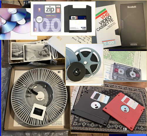
A Focus on the Future of our Tiny Piece of the Past: Digital Archiving of a Long-term Multi-participant Regional ProjectA meticulous description of archiving research data from a long-running landscape research projectRecommended by Isto Huvila based on reviews by Dominik Hagmann and Iwona DudekThe paper “A Focus on the Future of our Tiny Piece of the Past: Digital Archiving of a Long-term Multi-participant Regional Project” (Madry et al., 2023) describes practices, challenges and opportunities encountered in digital archiving of a landscape research project running in Burgundy, France for more than 45 years. As an unusually long-running multi-disciplinary undertaking working with a large variety of multi-modal digital and non-digital data, the Burgundy project has lived through the development of documentation and archiving technologies from the 1970s until today and faced many of the challenges relating to data management, preservation and migration. The major strenght of the paper is that it provides a detailed description of the evolution of digital data archiving practices in the project including considerations about why some approaches were tested and abandoned. This differs from much of the earlier literature where it has been more common to describe individual solutions how digital archiving was either planned or was performed at one point of time. A longitudinal description of what was planned, how and why it has worked or failed so far, as described in the paper, provides important insights in the everyday hurdles and ways forward in digital archiving. As a description of a digital archiving initiative, the paper makes a valuable contribution for the data archiving scholarship as a case description of practices and considerations in one research project. For anyone working with data management in a research project either as a researcher or data manager, the text provides useful advice on important practical matters to consider ahead, during and after the project. The main advice the authors are giving, is to plan and act for data preservation from the beginning of the project rather than doing it afterwards. To succeed in this, it is crucial to be knowledgeable of the key concepts of data management—such as “digital data fixity, redundant backups, paradata, metadata, and appropriate keywords” as the authors underline—including their rationale and practical implications. The paper shows also that when and if unexpected issues raise, it is important to be open for different alternatives, explore ways forward, and in general be flexible. The paper makes also a timely contribution to the discussion started at the session “Archiving information on archaeological practices and work in the digital environment: workflows, paradata and beyond” at the Computer Applications and Quantitative 2023 conference in Amsterdam where it was first presented. It underlines the importance of understanding and communicating the premises and practices of how data was collected (and made) and used in research for successful digital archiving, and the similar pertinence of documenting digital archiving processes to secure the keeping, preservation and effective reuse of digital archives possible. ReferencesMadry, S., Jansen, G., Murray, S., Jones, E., Willcoxon, L. and Alhashem, E. (2023) A Focus on the Future of our Tiny Piece of the Past: Digital Archiving of a Long-term Multi-participant Regional Project, Zenodo, 7967035, ver. 3 peer-reviewed and recommended by Peer Community in Archaeology. https://doi.org/10.5281/zenodo.7967035 | A Focus on the Future of our Tiny Piece of the Past: Digital Archiving of a Long-term Multi-participant Regional Project | Scott Madry, Gregory Jansen, Seth Murray, Elizabeth Jones, Lia Willcoxon, Ebtihal Alhashem | <p>This paper will consider the practical realities that have been encountered while seeking to create a usable Digital Archiving system of a long-term and multi-participant research project. The lead author has been involved in archaeologic... | | Computational archaeology, Environmental archaeology, Landscape archaeology | Isto Huvila | 2023-05-24 18:46:34 | ||
16 Apr 2024
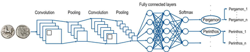
Creating an Additional Class Layer with Machine Learning to counter Overfitting in an Unbalanced Ancient Coin DatasetA significant contribution to the problem of unbalanced data in machine learning research in archaeologyRecommended by Alex Brandsen based on reviews by Simon Carrignon, Joel Santos and 1 anonymous reviewer based on reviews by Simon Carrignon, Joel Santos and 1 anonymous reviewer
This paper [1] presents an innovative approach to address the prevalent challenge of unbalanced datasets in coin type recognition, shifting the focus from coin class type recognition to coin mint recognition. Despite this shift, the issue of unbalanced data persists. To mitigate this, the authors introduce a method to split larger classes into smaller ones, integrating them into an 'additional class layer'. Three distinct machine learning (ML) methodologies were employed to identify new possible classes, with one approach utilising unsupervised clustering alongside manual intervention, while the others leverage object detection, and Natural Language Processing (NLP) techniques. However, despite these efforts, overfitting remained a persistent issue, prompting the authors to explore alternative methods such as dataset improvement and Generative Adversarial Networks (GANs). The paper contributes significantly to the intersection of ML techniques and archaeology, particularly in addressing overfitting challenges. Furthermore, the authors' candid acknowledgment of the limitations of their approaches serves as a valuable resource for researchers encountering similar obstacles. This study stems from the D4N4 project, aimed at developing a machine learning-based coin recognition model for the extensive "Corpus Nummorum" dataset, comprising over 19,600 coin types and 49,000 coins from various ancient landscapes. Despite encountering challenges with overfitting due to the dataset's imbalance, the authors' exploration of multiple methodologies and transparent documentation of their limitations enriches the academic discourse and provides a foundation for future research in this field. Reference [1] Gampe, S. and Tolle, K. (2024). Creating an Additional Class Layer with Machine Learning to counter Overfitting in an Unbalanced Ancient Coin Dataset. Zenodo, 8298077, ver. 4 peer-reviewed and recommended by Peer Community in Archaeology. https://doi.org/10.5281/zenodo.8298077 | Creating an Additional Class Layer with Machine Learning to counter Overfitting in an Unbalanced Ancient Coin Dataset | Sebastian Gampe, Karsten Tolle | <p>We have implemented an approach based on Convolutional Neural Networks (CNN) for mint recognition for our Corpus Nummorum (CN) coin dataset as an alternative to coin type recognition, since we had too few instances for most of the types (classe... | | Computational archaeology | Alex Brandsen | 2023-08-29 16:26:41 | ||
24 Jun 2021
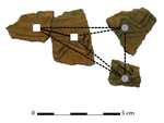
The strength of parthood ties. Modelling spatial units and fragmented objects with the TSAR method – Topological Study of Archaeological RefittingA practical computational approach to stratigraphic analysis using conjoinable material culture.Recommended by Hector A. Orengo based on reviews by Robert Bischoff, Matthew Peeples and 1 anonymous reviewerThe paper by Plutniak [1] presents a new method that uses refitting to help interpret stratigraphy using the topological distribution of conjoinable material culture. This new method opens up new avenues to the archaeological use of network analysis but also to assess the integrity of interpreted excavation layers. Beyond its evident applicability to standard excavation practice, the paper presents a series of characteristics that exemplify archaeological publication best practices and, as someone more versed in computational than in refitting studies I would like to comment upon. It was no easy task to find adequate reviewers for this paper as it combines techniques and expertise that are not commonly found together in individual researchers. However, Plutniak, with help from three reviewers, particularly M. Peeples, a leading figure in archaeological applications of network science, makes a considerable effort to be accessible to non-specialist archaeologists. The core Topological Study of Archaeological Refitting (TSAR) method is freely accessible as the R package archeofrag, which is available at the Comprehensive R Archive Network (https://CRAN.R-project.org/package=archeofrag) that can be applied without the need to understand all its mathematical, graph theory and coding aspects. Beside these, an online interface including test data has been provided (https://analytics.huma-num.fr/Sebastien.Plutniak/archeofrag/), which aims to ease access to the method to those archaeologists inexperienced with R. Finally, supplementary material showing how to use the package and evaluating its potential through excellent examples is provided as both pdf and Rmw (Sweave) files. This is an important companion for the paper as it allows a better understanding of the methods presented in the paper and its practical application. The author shows particular care in testing the potential and capabilities of the method. For example, a function is provided “frag.observer.failure” to test the robustness of the edge count method against the TSAR method, which is able to prove that TSAR can deal well with incomplete information. As a further step in this direction both simulated and real field-acquired data are used to test the method which further proves that archeofrag is not only able to quantitatively assess the mixture of excavated layers but to propose meaningful alternatives, which no doubt will add an increased methodological consistency and thoroughness to previous quantitative approaches to material refitting work, even when dealing with very complex stratigraphies. All in all, this paper makes an important contribution to core archaeological practice through the use of innovative, reproducible and accessible computational methods. I fully endorse it for the conscious and solid methods it presents but also for its adherence to open publication practices. I hope that it can become of standard use in the reconstruction of excavated stratigraphical layers through conjoinable material culture.
[1] Plutniak, S. 2021. The Strength of Parthood Ties. Modelling Spatial Units and Fragmented Objects with the TSAR Method – Topological Study of Archaeological Refitting. OSF Preprints, q2e69, ver. 3 Peer-reviewed and recommended by PCI Archaeology. https://doi.org/10.31219/osf.io/q2e69. | The strength of parthood ties. Modelling spatial units and fragmented objects with the TSAR method – Topological Study of Archaeological Refitting | Sébastien Plutniak | <p>Refitting and conjoinable pieces have long been used in archaeology to assess the consistency of discrete spatial units, such as layers, and to evaluate disturbance and post-depositional processes. The majority of current methods, despite their... | | Computational archaeology, Taphonomy | Hector A. Orengo | 2021-01-14 18:31:01 | ||
26 Sep 2022
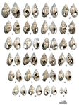
The management of symbolic raw materials in the Late Upper Paleolithic of South-Western France: a shell ornaments perspectiveCaching up with the study of the procurement of symbolic raw materials in the Upper PalaeolithicRecommended by Beatrice Demarchi based on reviews by Begoña Soler Mayor , Catherine Dupont and Lawrence StrausThe manuscript "The management of symbolic raw materials in the Late Upper Paleolithic of South-Western France: a shell ornaments perspective" by Solange Rigaud and colleagues (Rigaud et al. 2022) is a perfect demonstration that appropriate scientific methodologies can be used effectively in order to enhance the historical value of findings from “old” collections, despite the lack of secure stratigraphic and contextual data. The shell assemblage (n = 377) investigated here (from Rochereil, Dordogne) had been excavated during the first half of the 20th century (Jude 1960) and reported in 1993 (Taborin 1993), but only this recent analysis revealed that it was composed of largely unmodified mollusc shells, most of allochthonous origin. Rigaud et al. interpret this finding as the raw materials used to produce personal ornaments. This is especially significant, because the focus of research has been on the manufacture, use and exchange of personal ornaments in prehistory, much less so on the procurement of the raw materials. As such, the manuscript adds substantially to the growing literature on Magdalenian social networks. The authors carried out detailed taxonomic analysis based on morphological and morphometric characteristics and identified at least nine different species, including Dentalium sp., Ocenebra erinaceus, Tritia reticulata and T. gibbosula, as well as some bivalve specimens (Mytilus, Glycymeris, Spondylus, Pecten). Most of the species are commonly found in personal ornament assemblages from the Magdalenian, reflecting intentional selection (also shown by the size sorting of some of the taxa), and cultural continuity. However, microscopic examinations revealed securely-identified anthropogenic modifications on a very limited number of specimens: one Glycymeris valve (used as an ochre container), one Cardiidae valve (presence of a groove), one perforated Tritia gibbosula and two perforated Tritia reticulata bearing striations. The authors interpret this combination of anthropogenic vs natural “signals” as signifying that the assemblage represents raw material selected and stored for further processing. Assessing the provenance and age of the shells is therefore paramount: the shells found at Rochereil belong to species that can be found on both the Atlantic and Mediterranean coasts. Assuming that molluscan taxa distribution in the past is comparable to that for the present day, this implies the exploitation of two catchment areas and long-distance transportation to the site: taking sea-level changes into account, during the Magdalenian the Mediterranean used to lie at a distance of 350 km from Rochereil, and the Atlantic was not significantly closer (~200 km). Importantly, exploitation of fossil shells cannot be discounted on the basis of the data presented here; direct dating of some of the specimens (e.g. by radiocarbon, or amino acid racemisation geochronology) would be beneficial to clarify this issue and in general to improve chronological control on the accumulation of shells. Nonetheless, the authors argue that the closest fossil deposits also lie more than 200 km away from the site, thus the material is allochthonous in origin. In synthesis, the Rochereil assemblage represents an important step towards a better understanding of the procurement chain and of the production of ornaments during the European Upper Palaeolithic. References Jude, P. E. (1960). La grotte de Rocherreil: station magdalénienne et azilienne, Masson. Rigaud, S., O'Hara, J., Charles, L., Man-Estier, E. and Paillet, P. (2022) The management of symbolic raw materials in the Late Upper Paleolithic of South-Western France: a shell ornaments perspective. SocArXiv, z7pqg, ver. 4 peer-reviewed and recommended by Peer community in Archaeology. https://doi.org/10.31235/osf.io/z7pqg Taborin, Y. (1993). La parure en coquillage au Paléolithique, CNRS éditions. | The management of symbolic raw materials in the Late Upper Paleolithic of South-Western France: a shell ornaments perspective | Solange Rigaud, John O’Hara, Laurent Charles, Elena Man-Estier, Patrick Paillet | <p>Personal ornaments manufactured on marine and fossil shell are a significant element of Upper Palaeolithic symbolic material culture, and are often found at considerable distances from Pleistocene coastlines or relevant fossil deposits. Here, w... | | Europe, Symbolic behaviours, Upper Palaeolithic | Beatrice Demarchi | 2022-04-23 19:20:02 | ||
02 May 2023
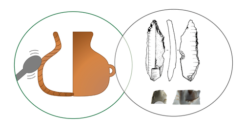
Transmission of lithic and ceramic technical know-how in the Early Neolithic of central-western Europe: Shedding Light on the Social Mechanisms underlying Cultural TransitionA Thought Provoking Consideration of Craft in the NeolithicRecommended by Clare Burke based on reviews by Bogdana Milić and 1 anonymous reviewerThe pioneering work of Leroi-Gourhan introduced archaeologists to the concept of the chaîne opératoire[1], whereby, like his supervisor Mauss[2], Leroi-Gourhan proposed direct links between bodily actions and aspects of cultural identity. The chaîne opératoire offers a powerful conceptual tool with which to reconstruct and describe the technological practices undertaken by craftspeople, linking material objects to the cultural context in which crafts are learnt. Although initially applied to lithics, the concept today is well known in ceramic studies, as well as, other material crafts, in order to identify aspects of tradition and identity through ideas linked to technological style[3,4] and communities of practice[5]. Utilizing this approach, Denis et al.[6] use the chaîne opératoire to look at both lithics and ceramics together from a diachronic viewpoint, to examine technical systems present over the transition between Linearbandkeramic (LBK) and post LBK Blicquy/Villeneuve-Saint German (BQY/VSG) timeframes. This much needed comparative and diachronic perspective, focuses on material from the sites of Vaux-et-Borset and Verlaine in Belgium, and has enabled the authors to consider the impact of changing social dynamics on these two crafts simultaneously. The authors examine the ceramic and lithic assemblages from a macroscopic and morphological perspective in order to identify techniques of production. The data gathered testifies to the dominance of one production technique for each craft within the LBK. There is particularly striking homogeneity noted for the lithics that suggests the transmission of a single tradition over the Hesbaye area, whilst the ceramics display greater regional diversity. The picture alters somewhat for the BQY/VSG material where it seems there is an increase in the diversity of production techniques, with both the introduction of new techniques, as well as a degree of hybridization of earlier techniques to form new BQY/VSG chaînes opératoires that have LBK roots. The BQY/VSG diversity noted for the lithics is especially interesting, with the introduction of techniques that attest to increased expertise which the authors attest to the migration of an external group. The results of this work have allowed Denis et al. to discuss multiple influences on the technical systems they identify. Rather than trying to fit the data within a single model, the authors demonstrate the need for nuance, considering the social changes associated with Neolithic migration and interactions, as multifaced and dynamic. As such, they are able to show not only the influence of contact with other groups, but that the apparent migration of external groups does not simply lead to the replacement of the crafting heritage already established at the sites they have examined. In concluding the authors acknowledge, that as scholars push the existing state of knowledge (in this respect analysis of raw materials would make an especially important contribution), the picture presented in the paper may alter. Future work will hopefully fill in current gaps, particularly in terms of how far the trends identified extend, and the extent to which the lithic and ceramic pictures diversify on a broader geographical scale. It is certain that based on such results, future work should adopt the comparative approach presented by the authors, who have demonstrated its explanatory potential for understanding the technical and cultural groups we all study. [2] Mauss, M. 2009 [1934]. Techniques, Technology and Civilisation. Edited and introduced by N. Schlanger. New York/Oxford: Durkheim Press/Berghahn Books. [3] Lechtman, H. 1977. Style in Technology: some early thoughts. In H. Lechtman and R.S. Merrill (eds.) Material Culture: styles, organization and dynamics of technology. Proceedings of the American Ethnological Society 1975, St. Paul, 3-20. [4] Gosselain, O. 1992. Technology and Style: Potters and Pottery Among Bafia of Cameroon. Man 27(3) 559- 586. htpps://doi.org/10.2307/2803929. [5] Wenger, E. 1998. Communities of practice: Learning, meaning, and identity. Cambridge: Cambridge University Press. [6] Denis, S., Gomart, L., Burnez-Lanotte, L. and Allard, P. (2023). Transmission of lithic and ceramic technical know-how in the Early Neolithic of central-western Europe: Shedding Light on the Social Mechanisms underlying Cultural Transition. OSF Preprints, gqnht, ver. 5 peer-reviewed and recommended by Peer Community in Archaeology. https://doi.org/10.31219/osf.io/gqnht
| Transmission of lithic and ceramic technical know-how in the Early Neolithic of central-western Europe: Shedding Light on the Social Mechanisms underlying Cultural Transition | Solène Denis, Louise Gomart, Laurence Burnez-Lanotte, Pierre Allard | <p>Research on the European Neolithisation agrees that a process of colonisation throughout the sixth millennium BC underlies the spread of agricultural ways of life on the continent. From central to central-western Europe, this colonisation path ... | | Ceramics, Europe, Lithic technology, Neolithic | Clare Burke | 2022-11-18 12:03:55 | ||
01 Dec 2021
A closer look at an eroded dune landscape: first functional insights into the Federmessergruppen site of Lommel-MaatheidePotential of a large-scale functional analysis to reconstructing past human activities at the Final Palaeolithic site of Lommel-MaatheideRecommended by Marta Arzarello and Alice Leplongeon based on reviews by Gabriele Luigi Francesco Berruti and Ana Abrunhosa
The paper “A closer look at an eroded dune landscape: first functional insights into the Federmessergruppen site of Lommel-Maatheide” [1] focuses on the final Palaeolithic (Federmesser) site of Lommel-Maatheide. Federmesser sites from northern Belgium such as Lommel-Maatheide, Meer and Rekem, show evidence for dense human occupation of specific areas located on top of Tardiglacial dunes nearby water bodies [2]. Preserved spatial distribution of finds at the sites suggest different activity areas and the presence of habitat structures [2]. However, because of the low organic preservation at the sites, functional analyses of lithic assemblages have the potential to significantly contribute to the spatial organisation of activities at these sites. This study by Tomasso et al. [1], represents an excellent example of a large-scale integrated approach to the study of lithic industries. The article undoubtedly demonstrates the potential of the proposed methodology and the reliability of the results obtained. The article explores two different aspects (linked and excellently interconnected here): the possibility to apply use wear, residue and fracture analyses, on lithic assemblages affected by taphonomical alterations and to study lithic assemblages from dune landscapes. The study allows to answer differentiated questions: what is the influence of taphonomical alterations on use wear analysis? How do excavation methods impact the formation of use wear and the preservation of residues? Can we recognize distinct domestic activities? The article also provides an interesting hypothesis about hunting activities and propulsion methods. The applied methodology is effectively interdisciplinary and innovative. It demonstrates how a truly integrated and articulated approach can represent the turning point for going beyond a mainly descriptive dimension to move towards a real understanding of the sites. Studies dedicated to the analysis of the propulsion mode are not very frequent, but they are surely very important to better understand human behaviour [3]. Here, the methodology developed for the evaluation of the propulsion mode represent an important starting point for the definition of a new approach. Morphological and morphometrical analysis are integrated to the evaluation of the mechanical stress, to fracture delineations and to the hafting system (the latter defined on experimental basis). This article therefore underlines the potential of combining different approaches to functional analysis associated with a ‘tailored’ reference collection and applying them to a high number of artefacts for reconstructing past human activities involving materials that are otherwise not preserved in these contexts. [1] Tomasso, S., Cnuts, D., Coppe, J., Geerts, F., Gils, M.V., Bie, M.D., Rots, V. (2021). A closer look at an eroded dune landscape: first functional insights into the Federmessergruppen site of Lommel-Maatheide. https://doi.org/10.31219/osf.io/pf3sm, ver 3 peer-reviewed and recommended by PCI Archaeology. [2] De Bie, M., Van Gils, M. (2006). Les habitats des groupes à Federmesser (aziliens) dans le Nord de la Belgique. Bulletin de la Société préhistorique française, 103, 781–790. [3] Coppe, J., Lepers, C., Clarenne, V., Delaunois, E., Pirlot, M. and Rots V. (2019). Ballistic Study Tackles Kinetic Energy Values of Palaeolithic Weaponry. Archaeometry, (61)4, 933-956. https://doi.org/10.1111/arcm.12452 | A closer look at an eroded dune landscape: first functional insights into the Federmessergruppen site of Lommel-Maatheide | Sonja Tomasso, Dries Cnuts, Justin Coppe, Marijn Van Gils, Ferdi Geerts, Marc De Bie, Veerle Rots | <p>The vast Federmessergruppen site of Lommel-Maatheide, which is located in the Campine region (Northern Belgium), revealed the presence of numerous Final Palaeolithic concentrations situated on a large Late Glacial sand ridge on the northern edg... | | Environmental archaeology, Landscape archaeology, Lithic technology, Traceology, Upper Palaeolithic | Marta Arzarello | 2021-09-14 17:04:38 | ||
23 Nov 2023
Percolation Package - From script sharing to package publicationSharing Research Code in ArchaeologyRecommended by James Allison based on reviews by Thomas Rose, Joe Roe and 1 anonymous reviewer
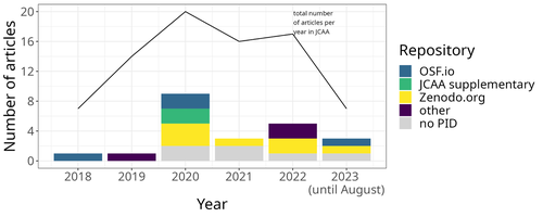
The paper “Percolation Package – From Script Sharing to Package Publication” by Sophie C. Schmidt and Simon Maddison (2023) describes the development of an R package designed to apply Percolation Analysis to archaeological spatial data. In an earlier publication, Maddison and Schmidt (2020) describe Percolation Analysis and provide case studies that demonstrate its usefulness at different spatial scales. In the current paper, the authors use their experience collaborating to develop the R package as part of a broader argument for the importance of code sharing to the research process. The paper begins by describing the development process of the R package, beginning with borrowing code from a geographer, refining it to fit archaeological case studies, and then collaborating to further refine and systematize the code into an R package that is more easily reusable by other researchers. As the review by Joe Roe noted, a strength of the paper is “presenting the development process as it actually happens rather than in an idealized form.” The authors also include a section about the lessons learned from their experience. Moving on from the anecdotal data of their own experience, the authors also explore code sharing practices in archaeology by briefly examining two datasets. One dataset comes from “open-archaeo” (https://open-archaeo.info/), an on-line list of open-source archaeological software maintained by Zack Batist. The other dataset includes articles published between 2018 and 2023 in the Journal of Computer Applications in Archaeology. Schmidt and Maddison find that these two datasets provide contrasting views of code sharing in archaeology: many of the resources in the open-archaeo list are housed on Github, lack persistent object identifiers, and many are not easily findable (other than through the open-archaeo list). Research software attached to the published articles, on the other hand, is more easily findable either as a supplement to the published article, or in a repository with a DOI. The examination of code sharing in archaeology through these two datasets is preliminary and incomplete, but it does show that further research into archaeologists’ code-writing and code-sharing practices could be useful. Archaeologists often create software tools to facilitate their research, but how often? How often is research software shared with published articles? How much attention is given to documentation or making the software usable for other researchers? What are best (or good) practices for sharing code to make it findable and usable? Schmidt and Maddison’s paper provides partial answers to these questions, but a more thorough study of code sharing in archaeology would be useful. Differences among journals in how often they publish articles with shared code, or the effects of age, gender, nationality, or context of employment on attitudes toward code sharing seem like obvious factors for a future study to consider. Shared code that is easy to find and easy to use benefits the researchers who adopt code written by others, but code authors also have much to gain by sharing. Properly shared code becomes a citable research product, and the act of code sharing can lead to productive research collaborations, as Schmidt and Maddison describe from their own experience. The strength of this paper is the attention it brings to current code-sharing practices in archaeology. I hope the paper will also help improve code sharing in archaeology by inspiring more archaeologists to share their research code so other researchers can find and use (and cite) it. References Maddison, M.S. and Schmidt, S.C. (2020). Percolation Analysis – Archaeological Applications at Widely Different Spatial Scales. Journal of Computer Applications in Archaeology, 3(1), p.269–287. https://doi.org/10.5334/jcaa.54 Schmidt, S. C., and Maddison, M. S. (2023). Percolation Package - From script sharing to package publication, Zenodo, 7966497, ver. 3 peer-reviewed and recommended by Peer Community in Archaeology. https://doi.org/10.5281/zenodo.7966497 | Percolation Package - From script sharing to package publication | Sophie C Schmidt; Simon Maddison | <p>In this paper we trace the development of an R-package starting with the adaptation of code from a different field, via scripts shared between colleagues, to a published package that is being successfully used by researchers world-wide. Our aim... | | Computational archaeology | James Allison | 2023-05-24 15:40:15 | ||
03 Feb 2024
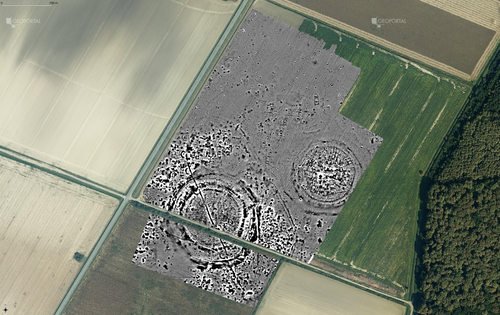
Digital surface models of crops used in archaeological feature detection – a case study of Late Neolithic site Tomašanci-Dubrava in Eastern CroatiaWhat lies on top lies also beneath? Connecting crop surface modelling to buried archaeology mapping.Recommended by Markos Katsianis based on reviews by Ian Moffat and Geert Verhoeven
This paper (Sosic et al. 2024) explores the Neolithic landscape of the Sopot culture in Đakovština, Eastern Slavonija, revealing a network of settlements through a multi-faceted approach that combines aerial archaeology, magnetometry, excavation, and field survey. This strategy facilitates scalable research tailored to the particularities of each site and allows for improved representations of buried archaeology with minimal intrusion. Using the site of Tomašanci-Dubrava as an example of the overall approach, the study further explores the use of drone imagery for 3D surface modeling, revealing a consistent correlation between crop surface elevation during full plant growth and ground terrain after ploughing, attributed to subsurface archaeological features. Results are correlated with magnetic survey and test-pitting data to validate the micro-topography and clarify the relationship between different subsurface structures. The results obtained are presented in a comprehensive way, including their source data, and are contextualized in relation to conventional cropmark detection approaches and expectations. I found this aspect very interesting, since the crop surface and terrain models contradict typical or textbook examples of cropmark detection, where the vegetation is projected to appear higher in ditches and lower in areas with buried archaeology (Renfrew & Bahn 2016, 82). Regardless, the findings suggest the potential for broader applications of crop surface or canopy height modelling in landscape wide surveys, utilizing ALS data or aerial photographs. It seems then that the authors make a valid argument for a layered approach in landscape-based site detection, where aerial imagery can be used to accurately map the topography of areas of interest, which can then be further examined at site scale using more demanding methods, such as geophysical survey and excavation. This scalability enhances the research's relevance in broader archaeological and geographical contexts and renders it a useful example in site detection and landscape-scale mapping. References Renfrew, C. and Bahn, P. (2016). Archaeology: theories, methods and practice. Thames and Hudson. Sosic Klindzic, R., Vuković, M., Kalafatić, H. and Šiljeg, B. (2024). Digital surface models of crops used in archaeological feature detection – a case study of Late Neolithic site Tomašanci-Dubrava in Eastern Croatia, Zenodo, 7970703, ver. 4 peer-reviewed and recommended by Peer Community in Archaeology. https://doi.org/10.5281/zenodo.7970703 | Digital surface models of crops used in archaeological feature detection – a case study of Late Neolithic site Tomašanci-Dubrava in Eastern Croatia | Sosic Klindzic Rajna; Vuković Miroslav; Kalafatić Hrvoje; Šiljeg Bartul | <p>This paper presents the results of a study on the neolithic landscape of the Sopot culture in the area of Đakovština in Eastern Slavonija. A vast network of settlements was uncovered using aerial archaeology, which was further confirmed and chr... | | Landscape archaeology, Neolithic, Remote sensing, Spatial analysis | Markos Katsianis | 2023-09-01 12:57:04 | ||
14 Nov 2023
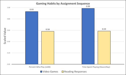
Student Feedback on Archaeogaming: Perspectives from a Classics ClassroomLearning with Archaeogaming? A study based on student feedbackRecommended by Sebastian Hageneuer based on reviews by Jeremiah McCall and 1 anonymous reviewer
This paper (Stephan 2023) is about the use of video games as a pedagogical tool in class. Instead of taking the perspective of a lecturer, the author seeks the student’s perspectives to evaluate the success of an interactive teaching method at the crossroads of history, archaeology, and classics. The paper starts with a literature review, that highlights the intensive use of video games among college students and high schoolers as well as the impact video games can have on learning about the past. The case study this paper is based on is made with the game Assassin’s Creed: Odyssey, which is introduced in the next part of the paper as well as previous works on the same game. The author then explains his method, which entailed the tasks students had to complete for a class in classics. They could either choose to play a video game or more classically read some texts. After the tasks were done, students filled out a 14-question-survey to collect data about prior gaming experience, assignment enjoyment, and other questions specific to the assignments. The results were based on only a fraction of the course participants (n=266) that completed the survey (n=26), which is a low number for doing statistical analysis. Besides some quantitative questions, students had also the possibility to freely give feedback on the assignments. Both survey types (quantitative answers and qualitative feedback) solely relied on the self-assessment of the students and one might wonder how representative a self-assessment is for evaluating learning outcomes. Both problems (size of the survey and actual achievements of learning outcomes) are getting discussed at the end of the paper, that rightly refers to its results as preliminary. I nevertheless think that this survey can help to better understand the role that video games can play in class. As the author rightly claims, this survey needs to be enhanced with a higher number of participants and a better way of determining the learning outcomes objectively. This paper can serve as a start into how we can determine the senseful use of video games in classrooms and what students think about doing so. References
Stephan, R. (2023). Student Feedback on Archaeogaming: Perspectives from a Classics Classroom, Zenodo, 8221286, ver. 6 peer-reviewed and recommended by Peer Community in Archaeology. https://doi.org/10.5281/zenodo.8221286
| Student Feedback on Archaeogaming: Perspectives from a Classics Classroom | Stephan, Robert | <p>This study assesses student feedback from the implementation of Assassin’s Creed: Odyssey as a teaching tool in a lower level, general education Classics course (CLAS 160B1 - Meet the Ancients: Gateway to Greece and Rome). In this course, which... | | Antiquity, Classic, Mediterranean | Sebastian Hageneuer | Anonymous, Jeremiah McCall | 2023-08-07 16:45:31 | |
12 Feb 2024
3Duewelsteene - A website for the 3D visualization of the megalithic passage grave Düwelsteene near Heiden in Westphalia, GermanyOnline presentation of the digital reconstruction process of a megalithic tomb : “3Duewelsteene”Recommended by Sophie C. Schmidt and James Allison based on reviews by Robert Bischoff, Ronald Visser and Scott Ure
“3Duewelsteene - A website for the 3D visualization of the megalithic passage grave Düwelsteene near Heiden in Westphalia, Germany” (Tharandt 2024) presents several 3-dimensional models of the Düwelsteene monument, along with contextual information about the grave and the process of creating the models. The website (https://3duewelsteene.github.io/) includes English and German versions, making it accessible to a wide audience. The website itself serves as the primary means of presenting the data, rather than as a supplement to a written text. This is an innovative and engaging way to present the research to a wider public. Düwelsteene (“Devil’s Stones”) is a megalithic passage grave from the Funnel Beaker culture, dating to approximately 3300 BC. to 2600 BC. that was excavated in 1932. The website displays three separate 3-dimensional models. They ares shown in the 3D viewer software 3DHOP, which enables viewers to interact with the models in several ways, Annotations on the models display further information. The first model was created by image-based modeling and shows the monument as it appears today. A second model uses historical photographs and excavation data to reconstruct the grave as it appeared prior to the 1932 archaeological excavation. Restoration work following the excavation relocated many of the stones. Pre-1932 photographs collected from residents of the nearby town of Heiden were then used to create a model showing what the tomb looked like before the restoration work. It is commendable that a “certainty view” of the model shows the certainty with which the stones can be put at the reconstructed place. Gaps in the 3D models of stones that were caused by overlap with other stones have been filled with a rough mesh and marked as such, thereby differentiating between known and unknown parts of the stones. The third model is the most imaginative and most interesting. As it shows as the grave as it might have appeared in approximately 3000 B.C., many aspects of this model are necessarily somewhat speculative. There is no direct evidence for exact size and shape of the capstones, the height of the mound, and other details. But enough is known about other similar constructions to allow these details to be inferred with some confidence. Again, care was taken to enable viewers to distinguish between the stones that are still in existence and those that were reconstructed. A video on the home page of the website adds a nice touch. It starts with the model of the Düwelsteene as it currently appears then shows, in reverse order, the changes to the grave, ending with the inferred original state. The 3D reconstructions are convincing and the methods well described. This project follows an open science approach and the FAIR principles, which is commendable and cutting edge in the field of Digital Archaeology. The preprint of the website hosted on zenodo includes all the photos, text, html files, and nine individual 3D model (.ply) files that are combined in the reconstructions exhibited on the website. A “readme.md” file includes details about building the models using CloudCompare and Blender, and modifications to the 3D viewer software (3DHOP) to get the website to improve the display of the reconstructions. We have to note that the link between the reconstructed models and the html page does not work when the files are downloaded from zenodo and opened offline. The html pages open in the browser, and the individual ply files work fine, but the 3D models do not display on the browser page when the html files are opened offline. The online version of the website is working perfectly. The 3Düwelsteene website combines the presentation of archaeological domain knowledge to a lay audience as well as in-depths information on the reconstruction process to make it an interesting contribution for researchers. By providing data and code for the website it also models an Open Science approach, which enables other researchers to re-use these materials. We congratulate the author on a successful reconstruction of the megalithic tomb, an admirable presentation of the archaeological work and the thoughtful outreach to a broad audience. Bibliography | 3Duewelsteene - A website for the 3D visualization of the megalithic passage grave Düwelsteene near Heiden in Westphalia, Germany | Tharandt, Louise | <p>The Düwelsteene near Heiden, Westphalia, is one of the most southern megalithic tombs of the Funnel Beaker culture. In 1932 the Düwelsteene were restored and the appearance of the grave was changed. Even though the megalithic tomb was excavated... | | Computational archaeology, Mesolithic, Neolithic | Sophie C. Schmidt | 2023-05-21 17:24:22 |


