Latest recommendations

| Id | Title | Authors | Abstract | Picture | Thematic fields | Recommender | Reviewers | Submission date▲ | |
|---|---|---|---|---|---|---|---|---|---|
11 Oct 2023
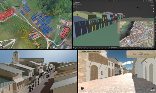
Transforming the Archaeological Record Into a Digital Playground: a Methodological Analysis of The Living Hill ProjectGamification of an archaeological park: The Living Hill Project as work-in-progressRecommended by Sebastian Hageneuer based on reviews by Andrew Reinhard, Erik Champion and 1 anonymous reviewer based on reviews by Andrew Reinhard, Erik Champion and 1 anonymous reviewer
This paper (2023) describes The Living Hill project dedicated to the archaeological park and fortress of Poggio Imperiale in Poggibonsi, Italy. The project is a collaboration between the Poggibonsi excavation and Entertainment Games App, Ltd. From the start, the project focused on the question of the intended audience rather than on the used technology. It was therefore planned to involve the audience in the creation of the game itself, which was not possible after all due to the covid pandemic. Nevertheless, the game aimed towards a visit experience as close as possible to reality to offer an educational tool through the video game, as it offers more periods than the medieval period showcased in the archaeological park itself. The game mechanics differ from a walking simulator, or a virtual tour and the player is tasked with returning three lost objects in the virtual game. While the medieval level was based on a 3D scan of the archaeological park, the other two levels were reconstructed based on archaeological material. Currently, only a PC version is working, but the team works on a mobile version as well and teased the possibility that the source code will be made available open source. Lastly, the team also evaluated the game and its perception through surveys, interviews, and focus groups. Although the surveys were only based on 21 persons, the results came back positive overall. The paper is well-written and follows a consistent structure. The authors clearly define the goals and setting of the project and how they developed and evaluated the game. Although it has be criticized that the game is not playable yet and the size of the questionnaire is too low, the authors clearly replied to the reviews and clarified the situation on both matters. They also attended to nearly all of the reviewers demands and answered them concisely in their response. In my personal opinion, I can fully recommend this paper for publication. For future works, it is recommended that the authors enlarge their audience for the quesstionaire in order to get more representative results. It it also recommended to make the game available as soon as possible also outside of the archaeological park. I would also like to thank the reviewers for their concise and constructive criticism to this paper as well as for their time. References Mariotti, Samanta. (2023) Transforming the Archaeological Record Into a Digital Playground: a Methodological Analysis of The Living Hill Project, Zenodo, 8302563, ver. 5 peer-reviewed and recommended by Peer Community in Archaeology https://doi.org/10.5281/zenodo.8302563 | Transforming the Archaeological Record Into a Digital Playground: a Methodological Analysis of *The Living Hill* Project | Samanta Mariotti | <p>Video games are now recognised as a valuable tool for disseminating and enhancing archaeological heritage. In Italy, the recent institutionalisation of Public Archaeology programs and incentives for digital innovation has resulted in a prolifer... | | Conservation/Museum studies, Europe, Medieval, Post-medieval | Sebastian Hageneuer | 2023-08-30 20:25:32 | ||
03 Nov 2023
The Dynamic Collections – a 3D Web Platform of Archaeological Artefacts designed for Data Reuse and Deep InteractionA comparative teaching and learning tool for 3D data: Dynamic CollectionsRecommended by Sebastian Hageneuer based on reviews by Alex Brandsen and Louise Tharandt
The paper (Callieri, M. et al. 2023) describes the “Dynamic Collections” project, an online platform initially created to showcase digital archaeological collections of Lund University. During a phase of testing by department members, new functionalities and artefacts were added resulting in an interactive platform adapted to university-level teaching and learning. The paper introduces into the topic and related works after which it starts to explain the project itself. The idea is to resemble the possibilities of interaction of non-digital collections in an online platform. Besides the objects themselves, the online platform offers annotations, measurement and other interactive tools based on the already known 3DHOP framework. With the possibility to create custom online collections a collaborative working/teaching environment can be created. The already wide-spread use of the 3DHOP framework enabled the authors to develop some functionalities that could be used in the “Dynamic Collections” project. Also, current and future plans of the project are discussed and will include multiple 3D models for one object or permanent identifiers, which are both important additions to the system. The paper then continues to explain some of its further planned improvements, like comparisons and support for teaching, which will make the tool an important asset for future university-level education. The paper in general is well-written and informative and introduces into the interactive tool, that is already available and working. It is very positive, that the authors rely on up-to-date methodologies in creating 3D online repositories and are in fact improving them by testing the tool in a teaching environment. They mention several times the alignment with upcoming EU efforts related to the European Collaborative Cloud for Cultural Heritage (ECCCH), which is anticipatory and far-sighted and adds to the longevity of the project. Comments of the reviewers were reasonably implemented and led to a clearer and more concise paper. I am very confident that this tool will find good use in heritage research and presentation as well as in university-level teaching and learning. Although the authors never answer the introductory question explicitly (What characteristics should a virtual environment have in order to trigger dynamic interaction?), the paper gives the implicit answer by showing what the "Dynamic Collections" project has achieved and is able to achieve in the future. BibliographyCallieri, M., Berggren, Å., Dell'Unto, N., Derudas, P., Dininno, D., Ekengren, F., and Naponiello, G. (2023). The Dynamic Collections – a 3D Web Platform of Archaeological Artefacts designed for Data Reuse and Deep Interaction, Zenodo, 10067103, ver. 3 peer-reviewed and recommended by Peer Community in Archaeology. https://doi.org/10.5281/zenodo.10067103 | The Dynamic Collections – a 3D Web Platform of Archaeological Artefacts designed for Data Reuse and Deep Interaction | Marco Callieri, Åsa Berggren, Nicolò Dell’Unto, Paola Derudas, Domenica Dininno, Fredrik Ekengren, Giuseppe Naponiello | <p>The Dynamic Collections project is an ongoing initiative pursued by the Visual Computing Lab ISTI-CNR in Italy and the Lund University Digital Archaeology Laboratory-DARKLab, Sweden. The aim of this project is to explore the possibilities offer... | | Archaeometry, Computational archaeology | Sebastian Hageneuer | 2023-08-31 15:05:32 | ||
02 Jan 2024
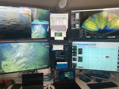
Advancing data quality of marine archaeological documentation using underwater robotics: from simulation environments to real-world scenariosBeyond Deep Blue: Underwater robotics, simulations and archaeologyRecommended by Daniel Carvalho based on reviews by Marco Moderato and 1 anonymous reviewerDiamanti et al. (2024) is a significant contribution to the field of underwater robotics and their use in archaeology, with an innovative approach to some major problems in the deployment of said technologies. It identifies issues when it comes to approaching Underwater Cultural Heritage (UCH) sites and does so through an interest in the combination of data, maneuverability, and the interpretation provided by the instruments that archaeologists operate. The article's motives are clear: it is not enough to find the means to reach these sites, but rather is fundamental to take a step forward in methodology and how we can safeguard certain aspects of data recovery with robust mission planning. To this end, the article does not fail to highlight previous contributions, in an intertwined web of references that demonstrate the marked evolution of the use of Unmanned Underwater Vehicles (UUVs), Remote Operated Vehicles (ROVs), Autonomous Underwater Vehicles (AUVs) and Autonomous Surface Vehicles (ASVs), which are growing exponentially in use (see Kapetanović et al. 2020). It should be emphasized that the notion of ‘aquatic environment’ used here is quite broad and is not limited to oceanic or maritime environments, which allows for a larger perspective on distinct technologies that proliferate in underwater archaeology. There is also a relevant discussion on the typologies of sensors and how these autonomous vehicles obtain their data, where are debated Inertial Measurement Units (IMU) and LiDAR systems. Thus, the authors of this article propose the creation of a model that acquires data through simulations, which allows for a better understanding of what a real mission presupposes in the field. Their tripartite method - pre-mission planning; mission plan and post-mission plan - offers a performing algorithm that simplifies and provides reliability to all the parts of the intervention. The use of real cases to create simulation models allows for a substantial approximation to common practice in underwater environments. And yet, the article is at its most innovative status when it combines all the elements it sets out to explore. It could simply focus on the methodological or planning component, on obtaining data, or on theoretical problems. But it goes further, which makes this approach more complete and of interest to the archaeological community. By not taking any part as isolated, the problems and possible solutions arising from the course of the mission are carried over from one parameter to another, where details are worked upon and efficiency goals are set. One of the most significant cases is the tuning of ocean optics in aquatic environments according to the idiosyncracies of real cases (Diamanti et al. 2024: 8), a complex endeavor but absolutely necessary in order to increase the informative potential of the simulation. The exploration of various data capture models is also welcome, for the purposes of comparison and adaptation on a case-by-case basis. The brief theoretical reflection offered at the end of the article dwells in all these points and problematizes the difference between terrestrial and aquatic archaeology. In fact, the distinction does not only exist in the technical component, as although it draws in theoretical elements from archaeology that is carried out on land (see Krieger 2012 for this matter), the problems and interpretations are shaped by different factors and therefore become unique (Diamanti et al 2024: 15). The future, according to the authors, lies in increasing the autonomy of these vehicles so that the human element does not have to make decisions in a systematic way. It is in that note, and in order for that path to become closer to reality, that we strongly recommend this article for publication, in conjunction with the comments of the reviewers. We hope that its integrated approach, which brings together methods, theories and reflections, can become a broader modus operandi within the field of underwater robotics applied to archaeology. References: Diamanti, E., Yip, M., Stahl, A. and Ødegård, Ø. (2024). Advancing data quality of marine archaeological documentation using underwater robotics: from simulation environments to real-world scenarios, Zenodo, 8305098, ver. 4 peer-reviewed and recommended by Peer Community in Archaeology. https://doi.org/10.5281/zenodo.8305098 Kapetanović, N., Vasilijević, A., Nađ, Đ., Zubčić, K., and Mišković, N. (2020). Marine Robots Mapping the Present and the Past: Unraveling the Secrets of the Deep. Remote Sensing, 12(23), 3902. MDPI AG. http://dx.doi.org/10.3390/rs12233902 Krieger, W. H. (2012). Theory, Locality, and Methodology in Archaeology: Just Add Water? HOPOS: The Journal of the International Society for the History of Philosophy of Science, 2(2), 243–257. https://doi.org/10.1086/666956
| Advancing data quality of marine archaeological documentation using underwater robotics: from simulation environments to real-world scenarios | Diamanti, Eleni; Yip, Mauhing; Stahl, Annette; Ødegård, Øyvind | <p>This paper presents a novel method for visual-based 3D mapping of underwater cultural heritage sites through marine robotic operations. The proposed methodology addresses the three main stages of an underwater robotic mission, specifically the ... | | Computational archaeology, Remote sensing | Daniel Carvalho | 2023-08-31 16:03:10 | ||
24 Jan 2024
Social Network Analysis, Community Detection Algorithms, and Neighbourhood Identification in PompeiiA Valuable Contribution to Archaeological Network Research: A Case Study of PompeiiRecommended by David Laguna-Palma based on reviews by Matthew Peeples, Isaac Ullah and Philip Verhagen
The paper entitled 'Social Network Analysis, Community Detection Algorithms, and Neighbourhood Identification in Pompeii' [1] presents a significant contribution to the field of archaeological network research, particularly in the challenging task of identifying urban neighborhoods within the context of Pompeii. This study focuses on the relational dynamics within urban neighborhoods and examines their indistinct boundaries through advanced analytical methods. The methodology employed provides a comprehensive analysis of community detection, including the Louvain and Leiden algorithms, and introduces a novel Convex Hull of Admissible Modularity Partitions (CHAMP) algorithm. The incorporation of a network approach into this domain is both innovative and timely. The potential impact of this research is substantial, offering new perspectives and analytical tools. This opens new avenues for understanding social structures in ancient urban settings, which can be applied to other archaeological contexts beyond Pompeii. Moreover, the manuscript is not only methodologically solid but also well-written and structured, making complex concepts accessible to a broad audience. In conclusion, this study represents a valuable contribution to the field of archaeology, particularly for archaeological network research. Their results not only enhance our knowledge of Pompeii but also provide a robust framework for future studies in similar historical contexts. Therefore, this publication advances our understanding of social dynamics in historical urban environments. The rigorous analysis, combined with the innovative application of network algorithms, makes this study a noteworthy addition to the existing body of network science literature. It is recommended for a wide range of scholars interested in the intersection of archaeology, history, and network science. Reference [1] Notarian, Matthew. 2024. Social Network Analysis, Community Detection Algorithms, and Neighbourhood Identification in Pompeii. https://doi.org/10.5281/zenodo.8305968 | Social Network Analysis, Community Detection Algorithms, and Neighbourhood Identification in Pompeii | Notarian, Matthew | <p>The definition and identification of urban neighbourhoods in archaeological contexts remain complex and problematic, both theoretically and empirically. As constructs with both social and spatial characteristics, their detection through materia... | | Antiquity, Classic, Computational archaeology, Mediterranean | David Laguna-Palma | 2023-08-31 19:28:35 | ||
02 Apr 2024
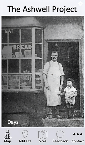
The Ashwell Project: Creating an Online Geospatial CommunityA nice project looking at under-represented demographicRecommended by Alexis Pantos based on reviews by Catriona Cooper and Steinar Kristensen
The paper by A. Lien-Talks [1] presents a small project looking at the use of crowd sourced data collection and particpatory GIS. In particular it looks at the potential of these tools in response to socially disruptive and isolating events such as the COVID-19 pandemic as well as the potential role of digitially mediated heritage initiatives in tackling some of the challenges of changing demographics and life styles. The types of technologies employed are relatively mature, the project identifies potential for such approaches to be used within the local-history/local community settings, though is also a reminer that depsite the much broader adoption of technology within all areas of society than even a few years ago many barriers still remain. While the the sample size and data collected in the project is relatively modest, the focus on empathy toward the intended audiences from the design process, as well as some of the qualitative feedback reported serve as a reminder that participatory, or crowd-sourced data collection initiatives in heritage can, and perhaps should place potential social benefit before data-acquisition of objectives. The project also presents a demographic that is not often represented within the literature and the publication and as such the publication of the article represents a meaningful contribution to ongoing discussions of the role heritage and digitally mediated community archaeology can play a role in developing our societies. References [1] Lien-Talks, A. (2024). The Ashwell Project: Creating an Online Geospatial Community. Zenodo, 8307882, ver. 4 peer-reviewed and recommended by Peer Community in Archaeology. https://doi.org/10.5281/zenodo.8307882 | The Ashwell Project: Creating an Online Geospatial Community | Alphaeus Lien-Talks | <p>Background:<br>As the world becomes increasingly digital, so too must the way in which archaeologists engage with the public. This was particularly important during the COVID-19 pandemic, and many outreach and engagement efforts began to move o... | | Computational archaeology | Alexis Pantos | 2023-09-01 11:25:54 | ||
03 Feb 2024
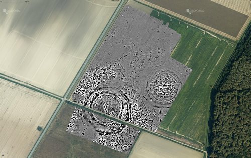
Digital surface models of crops used in archaeological feature detection – a case study of Late Neolithic site Tomašanci-Dubrava in Eastern CroatiaWhat lies on top lies also beneath? Connecting crop surface modelling to buried archaeology mapping.Recommended by Markos Katsianis based on reviews by Ian Moffat and Geert Verhoeven
This paper (Sosic et al. 2024) explores the Neolithic landscape of the Sopot culture in Đakovština, Eastern Slavonija, revealing a network of settlements through a multi-faceted approach that combines aerial archaeology, magnetometry, excavation, and field survey. This strategy facilitates scalable research tailored to the particularities of each site and allows for improved representations of buried archaeology with minimal intrusion. Using the site of Tomašanci-Dubrava as an example of the overall approach, the study further explores the use of drone imagery for 3D surface modeling, revealing a consistent correlation between crop surface elevation during full plant growth and ground terrain after ploughing, attributed to subsurface archaeological features. Results are correlated with magnetic survey and test-pitting data to validate the micro-topography and clarify the relationship between different subsurface structures. The results obtained are presented in a comprehensive way, including their source data, and are contextualized in relation to conventional cropmark detection approaches and expectations. I found this aspect very interesting, since the crop surface and terrain models contradict typical or textbook examples of cropmark detection, where the vegetation is projected to appear higher in ditches and lower in areas with buried archaeology (Renfrew & Bahn 2016, 82). Regardless, the findings suggest the potential for broader applications of crop surface or canopy height modelling in landscape wide surveys, utilizing ALS data or aerial photographs. It seems then that the authors make a valid argument for a layered approach in landscape-based site detection, where aerial imagery can be used to accurately map the topography of areas of interest, which can then be further examined at site scale using more demanding methods, such as geophysical survey and excavation. This scalability enhances the research's relevance in broader archaeological and geographical contexts and renders it a useful example in site detection and landscape-scale mapping. References Renfrew, C. and Bahn, P. (2016). Archaeology: theories, methods and practice. Thames and Hudson. Sosic Klindzic, R., Vuković, M., Kalafatić, H. and Šiljeg, B. (2024). Digital surface models of crops used in archaeological feature detection – a case study of Late Neolithic site Tomašanci-Dubrava in Eastern Croatia, Zenodo, 7970703, ver. 4 peer-reviewed and recommended by Peer Community in Archaeology. https://doi.org/10.5281/zenodo.7970703 | Digital surface models of crops used in archaeological feature detection – a case study of Late Neolithic site Tomašanci-Dubrava in Eastern Croatia | Sosic Klindzic Rajna; Vuković Miroslav; Kalafatić Hrvoje; Šiljeg Bartul | <p>This paper presents the results of a study on the neolithic landscape of the Sopot culture in the area of Đakovština in Eastern Slavonija. A vast network of settlements was uncovered using aerial archaeology, which was further confirmed and chr... | | Landscape archaeology, Neolithic, Remote sensing, Spatial analysis | Markos Katsianis | 2023-09-01 12:57:04 | ||
22 Apr 2024
The transformation of an archaeological community and its resulting representations in the context of the co-development of open Archaeological Information SystemsExploring The Role of Archaeological Information Systems in Improving Data Management and InteroperabilityRecommended by James Stuart Taylor based on reviews by 2 anonymous reviewers
In response to the feedback provided by the reviewers, the authors have undertaken a comprehensive revision of the manuscript [1]. These revisions have specifically targeted the primary concerns raised regarding the clarity and structure of the argument concerning the transformative impact of Archaeological Information Systems (AIS) on archaeological practices. In my view the revised manuscript now more clearly articulates the distinction between internal and external interoperability and emphasizes the critical importance of integrating contextual information with archaeological data. This approach directly addresses the previously identified need for enhanced traceability and usability of archaeological data, ensuring that the manuscript's contributions to the field are both clear and impactful. Moreover, the application of the proposed model at the Bibracte site is illustrated with greater clarity, serving as a concrete example of how the challenges associated with documentation and data management can be effectively addressed through the methodologies proposed in the paper. This practical demonstration enriches the manuscript, providing readers with a much clearer understanding of the model's applicability and benefits in real-world archaeological practice. The authors have also made significant efforts to refine the overall structure and coherence of the manuscript. By making complex concepts more accessible and ensuring a cohesive narrative flow throughout, the manuscript now offers a more engaging and comprehensible read. This has been achieved through careful rephrasing and restructuring of sections, particularly those relating to the T!O model's application and the conclusion, thereby enhancing reader engagement and comprehension. Alongside these structural and conceptual clarifications, explicit discussion of potential areas for future research, not only acknowledges the limitations of the current study but also highlights the significant potential for digital technologies to contribute to archaeological methodology and knowledge production. As such, the manuscript opens up new avenues for exploration and invites further scholarly engagement with the topics it addresses. I believe, these revisions address the earlier feedback quite comprehensively, presenting a robust and compelling argument for the adoption of collaborative and technologically informed approaches in the field of archaeology. The manuscript now stands as a strong example of the critical role AIS could/should play in transforming archaeological practices, offering valuable insights into how these kinds of systems might enhance the management, accessibility, and understanding of archaeological data. Through this revised submission, the authors have significantly strengthened their contribution to the ongoing discourse on digital archaeology, demonstrating the practical and theoretical implications of their work for the broader archaeological community. I am happy, therefore to recommend this paper for acceptence. Reference [1] Lacombe, E., Lukas, D. and Durost, S. (2024). The transformation of an archaeological community and its resulting representations in the context of the co-development of open Archaeological Information Systems. Zenodo, 8309732, ver. 3 peer-reviewed and recommended by Peer Community in Archaeology. https://doi.org/10.5281/zenodo.8309732
| The transformation of an archaeological community and its resulting representations in the context of the co-development of open Archaeological Information Systems | Eric Lacombe, Dominik Lukas, Sébastien Durost | <p>The adoption of Archaeological Information Systems (AIS) evolves according to multiple factors, both human and technical, as well as endogenous and exogenous. In consequence the ever increasing scope of digital tools, which allow for the organi... | | Computational archaeology, Europe, Protohistory, Theoretical archaeology | James Stuart Taylor | 2023-09-01 18:58:26 | ||
22 Apr 2024
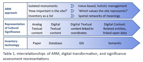
Cultural Significance Assessment of Archaeological Sites for Heritage Management: From Text of Spatial Networks of MeaningsHow Semantic Technologies and Spatial Networks Can Enhance Archaeological Resource ManagementRecommended by James Stuart Taylor based on reviews by Dominik Lukas and 1 anonymous reviewer
After a thorough review and consideration of the revised manuscript titled "Cultural Significance Assessment of Archaeological Sites for Heritage Management: From Text to Spatial Networks of Meanings" by Yael Alef and Yuval Shafriri [1], I am recommending the paper for publication. The authors have made significant strides in addressing the feedback from the initial review process, notably enhancing the manuscript's clarity, methodological detail, and overall contribution to the field of Archaeological Resource Management (ARM). On balance I think the paper competently navigates the shift from a traditional significance-focused assessment of isolated archaeological sites to a more holistic and interconnected approach, leveraging graph data models and spatial networks. This transition represents an advancement in the field, offering deeper insights into the sociocultural dynamics of archaeological sites. The case study of ancient synagogues in northern Israel, particularly the Huqoq Synagogue, serves as a compelling illustration of the potential of semantic technologies to enrich our understanding of cultural heritage. Significantly, the authors have responded to the call for a clearer methodological framework by providing a more detailed exposition of their use of knowledge graph visualization and semantic technologies. This response not only strengthens the paper's scientific rigor but also enhances its accessibility and applicability to a broader audience within the conservation and heritage management community. However, I do think it remains important to acknowledge areas where further work could enrich the paper's contribution. While the manuscript makes notable advancements in the technical and methodological domains, the exploration of the ethical and political implications of semantic technologies in ARM remains less developed. Recognizing the complex interplay of ethical and political considerations in archaeological assessments is crucial for the responsible advancement of the field. Thus, I suggest that future work could productively focus on these dimensions, offering a more comprehensive view of the implications of integrating semantic technologies into heritage management practices. I don't think that this omission is a reason to withold the paper for publication or seek further review. In fact I think it stands alone a paper quite well. Perhaps the authors might consider this as a complementary line of inquiry in their future work in the field. In conclusion then, I believe the revised manuscript represents a valuable addition to the literature, pushing boundaries of how we assess, understand, and manage archaeological resources. Its focus on semantic technologies and the creation of spatial networks of meanings marks a significant step forward in the field. I believe its publication will stimulate further research and discussion, particularly in the realms of ethical and political considerations, which remain ripe for exploration. Therefore, I'm happy to endorse the publication of this manuscript. Reference [1] Alef, Y and Shafriri, Y. (2024). Cultural Significance Assessment of Archaeological Sites for Heritage Management: From Text of Spatial Networks of Meanings. Zenodo, 8309992, ver. 5 peer-reviewed and recommended by Peer Community in Archaeology. https://doi.org/10.5281/zenodo.8309992 | Cultural Significance Assessment of Archaeological Sites for Heritage Management: From Text of Spatial Networks of Meanings | Yael Alef, Yuval Shafriri | <p>This study examines the shift towards a values-based approach for Archaeological Resource Management (ARM), emphasizing the integration of Context-Based Significance Assessment (CBSA) with semantic technologies into digital ARM inventories. We ... | | Computational archaeology, Conservation/Museum studies, Spatial analysis | James Stuart Taylor | 2023-09-01 22:24:15 | ||
10 Jan 2024
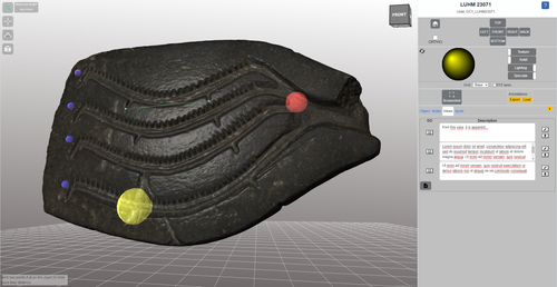
Linking Scars: Topology-based Scar Detection and Graph Modeling of Paleolithic Artifacts in 3DA valuable contribution to automated analysis of palaeolithic artefactsRecommended by Sebastian Hageneuer based on reviews by Lutz Schubert and 1 anonymous reviewer
In this paper (Linsel/Bullenkamp/Mara 2024), the authors propose an automatic system for scar-ridge-pattern detection on palaeolithic artefacts based on Morse Theory. Scare-Ridge pattern recognition is a process that is usually done manually while creating a drawing of the object itself. Automatic systems to detect scars or ridges exist, but only a small amount of them is utilizing 3D data. In addition to the scar-ridges detection, the authors also experiment in automatically detecting the operational sequence, the temporal relation between scars and ridges. As a result, they can export a traditional drawing as well as graph models displaying the relationships between the scars and ridges. After an introduction to the project and the practice of documenting palaeolithic artefacts, the authors explain their procedure in automatising the analysis of scars and ridges as well as their temporal relation to each other on these artefacts. To illustrate the process, an open dataset of lithic artefacts from the Grotta di Fumane, Italy, was used and 62 artefacts selected. To establish a Ground Truth, the artefacts were first annotated manually. The authors then continue to explain in detail each step of the automated process that follows and the results obtained. In the second part of the paper, the results are presented. First the results of the segmentation process shows that the average percentage of correctly labelled vertices is over 91%, which is a remarkable result. The graph modelling however shows some more difficulties, which the authors are aware of. To enhance the process, the authors rightfully aim to include datasets of experimental archaeology in the future. They also aim to develop a way of detecting the operational sequence automatically and precisely. This paper has great potential as it showcases exactly what Digital and Computational Archaeology is about: The development of new digital methods to enhance the analysis of archaeological data. While this procedure is still in development, the authors were able to present a valuable contribution to the automatization of analytical archaeology. By creating a step towards the machine-readability of this data, they also open up the way to further steps in machine learning within Archaeology. BibliographyLinsel, F., Bullenkamp, J. P., and Mara, H. (2024). Linking Scars: Topology-based Scar Detection and Graph Modeling of Paleolithic Artifacts in 3D, Zenodo, 8296269, ver. 3 peer-reviewed and recommended by Peer Community in Archaeology. https://doi.org/10.5281/zenodo.8296269 | Linking Scars: Topology-based Scar Detection and Graph Modeling of Paleolithic Artifacts in 3D | Florian Linsel, Jan Philipp Bullenkamp & Hubert Mara | <p>Motivated by the concept of combining the archaeological practice of creating lithic artifact drawings with the potential of 3D mesh data, our goal in this project is not only to analyze the shape at the artifact level, but also to enable a mor... | | Computational archaeology, Europe, Lithic technology, Upper Palaeolithic | Sebastian Hageneuer | 2023-09-01 23:03:59 | ||
08 Apr 2024
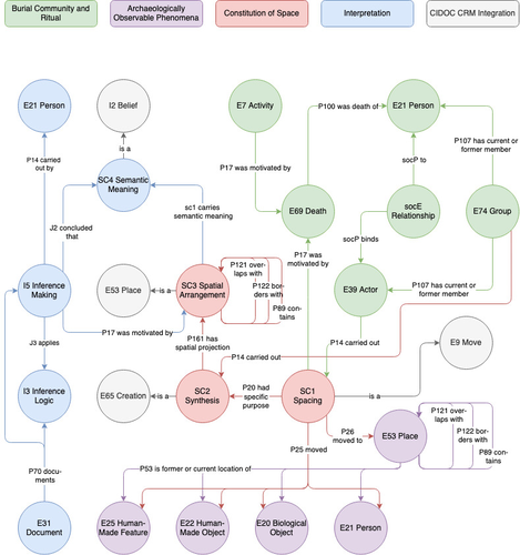
Spaces of funeral meaning. Modelling socio-spatial relations in burial contextsA new approach to a data ontology for the qualitative assessment of funerary spacesRecommended by Asuman Lätzer-Lasar based on reviews by 2 anonymous reviewers
The paper by Aline Deicke [1] is very readable, and it succeeds in presenting a still unnoticed topic in a well-structured way. It addresses the topic of “how to model social-spatial relations in antiquity”, as the title concisely implies, and makes important and interesting points about their interrelationship by drawing on latest theories of sociologists such as Martina Löw combined with digital tools, such as the CIDOC CRM-modeling. The author provides an introductory insight into the research history of funerary archaeology and addresses the problematic issue of not having investigated fully the placement of entities of the grave inventory. So far, the focus of the analysis has been on the composition of the assemblage and not on the positioning within this space-and time-limited context. However, the positioning of the various entities within the burial context also reveals information about the objects themselves, their value and function, as well as about the world view and intentions of the living and dead people involved in the burial. To obtain this form of qualitative data, the author suggests modeling knowledge networks using the CIDOC CRM. The method allows to integrate the spatial turn combined with aspects of the actor-network-theory. The theoretical backbone of the contribution is the fundamental scholarship of Martina Löw’s “Raumsoziologie” (sociology of space), especially two categories of action namely placing and spacing (SC1). The distinction between the two types of action enables an interpretative process that aims for the detection of meaningfulness behind the creation process (deposition process) and the establishment of spatial arrangement (find context). To illustrate with a case study, the author discusses elite burial sites from the Late Urnfield Period covering a region north of the Alps that stretches from the East of France to the entrance of the Carpathian Basin. With the integration of very basic spatial relations, such as “next to”, “above”, “under” and qualitative differentiations, for instance between iron and bronze knives, the author detects specific patterns of relations: bronze knives for food preparing (ritual activities at the burial site), iron knives associated with the body (personal accoutrement). The complexity of the knowledge engineering requires the gathering of several CIDOC CRM extensions, such as CRMgeo, CRMarchaeo, CRMba, CRMinf and finally CRMsoc, the author rightfully suggests. In the end, the author outlines a path that can be used to create this kind of data model as the basis for a graph database, which then enables a further analysis of relationships between the entities in a next step. Since this is only a preliminary outlook, no corrections or alterations are needed. The article is an important step in advancing digital archaeology for qualitative research. References [1] Deicke, A. (2024). Spaces of funeral meaning. Modelling socio-spatial relations in burial contexts. Zenodo, 8310170, ver. 4 peer-reviewed and recommended by Peer Community in Archaeology. https://doi.org/10.5281/zenodo.8310170 | Spaces of funeral meaning. Modelling socio-spatial relations in burial contexts | Aline Deicke | <p>Burials have long been one of the most important sources of archaeology, especially when studying past social practices and structure. Unlike archaeological finds from settlements, objects from graves can be assumed to have been placed there fo... | | Computational archaeology, Protohistory, Spatial analysis, Theoretical archaeology | Asuman Lätzer-Lasar | 2023-09-01 23:15:41 |


