Latest recommendations

| Id | Title | Authors | Abstract | Picture | Thematic fields▲ | Recommender | Reviewers | Submission date | |
|---|---|---|---|---|---|---|---|---|---|
02 Apr 2024
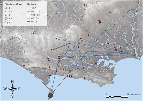
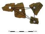
Similarity Network Fusion: Understanding Patterns and their Spatial Significance in Archaeological DatasetsA different approach to similarity networks in Archaeology - Similarity Network FusionRecommended by Joel Santos based on reviews by Matthew Peeples and 1 anonymous reviewerThis is a fascinating paper for anyone interested in network analysis or the chronology and cultures of the case study, namely the Late prehistoric burial sites in Dorset, for which the author’s approach allowed a new perspective over an already deeply studied area [1]. This paper's implementation of Similarity Network Fusion (SNF) is noteworthy. This method is typically utilized within genetic research but has yet to be employed in Archaeology. SNF has the potential to benefit Archaeology due to its unique capabilities and approach significantly. The author exhibits a deep and thorough understanding of previous investigations concerning material and similarity networks while emphasizing the innovative nature of this particular study. The SNF approach intends to improve a lack of the most used (in Archaeology) similarity coefficient, the Brainerd-Robinson, in certain situations, mainly in heterogenous and noisy datasets containing a small number of samples but a large number of measurements, scale differences, and collection biases, among other things. The SNF technique, demonstrated in the case study, effectively incorporates various similarity networks derived from different datatypes into one network. As shown during the Dorset case study, the SNF application has a great application in archaeology, even in already available data, allowing us to go further and bring new visions to the existing interpretations. As stated by the author, SNF shows its potential for other applications and fields in archaeology coping with similar datasets, such as archaeobotany or archaeozoology, and seems to complement different multivariate statistical approaches, such as correspondence or cluster analysis. This paper has been subject to two excellent revisions, which the author mostly accepted. One of the revisions was more technical, improving the article in the metadata part, data availability and clarification, etc. Although the second revision was more conceptual and gave some excellent technical inputs, it focused more on complementary aspects that will allow the paper to reach a wider audience. I vividly recommend its publication. References [1] Geitlinger, T. (2024). Similarity Network Fusion: Understanding Patterns and their Spatial Significance in Archaeological Datasets. Zenodo, 7998239, ver. 3 peer-reviewed and recommended by Peer Community in Archaeology. https://doi.org/10.5281/zenodo.7998239
| Similarity Network Fusion: Understanding Patterns and their Spatial Significance in Archaeological Datasets | Timo Geitlinger | <p>Since its earliest application in the 1970s, network analysis has become increasingly popular in both theoretical and GIS-based archaeology. Yet, applications of material networks remained relatively restricted. This paper describes a specific ... | | Computational archaeology, Protohistory | Joel Santos | 2023-06-02 16:51:19 | ||
08 Apr 2024
Spaces of funeral meaning. Modelling socio-spatial relations in burial contextsA new approach to a data ontology for the qualitative assessment of funerary spacesRecommended by Asuman Lätzer-Lasar based on reviews by 2 anonymous reviewers based on reviews by 2 anonymous reviewers
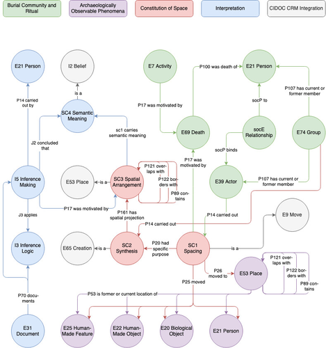
The paper by Aline Deicke [1] is very readable, and it succeeds in presenting a still unnoticed topic in a well-structured way. It addresses the topic of “how to model social-spatial relations in antiquity”, as the title concisely implies, and makes important and interesting points about their interrelationship by drawing on latest theories of sociologists such as Martina Löw combined with digital tools, such as the CIDOC CRM-modeling. The author provides an introductory insight into the research history of funerary archaeology and addresses the problematic issue of not having investigated fully the placement of entities of the grave inventory. So far, the focus of the analysis has been on the composition of the assemblage and not on the positioning within this space-and time-limited context. However, the positioning of the various entities within the burial context also reveals information about the objects themselves, their value and function, as well as about the world view and intentions of the living and dead people involved in the burial. To obtain this form of qualitative data, the author suggests modeling knowledge networks using the CIDOC CRM. The method allows to integrate the spatial turn combined with aspects of the actor-network-theory. The theoretical backbone of the contribution is the fundamental scholarship of Martina Löw’s “Raumsoziologie” (sociology of space), especially two categories of action namely placing and spacing (SC1). The distinction between the two types of action enables an interpretative process that aims for the detection of meaningfulness behind the creation process (deposition process) and the establishment of spatial arrangement (find context). To illustrate with a case study, the author discusses elite burial sites from the Late Urnfield Period covering a region north of the Alps that stretches from the East of France to the entrance of the Carpathian Basin. With the integration of very basic spatial relations, such as “next to”, “above”, “under” and qualitative differentiations, for instance between iron and bronze knives, the author detects specific patterns of relations: bronze knives for food preparing (ritual activities at the burial site), iron knives associated with the body (personal accoutrement). The complexity of the knowledge engineering requires the gathering of several CIDOC CRM extensions, such as CRMgeo, CRMarchaeo, CRMba, CRMinf and finally CRMsoc, the author rightfully suggests. In the end, the author outlines a path that can be used to create this kind of data model as the basis for a graph database, which then enables a further analysis of relationships between the entities in a next step. Since this is only a preliminary outlook, no corrections or alterations are needed. The article is an important step in advancing digital archaeology for qualitative research. References [1] Deicke, A. (2024). Spaces of funeral meaning. Modelling socio-spatial relations in burial contexts. Zenodo, 8310170, ver. 4 peer-reviewed and recommended by Peer Community in Archaeology. https://doi.org/10.5281/zenodo.8310170 | Spaces of funeral meaning. Modelling socio-spatial relations in burial contexts | Aline Deicke | <p>Burials have long been one of the most important sources of archaeology, especially when studying past social practices and structure. Unlike archaeological finds from settlements, objects from graves can be assumed to have been placed there fo... | | Computational archaeology, Protohistory, Spatial analysis, Theoretical archaeology | Asuman Lätzer-Lasar | 2023-09-01 23:15:41 | ||
02 Jan 2024
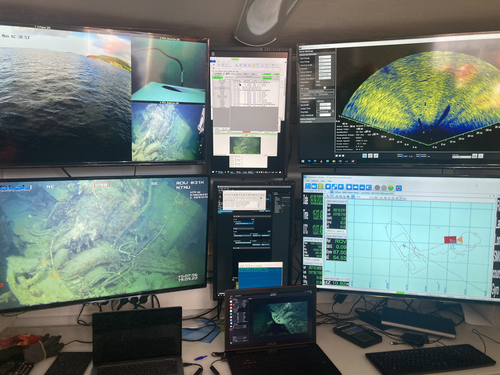
Advancing data quality of marine archaeological documentation using underwater robotics: from simulation environments to real-world scenariosBeyond Deep Blue: Underwater robotics, simulations and archaeologyRecommended by Daniel Carvalho based on reviews by Marco Moderato and 1 anonymous reviewerDiamanti et al. (2024) is a significant contribution to the field of underwater robotics and their use in archaeology, with an innovative approach to some major problems in the deployment of said technologies. It identifies issues when it comes to approaching Underwater Cultural Heritage (UCH) sites and does so through an interest in the combination of data, maneuverability, and the interpretation provided by the instruments that archaeologists operate. The article's motives are clear: it is not enough to find the means to reach these sites, but rather is fundamental to take a step forward in methodology and how we can safeguard certain aspects of data recovery with robust mission planning. To this end, the article does not fail to highlight previous contributions, in an intertwined web of references that demonstrate the marked evolution of the use of Unmanned Underwater Vehicles (UUVs), Remote Operated Vehicles (ROVs), Autonomous Underwater Vehicles (AUVs) and Autonomous Surface Vehicles (ASVs), which are growing exponentially in use (see Kapetanović et al. 2020). It should be emphasized that the notion of ‘aquatic environment’ used here is quite broad and is not limited to oceanic or maritime environments, which allows for a larger perspective on distinct technologies that proliferate in underwater archaeology. There is also a relevant discussion on the typologies of sensors and how these autonomous vehicles obtain their data, where are debated Inertial Measurement Units (IMU) and LiDAR systems. Thus, the authors of this article propose the creation of a model that acquires data through simulations, which allows for a better understanding of what a real mission presupposes in the field. Their tripartite method - pre-mission planning; mission plan and post-mission plan - offers a performing algorithm that simplifies and provides reliability to all the parts of the intervention. The use of real cases to create simulation models allows for a substantial approximation to common practice in underwater environments. And yet, the article is at its most innovative status when it combines all the elements it sets out to explore. It could simply focus on the methodological or planning component, on obtaining data, or on theoretical problems. But it goes further, which makes this approach more complete and of interest to the archaeological community. By not taking any part as isolated, the problems and possible solutions arising from the course of the mission are carried over from one parameter to another, where details are worked upon and efficiency goals are set. One of the most significant cases is the tuning of ocean optics in aquatic environments according to the idiosyncracies of real cases (Diamanti et al. 2024: 8), a complex endeavor but absolutely necessary in order to increase the informative potential of the simulation. The exploration of various data capture models is also welcome, for the purposes of comparison and adaptation on a case-by-case basis. The brief theoretical reflection offered at the end of the article dwells in all these points and problematizes the difference between terrestrial and aquatic archaeology. In fact, the distinction does not only exist in the technical component, as although it draws in theoretical elements from archaeology that is carried out on land (see Krieger 2012 for this matter), the problems and interpretations are shaped by different factors and therefore become unique (Diamanti et al 2024: 15). The future, according to the authors, lies in increasing the autonomy of these vehicles so that the human element does not have to make decisions in a systematic way. It is in that note, and in order for that path to become closer to reality, that we strongly recommend this article for publication, in conjunction with the comments of the reviewers. We hope that its integrated approach, which brings together methods, theories and reflections, can become a broader modus operandi within the field of underwater robotics applied to archaeology. References: Diamanti, E., Yip, M., Stahl, A. and Ødegård, Ø. (2024). Advancing data quality of marine archaeological documentation using underwater robotics: from simulation environments to real-world scenarios, Zenodo, 8305098, ver. 4 peer-reviewed and recommended by Peer Community in Archaeology. https://doi.org/10.5281/zenodo.8305098 Kapetanović, N., Vasilijević, A., Nađ, Đ., Zubčić, K., and Mišković, N. (2020). Marine Robots Mapping the Present and the Past: Unraveling the Secrets of the Deep. Remote Sensing, 12(23), 3902. MDPI AG. http://dx.doi.org/10.3390/rs12233902 Krieger, W. H. (2012). Theory, Locality, and Methodology in Archaeology: Just Add Water? HOPOS: The Journal of the International Society for the History of Philosophy of Science, 2(2), 243–257. https://doi.org/10.1086/666956
| Advancing data quality of marine archaeological documentation using underwater robotics: from simulation environments to real-world scenarios | Diamanti, Eleni; Yip, Mauhing; Stahl, Annette; Ødegård, Øyvind | <p>This paper presents a novel method for visual-based 3D mapping of underwater cultural heritage sites through marine robotic operations. The proposed methodology addresses the three main stages of an underwater robotic mission, specifically the ... | | Computational archaeology, Remote sensing | Daniel Carvalho | 2023-08-31 16:03:10 | ||
20 Feb 2024
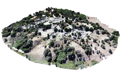
Understanding Archaeological Site Topography: 3D Archaeology of ArchaeologyRewriting Archaeological Narratives: Archaeology of Archaeology through 3D Site Topography RecordingRecommended by Devi Taelman based on reviews by Geert Verhoeven, Jesús García-Sánchez and Catherine Scott
Even though applications of 3D recording have existed in archaeology for a long time, it is only since the early 2000s that this field of research has become mainstream thanks to technological advances, and the availability of low-cost sensors and image-based modelling software. This has led to significant changes in the way archaeological sites are documented. This paper entitled "Understanding Archaeological Site Topography: 3D Archaeology of Archaeology" by Jitte Waagen & Gert Jan van Wijngaarden (2024) presents an overview of the current developments in the application possibilities of 3D site topography recording in archaeology. The paper is the result of the round table discussion "Understanding Archaeological Site Topography: 3D Archaeology of Archaeology" at the CAA conference on 5 April 2023 in Amsterdam, with contributions from Radu Brunchi, Nicola Lercari, Joep Orbons, Davide Tanasi, Alicia Walsh, Pawel Wolf and Teagan Zoldoske. The paper starts with a discussion of the Amsterdam Troy Project (ATP). In the frame of the ATP, the rich history of archaeological activity (over 150 years of fieldwork) at Troy is being studied to explore how previous archaeological research has helped to shape the current topography of the site and how these earlier research activities, embedded in their contemporary theoretical frameworks, have determined our understanding of the site (see Murray and M. Spriggs 2017, Carver 2011 for the influence of theory on archaeological fieldwork and archaeology as a discipline), the so-called 'Archaeology of Archaeology' approach. In addition to studying previous research records and re-excavating old excavation trenches, a central element of the project is the 3D recording of the past and present topography of the site in order to reconstruct the archaeological research activities at the site and their impact on the archaeological landscape. The paper focuses on current trends in 3D recording of archaeological site topography and discusses three main areas where 3D recording of archaeological site topography can contribute to the "Archaeology of Archaeology" approach: (1) monitoring the topography of sites for preservation, conservation, research and dissemination purposes; (2) reconstructing, reevaluating and reinterpreting past archaeological research efforts; and (3) archiving in a 4D (GIS) environment. This is done using the example of the Amsterdam Troy project and comparing it with other projects using similar methods and approaches. Using these case studies, the authors effectively discuss the impact of these technologies on the understanding of the topography of archaeological sites and how 3D recording can enhance archaeological research methodologies and interpretations, for example, by not using such 3D approaches as a stand-alone product but integrating them with available information from previous research activities. They also recognise the limitations and challenges involved, such as the need for customised data acquisition strategies and the lack of ready-made software solutions for developing comprehensive data management strategies. One topic that could have been covered in more detail is how 3D site topography recording (and 3D recording in general) is affected by current theoretical developments in archaeology. Like any other archaeological fieldwork or data collection approach, it is a child of its time. Decisions such as what to record, how to record, what to store, how to store, what to visualise, and how to visualise influence our understanding of archaeological sites (Ward 2022). This minor critical reflection aside, the paper makes a timely and significant contribution to archaeology by addressing current trends and the limitations of the increasingly widespread use of 3D site topography recording technologies. References Carver, G. (2011). Reflections on the archaeology of archaeological excavation, Archaeological Dialogues 18(1), pp. 18–26. https://doi.org/10.1017/S1380203811000067 Murray, T. and Spriggs, M. (2017). The historiography of archaeology: exploring theory, contingency and rationality, World Archaeology 49(2), pp. 151–157. https://doi.org/10.1080/00438243.2017.1334583 Ward, C. (2022). Excavating the Archive / Archiving the Excavation: Archival Processes and Contexts in Archaeology, Advances in Archaeological Practice 10(2), pp. 160–176. https://doi.org/10.1017/aap.2022.1 Waagen, J. and van Wijngaarden, G.J. (2024). Understanding Archaeological Site Topography: 3D Archaeology of Archaeology, Zenodo, 10061343, ver. 3 peer-reviewed and recommonded by Peer Community in Archaeology. https://doi.org/10.5281/zenodo.10061343 | Understanding Archaeological Site Topography: 3D Archaeology of Archaeology | Waagen, Jitte & Wijngaarden, Gert Jan van | <p>The current ubiquitous use of 3D recording technologies in archaeological fieldwork, for a large part due to the application of budget-friendly (drone) sensors and the availability of many low-cost image-based 3D modelling software packages, ha... | | Computational archaeology, Remote sensing | Devi Taelman | 2023-10-17 23:03:47 | ||
29 Jan 2024
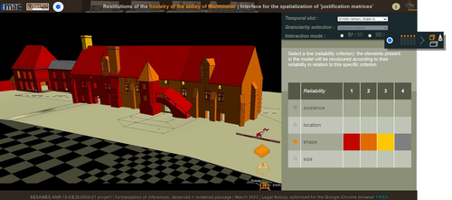
Visual encoding of a 3D virtual reconstruction's scientific justification: feedback from a proof-of-concept research3D Models, Knowledge and Visualization: a prototype for 3D virtual models according to plausible criteriaRecommended by Daniel Carvalho based on reviews by Robert Bischoff and Louise TharandtThe construction of 3D realities is deeply embedded in archaeological practices. From sites to artifacts, archaeology has dedicated itself to creating digital copies for the most varied purposes. The paper “Visual encoding of a 3D virtual reconstruction's 3 scientific justification: feedback from a proof-of-concept research” (Jean-Yves et al 2024) represents an advance, in the sense that it does not just deal with a three-dimensional theory for archaeological practice, but rather offers proposals regarding the epistemic component, how it is possible to represent knowledge through the workflow of 3D virtual reconstructions themselves. The authors aim to unite three main axes - knowledge modeling, visual encoding and 3D content reuse - (Jean-Yves et al 2024: 2), which, for all intents and purposes, form the basis of this article. With regard to the first aspect, this work questions how it is possible to transmit the knowledge we want to a 3D model and how we can optimize this epistemic component. A methodology based on plausibility criteria is offered, which, for the archaeological field, offers relevant space for reflection. Given our inability to fully understand the object or site that is the subject of the 3D representation, whether in space or time, building a method based on probabilistic categories is probably one of the most realistic approaches to the realities of the past. Thus, establishing a plausibility criterion allows the user to question the knowledge that is transmitted through the representation, and can corroborate or refute it in future situations. This is because the role of reusing these models is of great interest to the authors, a perfectly justifiable sentiment, as it encourages a critical view of scientific practices. Visual encoding is, in terms of its conjunction with knowledge practices, a key element. The notion of simplicity under Maeda's (2006) design principles not only represents a way of thinking that favors operability, but also a user-friendly design in the prototype that the authors have created. This is also visible when it comes to the reuse of parts of the models, in a chronological logic: adapting the models based on architectural elements that can be removed or molded is a testament to intelligent design, whereby instead of redoing models in their entirety, they are partially used for other purposes. All these factors come together in the final prototype, a web application that combines relational databases (RDBMS) with a data mapper (MassiveJS), using the PHP programming language. The example used is the Marmoutier Abbey hostelry, a centuries-old building which, according to the sources presented, has evolved architecturally over several centuries ((Jean-Yves et al 2024: 8). These states of the building are represented visually through architectural elements based on their existence, location, shape and size, always in terms of what is presented as being plausible. This allows not only the creation of a matrix in which various categories are related to various architectural elements, but also a visual aid, through a chromatic spectrum, of the plausibility that the authors are aiming for. In short, this is an article that seeks to rethink the degree of knowledge we can obtain through 3D visualizations and that does not take models as static, but rather realities that must be explored, recycled and reinterpreted in the light of different data, users and future research. For this reason, it is a work of great relevance to theoretical advances in 3D modeling adapted to archaeology.
References Blaise, J.-Y., Dudek, I., Bergerot, L. and Gaël, S. (2024). Visual encoding of a 3D virtual reconstruction's scientific justification: feedback from a proof-of-concept research, Zenodo, 7983163, ver. 3 peer-reviewed and recommended by Peer Community in Archaeology. https://doi.org/10.5281/zenodo.10496540 John Maeda. (2006). The Laws of Simplicity. MIT Press, Cambridge, MA, USA. | Visual encoding of a 3D virtual reconstruction's scientific justification: feedback from a proof-of-concept research | J.Y Blaise, I.Dudek, L.Bergerot, G.Simon | <p> 3D virtual reconstructions have become over the last decades a classical mean to communicate about analysts’ visions concerning past stages of development of an edifice or a site. However, they still today remain quite often a one-s... | | Computational archaeology, Spatial analysis | Daniel Carvalho | 2023-05-30 00:43:03 | ||
20 Mar 2024
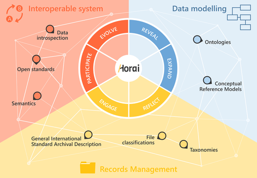
HORAI: An integrated management model for historical informationA novel management model for historical informationRecommended by Isto Huvila based on reviews by Leandro Sánchez Zufiaurre and 1 anonymous reviewerThe paper “HORAI: An integrated management model for historical information” presents a novel model for managing historical information. The study draws from an extensive indepth work in historical information management and a multi-disciplinary corpus of research ranging from heritage infrastructure research and practice to information studies and archival management literature. The paper ties into several key debates and discussions in the field showing awareness of the state-of-the-art of data management practice and theory. The authors argue for a new semantic data model HORAI and link it to a four-phase data management lifecycle model. The conceptual work is discussed in relation to three existing information systems partly predating and partly developed from the outset of the HORAI-model. While the paper shows appreciable understanding of the practical and theoretical state-of-the-art and the model has a lot of potential, in its current form it is still somewhat rough on the edges. Many of the both practical and theoretical threads introduced in the text warrant also more indepth consideration and it will be interesting to follow how the work will proceed in the future. For example, the comparison of the HORAI model and the ISAD(G): General International Standard Archival Description standard in the figure 1 is interesting but would require more elaboration. A slightly more thorough copyediting of the text would have also been helpful to make it more approachable. As a whole, in spite of the critique, I find both the paper and the model as valuable contributions to the literature and the practice of managing historical information. The paper reports thorough work, provides a lot of food for thought and several interesting lines of inquiry in the future. ReferencesDel Fresno Bernal, P., Medina Gordo, S. and Travé Allepuz, E. (2024). HORAI: An integrated management model for historical information. CAA 2023, Amsterdam, Netherlands. https://doi.org/10.5281/zenodo.8185510 | HORAI: An integrated management model for historical information | Pablo del Fresno Bernal, Sonia Medina Gordo and Esther Travé Allepuz | <p>The archiving process goes beyond mere data storage, requiring a theoretical, methodological, and conceptual commitment to the sources of information. We present Horai as a semantic-based integration model designed to facilitate the development... | | Computational archaeology, Spatial analysis | Isto Huvila | 2023-07-26 09:33:58 | ||
05 Jun 2023
SEAHORS: Spatial Exploration of ArcHaeological Objects in R ShinyAnalyzing piece-plotted artifacts just got simpler: A good solution to the wrong problem?Recommended by Reuven Yeshurun based on reviews by Frédéric Santos, Jacqueline Meier and Maayan LevPaleolithic archaeologists habitually measure 3-coordinate data for artifacts in their excavations. This was first done manually, and in the last three decades it is usually performed by a total station and associated hardware. While the field recording procedure is quite straightforward, visualizing and analyzing the data are not, often requiring specialized proprietary software or coding expertise. Here, Royer and colleagues (2023) present the SEAHORS application, an elegant solution for the post-excavation analysis of artifact coordinate data that seems to be instantly useful for numerous archaeologists. SEAHORS allows one to import and organize field data (Cartesian coordinates and point description), which often comes in a variety of formats, and to create various density and distribution plots. It is specifically adapted to the needs of archaeologists, is free and accessible, and much simpler to use than many commercial programs. The authors further demonstrate the use of the application in the post-excavation analysis of the Cassenade Paleolithic site (see also Discamps et al., 2019). While in no way detracting from my appreciation of Royer et al.’s (2023) work, I would like to play the devil’s advocate by asking whether, in the majority of cases, field recording of artifacts in three coordinates is warranted. Royer et al. (2023) regard piece plotting as “…indispensable to propose reliable spatial planimetrical and stratigraphical interpretations” but this assertion does not hold in all (or most) cases, where careful stratigraphic excavation employing thin volumetric units would do just as well. Moreover, piece-plotting has some serious drawbacks. The recording often slows excavations considerably, beyond what is needed for carefully exposing and documenting the artifacts in their contexts, resulting in smaller horizontal and vertical exposures (e.g., Gilead, 2002). This typically hinders a fuller stratigraphic and contextual understanding of the excavated levels and features. Even worse, the method almost always creates a biased sample of “coordinated artifacts”, in which the most important items for understanding spatial patterns and site-formation processes – the small ones – are underrepresented. Some projects run the danger of treating the coordinated artifacts as bearing more significance than the sieve-recovered items, preferentially studying the former with no real justification. Finally, the coordinated items often go unassigned to a volumetric unit, effectively disconnecting them from other types of data found in the same depositional contexts. The advantages of piece-plotting may, in some cases, offset the disadvantages. But what I find missing in the general discourse (certainly not in the recommended preprint) is the “theory” behind the seemingly technical act of 3-coordinate recording (Yeshurun, 2022). Being in effect a form of sampling, this practice needs a rethink about where and how to be applied; what depositional contexts justify it, and what the goals are. These questions should determine if all “visible” artifacts are plotted, or just an explicitly defined sample of them (e.g., elongated items above a certain length threshold, which should be more reliable for fabric analysis), or whether the circumstances do not actually justify it. In the latter case, researchers sometimes opt for using “virtual coordinates” within in each spatial unit (typically 0.5x0.5 m), essentially replicating the data that is generated by “real” coordinates and integrating the sieve-recovered items as well. In either case, Royer et al.’s (2023) solution for plotting and visualizing labeled points within intra-site space would indeed be an important addition to the archaeologists’ tool kits.
References cited Discamps, E., Bachellerie, F., Baillet, M. and Sitzia, L. (2019). The use of spatial taphonomy for interpreting Pleistocene palimpsests: an interdisciplinary approach to the Châtelperronian and carnivore occupations at Cassenade (Dordogne, France). Paleoanthropology 2019, 362–388. https://doi.org/10.4207/PA.2019.ART136 Gilead, I. (2002). Too many notes? Virtual recording of artifacts provenance. In: Niccolucci, F. (Ed.). Virtual Archaeology: Proceedings of the VAST Euroconference, Arezzo 24–25 November 2000. BAR International Series 1075, Archaeopress, Oxford, pp. 41–44. Royer, A., Discamps, E., Plutniak, S. and Thomas, M. (2023). SEAHORS: Spatial Exploration of ArcHaeological Objects in R Shiny Zenodo, 7957154, ver. 2 peer-reviewed and recommended by Peer Community in Archaeology. https://doi.org/10.5281/zenodo.7929462 Yeshurun, R. (2022). Intra-site analysis of repeatedly occupied camps: Sacrificing “resolution” to get the story. In: Clark A.E., Gingerich J.A.M. (Eds.). Intrasite Spatial Analysis of Mobile and Semisedentary Peoples: Analytical Approaches to Reconstructing Occupation History. University of Utah Press, pp. 27–35.
| SEAHORS: Spatial Exploration of ArcHaeological Objects in R Shiny | ROYER, Aurélien, DISCAMPS, Emmanuel, PLUTNIAK, Sébastien, THOMAS, Marc | <p style="text-align: justify;">This paper presents SEAHORS, an R shiny application available as an R package, dedicated to the intra-site spatial analysis of piece-plotted archaeological remains. This open-source script generates 2D and 3D scatte... | | Computational archaeology, Spatial analysis, Theoretical archaeology | Reuven Yeshurun | 2023-02-24 16:01:44 | ||
24 Jun 2021
The strength of parthood ties. Modelling spatial units and fragmented objects with the TSAR method – Topological Study of Archaeological RefittingA practical computational approach to stratigraphic analysis using conjoinable material culture.Recommended by Hector A. Orengo based on reviews by Robert Bischoff, Matthew Peeples and 1 anonymous reviewerThe paper by Plutniak [1] presents a new method that uses refitting to help interpret stratigraphy using the topological distribution of conjoinable material culture. This new method opens up new avenues to the archaeological use of network analysis but also to assess the integrity of interpreted excavation layers. Beyond its evident applicability to standard excavation practice, the paper presents a series of characteristics that exemplify archaeological publication best practices and, as someone more versed in computational than in refitting studies I would like to comment upon. It was no easy task to find adequate reviewers for this paper as it combines techniques and expertise that are not commonly found together in individual researchers. However, Plutniak, with help from three reviewers, particularly M. Peeples, a leading figure in archaeological applications of network science, makes a considerable effort to be accessible to non-specialist archaeologists. The core Topological Study of Archaeological Refitting (TSAR) method is freely accessible as the R package archeofrag, which is available at the Comprehensive R Archive Network (https://CRAN.R-project.org/package=archeofrag) that can be applied without the need to understand all its mathematical, graph theory and coding aspects. Beside these, an online interface including test data has been provided (https://analytics.huma-num.fr/Sebastien.Plutniak/archeofrag/), which aims to ease access to the method to those archaeologists inexperienced with R. Finally, supplementary material showing how to use the package and evaluating its potential through excellent examples is provided as both pdf and Rmw (Sweave) files. This is an important companion for the paper as it allows a better understanding of the methods presented in the paper and its practical application. The author shows particular care in testing the potential and capabilities of the method. For example, a function is provided “frag.observer.failure” to test the robustness of the edge count method against the TSAR method, which is able to prove that TSAR can deal well with incomplete information. As a further step in this direction both simulated and real field-acquired data are used to test the method which further proves that archeofrag is not only able to quantitatively assess the mixture of excavated layers but to propose meaningful alternatives, which no doubt will add an increased methodological consistency and thoroughness to previous quantitative approaches to material refitting work, even when dealing with very complex stratigraphies. All in all, this paper makes an important contribution to core archaeological practice through the use of innovative, reproducible and accessible computational methods. I fully endorse it for the conscious and solid methods it presents but also for its adherence to open publication practices. I hope that it can become of standard use in the reconstruction of excavated stratigraphical layers through conjoinable material culture.
[1] Plutniak, S. 2021. The Strength of Parthood Ties. Modelling Spatial Units and Fragmented Objects with the TSAR Method – Topological Study of Archaeological Refitting. OSF Preprints, q2e69, ver. 3 Peer-reviewed and recommended by PCI Archaeology. https://doi.org/10.31219/osf.io/q2e69. | The strength of parthood ties. Modelling spatial units and fragmented objects with the TSAR method – Topological Study of Archaeological Refitting | Sébastien Plutniak | <p>Refitting and conjoinable pieces have long been used in archaeology to assess the consistency of discrete spatial units, such as layers, and to evaluate disturbance and post-depositional processes. The majority of current methods, despite their... | | Computational archaeology, Taphonomy | Hector A. Orengo | 2021-01-14 18:31:01 | ||
21 Mar 2023
Archaeology, Typology and Machine EpistemologyAutomation and Novelty –Archaeocomputational Typo-Praxis in the Wake of the Third Science RevolutionRecommended by Shumon Tobias Hussain, Felix Riede and Sébastien Plutniak based on reviews by Rachel Crellin and 1 anonymous reviewer
“Archaeology, Typology and Machine Epistemology” submitted by G. Lucas (1) offers a refreshing and welcome reflection on the role of computer-based practice, type-thinking and approaches to typology in the age of big data and the widely proclaimed ‘Third Science Revolution’ (2–4). At the annual meeting of the EAA in Maastricht in 2017, a special thematic block was dedicated to issues and opportunities linked to the Third Science Revolution in archaeology “because of [its] profound and wide ranging impact on practice and theory in archaeology for the years to come” (5). Even though the Third Science Revolution, as influentially outlined by Kristiansen in 2014 (2), has occasionally also been met with skepticism and critique as to its often implicit scientism and epistemological naivety (6–8), archaeology as a whole seems largely euphoric as to the promises of the advancing ‘revolution’. As Lucas perceptively points out, some even regard it as the long-awaited opportunity to finally fulfil the ambitions and goals of Anglophone processualism. The irony here, as Lucas rightly notes, is that early processualists initially foregrounded issues of theory and scientific epistemology, while much work conducted under the banner of the Third Science Revolution, especially within its computational branches, does not. Big data advocates have echoed Anderson’s much-cited “end of theory” (9) or at least emphatically called for an ‘empirization’ and ‘computationalization’ of theory, often under the banner of ‘data-driven archaeology’ (10), yet typically without much specification of what this is supposed to mean for archaeological theory and reflexivity. The latter is indeed often openly opposed by archaeological Third Science Revolution enthusiasts, arguably because it is viewed as part of the supposedly misguided ‘post-modernist’ project. Lucas makes an original meta-archaeological contribution here and attempts to center the epistemological, ontological and praxeological dimensions of what is actually – in situated archaeological praxis and knowledge-production – put at stake by the mobilization of computers, algorithms and artificial intelligence (AI), including its many but presently under-reflected implications for ordering practices such as typologization. Importantly, his perspective thereby explicitly and deliberately breaks with the ‘normative project’ in traditional philosophy of science, which sought to nail down a universal, prescriptive way of doing science and securing scientific knowledge. He instead focuses on the practical dimensions and consequences of computer-reliant archaeologies, what actually happens on the ground as researchers try to grapple with the digital and the artefactual and try to negotiate new insights and knowledge, including all of the involved messiness – thereby taking up the powerful impetus of the broader practice turn in interdisciplinary science studies and STS (Science and Technology Studies (11)) (12–14), which have recently also re-oriented archaeological self-observation, metatheory and epistemology (15). This perspective on the dawning big data age in archaeology and incurred changes in the status, nature and aims of type-thinking produces a number of important insights, which Lucas fruitfully discusses in relation to promises of ‘automation’ and ‘novelty’ as these feature centrally in the rhetorics and politics of the Third Science Revolution. With regard to automation, Lucas makes the important point that machine or computer work as championed by big data proponents cannot adequately be qualified or understood if we approach the issue from a purely time-saving perspective. The question we have to ask instead is what work do machines actually do and how do they change the dynamics of archaeological knowledge production in the process? In this optic, automation and acceleration achieved through computation appear to make most sense in the realm of the uncontroversial, in terms of “reproducing an accepted way of doing things” as Lucas says, and this is precisely what can be observed in archaeological practice as well. The ramifications of this at first sight innocent realization are far-reaching, however. If we accept the noncontroversial claim that automation partially bypasses the need for specialists through the reproduction of already “pre-determined outputs”, automated typologization would primarily be useful in dealing with and synthesizing larger amounts of information by sorting artefacts into already accepted types rather than create novel types or typologies. If we identity the big data promise at least in part with automation, even the detection of novel patterns in any archaeological dataset used to construct new types cannot escape the fact that this novelty is always already prefigured in the data structure devised. The success of ‘supervised learning’ in AI-based approaches illustrates this. Automation thus simply shifts the epistemological burden back to data selection and preparation but this is rarely realized, precisely because of the tacit requirement of broad non-contentiousness. Minimally, therefore, big data approaches ironically curtail their potential for novelty by adhering to conventional data treatment and input formats, rarely problematizing the issue of data construction and the contested status of (observational) data themselves. By contrast, they seek to shield themselves against such attempts and tend to retain a tacit universalism as to the nature of archaeological data. Only in this way is it possible to claim that such data have the capacity to “speak for themselves”. To use a concept borrowed from complexity theory, archaeological automation-based type-construction that relies on supposedly basal, incontrovertible data inputs can only ever hope to achieve ‘weak emergence’ (16) – ‘strong emergence’ and therefore true, radical novelty require substantial re-thinking of archaeological data and how to construct them. This is not merely a technical question as sometimes argued by computational archaeologies – for example with reference to specifically developed, automated object tracing procedures – as even such procedures cannot escape the fundamental question of typology: which kind of observations to draw on in order to explore what aspects of artefactual variability (and why). The focus on readily measurable features – classically dimensions of artefactual form – principally evades the key problem of typology and ironically also reduces the complexity of artefactual realities these approaches assert to take seriously. The rise of computational approaches to typology therefore reintroduces the problem of universalism and, as it currently stands, reduces the complexity of observational data potentially relevant for type-construction in order to enable to exploration of the complexity of pattern. It has often been noted that this larger configuration promotes ‘data fetishism’ and because of this alienates practitioners from the archaeological record itself – to speak with Marxist theory that Lucas briefly touches upon. We will briefly return to the notion of ‘distance’ below because it can be described as a symptomatic research-logical trope (and even a goal) in this context of inquiry. In total, then, the aspiration for novelty is ultimately difficult to uphold if computational archaeologies refuse to engage in fundamental epistemological and reflexive self-engagement. As Lucas poignantly observes, the most promising locus for novelty is currently probably not to be found in the capacity of the machines or algorithms themselves, but in the modes of collaboration that become possible with archaeological practitioners and specialists (and possibly diverse other groups of knowledge stakeholders). In other words, computers, supercomputers and AI technologies do not revolutionize our knowledge because of their superior computational and pattern-detection capacities – or because of some mysterious ‘superintelligence’ – but because of the specific ‘division of labour’ they afford and the cognitive challenge(s) they pose. Working with computers and AI also often requires to ask new questions or at least to adapt the questions we ask. This can already be seen on the ground, when we pay attention to how machine epistemologies are effectively harnessed in archaeological practice (and is somewhat ironic given that the promise of computational archaeology is often identified with its potential to finally resolve "long-standing (old) questions"). The Third Science Revolution likely prompts a consequential transformation in the structural and material conditions of the kinds of ‘distributed’ processes of knowledge production that STS have documented as characteristic for scientific discoveries and knowledge negotiations more generally (14, 17, 18). This ongoing transformation is thus expected not only to promote new specializations with regard to the utilization of the respective computing infrastructures emerging within big data ecologies but equally to provoke increasing demand for new ways of conceptualizing observations and to reformulate the theoretical needs and goals of typology in archaeology. The rediscovery of reflexivity as an epistemic virtue within big data debates would be an important step into this direction, as it would support the shared goal of achieving true epistemic novelty, which, as Lucas points out, is usually not more than an elusive self-declaration. Big data infrastructures require novel modes of human-machine synergy, which simply cannot be developed or cultivated in an atheoretical and/or epistemological disinterested space. Lucas’ exploration ultimately prompts us to ask big questions (again), and this is why this is an important contribution. The elephant in the room, of course, is the overly strong notion of objectivity on which much computational archaeology is arguably premised – linked to the vow to eventually construct ‘objective typologies’. This proclivity, however, re-tables all the problematic debates of the 1960s and – to speak with the powerful root metaphor of the machine fueling much of causal-mechanistic science (19, 20) – is bound to what A. Wylie (21) and others have called the ‘view from nowhere’. Objectivity, in this latter view, is defined by the absence of positionality and subjectivity – chiefly human subjectivity – and the promise of the machine, and by extension of computational archaeology, is to purify and thus to enhance processes of knowledge production by minimizing human interference as much as possible. The distancing of the human from actual processes of data processing and inference is viewed as positive and sometimes even as an explicit goal of scientific development. Interestingly, alienation from the archaeological record is framed as an epistemic virtue here, not as a burden, because close connection with (or even worse, immersion in) the intricacies of artefacts and archaeological contexts supposedly aggravates the problem of bias. The machine, in this optic, is framed as the gatekeeper to an observer-independent reality – which to the backdoor often not only re-introduces Platonian/Aristotelian pledges to a quasi-eternal fabric of reality that only needs to be “discovered” by applying the right (broadly nonhuman) means, it is also largely inconsistent with defendable and currently debated conceptions of scientific objectivity that do not fall prey to dogma. Furthermore, current discussions on the open AI ChatGPT have exposed the enormous and still under-reflected dangers of leaning into radical renderings of machine epistemology: precisely because of the principles of automation and the irreducible theory-ladenness of all data, ecologies such as ChatGPT tend to reinforce the tacit epistemological background structures on which they operate and in this way can become collaborators in the legitimization and justification of the status quo (which again counteracts the potential for novelty) – they reproduce supposedly established patterns of thought. This is why, among other things, machines and AI can quickly become perpetuators of parochial and neocolonial projects – their supposed authority creates a sense of impartiality that shields against any possible critique. With Lucas, we can thus perhaps cautiously say that what is required in computational archaeology is to defuse the authority of the machine in favour of a new community archaeology that includes machines as (fallible) co-workers. Radically put, computers and AI should be recognized as subjects themselves, and treated as such, with interesting perspectives on team science and collaborative practice.
Bibliography 1. Lucas, G. (2022). Archaeology, Typology and Machine Epistemology. https:/doi.org/10.5281/zenodo.7620824. 2. Kristiansen, K. (2014). Towards a New Paradigm? The Third Science Revolution and its Possible Consequences in Archaeology. Current Swedish Archaeology 22, 11–34. https://doi.org/10.37718/CSA.2014.01. 3. Kristiansen, K. (2022). Archaeology and the Genetic Revolution in European Prehistory. Elements in the Archaeology of Europe. https://doi.org/10.1017/9781009228701 4. Eisenhower, M. S. (1964). The Third Scientific Revolution. Science News 85, 322/332. https://www.sciencenews.org/archive/third-scientific-revolution. 5. The ‘Third Science Revolution’ in Archaeology. http://www.eaa2017maastricht.nl/theme4 (March 16, 2023). 6. Ribeiro, A. (2019). Science, Data, and Case-Studies under the Third Science Revolution: Some Theoretical Considerations. Current Swedish Archaeology 27, 115–132. https://doi.org/10.37718/CSA.2019.06 7. Samida, S. (2019). “Archaeology in times of scientific omnipresence” in Archaeology, History and Biosciences: Interdisciplinary Perspectives, pp. 9–22. https://doi.org/10.1515/9783110616651 8. Sørensen, T. F.. (2017). The Two Cultures and a World Apart: Archaeology and Science at a New Crossroads. Norwegian Archaeological Review 50, 101–115. https://doi.org/10.1080/00293652.2017.1367031 9. Anderson, C. (2008). The end of theory: The data deluge makes the scientific method obsolete. Wired. https://www.wired.com/2008/06/pb-theory/. 10. Gattiglia, G. (2015). Think big about data: Archaeology and the Big Data challenge. Archäologische Informationen 38, 113–124. https://doi.org/10.11588/ai.2015.1.26155 11. Hackett, E. J. (2008). The handbook of science and technology studies, Third edition, MIT Press/Society for the Social Studies of Science. 12. Ankeny, R., Chang, H., Boumans, M. and Boon, M. (2011). Introduction: philosophy of science in practice. Euro Jnl Phil Sci 1, 303. https://doi.org/10.1007/s13194-011-0036-4 13. Soler, L., Zwart, S., Lynch, M., Israel-Jost, V. (2014). Science after the Practice Turn in the Philosophy, History, and Social Studies of Science, Routledge. 14. Latour, B. and Woolgar, S. (1986). Laboratory life: the construction of scientific facts, Princeton University Press. 15. Chapman, R. and Wylie, A. (2016) Evidential reasoning in archaeology, Bloomsbury Academic. 16. Greve, J. and Schnabel, A. (2011). Emergenz: zur Analyse und Erklärung komplexer Strukturen, Suhrkamp. 17. Shapin, S., Schaffer, S. and Hobbes, T. (1985). Leviathan and the air-pump: Hobbes, Boyle, and the experimental life, including a translation of Thomas Hobbes, Dialogus physicus de natura aeris by Simon Schaffer, Princeton University Press. 18. Galison, P. L. and Stump, D. J. (1996).The Disunity of Science: Boundaries, Contexts, and Power, Stanford University Press. 19. Pepper, S. C. (1972). World hypotheses: a study in evidence, 7. print, University of California Press. 20. Hussain, S. T. (2019). The French-Anglophone divide in lithic research: A plea for pluralism in Palaeolithic Archaeology, Open Access Leiden Dissertations. https://hdl.handle.net/1887/69812 21. A. Wylie, A. (2015). “A plurality of pluralisms: Collaborative practice in archaeology” in Objectivity in Science, pp. 189-210, Springer. https://doi.org/10.1007/978-3-319-14349-1_10 | Archaeology, Typology and Machine Epistemology | Gavin Lucas | <p>In this paper, I will explore some of the implications of machine learning for archaeological method and theory. Against a back-drop of the rise of Big Data and the Third Science Revolution, what lessons can be drawn from the use of new digital... | | Computational archaeology, Theoretical archaeology | Shumon Tobias Hussain | Anonymous, Rachel Crellin | 2022-10-31 15:25:38 | |
06 Oct 2023
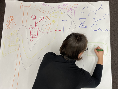
Body Mapping the Digital: Visually representing the impact of technology on archaeological practice.Understanding archaeological documentation through a participatory, arts-based approachRecommended by Nicolo Dell'Unto based on reviews by 2 anonymous reviewersThis paper presents the use of a participatory arts-based methodology to understand how digital and analogue tools affect individuals' participation in the process of archaeological recording and interpretation. The preliminary results of this work highlight the importance of rethinking archaeologists' relationship with different recording methods, emphasising the need to recognise the value of both approaches and to adopt a documentation strategy that exploits the strengths of both analogue and digital methods. Although a larger group of participants with broader and more varied experience would have provided a clearer picture of the impact of technology on current archaeological practice, the article makes an important contribution in highlighting the complex and not always easy transition that archaeologists trained in analogue methods are currently experiencing when using digital technology. This is assessed by using arts-based methodologies to enable archaeologists to consider how digital technologies are changing the relationship between mind, body and practice. I found the range of experiences described in the papers by the archaeologists involved in the experiment particularly interesting and very representative of the change in practice that we are all experiencing. As the article notes, the two approaches cannot be directly compared because they offer different possibilities: if analogue methods foster a deeper connection with the archaeological material, digital documentation seems to be perceived as more effective in terms of data capture, information exchange and data sharing (Araar et al., 2023). It seems to me that an important element to consider in such a study is the generational shift and the incredible divide between native and non-native digital. The critical issues highlighted in the paper are central and provide important directions for navigating this ongoing (digital) transition. References Araar, L., Morgan, C. and Fowler, L. (2023) Body Mapping the Digital: Visually representing the impact of technology on archaeological practice., Zenodo, 7990581, ver. 5 peer-reviewed and recommended by Peer Community in Archaeology. https://doi.org/10.5281/zenodo.7990581 | Body Mapping the Digital: Visually representing the impact of technology on archaeological practice. | Araar, Leila; Morgan, Colleen; Fowler, Louise | <p>This paper uses a participatory, art-based methodology to understand how digital and analog tools impact individuals' experience and perceptions of archaeological recording. Body mapping involves the co-creation of life-sized drawings and narra... | | Computational archaeology, Theoretical archaeology | Nicolo Dell'Unto | 2023-06-01 09:06:52 |


