
Latest recommendations

| Id | Title | Authors | Abstract | Picture | Thematic fields▼ | Recommender | Reviewers | Submission date | |
|---|---|---|---|---|---|---|---|---|---|
20 Mar 2024
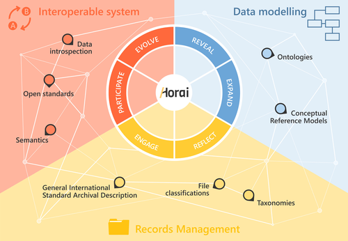
HORAI: An integrated management model for historical informationA novel management model for historical informationRecommended by Isto Huvila based on reviews by Leandro Sánchez Zufiaurre and 1 anonymous reviewerThe paper “HORAI: An integrated management model for historical information” presents a novel model for managing historical information. The study draws from an extensive indepth work in historical information management and a multi-disciplinary corpus of research ranging from heritage infrastructure research and practice to information studies and archival management literature. The paper ties into several key debates and discussions in the field showing awareness of the state-of-the-art of data management practice and theory. The authors argue for a new semantic data model HORAI and link it to a four-phase data management lifecycle model. The conceptual work is discussed in relation to three existing information systems partly predating and partly developed from the outset of the HORAI-model. While the paper shows appreciable understanding of the practical and theoretical state-of-the-art and the model has a lot of potential, in its current form it is still somewhat rough on the edges. Many of the both practical and theoretical threads introduced in the text warrant also more indepth consideration and it will be interesting to follow how the work will proceed in the future. For example, the comparison of the HORAI model and the ISAD(G): General International Standard Archival Description standard in the figure 1 is interesting but would require more elaboration. A slightly more thorough copyediting of the text would have also been helpful to make it more approachable. As a whole, in spite of the critique, I find both the paper and the model as valuable contributions to the literature and the practice of managing historical information. The paper reports thorough work, provides a lot of food for thought and several interesting lines of inquiry in the future. ReferencesDel Fresno Bernal, P., Medina Gordo, S. and Travé Allepuz, E. (2024). HORAI: An integrated management model for historical information. CAA 2023, Amsterdam, Netherlands. https://doi.org/10.5281/zenodo.8185510 | HORAI: An integrated management model for historical information | Pablo del Fresno Bernal, Sonia Medina Gordo and Esther Travé Allepuz | <p>The archiving process goes beyond mere data storage, requiring a theoretical, methodological, and conceptual commitment to the sources of information. We present Horai as a semantic-based integration model designed to facilitate the development... | | Computational archaeology, Spatial analysis | Isto Huvila | 2023-07-26 09:33:58 | ||
02 Jan 2024
Advancing data quality of marine archaeological documentation using underwater robotics: from simulation environments to real-world scenariosBeyond Deep Blue: Underwater robotics, simulations and archaeologyRecommended by Daniel Carvalho based on reviews by Marco Moderato and 1 anonymous reviewerDiamanti et al. (2024) is a significant contribution to the field of underwater robotics and their use in archaeology, with an innovative approach to some major problems in the deployment of said technologies. It identifies issues when it comes to approaching Underwater Cultural Heritage (UCH) sites and does so through an interest in the combination of data, maneuverability, and the interpretation provided by the instruments that archaeologists operate. The article's motives are clear: it is not enough to find the means to reach these sites, but rather is fundamental to take a step forward in methodology and how we can safeguard certain aspects of data recovery with robust mission planning. To this end, the article does not fail to highlight previous contributions, in an intertwined web of references that demonstrate the marked evolution of the use of Unmanned Underwater Vehicles (UUVs), Remote Operated Vehicles (ROVs), Autonomous Underwater Vehicles (AUVs) and Autonomous Surface Vehicles (ASVs), which are growing exponentially in use (see Kapetanović et al. 2020). It should be emphasized that the notion of ‘aquatic environment’ used here is quite broad and is not limited to oceanic or maritime environments, which allows for a larger perspective on distinct technologies that proliferate in underwater archaeology. There is also a relevant discussion on the typologies of sensors and how these autonomous vehicles obtain their data, where are debated Inertial Measurement Units (IMU) and LiDAR systems. Thus, the authors of this article propose the creation of a model that acquires data through simulations, which allows for a better understanding of what a real mission presupposes in the field. Their tripartite method - pre-mission planning; mission plan and post-mission plan - offers a performing algorithm that simplifies and provides reliability to all the parts of the intervention. The use of real cases to create simulation models allows for a substantial approximation to common practice in underwater environments. And yet, the article is at its most innovative status when it combines all the elements it sets out to explore. It could simply focus on the methodological or planning component, on obtaining data, or on theoretical problems. But it goes further, which makes this approach more complete and of interest to the archaeological community. By not taking any part as isolated, the problems and possible solutions arising from the course of the mission are carried over from one parameter to another, where details are worked upon and efficiency goals are set. One of the most significant cases is the tuning of ocean optics in aquatic environments according to the idiosyncracies of real cases (Diamanti et al. 2024: 8), a complex endeavor but absolutely necessary in order to increase the informative potential of the simulation. The exploration of various data capture models is also welcome, for the purposes of comparison and adaptation on a case-by-case basis. The brief theoretical reflection offered at the end of the article dwells in all these points and problematizes the difference between terrestrial and aquatic archaeology. In fact, the distinction does not only exist in the technical component, as although it draws in theoretical elements from archaeology that is carried out on land (see Krieger 2012 for this matter), the problems and interpretations are shaped by different factors and therefore become unique (Diamanti et al 2024: 15). The future, according to the authors, lies in increasing the autonomy of these vehicles so that the human element does not have to make decisions in a systematic way. It is in that note, and in order for that path to become closer to reality, that we strongly recommend this article for publication, in conjunction with the comments of the reviewers. We hope that its integrated approach, which brings together methods, theories and reflections, can become a broader modus operandi within the field of underwater robotics applied to archaeology. References: Diamanti, E., Yip, M., Stahl, A. and Ødegård, Ø. (2024). Advancing data quality of marine archaeological documentation using underwater robotics: from simulation environments to real-world scenarios, Zenodo, 8305098, ver. 4 peer-reviewed and recommended by Peer Community in Archaeology. https://doi.org/10.5281/zenodo.8305098 Kapetanović, N., Vasilijević, A., Nađ, Đ., Zubčić, K., and Mišković, N. (2020). Marine Robots Mapping the Present and the Past: Unraveling the Secrets of the Deep. Remote Sensing, 12(23), 3902. MDPI AG. http://dx.doi.org/10.3390/rs12233902 Krieger, W. H. (2012). Theory, Locality, and Methodology in Archaeology: Just Add Water? HOPOS: The Journal of the International Society for the History of Philosophy of Science, 2(2), 243–257. https://doi.org/10.1086/666956
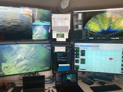
| Advancing data quality of marine archaeological documentation using underwater robotics: from simulation environments to real-world scenarios | Diamanti, Eleni; Yip, Mauhing; Stahl, Annette; Ødegård, Øyvind | <p>This paper presents a novel method for visual-based 3D mapping of underwater cultural heritage sites through marine robotic operations. The proposed methodology addresses the three main stages of an underwater robotic mission, specifically the ... | | Computational archaeology, Remote sensing | Daniel Carvalho | 2023-08-31 16:03:10 | ||
20 Feb 2024
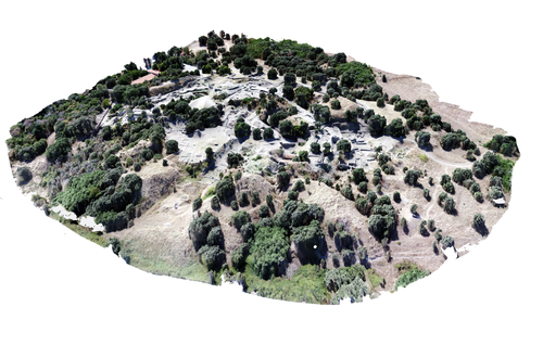
Understanding Archaeological Site Topography: 3D Archaeology of ArchaeologyRewriting Archaeological Narratives: Archaeology of Archaeology through 3D Site Topography RecordingRecommended by Devi Taelman based on reviews by Geert Verhoeven, Jesús García-Sánchez and Catherine Scott based on reviews by Geert Verhoeven, Jesús García-Sánchez and Catherine Scott
Even though applications of 3D recording have existed in archaeology for a long time, it is only since the early 2000s that this field of research has become mainstream thanks to technological advances, and the availability of low-cost sensors and image-based modelling software. This has led to significant changes in the way archaeological sites are documented. This paper entitled "Understanding Archaeological Site Topography: 3D Archaeology of Archaeology" by Jitte Waagen & Gert Jan van Wijngaarden (2024) presents an overview of the current developments in the application possibilities of 3D site topography recording in archaeology. The paper is the result of the round table discussion "Understanding Archaeological Site Topography: 3D Archaeology of Archaeology" at the CAA conference on 5 April 2023 in Amsterdam, with contributions from Radu Brunchi, Nicola Lercari, Joep Orbons, Davide Tanasi, Alicia Walsh, Pawel Wolf and Teagan Zoldoske. The paper starts with a discussion of the Amsterdam Troy Project (ATP). In the frame of the ATP, the rich history of archaeological activity (over 150 years of fieldwork) at Troy is being studied to explore how previous archaeological research has helped to shape the current topography of the site and how these earlier research activities, embedded in their contemporary theoretical frameworks, have determined our understanding of the site (see Murray and M. Spriggs 2017, Carver 2011 for the influence of theory on archaeological fieldwork and archaeology as a discipline), the so-called 'Archaeology of Archaeology' approach. In addition to studying previous research records and re-excavating old excavation trenches, a central element of the project is the 3D recording of the past and present topography of the site in order to reconstruct the archaeological research activities at the site and their impact on the archaeological landscape. The paper focuses on current trends in 3D recording of archaeological site topography and discusses three main areas where 3D recording of archaeological site topography can contribute to the "Archaeology of Archaeology" approach: (1) monitoring the topography of sites for preservation, conservation, research and dissemination purposes; (2) reconstructing, reevaluating and reinterpreting past archaeological research efforts; and (3) archiving in a 4D (GIS) environment. This is done using the example of the Amsterdam Troy project and comparing it with other projects using similar methods and approaches. Using these case studies, the authors effectively discuss the impact of these technologies on the understanding of the topography of archaeological sites and how 3D recording can enhance archaeological research methodologies and interpretations, for example, by not using such 3D approaches as a stand-alone product but integrating them with available information from previous research activities. They also recognise the limitations and challenges involved, such as the need for customised data acquisition strategies and the lack of ready-made software solutions for developing comprehensive data management strategies. One topic that could have been covered in more detail is how 3D site topography recording (and 3D recording in general) is affected by current theoretical developments in archaeology. Like any other archaeological fieldwork or data collection approach, it is a child of its time. Decisions such as what to record, how to record, what to store, how to store, what to visualise, and how to visualise influence our understanding of archaeological sites (Ward 2022). This minor critical reflection aside, the paper makes a timely and significant contribution to archaeology by addressing current trends and the limitations of the increasingly widespread use of 3D site topography recording technologies. References Carver, G. (2011). Reflections on the archaeology of archaeological excavation, Archaeological Dialogues 18(1), pp. 18–26. https://doi.org/10.1017/S1380203811000067 Murray, T. and Spriggs, M. (2017). The historiography of archaeology: exploring theory, contingency and rationality, World Archaeology 49(2), pp. 151–157. https://doi.org/10.1080/00438243.2017.1334583 Ward, C. (2022). Excavating the Archive / Archiving the Excavation: Archival Processes and Contexts in Archaeology, Advances in Archaeological Practice 10(2), pp. 160–176. https://doi.org/10.1017/aap.2022.1 Waagen, J. and van Wijngaarden, G.J. (2024). Understanding Archaeological Site Topography: 3D Archaeology of Archaeology, Zenodo, 10061343, ver. 3 peer-reviewed and recommonded by Peer Community in Archaeology. https://doi.org/10.5281/zenodo.10061343 | Understanding Archaeological Site Topography: 3D Archaeology of Archaeology | Waagen, Jitte & Wijngaarden, Gert Jan van | <p>The current ubiquitous use of 3D recording technologies in archaeological fieldwork, for a large part due to the application of budget-friendly (drone) sensors and the availability of many low-cost image-based 3D modelling software packages, ha... | | Computational archaeology, Remote sensing | Devi Taelman | 2023-10-17 23:03:47 | ||
08 Apr 2024
Spaces of funeral meaning. Modelling socio-spatial relations in burial contextsA new approach to a data ontology for the qualitative assessment of funerary spacesRecommended by Asuman Lätzer-Lasar based on reviews by 2 anonymous reviewers
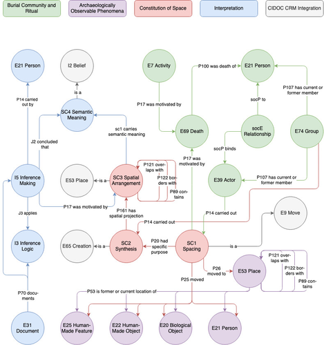
The paper by Aline Deicke [1] is very readable, and it succeeds in presenting a still unnoticed topic in a well-structured way. It addresses the topic of “how to model social-spatial relations in antiquity”, as the title concisely implies, and makes important and interesting points about their interrelationship by drawing on latest theories of sociologists such as Martina Löw combined with digital tools, such as the CIDOC CRM-modeling. The author provides an introductory insight into the research history of funerary archaeology and addresses the problematic issue of not having investigated fully the placement of entities of the grave inventory. So far, the focus of the analysis has been on the composition of the assemblage and not on the positioning within this space-and time-limited context. However, the positioning of the various entities within the burial context also reveals information about the objects themselves, their value and function, as well as about the world view and intentions of the living and dead people involved in the burial. To obtain this form of qualitative data, the author suggests modeling knowledge networks using the CIDOC CRM. The method allows to integrate the spatial turn combined with aspects of the actor-network-theory. The theoretical backbone of the contribution is the fundamental scholarship of Martina Löw’s “Raumsoziologie” (sociology of space), especially two categories of action namely placing and spacing (SC1). The distinction between the two types of action enables an interpretative process that aims for the detection of meaningfulness behind the creation process (deposition process) and the establishment of spatial arrangement (find context). To illustrate with a case study, the author discusses elite burial sites from the Late Urnfield Period covering a region north of the Alps that stretches from the East of France to the entrance of the Carpathian Basin. With the integration of very basic spatial relations, such as “next to”, “above”, “under” and qualitative differentiations, for instance between iron and bronze knives, the author detects specific patterns of relations: bronze knives for food preparing (ritual activities at the burial site), iron knives associated with the body (personal accoutrement). The complexity of the knowledge engineering requires the gathering of several CIDOC CRM extensions, such as CRMgeo, CRMarchaeo, CRMba, CRMinf and finally CRMsoc, the author rightfully suggests. In the end, the author outlines a path that can be used to create this kind of data model as the basis for a graph database, which then enables a further analysis of relationships between the entities in a next step. Since this is only a preliminary outlook, no corrections or alterations are needed. The article is an important step in advancing digital archaeology for qualitative research. References [1] Deicke, A. (2024). Spaces of funeral meaning. Modelling socio-spatial relations in burial contexts. Zenodo, 8310170, ver. 4 peer-reviewed and recommended by Peer Community in Archaeology. https://doi.org/10.5281/zenodo.8310170 | Spaces of funeral meaning. Modelling socio-spatial relations in burial contexts | Aline Deicke | <p>Burials have long been one of the most important sources of archaeology, especially when studying past social practices and structure. Unlike archaeological finds from settlements, objects from graves can be assumed to have been placed there fo... | | Computational archaeology, Protohistory, Spatial analysis, Theoretical archaeology | Asuman Lätzer-Lasar | 2023-09-01 23:15:41 | ||
02 Apr 2024
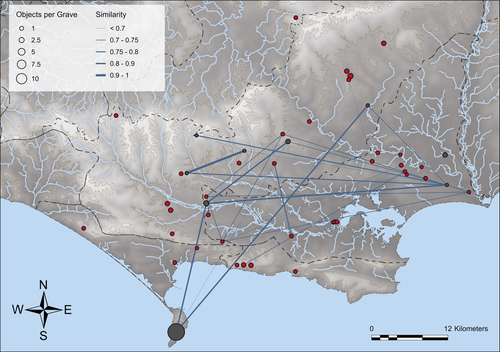
Similarity Network Fusion: Understanding Patterns and their Spatial Significance in Archaeological DatasetsA different approach to similarity networks in Archaeology - Similarity Network FusionRecommended by Joel Santos based on reviews by Matthew Peeples and 1 anonymous reviewerThis is a fascinating paper for anyone interested in network analysis or the chronology and cultures of the case study, namely the Late prehistoric burial sites in Dorset, for which the author’s approach allowed a new perspective over an already deeply studied area [1]. This paper's implementation of Similarity Network Fusion (SNF) is noteworthy. This method is typically utilized within genetic research but has yet to be employed in Archaeology. SNF has the potential to benefit Archaeology due to its unique capabilities and approach significantly. The author exhibits a deep and thorough understanding of previous investigations concerning material and similarity networks while emphasizing the innovative nature of this particular study. The SNF approach intends to improve a lack of the most used (in Archaeology) similarity coefficient, the Brainerd-Robinson, in certain situations, mainly in heterogenous and noisy datasets containing a small number of samples but a large number of measurements, scale differences, and collection biases, among other things. The SNF technique, demonstrated in the case study, effectively incorporates various similarity networks derived from different datatypes into one network. As shown during the Dorset case study, the SNF application has a great application in archaeology, even in already available data, allowing us to go further and bring new visions to the existing interpretations. As stated by the author, SNF shows its potential for other applications and fields in archaeology coping with similar datasets, such as archaeobotany or archaeozoology, and seems to complement different multivariate statistical approaches, such as correspondence or cluster analysis. This paper has been subject to two excellent revisions, which the author mostly accepted. One of the revisions was more technical, improving the article in the metadata part, data availability and clarification, etc. Although the second revision was more conceptual and gave some excellent technical inputs, it focused more on complementary aspects that will allow the paper to reach a wider audience. I vividly recommend its publication. References [1] Geitlinger, T. (2024). Similarity Network Fusion: Understanding Patterns and their Spatial Significance in Archaeological Datasets. Zenodo, 7998239, ver. 3 peer-reviewed and recommended by Peer Community in Archaeology. https://doi.org/10.5281/zenodo.7998239
| Similarity Network Fusion: Understanding Patterns and their Spatial Significance in Archaeological Datasets | Timo Geitlinger | <p>Since its earliest application in the 1970s, network analysis has become increasingly popular in both theoretical and GIS-based archaeology. Yet, applications of material networks remained relatively restricted. This paper describes a specific ... | | Computational archaeology, Protohistory | Joel Santos | 2023-06-02 16:51:19 | ||
01 Dec 2022
Surface texture analysis in Toothfrax and MountainsMap® SSFA module: Different software packages, different results?An important comparison of software for Scale Sensitive Fractal Analysis : are ancient and new results compatible?Recommended by Alain Queffelec and Florent Rivals based on reviews by Antony Borel and 2 anonymous reviewers
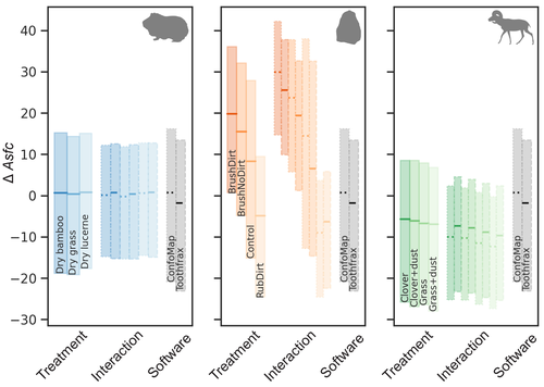
The community of archaeologists, bioanthropologist and paleontologists relying on tools use-wear and dental microwear has grown in the recent years, mainly driven by the spread of confocal microscopes in the laboratories. If the diversity of microscopes is quite high, the main software used for 3D surface texture data analysis are mostly different versions of the same Mountains Map core. In addition to this software, since the beginning of 3D surface texture analysis in dental microwear, surface sensitive fractal analysis (SSFA) initially developed for industrial research (Brown & Savary, 1991) have been performed in our disciplines with the Sfrax/Toothfrax software for two decades (Ungar et al., 2003). This software being discontinued, these calculations have been integrated to the new versions of Mountains Map, with multi-core computing, full integration in the software and an update of the calculation itself. New research based on these standard parameters of surface texture analysis will be, from now on, mainly calculated with this new add-on of Mountains Map, and will be directly compared with the important literature based on the previous software. The question addressed by Calandra et al. (2022), gathering several prominent researchers in this domain including the Mountains Map developer F. Blateyron, is key for the future research: can we directly compare SSFA results from both software? Thanks to a Bayesian approach to this question, and comparing results calculated with both software on three different datasets (two on dental microwear, one on lithic raw materials), the authors show that the two software gives statistically different results for all surface texture parameters tested in the paper. Nevertheless, applying the new calculation to the datasets, they also show that the results published in original studies with these datasets would have been similar. Authors also claim that in the future, researchers will need to re-calculate the fractal parameters of previously published 3D surfaces and cannot simply integrate ancient and new data together. We also want to emphasize the openness of the work published here. All datasets have been published online and will be probably very useful for future methodological works. Authors also published their code for statistical comparison of datasets, and proposed a fully reproducible article that allowed the reviewers to check the content of the paper, which can also make this article of high interest for student training. This article is therefore a very important methodological work for the community, as noted by all three reviewers. It will certainly support the current transition between the two software packages and it is necessary that all surface texture specialists take these results and the recommendation of authors into account: calculate again data from ancient measurements, and share the 3D surface measurements on open access repositories to secure their access in the future. References Brown CA, and Savary G (1991) Describing ground surface texture using contact profilometry and fractal analysis. Wear, 141, 211–226. https://doi.org/10.1016/0043-1648(91)90269-Z Calandra I, Bob K, Merceron G, Blateyron F, Hildebrandt A, Schulz-Kornas E, Souron A, and Winkler DE (2022) Surface texture analysis in Toothfrax and MountainsMap® SSFA module: Different software packages, different results? Zenodo, 7219877, ver. 4 peer-reviewed and recommended by Peer Community in Archaeology. https://doi.org/10.5281/zenodo.7219877 Ungar PS, Brown CA, Bergstrom TS, and Walker A (2003) Quantification of dental microwear by tandem scanning confocal microscopy and scale-sensitive fractal analyses. Scanning: The Journal of Scanning Microscopies, 25, 185–193. https://doi.org/10.1002/sca.4950250405 | Surface texture analysis in Toothfrax and MountainsMap® SSFA module: Different software packages, different results? | Ivan CALANDRA, Konstantin BOB, Gildas MERCERON, François BLATEYRON, Andreas HILDEBRANDT, Ellen SCHULZ-KORNAS, Antoine SOURON, Daniela E. WINKLER | <p>The scale-sensitive fractal analysis (SSFA) of dental microwear textures is traditionally performed using the software Toothfrax. SSFA has been recently integrated to the software MountainsMap® as an optional module. Meanwhile, Toothfrax suppor... | | Computational archaeology, Palaeontology, Traceology | Alain Queffelec | Anonymous, John Charles Willman, Antony Borel | 2022-07-07 09:58:50 | |
12 Feb 2024
3Duewelsteene - A website for the 3D visualization of the megalithic passage grave Düwelsteene near Heiden in Westphalia, GermanyOnline presentation of the digital reconstruction process of a megalithic tomb : “3Duewelsteene”Recommended by Sophie C. Schmidt and James Allison based on reviews by Robert Bischoff, Ronald Visser and Scott Ure
“3Duewelsteene - A website for the 3D visualization of the megalithic passage grave Düwelsteene near Heiden in Westphalia, Germany” (Tharandt 2024) presents several 3-dimensional models of the Düwelsteene monument, along with contextual information about the grave and the process of creating the models. The website (https://3duewelsteene.github.io/) includes English and German versions, making it accessible to a wide audience. The website itself serves as the primary means of presenting the data, rather than as a supplement to a written text. This is an innovative and engaging way to present the research to a wider public. Düwelsteene (“Devil’s Stones”) is a megalithic passage grave from the Funnel Beaker culture, dating to approximately 3300 BC. to 2600 BC. that was excavated in 1932. The website displays three separate 3-dimensional models. They ares shown in the 3D viewer software 3DHOP, which enables viewers to interact with the models in several ways, Annotations on the models display further information. The first model was created by image-based modeling and shows the monument as it appears today. A second model uses historical photographs and excavation data to reconstruct the grave as it appeared prior to the 1932 archaeological excavation. Restoration work following the excavation relocated many of the stones. Pre-1932 photographs collected from residents of the nearby town of Heiden were then used to create a model showing what the tomb looked like before the restoration work. It is commendable that a “certainty view” of the model shows the certainty with which the stones can be put at the reconstructed place. Gaps in the 3D models of stones that were caused by overlap with other stones have been filled with a rough mesh and marked as such, thereby differentiating between known and unknown parts of the stones. The third model is the most imaginative and most interesting. As it shows as the grave as it might have appeared in approximately 3000 B.C., many aspects of this model are necessarily somewhat speculative. There is no direct evidence for exact size and shape of the capstones, the height of the mound, and other details. But enough is known about other similar constructions to allow these details to be inferred with some confidence. Again, care was taken to enable viewers to distinguish between the stones that are still in existence and those that were reconstructed. A video on the home page of the website adds a nice touch. It starts with the model of the Düwelsteene as it currently appears then shows, in reverse order, the changes to the grave, ending with the inferred original state. The 3D reconstructions are convincing and the methods well described. This project follows an open science approach and the FAIR principles, which is commendable and cutting edge in the field of Digital Archaeology. The preprint of the website hosted on zenodo includes all the photos, text, html files, and nine individual 3D model (.ply) files that are combined in the reconstructions exhibited on the website. A “readme.md” file includes details about building the models using CloudCompare and Blender, and modifications to the 3D viewer software (3DHOP) to get the website to improve the display of the reconstructions. We have to note that the link between the reconstructed models and the html page does not work when the files are downloaded from zenodo and opened offline. The html pages open in the browser, and the individual ply files work fine, but the 3D models do not display on the browser page when the html files are opened offline. The online version of the website is working perfectly. The 3Düwelsteene website combines the presentation of archaeological domain knowledge to a lay audience as well as in-depths information on the reconstruction process to make it an interesting contribution for researchers. By providing data and code for the website it also models an Open Science approach, which enables other researchers to re-use these materials. We congratulate the author on a successful reconstruction of the megalithic tomb, an admirable presentation of the archaeological work and the thoughtful outreach to a broad audience. Bibliography | 3Duewelsteene - A website for the 3D visualization of the megalithic passage grave Düwelsteene near Heiden in Westphalia, Germany | Tharandt, Louise | <p>The Düwelsteene near Heiden, Westphalia, is one of the most southern megalithic tombs of the Funnel Beaker culture. In 1932 the Düwelsteene were restored and the appearance of the grave was changed. Even though the megalithic tomb was excavated... | | Computational archaeology, Mesolithic, Neolithic | Sophie C. Schmidt | 2023-05-21 17:24:22 | ||
12 Apr 2024
Survey Planning, Allocation, Costing and Evaluation (SPACE) Project: Developing a Tool to Help Archaeologists Conduct More Effective SurveysA new tool to increase the robustness of archaeological field surveyRecommended by Jitte Waagen based on reviews by Philip Verhagen and Tymon de Haas
This well-written and interesting paper ‘Survey Planning, Allocation, Costing and Evaluation (SPACE) Project: Developing a Tool to Help Archaeologists Conduct More Effective Surveys’ deals with the development of a ‘modular, accessible, and simple web-based platform for survey planning and quality assurance’ in the area of pedestrian field survey methods (Banning et al. 2024). Although there have been excellent treatments of statistics in archaeological field survey (among which various by the first author: Banning 2020, 2021), and there is continuous methodological debate on platforms such as the International Mediterranean Survey Workshop (IMSW), in papers dealing with the current development and state of the field (Knodell et al. 2023), good practices (Attema et al. 2020) or the merits of a quantifying approach to archaeological densities (cf. de Haas et al. 2023), this paper rightfully addresses the lack of rigorous statistical approaches in archaeological field survey. As argued by several scholars such as Orton (2000), this mainly appears the result of lack of knowledge/familiarity/resources to bring in the required expertise etc. with the application of seemingly intricate statistics (cf. Waagen 2022). In this context this paper presents a welcome contribution to the feasibility of a robust archaeological field survey design. The SPACE application, under development by the authors, is introduced in this paper. It is a software tool that aims to provide different modules to assist archaeologists to make calculations for sample size, coverage, stratification, etc. under the conditions of survey goals and available resources. In the end, the goal is to ensure archaeological field surveys will attain their objectives effectively and permit more confidence in the eventual outcomes. The module concerning Sweep Widths, an issue introduced by the main author in 2006 (Banning 2006) is finished; the sweep width assessment is a methodology to calibrate one’s survey project for artefact types, landscape, visibility and person-bound performance, eventually increasing the quality (comparability) of the collected samples. This is by now a well-known calibration technique, yet little used, so this effort to make that more accessible is certainly laudable. An excellent idea, and another aim of this project, is indeed to build up a database with calibration data, so applying sweep-width corrections will become easier accessible to practitioners who lack time to set up calibration exercises. It will be very interesting to have a closer look at the eventual platform and to see if, and how, it will be adapted by the larger archaeological field survey community, both from an academic research perspective as from a heritage management point of view. I happily recommend this paper and all debate relating to it, including the excellent peer reviews of the manuscript by Philip Verhagen and Tymon de Haas (available as part of this PCI recommendation procedure), to any practitioner of archaeological field survey. References Attema, P., Bintliff, J., Van Leusen, P.M., Bes, P., de Haas, T., Donev, D., Jongman, W., Kaptijn, E., Mayoral, V., Menchelli, S., Pasquinucci, M., Rosen, S., García Sánchez, J., Luis Gutierrez Soler, L., Stone, D., Tol, G., Vermeulen, F., and Vionis. A. 2020. “A guide to good practice in Mediterranean surface survey projects”, Journal of Greek Archaeology 5, 1–62. https://doi.org/10.32028/9781789697926-2 Banning, E.B., Alicia L. Hawkins, S.T. Stewart, Sweep widths and the detection of artifacts in archaeological survey, Journal of Archaeological Science, Volume 38, Issue 12, 2011, Pages 3447-3458. https://doi.org/10.1016/j.jas.2011.08.007 Banning, E.B. 2020. Spatial Sampling. In: Gillings, M., Hacıgüzeller, P., Lock, G. (eds.) Archaeological Spatial Analysis. A Methodological Guide. Routledge. Banning, E.B. 2021. Sampled to Death? The Rise and Fall of Probability Sampling in Archaeology. American Antiquity, 86(1), 43-60. https://doi.org/10.1017/aaq.2020.39 Banning, E. B. Steven Edwards, & Isaac Ullah. (2024). Survey Planning, Allocation, Costing and Evaluation (SPACE) Project: Developing a Tool to Help Archaeologists Conduct More Effective Surveys. Zenodo, 8072178, ver. 9 peer-reviewed and recommended by Peer Community in Archaeology. https://doi.org/10.5281/zenodo.8072178 Knodell, A.R., Wilkinson, T.C., Leppard, T.P. et al. 2023. Survey Archaeology in the Mediterranean World: Regional Traditions and Contributions to Long-Term History. J Archaeol Res 31, 263–329 (2023). https://doi.org/10.1007/s10814-022-09175-7 Orton, C. 2000. Sampling in Archaeology. Cambridge University Press. https://doi.org/10.1017/CBO9781139163996 Waagen, J. 2022. Sampling past landscapes. Methodological inquiries into the bias problems of recording archaeological surface assemblages. PhD-Thesis. https://hdl.handle.net/11245.1/e9cb922c-c7e4-40a1-b648-7b8065c46880 de Haas, T., Leppard, T. P., Waagen, J., & Wilkinson, T. (2023). Myopic Misunderstandings? A Reply to Meyer (JMA 35(2), 2022). Journal of Mediterranean Archaeology, 36(1), 127-137. https://doi.org/10.1558/jma.27148 | Survey Planning, Allocation, Costing and Evaluation (SPACE) Project: Developing a Tool to Help Archaeologists Conduct More Effective Surveys | E. B. Banning, Steven Edwards, and Isaac Ullah | <p>Designing an effective archaeological survey can be complicated and confidence that it was effective requires post-survey evaluation. The goal of SPACE is to develop software to facilitate survey designers’ decisions and partially automate tool... | | Computational archaeology, Landscape archaeology | Jitte Waagen | 2023-06-28 13:42:28 | ||
22 Apr 2024
The transformation of an archaeological community and its resulting representations in the context of the co-development of open Archaeological Information SystemsExploring The Role of Archaeological Information Systems in Improving Data Management and InteroperabilityRecommended by James Stuart Taylor based on reviews by 2 anonymous reviewers
In response to the feedback provided by the reviewers, the authors have undertaken a comprehensive revision of the manuscript [1]. These revisions have specifically targeted the primary concerns raised regarding the clarity and structure of the argument concerning the transformative impact of Archaeological Information Systems (AIS) on archaeological practices. In my view the revised manuscript now more clearly articulates the distinction between internal and external interoperability and emphasizes the critical importance of integrating contextual information with archaeological data. This approach directly addresses the previously identified need for enhanced traceability and usability of archaeological data, ensuring that the manuscript's contributions to the field are both clear and impactful. Moreover, the application of the proposed model at the Bibracte site is illustrated with greater clarity, serving as a concrete example of how the challenges associated with documentation and data management can be effectively addressed through the methodologies proposed in the paper. This practical demonstration enriches the manuscript, providing readers with a much clearer understanding of the model's applicability and benefits in real-world archaeological practice. The authors have also made significant efforts to refine the overall structure and coherence of the manuscript. By making complex concepts more accessible and ensuring a cohesive narrative flow throughout, the manuscript now offers a more engaging and comprehensible read. This has been achieved through careful rephrasing and restructuring of sections, particularly those relating to the T!O model's application and the conclusion, thereby enhancing reader engagement and comprehension. Alongside these structural and conceptual clarifications, explicit discussion of potential areas for future research, not only acknowledges the limitations of the current study but also highlights the significant potential for digital technologies to contribute to archaeological methodology and knowledge production. As such, the manuscript opens up new avenues for exploration and invites further scholarly engagement with the topics it addresses. I believe, these revisions address the earlier feedback quite comprehensively, presenting a robust and compelling argument for the adoption of collaborative and technologically informed approaches in the field of archaeology. The manuscript now stands as a strong example of the critical role AIS could/should play in transforming archaeological practices, offering valuable insights into how these kinds of systems might enhance the management, accessibility, and understanding of archaeological data. Through this revised submission, the authors have significantly strengthened their contribution to the ongoing discourse on digital archaeology, demonstrating the practical and theoretical implications of their work for the broader archaeological community. I am happy, therefore to recommend this paper for acceptence. Reference [1] Lacombe, E., Lukas, D. and Durost, S. (2024). The transformation of an archaeological community and its resulting representations in the context of the co-development of open Archaeological Information Systems. Zenodo, 8309732, ver. 3 peer-reviewed and recommended by Peer Community in Archaeology. https://doi.org/10.5281/zenodo.8309732
| The transformation of an archaeological community and its resulting representations in the context of the co-development of open Archaeological Information Systems | Eric Lacombe, Dominik Lukas, Sébastien Durost | <p>The adoption of Archaeological Information Systems (AIS) evolves according to multiple factors, both human and technical, as well as endogenous and exogenous. In consequence the ever increasing scope of digital tools, which allow for the organi... | | Computational archaeology, Europe, Protohistory, Theoretical archaeology | James Stuart Taylor | 2023-09-01 18:58:26 | ||
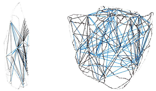
10 Jan 2024
Linking Scars: Topology-based Scar Detection and Graph Modeling of Paleolithic Artifacts in 3DA valuable contribution to automated analysis of palaeolithic artefactsRecommended by Sebastian Hageneuer based on reviews by Lutz Schubert and 1 anonymous reviewer
In this paper (Linsel/Bullenkamp/Mara 2024), the authors propose an automatic system for scar-ridge-pattern detection on palaeolithic artefacts based on Morse Theory. Scare-Ridge pattern recognition is a process that is usually done manually while creating a drawing of the object itself. Automatic systems to detect scars or ridges exist, but only a small amount of them is utilizing 3D data. In addition to the scar-ridges detection, the authors also experiment in automatically detecting the operational sequence, the temporal relation between scars and ridges. As a result, they can export a traditional drawing as well as graph models displaying the relationships between the scars and ridges. After an introduction to the project and the practice of documenting palaeolithic artefacts, the authors explain their procedure in automatising the analysis of scars and ridges as well as their temporal relation to each other on these artefacts. To illustrate the process, an open dataset of lithic artefacts from the Grotta di Fumane, Italy, was used and 62 artefacts selected. To establish a Ground Truth, the artefacts were first annotated manually. The authors then continue to explain in detail each step of the automated process that follows and the results obtained. In the second part of the paper, the results are presented. First the results of the segmentation process shows that the average percentage of correctly labelled vertices is over 91%, which is a remarkable result. The graph modelling however shows some more difficulties, which the authors are aware of. To enhance the process, the authors rightfully aim to include datasets of experimental archaeology in the future. They also aim to develop a way of detecting the operational sequence automatically and precisely. This paper has great potential as it showcases exactly what Digital and Computational Archaeology is about: The development of new digital methods to enhance the analysis of archaeological data. While this procedure is still in development, the authors were able to present a valuable contribution to the automatization of analytical archaeology. By creating a step towards the machine-readability of this data, they also open up the way to further steps in machine learning within Archaeology. BibliographyLinsel, F., Bullenkamp, J. P., and Mara, H. (2024). Linking Scars: Topology-based Scar Detection and Graph Modeling of Paleolithic Artifacts in 3D, Zenodo, 8296269, ver. 3 peer-reviewed and recommended by Peer Community in Archaeology. https://doi.org/10.5281/zenodo.8296269 | Linking Scars: Topology-based Scar Detection and Graph Modeling of Paleolithic Artifacts in 3D | Florian Linsel, Jan Philipp Bullenkamp & Hubert Mara | <p>Motivated by the concept of combining the archaeological practice of creating lithic artifact drawings with the potential of 3D mesh data, our goal in this project is not only to analyze the shape at the artifact level, but also to enable a mor... | | Computational archaeology, Europe, Lithic technology, Upper Palaeolithic | Sebastian Hageneuer | 2023-09-01 23:03:59 |


