The Potential of Mobile 3D Documentation using Video Based Photogrammetry and iPhone 12 Pro
Towards a Mobile 3D Documentation Solution. Video Based Photogrammetry and iPhone 12 Pro as Fieldwork Documentation Tools
Abstract
Recommendation: posted 02 September 2023, validated 02 September 2023
Fung, Y. (2023) The Potential of Mobile 3D Documentation using Video Based Photogrammetry and iPhone 12 Pro. Peer Community in Archaeology, 100332. https://doi.org/10.24072/pci.archaeo.100332
Recommendation
I am pleased to recommend the paper titled "Towards a Mobile 3D Documentation Solution. Video Based Photogrammetry and iPhone 12 Pro as Fieldwork Documentation Tools" for consideration and publication as a preprint (Paukkonen, 2023). The paper addresses a timely and relevant topic within the field of archaeology and offers valuable insights into the evolving landscape of 3D documentation methods.
The advances in technology over the past decade have brought about significant changes in archaeological documentation practices. This paper makes a valuable contribution by discussing the emergence of affordable equipment suitable for 3D fieldwork documentation. Given the constraints that many archaeologists face with limited resources and tight timeframes, the comparison between photogrammetry based on a video captured by a DJI Osmo Pocket gimbal camera and iPhone 12 Pro LiDAR scans is of great significance.
The research presented in the paper showcases a practical application of these new technologies in the context of a Finnish Early Modern period archaeological project. By comparing the acquisition processes and evaluating the accuracy, precision, ease of use, and time constraints associated with each method, the authors provide a comprehensive assessment of their potential for archaeological fieldwork. This practical approach is a commendable aspect of the paper, as it not only explores the technical aspects but also considers the practical implications for archaeologists on the ground.
Furthermore, the paper appropriately addresses the limitations of these technologies, specifically highlighting their potential inadequacy for projects requiring a higher level of precision, such as Neolithic period excavations. This nuanced perspective adds depth to the discussion and provides a realistic portrayal of the strengths and limitations of the new documentation methods.
In conclusion, the paper offers valuable insights into the future of 3D field documentation for archaeologists. The authors' thorough evaluation and practical approach make this study a valuable resource for researchers, practitioners, and professionals in the field. I believe that this paper would be an excellent addition to PCIArchaeology and would contribute significantly to the ongoing dialogue within the archaeological community.
References
Paukkonen, N. (2023) Towards a Mobile 3D Documentation Solution. Video Based Photogrammetry and iPhone 12 Pro as Fieldwork Documentation Tools, Zenodo, 8281263, ver. 3 peer-reviewed and recommended by Peer Community in Archaeology. https://doi.org/10.5281/zenodo.8281263

The recommender in charge of the evaluation of the article and the reviewers declared that they have no conflict of interest (as defined in the code of conduct of PCI) with the authors or with the content of the article. The authors declared that they comply with the PCI rule of having no financial conflicts of interest in relation to the content of the article.
Finnish Academy of Science and Letters, Eino Jutikkala Fund
Evaluation round #1
DOI or URL of the preprint: https://doi.org/10.5281/zenodo.7954535
Version of the preprint: 1
Author's Reply, 13 Aug 2023
Decision by Ying Tung Fung, posted 11 Jul 2023, validated 11 Jul 2023
Dear Nikolai Paukkonen,
thank you for submitting your work to PCI Archaeology.
Three reviewers have read your manuscript and suggest minor modifications. Please follow their comments and submit a new version of your manuscript. A new clean version should be uploaded to the Zenodo repository, as well as answers to the comments and a track changes version on the PCI Archaeology website.
All the best
Reviewed by Sebastian Hageneuer , 19 Jun 2023
Title/abstract/introduction
The title does clearly reflect the content of the article. The abstract is good, but suggests a positive outcome for the use of these mobile alternatives, which is not the case in the conclusions. The introduction is very well written and clearly explains the motivation of the paper. Also, the research question of the paper is clearly formulated. Only one previous work by Luetzenburg, Kroon and Bjørk is cited that has already done some preliminary testing. More comparable articles like the one discussed here should be included, as the comparison of different scanning methods is nothing new.
Materials and Methods
The methods only consist of technical specifications of the devices used and the process of data acquisition. Is is well described and the author did calibrate the used software first, which is appropriate.
Results
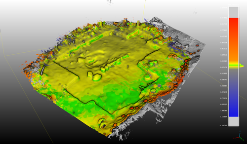
The author describes here the difference between a visual inspection of the data and the comparison of point clouds in CloudCompare. Here, I would have wished for more explanation concerning the M3C2 comparisons, as this part was not very clear (see also in Tables and Figures). The author's statement, that 2cm are within acceptable margins of error might be true for the site he was invesitgating, but this certainly isn't true for every site. I would advise to discuss more the application of these scanning results with regard to the type of excavation (Paleolithic excavations for example works quiet differently).
The author also provides scanning data, which I did not check against his own results. In any case, the results are repeatable and checkable if wished.
Discussion
The discussion is much clearer than the beginning of the paper as it clearly states that the technology tested is not capable of archieving acceptable results yet. I agree with the author that at the moment, these technologies are not sufficient and reliable enough, but this might as well change in due time. Again, here the author could refer to other works that have done similar things in the field, albeit not with the exact same techology. But comparisons between Structure-from-Motion and Laserscanning have been done many times for example. These references are missing.
References
Except the already mentioned point of former studies, the references are appropriate and seem accurate.
Tables and figures
I think Figure 7 should be three images, but I only see one. Figure 6 is very good and comprehensible. Figure 5 needs more explanation, so readers can understand what this graph actually means. Figures 3 & 4 are very good. Again, I think Figure 3 is missing images, as I only see two overlapping in the center. Figure 1 is fine. Tables are useful and comprehensive. Captions are good.
https://doi.org/10.24072/pci.archaeo.100332.rev11Reviewed by anonymous reviewer 1, 21 Jun 2023
In general terms, it is a well-written paper of an interesting topic. The language is adequate, clear, precise and consistent. Also, it is very positive that the use of innovative documentation technologies is pointed out quite frequently in the text, defining well the scope of such applications within the archaeological prospection.
Abstract and Introduction are very concise, and the general layout is also good.
The figures although are quite well captioned, it is generally recommended to be integrated with a reference link in the text, and especially for the figures presenting results.
Lidar on mobile phones is indeed something new, but video-based photogrammetry cannot be considered as novelty, as it dates back to more than a decade now, and is used massively in cultural heritage documentation.
In Methods section, line 118, you refer to time interval and number of frames, but neither in this section nor in the next one (Data acquisition) you mention the distance of the sensor (camera) from the object that defines the resolution (pixel size) of your model and the overlap within the sequential frames. Time interval is an important parameter when working with videos for photogrammetry, but it is also important to mention the overlap that results from this frame rate. And of course the spatial resolution of the images.
In Data acquisition section, line 166, it would be preferable to add the actual dimensions of the area of interest. Apart from Figure 3 where there is a scale bar (5.5 m), there is no other information about the extents of the documented area.
In line 182, there is a very interesting tool mentioned, the MSA. Maybe it would be useful to add a comment on the (almost apparent) reason why you used this tool (in order to align the different datasets, coming from different sensors which means different georeferencing etc). The fusion of data from different sensors (in this case from different GPS antennas) is an active research topic of high interest.
In Volumetric comparisons section, lines 270-271, the statement that Lidar point clouds "tend" to be more noisy that the photogrammetric ones, needs documentation. Maybe add one or two references from similar works that show this tendency?
In Conclusions section, lines 293-296, when refering to "many developers", add references.
Lines 303-312 are stating something completely inaccurate.
In line 319, define "traditional methodology". Is it surveying with total stations? Taking tape measurements? And are the results of "traditional methodology" actually comparable with photogrammetry? (Define also which results could be compared among traditional surveying and photogrammetry. Is it a distance? an area? a volume?).
To sum up, this is an interesting article about state-of-the-art and low-cost methods of documentation, but it needs to be slightly enhanced technically.
https://doi.org/10.24072/pci.archaeo.100332.rev12
Reviewed by Dominik Hagmann, 02 Jul 2023
The paper appears to be well-crafted, understandable, and demonstrates high potential. It employs state-of-the-art methods and discusses them in a comprehensible and methodologically correct manner.
However, there are a view conceptual issues which should be addressed critically:
- It is somewhat surprising that the conclusion, particularly in the first paragraph, seems to - at least partially - deviate from the general tone of the paper, especially in comparison to the general tone of the abstract. I think the conclusion of a research paper should ideally provide a succinct summary of the findings and their implications, tying together the main arguments and evidences presented in the body of the paper. If the conclusion appears to diverge from the overall narrative or argument developed in the paper, it might lead to confusion or misinterpretation for readers (at least it seems somewhat like that to me in the present case). If the divergence in the conclusion is intentional and serves a specific purpose, such as introducing a new perspective or highlighting future research directions, I think it would be best that it should be done in a manner that still aligns with the overall theme and argument of the paper. If it isn't intentional, then revising the conclusion to better reflect the paper's main points and findings would be recommended to maintain coherence and continuity. Especially regarding methodology, it is worth questioning whether the evaluation of precision and accuracy values, which are nevertheless at a very high level, may be excessively meticulous. Considering the everyday practice of archaeology (as the authors have already acknowledged in the text), it's clear that laboratory conditions cannot be assumed. Consequently, the conclusions should be tempered when considering field conditions, which are often influenced by extreme weather conditions, time pressure, and restrictive budgetary constraints. In light of these considerations, it may be more appropriate to view smart devices in a somewhat more favorable light, as they make a significant contribution to the further democratization of technology. Specifically, they make LiDAR and photogrammetry technologies more accessible to a wider audience. The use of smart devices can streamline these processes, making them more practical and feasible in field conditions where traditional, more expensive equipment might be impractical or unaffordable. Therefore, while precision and accuracy are of course important considerations, they should not be the sole criteria for evaluating the effectiveness or utility of smart devices in the field of digital recording. The broader context of their usage, particularly in challenging field conditions, and their role in democratizing high-tech tools, should also be considered as significant factors in their overall evaluation. Therefore, at least I think, that already today data derived from smart devices can be used professionally for recording tasks, going far beyond „quick imaging tasks“ as supposed in the paper and maybe even already replacing current traditional approaches, whether they are analog or digital.
- The exploration of dominance and supremacy within geopolitical 'blocks' presents a complex and multifaceted research topic, encompassing elements such as political power, economic influence, and cultural hegemony. This subject inherently involves the dynamics of global power structures, regional hierarchies, and the strategic maneuvers of different nation-states. However, the scope and nature of this topic diverge significantly from a research paper focusing on the utilization of smart devices for digital recording. The latter subject is primarily technical and practical, concentrating on the ways that evolving technology can be harnessed for information capture, storage, and retrieval. It is primarily centered around the evolution of smart device technology, the strategies for using these devices in recording, the quality of recordings, and the impact these devices have on the recording industry and users' experiences. Although both topics bear some connection to the broader theme of technology and its societal impact, they focus on different aspects and apply divergent methodologies. Hence, an attempt to incorporate an in-depth exploration of geopolitical dominance into a paper about digital recording with smart devices would likely result in a lack of cohesion and focus. It could potentially dilute the core message and impede the delivery of clear, precise findings related to the primary topic of digital recording technology. Given these considerations, it would be prudent to thoroughly reassess whether incorporating the topic of geopolitical dominance into a paper on digital recording using smart devices would be beneficial. The significant disparity in focus, methodology, and complexity between these two topics might lead to unnecessary complications and could detract from the clarity of your research findings. If, after careful reflection, you still feel compelled to include this geopolitical aspect, I would recommend significantly condensing the content and confining it to the introduction section of your paper. This approach could serve to establish a broad context for your research without overwhelming the main subject matter or muddying your paper's overall focus. However, as previously mentioned, my primary recommendation would be to maintain the focus on the technological aspects of digital recording with smart devices, as this is the core of your research.


