WAAGEN Jitte
- ACASA / 4D Research Lab, University of Amsterdam, Amsterdam, Netherlands
- Archaeometry, Computational archaeology, Europe, Landscape archaeology, Mediterranean, Remote sensing, Spatial analysis
- recommender
Recommendations: 3
Review: 1
Recommendations: 3

At the edge of the city: the digital storyline of the Bronchotion Monastery of Mystras
Mystras Captured from the Air – Digital Recording Techniques for Cultural Heritage Management of a Monumental Archaeological Site
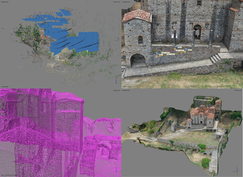
Recommended by Jitte Waagen based on reviews by Nikolai Paukkonen and 1 anonymous reviewerThis paper (Panagiotidis et al. 2024) discusses the digital approach to the ‘digital storyline’ of the Monastery of Brontochion of Mystras, Peloponnese, Greece. Using drone and terrestrial photogrammetric recording techniques, their goal is to produce maps and 3D models that will be integrated in the overall study of the medieval city, as well as function as a comprehensive visualisation of the archaeological site throughout its history. This will take shape as a web application using ArcGIS Online that will be a valuable platform presenting interactive visual information to accompany written publications. In addition, the assets in the database will be available for further advanced purposes, such as suggested by the authors; xR applications, educational games or digital smart guides. The authors of the paper do a good job in describing the historical background of the site and the purpose of the digital documentation techniques, and the applied methods and the technical details of the produced models are dealt with in detail.
The paper presents a compelling case for an integrative approach to using digital recording techniques at an architectonically complex site for Cultural Heritage Management. It can be placed in a series of studies discussing how monumental sites can benefit from advanced digital recording techniques such as those presented in this paper (see for example Waagen and Wijngaarden 2024). The paper is recommended as an interesting read for all who are involved in this field.
References
Panagiotidis V. Vayia, Valantou Vasiliki, Kazolias Anastasios, and Zacharias Nikolaos. (2024). At the Edge of a City: The Digital Storyline of the Brontochion Monastery of Mystras. Zenodo, 8126952, ver. 3 peer-reviewed and recommended by Peer Community in Archaeology. https://doi.org/10.5281/zenodo.8126952
Waagen, J., and van Wijngaarden, G. J. (2024). Understanding Archaeological Site Topography: 3D Archaeology of Archaeology. Journal of Computer Applications in Archaeology, 7(1), 237–243. https://doi.org/10.5334/jcaa.157

Survey Planning, Allocation, Costing and Evaluation (SPACE) Project: Developing a Tool to Help Archaeologists Conduct More Effective Surveys
A new tool to increase the robustness of archaeological field survey
Recommended by Jitte Waagen based on reviews by Philip Verhagen and Tymon de HaasThis well-written and interesting paper ‘Survey Planning, Allocation, Costing and Evaluation (SPACE) Project: Developing a Tool to Help Archaeologists Conduct More Effective Surveys’ deals with the development of a ‘modular, accessible, and simple web-based platform for survey planning and quality assurance’ in the area of pedestrian field survey methods (Banning et al. 2024).
Although there have been excellent treatments of statistics in archaeological field survey (among which various by the first author: Banning 2020, 2021), and there is continuous methodological debate on platforms such as the International Mediterranean Survey Workshop (IMSW), in papers dealing with the current development and state of the field (Knodell et al. 2023), good practices (Attema et al. 2020) or the merits of a quantifying approach to archaeological densities (cf. de Haas et al. 2023), this paper rightfully addresses the lack of rigorous statistical approaches in archaeological field survey. As argued by several scholars such as Orton (2000), this mainly appears the result of lack of knowledge/familiarity/resources to bring in the required expertise etc. with the application of seemingly intricate statistics (cf. Waagen 2022). In this context this paper presents a welcome contribution to the feasibility of a robust archaeological field survey design.
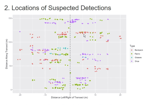
The SPACE application, under development by the authors, is introduced in this paper. It is a software tool that aims to provide different modules to assist archaeologists to make calculations for sample size, coverage, stratification, etc. under the conditions of survey goals and available resources. In the end, the goal is to ensure archaeological field surveys will attain their objectives effectively and permit more confidence in the eventual outcomes. The module concerning Sweep Widths, an issue introduced by the main author in 2006 (Banning 2006) is finished; the sweep width assessment is a methodology to calibrate one’s survey project for artefact types, landscape, visibility and person-bound performance, eventually increasing the quality (comparability) of the collected samples. This is by now a well-known calibration technique, yet little used, so this effort to make that more accessible is certainly laudable. An excellent idea, and another aim of this project, is indeed to build up a database with calibration data, so applying sweep-width corrections will become easier accessible to practitioners who lack time to set up calibration exercises.
It will be very interesting to have a closer look at the eventual platform and to see if, and how, it will be adapted by the larger archaeological field survey community, both from an academic research perspective as from a heritage management point of view. I happily recommend this paper and all debate relating to it, including the excellent peer reviews of the manuscript by Philip Verhagen and Tymon de Haas (available as part of this PCI recommendation procedure), to any practitioner of archaeological field survey.
References
Attema, P., Bintliff, J., Van Leusen, P.M., Bes, P., de Haas, T., Donev, D., Jongman, W., Kaptijn, E., Mayoral, V., Menchelli, S., Pasquinucci, M., Rosen, S., García Sánchez, J., Luis Gutierrez Soler, L., Stone, D., Tol, G., Vermeulen, F., and Vionis. A. 2020. “A guide to good practice in Mediterranean surface survey projects”, Journal of Greek Archaeology 5, 1–62. https://doi.org/10.32028/9781789697926-2
Banning, E.B., Alicia L. Hawkins, S.T. Stewart, Sweep widths and the detection of artifacts in archaeological survey, Journal of Archaeological Science, Volume 38, Issue 12, 2011, Pages 3447-3458. https://doi.org/10.1016/j.jas.2011.08.007
Banning, E.B. 2020. Spatial Sampling. In: Gillings, M., Hacıgüzeller, P., Lock, G. (eds.) Archaeological Spatial Analysis. A Methodological Guide. Routledge.
Banning, E.B. 2021. Sampled to Death? The Rise and Fall of Probability Sampling in Archaeology. American Antiquity, 86(1), 43-60. https://doi.org/10.1017/aaq.2020.39
Banning, E. B. Steven Edwards, & Isaac Ullah. (2024). Survey Planning, Allocation, Costing and Evaluation (SPACE) Project: Developing a Tool to Help Archaeologists Conduct More Effective Surveys. Zenodo, 8072178, ver. 9 peer-reviewed and recommended by Peer Community in Archaeology. https://doi.org/10.5281/zenodo.8072178
Knodell, A.R., Wilkinson, T.C., Leppard, T.P. et al. 2023. Survey Archaeology in the Mediterranean World: Regional Traditions and Contributions to Long-Term History. J Archaeol Res 31, 263–329 (2023). https://doi.org/10.1007/s10814-022-09175-7
Orton, C. 2000. Sampling in Archaeology. Cambridge University Press. https://doi.org/10.1017/CBO9781139163996
Waagen, J. 2022. Sampling past landscapes. Methodological inquiries into the bias problems of recording archaeological surface assemblages. PhD-Thesis. https://hdl.handle.net/11245.1/e9cb922c-c7e4-40a1-b648-7b8065c46880
de Haas, T., Leppard, T. P., Waagen, J., & Wilkinson, T. (2023). Myopic Misunderstandings? A Reply to Meyer (JMA 35(2), 2022). Journal of Mediterranean Archaeology, 36(1), 127-137. https://doi.org/10.1558/jma.27148

Implementing Digital Documentation Techniques for Archaeological Artifacts to Develop a Virtual Exhibition: the Necropolis of Baley Collection
Out of the storeroom and into the virtual
Recommended by Jitte Waagen based on reviews by Alicia Walsh and 1 anonymous reviewerThis paper (Raykovska et al. 2023) discusses the digital documentation techniques and development of a virtual exhibition for artefacts retrieved from the necropolis of Baley, Bulgaria. The principal aim of this particular project is a solid one, trying to provide a solution to display artefacts that would otherwise remain hidden in museum storerooms. The paper describes how through a combination of 3D scanning and photogrammetry high quality 3D models have been produced, and provide content for an online virtual exhibition for the scientific community but also the larger public. It is a well-written and concise paper, in which the information on developed methods and techniques are transparently described, and various important aspects of digitization workflows, such as the importance of storing raw data, are addressed.
The paper is a timely discussion on this subject, as strategies to develop digital artefact collections and what to do with those are increasingly being researched. Specifically, it discusses a workflow and its results, both in great detail. Although critical reflection on the process, goals and results from various perspectives would have been a valuable addition to the paper (cf., Jeffra 2020, Paardekoper 2019), it nonetheless provides a good practice example of how to approach the creation of a virtual museum. Those who consider projects concerning digital documentation of archaeological artefacts as well as the creation of virtual spaces to use those in for research, education or valorisation purposes would do well to read this paper carefully.
References
Jeffra, C., Hilditch, J., Waagen, J., Lanjouw, T., Stoffer, M., de Gelder, L., and Kim, M. J. (2020). Blending the Material and the Digital: A Project at the Intersection of Museum Interpretation, Academic Research, and Experimental Archaeology. The EXARC Journal, 2020(4). https://exarc.net/ark:/88735/10541
Paardekooper, R.P. (2019). Everybody else is doing it, so why can’t we? Low-tech and High-tech approaches in archaeological Open-Air Museums. The EXARC Journal, 2019(4). https://exarc.net/ark:/88735/10457/
Raykovska, M., Jones, K., Klecherova, H., Alexandrov, S., Petkov, N., Hristova, T., and Ivanov, G. (2023). Implementing Digital Documentation Techniques for Archaeological Artifacts to Develop a Virtual Exhibition: the Necropolis of Baley Collection. https://doi.org/10.5281/zenodo.10091870
Review: 1

Underwater Drones as a Low-Cost, yet Powerful Tool for Underwater Archaeological Mapping: Case Studies from the Mediterranean
Underwater drones and semi-automatic SfM, a challenge for underwater archaeology, or are we already there?
Recommended by Jesus Garcia Sanchez based on reviews by Jitte Waagen and 1 anonymous reviewerAnything related to underwater archaeology, either survey, excavation, or documentation processes, poses important challenges that were already once tackled and overcome in ground archaeology. While the archaeological and historical goals of researching the underwater heritage have already been defined and studied in the last decades, i.e. maritime economy, archaeology of harbour constructions, or life within ancient vessels, some of the methodological aspects that we consider normal in the surface are still a matter of concern for underwater archaeologists. Most of these issues are related to a general question: how to acquire geospatial data below the surface. That question related to the problem of acquiring spatial data with GPS data that could be analysed through established tools such as GIS. One could get spatial data with relative positions. However, it has to be inserted in a GIS using a projection.
Drones and GPS are one of the most significant archaeological documentation advances in the last decades. Both systems have become available due to the popularisation of affordable systems and software and the widespread use of GPS for civil uses. Recently, different scholars (Campana, 2017; Stek, 2016; Verhoeven et al., 2021; Waagen, 2019) have elaborated on the use of drones in (Mediterranean) archaeology and beyond. Nevertheless, once one starts working in a completely different setting as underwater archaeology, the need to answer the same methodological questions emerges one more time. How to create digital models of the (sea bottom) surface that could be useful to answer archaeological questions? Those questions could be posed in intra-site contexts (shipwrecks) of “submerged landscape” contexts, like a harbour context, an anchorage area, or a bay used through the past due to favourable conditions.
The paper by Diamanti and colleagues (2024) tackles these issues related to drone-based SfM in underwater archaeology. First, they introduced, albeit generally, drone imagery in archaeology to jump into the evolution of drone technology and its applications to marine archaeology. In this section, the main issues regarding the application of drones underwater are familiar to drone practitioners, such as payload capacity, portability, or affordability; other problems are mostly related to underwater devices, such as dive keep, real-time assessment or positioning using USBL (Ultra short baseline).
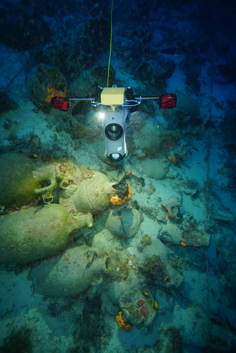
Diamanti and colleagues present two study cases stemming from an ongoing project conducted in the Phournoi archipelago in the North Aegean Sea, Greece. The first study case is a Late Roman/ Early Byzantine shipwreck, and the second case study is an anchorage area. Both cases are relevant to the paper's overall scope and fit the reader's interest in how to apply underwater drone archaeology in a site context, the shipwreck, and in a broad context/ landscape, the anchorage point. The former a fascinating topic that has been tackled systematically in other areas of the Mediterranean sea (Quevedo et al., 2024)
I won’t explain both cases deeply, but both demonstrate the capabilities of drone-based SfM in underwater contexts. The authors use different devices with different cameras and make an interesting comparison with diver-based 3D models, perhaps the most used method to produce orthophotography of the sea-bottom surface for more than half a century (Drap, 2012; Yamafune et al., 2017). The authors lost a good opportunity to present a more exhaustive comparison of dive-based and drone-based SfM results besides the textual explanation. As a reviewer commented a summary table with camera characteristics and data from the processing results could have given way more depth to that interesting analysis. The authors present a workflow of the process when dealing with complex technological elements, starting with the hardware components such as drones, USBL, and cameras, and the software component of the process, from frame extraction to SfM. This addition contributes to the reproducibility of methodologies, as it is expected from methodological paper as this one. Kudos for that.
In general, Diamani et al.'s paper is a valuable contribution to understanding the impact of drone surveys underwater. It offers information about two relevant study cases that could be used as paradigms for upcoming innovation in underwater archaeology. The recommendation remains to elaborate further on the comparative perspective as the only way to make the research truly innovative.
References
Campana, S., 2017. Drones in Archaeology. State-of-the-art and Future Perspectives. Archaeol. Prospect. 24, 275–296. https://doi.org/10.1002/arp.1569
Diamanti, E., Ødegård, Ø., Mentogiannis, V. and Koutsouflakis, G. (2024) Underwater Drones as a Low-Cost, yet Powerful Tool for Underwater Archaeological Mapping: Case Studies from the Mediterranean. Zenodo, ver.3 peer-reviewed and recommended by PCI Archaeology https://doi.org/10.5281/zenodo.13460949
Drap, P., 2012. Underwater Photogrammetry for Archaeology, in: Special Applications of Photogrammetry. IntechOpen. https://doi.org/10.5772/33999
Quevedo, A., Aragón, E., de Dios Hernández García, J., Rodríguez Pandozi, J., Mukai, T., Segura, A., Bellviure, J. and Muñoz Yesares, R., 2024. Isla del Fraile. Reconstructing Coastal Dynamics in Southeastern Spain Through Underwater Archaeological Survey. Archaeol. Prospect. 31, 149–170. https://doi.org/10.1002/arp.1937
Stek, T., 2016. Drones over Mediterranean landscapes. The potential of small UAV’s (drones) for site detection and heritage management in archaeological survey projects: A case study from Le Pianelle in the Tappino Valley, Molise (Italy). J. Cult. Herit. 1066–1071. https://doi.org/10.1016/j.culher.2016.06.006
Verhoeven, G., Cowley, D. and Traviglia, A., 2021. Archaeological Remote Sensing in the 21st Century: (Re)Defining Practice and Theory. https://doi.org/10.3390/books978-3-0365-1376-8
Waagen, J., 2019. New technology and archaeological practice. Improving the primary archaeological recording process in excavation by means of UAS photogrammetry. J. Archaeol. Sci. 101, 11–20. https://doi.org/10.1016/j.jas.2018.10.011
Yamafune, K., Torres, R. and Castro, F., 2017. Multi-Image Photogrammetry to Record and Reconstruct Underwater Shipwreck Sites. J. Archaeol. Method Theory 24, 703–725. https://doi.org/10.1007/s10816-016-9283-1