Latest recommendations

| Id | Title * | Authors * ▲ | Abstract * | Picture * | Thematic fields * | Recommender | Reviewers | Submission date | |
|---|---|---|---|---|---|---|---|---|---|
31 Jan 2024
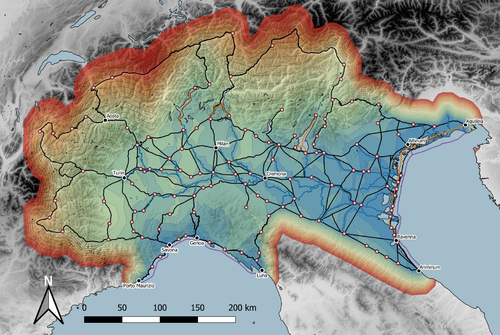
Rivers vs. Roads? A route network model of transport infrastructure in Northern Italy during the Roman periodJames Page https://zenodo.org/records/7971399Modelling Roman Transport Infrastructure in Northern ItalyRecommended by Andrew McLean based on reviews by Pau de Soto and Adam PažoutStudies of the economy of the Roman Empire have become increasingly interdisciplinary and nuanced in recent years, allowing the discipline to make great strides in data collection and importantly in the methods through which this increasing volume of data can be effectively and meaningfully analysed [see for example 1 and 2]. One of the key aspects of modelling the ancient economy is understanding movement and transport costs, and how these facilitated trade, communication and economic development. With archaeologists adopting more computational techniques and utilising GIS analysis beyond simply creating maps for simple visualisation, understanding and modelling the costs of traversing archaeological landscapes has become a much more fruitful avenue of research. Classical archaeologists are often slower to adopt these new computational techniques than others in the discipline. This is despite (or perhaps due to) the huge wealth of data available and the long period of time over which the Roman economy developed, thrived and evolved. This all means that the Roman Empire is a particularly useful proving ground for testing and perfecting new methodological developments, as well as being a particularly informative period of study for understanding ancient human behaviour more broadly. This paper by Page [3] then, is well placed and part of a much needed and growing trend of Roman archaeologists adopting these computational approaches in their research. Page’s methodology builds upon De Soto’s earlier modelling of transport costs [4] and applies it in a new setting. This reflects an important practice which should be more widely adopted in archaeology. That of using existing, well documented methodologies in new contexts to offer wider comparisons. This allows existing methodologies to be perfected and tested more robustly without reinventing the wheel. Page does all this well, and not only builds upon De Soto’s work, but does so using a case study that is particularly interesting with convincing and significant results. As Page highlights, Northern Italy is often thought of as relatively isolated in terms of economic exchange and transport, largely due to the distance from the sea and the barriers posed by the Alps and Apennines. However, in analysing this region, and not taking such presumptions for granted, Page quite convincingly shows that the waterways of the region played an important role in bringing down the cost of transport and allowed the region to be far more interconnected with the wider Roman world than previous studies have assumed. This article is clearly a valuable and important contribution to our understanding of computational methods in archaeology as well as the economy and transport network of the Roman Empire. The article utilises innovative techniques to model transport in an area of the Roman Empire that is often overlooked, with the economic isolation of the area taken for granted. Having high quality research such as this specifically analysing the region using the most current methodologies is of great importance. Furthermore, developing and improving methodologies like this allow for different regions and case studies to be analysed and directly compared, in a way that more traditional analyses simply cannot do. As such, Page has demonstrated the importance of reanalysing traditional assumptions using the new data and analyses now available to archaeologists. References [1] Brughmans, T. and Wilson, A. (eds.) (2022). Simulating Roman Economies: Theories, Methods, and Computational Models. Oxford. [2] Dodd, E.K. and Van Limbergen, D. (eds.) (2024). Methods in Ancient Wine Archaeology: Scientific Approaches in Roman Contexts. London ; New York. [3] Page, J. (2024). Rivers vs. Roads? A route network model of transport infrastructure in Northern Italy during the Roman period, Zenodo, 7971399, ver. 3 peer-reviewed and recommended by Peer Community in Archaeology. https://doi.org/10.5281/zenodo.7971399 [4] De Soto P (2019). Network Analysis to Model and Analyse Roman Transport and Mobility. In: Finding the Limits of the Limes. Modelling Demography, Economy and Transport on the Edge of the Roman Empire. Ed. by Verhagen P, Joyce J, and Groenhuijzen M. Springer Open Access, pp. 271–90. https://doi.org/10.1007/978-3-030-04576-0_13 | Rivers vs. Roads? A route network model of transport infrastructure in Northern Italy during the Roman period | James Page | <p>Northern Italy has often been characterised as an isolated and marginal area during the Roman period, a region constricted by mountain ranges and its distance from major shipping lanes. Historians have frequently cited these obstacles, alongsid... |  | Classic, Computational archaeology | Andrew McLean | 2023-05-28 15:11:31 | View | |
14 Nov 2022
Raphana of the Decapolis and its successor Arpha - The search for an eminent Greco-Roman CityJens Kleb https://doi.org/10.6084/m9.figshare.20550021Cross-comparison of classical sources, explorer and scientific reports and maps in the search of an ancient city: The example of Raphana of the DecapolisRecommended by Luc Doyon based on reviews by Rocco Palermo and Francesca Mazzilli based on reviews by Rocco Palermo and Francesca Mazzilli
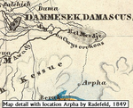
Establishing the precise location of ancient cities constitutes a challenging task that requires the implementation of multi-disciplinary approaches. In his manuscript entitled “Raphana of the Decapolis and its successor Arpha: The search of an eminent Greco-Roman city”, Kleb (2022) proposes a convincing argument building on in-depth research of classical literary sources, literature review of explorer accounts and scientific publications from the 19th and 20th century as well as analysis of old and new maps, aerial photographs, and satellite images. This research report clearly emphasizes the importance of undertaking systematic interdisciplinary work on the topic to mitigate the uncertainties associated with the identification of Raphana, the Decapolis city first mentioned by Pliny the Elder. The Decapolis refers to a group of ten cities of Hellenistic traditions located on the eastern borders of the Roman Empire. This group of cities plays an important role in research that aims to contextualize the Judaean and Galilean history and to investigate urban centers in which different local and Greco-Roman influences met (Lichtenberger, 2021). While the location of most of the Decapolis cities is known and is (or was) subjected to systematic archaeological investigations (e.g., Eisenberg and Kowalewska, 2022; Makhadmeh et al., 2020; Shiyab et al., 2019), the location of others remain speculative. This is the case of Raphana for which the precise location remains difficult to establish owing in part to numerous name changes, limited information on the city structure, architecture, and size, etc. The research presented by Kleb (2022) has some merits, which is emphasized here, although the report is presented in an unusual format compared to traditional scientific articles, i.e., introduction, research background, methodology, results, and discussion. First, the extensive review of classical works allows the reader to gain a historical perspective on the change of names from Raepta/Raphana to Arpha/Arefa. The author argues these different names likely refer to a single location. Second, the author combs through an impressive literature from the 19th and 20th century and emphasize how some assumptions by explorers who visited the region were introduced in the scientific literature and remained unchallenged. Finally, the author gathers a remarkable quantity of old and new maps of the Golan, el-Ledja and Hauran regions and compare them with multiple lines of evidence to hypothesize that the location of Raphana may lie near Ar-Rafi’ah, also known as Bir Qassab, in the Ard el Fanah plain, a conclusion that now requires to be tested through fieldwork investigations. References Kleb, J. (2022) Raphana of the Decapolis and its successor Arpha - The search for an eminent Greco-Roman City. Figshare, 20550021, ver. 4 peer-reviewed and recommended by Peer Community in Archaeology. https://doi.org/10.6084/m9.figshare.20550021 Eisenberg, M. and Kowalewska, A. (2022). Funerary podia of Hippos of the Decapolis and the phenomenon in the Roman world. J. Roman Archaeol. 35, 107–138. https://doi.org/10.1017/S1047759421000465 Lichtenberger, A. (2021). The Decapolis, in: A Companion to the Hellenistic and Roman Near East. John Wiley & Sons, Ltd, pp. 213–222. https://doi.org/10.1002/9781119037354.ch18 Makhadmeh, A., Al-Badarneh, M., Rawashdeh, A. and Al-Shorman, A. (2020). Evaluating the carrying capacity at the archaeological site of Jerash (Gerasa) using mathematical GIS modeling. Egypt. J. Remote Sens. Space Sci. 23, 159–165. https://doi.org/10.1016/j.ejrs.2018.09.002 Shiyab, A., Al-Shorman, A., Turshan, N., Tarboush, M., Alawneh, F. and Rahabneh, A. (2019). Investigation of late Roman pottery from Gadara of the Decapolis, Jordan using multi-methodic approach. J. Archaeol. Sci. Rep. 25, 100–115. https://doi.org/10.1016/j.jasrep.2019.04.003 | Raphana of the Decapolis and its successor Arpha - The search for an eminent Greco-Roman City | Jens Kleb | <p style="text-align: justify;">This research paper presents a detailed analysis of ancient literature and archaeological and geographical research until the present day for an important ancient location in the southern part of Syria. This one had... |  | Landscape archaeology, Mediterranean, Spatial analysis, Theoretical archaeology | Luc Doyon | 2021-12-30 13:54:32 | View | |
26 Mar 2024
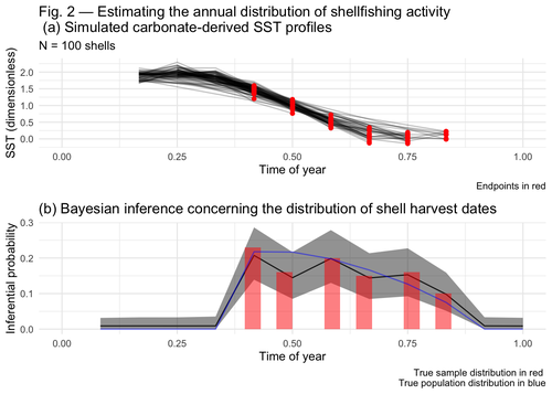
Inferring shellfishing seasonality from the isotopic composition of biogenic carbonate: A Bayesian approachJordan Brown and Gabriel Lewis https://doi.org/10.5281/zenodo.7949547Mixture models and seasonal mobilityRecommended by Alfredo Cortell-Nicolau and Simon Carrignon based on reviews by Iza Romanowska and 1 anonymous reviewerThe paper by Brown & Lewis [1] presents an approach to measure seasonal mobility and subsistence practices. In order to do so, the paper proposes a Bayesian mixture model to estimate the annual distribution of shellfish harvesting activity. Following the recommendations of the two reviewers, the paper presents a clear and innovative method to assess seasonal mobility for prehistoric groups, although it could benefit from additional references regarding isotopic literature. While the adequacy of isotope analysis for estimating mobility patterns in Archaeology has been extensively proven by now, work on specific seasonal mobility is not that much abundant. However, this is a key issue, since seasonal mobility is one of the main social components defining the differences between groups both considering farming vs hunting and gathering or even among hunter-gatherer groups themselves. In this regard, the paper brings a valuable methodological resources that can be used for further research in this issue. One of its greatest values is the fact that it can quantify the uncertainty present in previous isotope studies in seasonal mobility. As stated by the authors, the model can still undergo several optimisation aspects, but as it stands, it is already providing a valuable asset regarding the quantification of uncertainy in the isotopic studies of seasonal mobility. Reference [1] Brown, J. and Lewis, G. (2024). Inferring shellfishing seasonality from the isotopic composition of biogenic carbonate: A Bayesian approach. Zenodo, 7949547, ver. 3 peer-reviewed and recommended by Peer Community in Archaeology. https://doi.org/10.5281/zenodo.7949547 | Inferring shellfishing seasonality from the isotopic composition of biogenic carbonate: A Bayesian approach | Jordan Brown and Gabriel Lewis | <p>The problem of accurately and reliably estimating the annual distribution of seasonally-varying human settlement and subsistence practices is a classic concern among archaeologists, which has only become more relevant with the increasing import... |  | Archaeometry, Computational archaeology, Environmental archaeology, North America, Palaeontology, Paleoenvironment, Zooarchaeology | Alfredo Cortell-Nicolau | Iza Romanowska, Eduardo Herrera Malatesta, Alejandro Sierra Sainz-Aja, Sam Leggett, Christianne Fernee, Anonymous, Asier García-Escárzaga , Paul Szpak , Maria Elena Castiello , Jasmine Lundy , Tansy Branscombe | 2023-10-03 04:45:54 | View |
02 Nov 2020
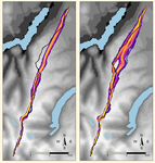
Probabilistic Modelling using Monte Carlo Simulation for Incorporating Uncertainty in Least Cost Path Results: a Roman Road Case StudyJoseph Lewis https://doi.org/10.31235/osf.io/mxas2A probabilistic method for Least Cost Path calculation.Recommended by Otis Crandell based on reviews by Georges Abou Diwan and 1 anonymous reviewerThe paper entitled “Probabilistic Modelling using Monte Carlo Simulation for Incorporating Uncertainty in Least Cost Path Results: a Roman Road Case Study” [1] submitted by J. Lewis presents an innovative approach to applying Least Cost Path (LCP) analysis to incorporate uncertainty of the Digital Elevation Model used as the topographic surface on which the path is calculated. The proposition of using Monte Carlo simulations to produce numerous LCP, each with a slightly different DEM included in the error range of the model, allows one to strengthen the method by proposing a probabilistic LCP rather than a single and arbitrary one which does not take into account the uncertainty of the topographic reconstruction. This new method is integrated in the R package leastcostpath [2]. The author tests the method using a Roman road built along a ridge in Cumbria, England. The integration of the uncertainty of the DEM, thanks to Monte Carlo simulations, shows that two paths could have the same probability to be the real LCP. One of them is indeed the path that the Roman road took. In particular, it is one of two possibilities of LCP in the south to north direction. This new probabilistic method therefore strengthens the reconstruction of past pathways, while also allowing new hypotheses to be tested, and, in this case study, to suggest that the northern part of the Roman road’s location was selected to help the northward movements. [1] Lewis, J., 2020. Probabilistic Modelling using Monte Carlo Simulation for Incorporating Uncertainty in Least Cost Path Results: a Roman Road Case Study. SocArXiv, mxas2, ver 17 peer-reviewed and recommended by PCI Archaeology, 10.31235/osf.io/mxas2. [2] Lewis, J., 2020. leastcostpath: Modelling Pathways and Movement Potential Within a Landscape. R package. Version 1.7.4. | Probabilistic Modelling using Monte Carlo Simulation for Incorporating Uncertainty in Least Cost Path Results: a Roman Road Case Study | Joseph Lewis | <p>The movement of past peoples in the landscape has been studied extensively through the use of Least Cost Path (LCP) analysis. Although methodological issues of applying LCP analysis in Archaeology have frequently been discussed, the effect of v... |  | Spatial analysis | Otis Crandell | Adam Green, Georges Abou Diwan | 2020-08-05 12:10:46 | View |
29 Jan 2024
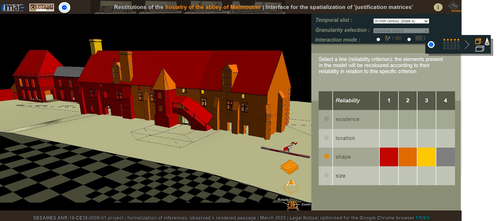
Visual encoding of a 3D virtual reconstruction's scientific justification: feedback from a proof-of-concept researchJ.Y Blaise, I.Dudek, L.Bergerot, G.Simon https://zenodo.org/record/79831633D Models, Knowledge and Visualization: a prototype for 3D virtual models according to plausible criteriaRecommended by Daniel Carvalho based on reviews by Robert Bischoff and Louise TharandtThe construction of 3D realities is deeply embedded in archaeological practices. From sites to artifacts, archaeology has dedicated itself to creating digital copies for the most varied purposes. The paper “Visual encoding of a 3D virtual reconstruction's 3 scientific justification: feedback from a proof-of-concept research” (Jean-Yves et al 2024) represents an advance, in the sense that it does not just deal with a three-dimensional theory for archaeological practice, but rather offers proposals regarding the epistemic component, how it is possible to represent knowledge through the workflow of 3D virtual reconstructions themselves. The authors aim to unite three main axes - knowledge modeling, visual encoding and 3D content reuse - (Jean-Yves et al 2024: 2), which, for all intents and purposes, form the basis of this article. With regard to the first aspect, this work questions how it is possible to transmit the knowledge we want to a 3D model and how we can optimize this epistemic component. A methodology based on plausibility criteria is offered, which, for the archaeological field, offers relevant space for reflection. Given our inability to fully understand the object or site that is the subject of the 3D representation, whether in space or time, building a method based on probabilistic categories is probably one of the most realistic approaches to the realities of the past. Thus, establishing a plausibility criterion allows the user to question the knowledge that is transmitted through the representation, and can corroborate or refute it in future situations. This is because the role of reusing these models is of great interest to the authors, a perfectly justifiable sentiment, as it encourages a critical view of scientific practices. Visual encoding is, in terms of its conjunction with knowledge practices, a key element. The notion of simplicity under Maeda's (2006) design principles not only represents a way of thinking that favors operability, but also a user-friendly design in the prototype that the authors have created. This is also visible when it comes to the reuse of parts of the models, in a chronological logic: adapting the models based on architectural elements that can be removed or molded is a testament to intelligent design, whereby instead of redoing models in their entirety, they are partially used for other purposes. All these factors come together in the final prototype, a web application that combines relational databases (RDBMS) with a data mapper (MassiveJS), using the PHP programming language. The example used is the Marmoutier Abbey hostelry, a centuries-old building which, according to the sources presented, has evolved architecturally over several centuries ((Jean-Yves et al 2024: 8). These states of the building are represented visually through architectural elements based on their existence, location, shape and size, always in terms of what is presented as being plausible. This allows not only the creation of a matrix in which various categories are related to various architectural elements, but also a visual aid, through a chromatic spectrum, of the plausibility that the authors are aiming for. In short, this is an article that seeks to rethink the degree of knowledge we can obtain through 3D visualizations and that does not take models as static, but rather realities that must be explored, recycled and reinterpreted in the light of different data, users and future research. For this reason, it is a work of great relevance to theoretical advances in 3D modeling adapted to archaeology.
References Blaise, J.-Y., Dudek, I., Bergerot, L. and Gaël, S. (2024). Visual encoding of a 3D virtual reconstruction's scientific justification: feedback from a proof-of-concept research, Zenodo, 7983163, ver. 3 peer-reviewed and recommended by Peer Community in Archaeology. https://doi.org/10.5281/zenodo.10496540 John Maeda. (2006). The Laws of Simplicity. MIT Press, Cambridge, MA, USA. | Visual encoding of a 3D virtual reconstruction's scientific justification: feedback from a proof-of-concept research | J.Y Blaise, I.Dudek, L.Bergerot, G.Simon | <p> 3D virtual reconstructions have become over the last decades a classical mean to communicate about analysts’ visions concerning past stages of development of an edifice or a site. However, they still today remain quite often a one-s... |  | Computational archaeology, Spatial analysis | Daniel Carvalho | 2023-05-30 00:43:03 | View | |
04 Jul 2024
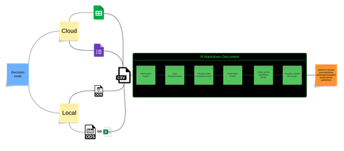
An approach to establishing a workflow pipeline for synergistic analysis of osteological and biochemical data. The case study of Amvrakia in the context of Corinthian colonisation between 625-189 BC in Epirus, Greece.Kiriakos Xanthopoulos, Angeliki Georgiadou, Christina Papageorgopoulou https://doi.org/10.5281/zenodo.8298579Establishing a workflow for recording and analysing bioarchaeological dataRecommended by Christianne Fernee based on reviews by 2 anonymous reviewersThe paper by Xanthopoulos and colleagues [1] presents an approach to establish a pipeline for the analysis of osteological and biochemical data. This approach integrates novel data collection, FAIR principles for data longevity and accessibility, utilises R markdown and cloud webware. Following the changes recommended by the reviewers this paper presents a welcome contribution to osteoarcheology and bioarchaeology. Osteoarchaeology and bioarchaeology often involves the collection of vast amounts of data both in the field and from consequential analysis in the lab. From this data we can reconstruct many aspects of past human experiences. However, issues often arise when bringing together these diverse types of data. In this regard, this paper proposes are useful methodology in which osteoarchaeological researchers can bring their data together as part of a streamlined process, from data collection to analyses.
References [1] Xanthopoulos, K., Georgiadou, A. and Papageorgopoulou, C. (2024). An approach to establishing a workflow pipeline for synergistic analysis of osteological and biochemical data. The case study of Amvrakia in the context of Corinthian colonisation between 625-189 BC in Epirus, Greece. Zenodo, 11156506, ver. 3 peer-reviewed and recommended by Peer Community in Archaeology. https://doi.org/10.5281/zenodo.8298579 | An approach to establishing a workflow pipeline for synergistic analysis of osteological and biochemical data. The case study of Amvrakia in the context of Corinthian colonisation between 625-189 BC in Epirus, Greece. | Kiriakos Xanthopoulos, Angeliki Georgiadou, Christina Papageorgopoulou | <p>Bioarchaeology has long focused on understanding past human life through skeletal remains, including oral pathology and stable isotope analysis. Despite advancements in statistical analysis, correlations are still largely made manually. To stre... |  | Antiquity, Bioarchaeology, Computational archaeology, Conservation/Museum studies, Mediterranean, Physical anthropology | Christianne Fernee | 2023-08-30 14:01:44 | View | |
14 Mar 2024
How FAIR is Bioarchaeological Data: with a particular emphasis on making archaeological science data ReusableLien-Talks, Alphaeus https://doi.org/10.5281/zenodo.8139910FAIR data in bioarchaeology - where are we at?Recommended by Claudia Speciale based on reviews by Emma Karoune, Jan Kolar and 2 anonymous reviewers based on reviews by Emma Karoune, Jan Kolar and 2 anonymous reviewers
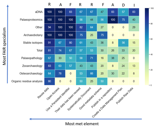
The increasing reliance on digital and big data in archaeology is pushing the scientific community more and more to reconsider their storing and use [1, 2]. Furthermore, the openness and findability in the way these data are shared represent a key matter for the growth of the discipline, especially in the case of bioarchaeology and archaeological sciences [3]. In this paper, [4] the author presents the result of a survey targeted on UK bioarchaeologists and then extended worldwide. The paper maintains the structure of a report as it was intended for the conference it was part of (CAA 2023, Amsterdam) but it represents the first public outcome of an inquiry on the bioarchaeological scientific community. A reflection on ourselves and our own practices. Are all the disciplines adhering to the same policies? Do any bioarchaeologist use the same protocols and formats? Are there any differences in between the domains? Is the Needs Analysis fulfilling the questions? The results, obtained through an accurate screening to avoid distortions, are creating an intriguing picture on the current state of "fairness" and highlighting how Institutions' rules and policies can and should indicate the correct workflow to follow. In the end, the wide application of the FAIR principles will contribute significantly to the growth of the disciplines and to create an environment where the users are not just contributors, but primary beneficiaries of the system. [1] Huggett j. (2020). Is Big Digital Data Different? Towards a New Archaeological Paradigm, Journal of Field Archaeology, 45:sup1, S8-S17. https://doi.org/10.1080/00934690.2020.1713281 [2] Nicholson C., Kansa S., Gupta N. and Fernandez R. (2023). Will It Ever Be FAIR?: Making Archaeological Data Findable, Accessible, Interoperable, and Reusable. Advances in Archaeological Practice 11 (1): 63-75. https://doi.org/10.1017/aap.2022.40 [3] Plomp E., Stantis C., James H.F., Cheung C., Snoeck C., Kootker L., Kharobi A., Borges C., Reynaga D.K.M., Pospieszny Ł., Fulminante, F., Stevens, R., Alaica, A. K., Becker, A., de Rochefort, X. and Salesse, K. (2022). The IsoArcH initiative: Working towards an open and collaborative isotope data culture in bioarchaeology. Data in brief, 45, p.108595. https://doi.org/10.1016/j.dib.2022.108595 [4] Lien-Talks, A. (2024). How FAIR is Bioarchaeological Data: with a particular emphasis on making archaeological science data Reusable. Zenodo, 8139910, ver. 6 peer-reviewed and recommended by Peer Community in Archaeology. https://doi.org/10.5281/zenodo.8139910 | How FAIR is Bioarchaeological Data: with a particular emphasis on making archaeological science data Reusable | Lien-Talks, Alphaeus | <p>Bioarchaeology, which encompasses the study of ancient DNA, osteoarchaeology, paleopathology, palaeoproteomics, stable isotopes, and zooarchaeology, is generating an ever-increasing volume of data as a result of advancements in molecular biolog... |  | Bioarchaeology, Computational archaeology, Zooarchaeology | Claudia Speciale | 2023-07-12 19:12:44 | View | |
08 Feb 2021
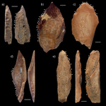
A 115,000-year-old expedient bone technology at Lingjing, Henan, ChinaLuc Doyon, Zhanyang Li, Hua Wang, Lila Geis, Francesco d’Errico https://doi.org/10.31235/osf.io/68xpzA step towards the challenging recognition of expedient bone toolsRecommended by Camille Daujeard based on reviews by Delphine Vettese, Jarod Hutson and 1 anonymous reviewerThis article by L. Doyon et al. [1] represents an important step to the recognition of bone expedient tools within archaeological faunal assemblages, and therefore deserves publication. In this work, the authors compare bone flakes and splinters experimentally obtained by percussion (hammerstone and anvil technique) with fossil ones coming from the Palaeolithic site of Lingjing in China. Their aim is to find some particularities to help distinguish the fossil bone fragments which were intentionally shaped, from others that result notably from marrow extraction. The presence of numerous (>6) contiguous flake scars and of a continuous size gradient between the lithics and the bone blanks used, appear to be two valuable criteria for identifying 56 bone elements of Lingjing as expedient bone tools. The latter are present alongside other bone tools used as retouchers [2]. Another important point underlined by this study is the co-occurrence of impact and flake scars among the experimentally broken specimens (~90%), while this association is seldom observed on archaeological ones. Thus, according to the authors, a low percentage of that co-occurrence could be also considered as a good indicator of the presence of intentionally shaped bone blanks. About the function of these expedient bone tools, the authors hypothesize that they were used for in situ butchering activities. However, future experimental investigations on this question of the function of these tools are expected, including an experimental use wear program. Finally, highlighting the presence of such a bone industry is of importance for a better understanding of the adaptive capacities and cultural practices of the past hominins. This work therefore invites all taphonomists to pay more attention to flake removal scars on bone elements, keeping in mind the possible existence of that type of bone tools. In fact, being able to distinguish between bone fragments due to marrow recovery and bone tools is still a persistent and important issue for all of us, but one that deserves great caution. [1] Doyon, L., Li, Z., Wang, H., Geis, L. and d'Errico, F. 2021. A 115,000-year-old expedient bone technology at Lingjing, Henan, China. Socarxiv, 68xpz, ver. 4 peer-reviewed and recommended by PCI Archaeology. https://doi.org/10.31235/osf.io/68xpz [2] Doyon, L., Li, Z., Li, H., and d’Errico, F. 2018. Discovery of circa 115,000-year-old bone retouchers at Lingjing, Henan, China. Plos one, 13(3), https://doi.org/10.1371/journal.pone.0194318. | A 115,000-year-old expedient bone technology at Lingjing, Henan, China | Luc Doyon, Zhanyang Li, Hua Wang, Lila Geis, Francesco d’Errico | <p>Activities attested since at least 2.6 Myr, such as stone knapping, marrow extraction, and woodworking may have allowed early hominins to recognize the technological potential of discarded skeletal remains and equipped them with a transferable ... |  | Asia, Middle Palaeolithic, Osseous industry, Taphonomy, Zooarchaeology | Camille Daujeard | 2020-11-01 11:09:13 | View | |
26 Oct 2022
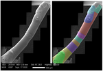
Technological analysis and experimental reproduction of the techniques of perforation of quartz beads from the Ceramic period in the AntillesMadeleine Raymond, Pierrick Fouéré, Ronan Ledevin, Yannick Lefrais and Alain Queffelec https://osf.io/preprints/socarxiv/a5tgpUsing Cactus Thorns to Drill Quartz: A Proof of ConceptRecommended by Donatella Usai and Jonathan Hanna based on reviews by Viola Stefano, ? and 1 anonymous reviewer based on reviews by Viola Stefano, ? and 1 anonymous reviewer
Quartz adornments (beads, pendants, etc.) are frequent artifacts found in the Caribbean, particularly from Early Ceramic Age contexts (~500 BC-AD 700). As a form of specialization, these are sometimes seen as indicative of greater social complexity and craftsmanship during this time. Indeed, ethnographic analogy has purported that such stone adornments require enormous inputs of time and labor, as well as some technological sophistication with tools hard-enough to create the holes (e.g., metal or diamonds). However, given these limitations, one would expect unfinished beads to be a common artifact in the archaeological record. Yet, whereas unworked/raw materials are often found, beads with partial/unfinished perforations are not. References:
| Technological analysis and experimental reproduction of the techniques of perforation of quartz beads from the Ceramic period in the Antilles | Madeleine Raymond, Pierrick Fouéré, Ronan Ledevin, Yannick Lefrais and Alain Queffelec | <p style="text-align: justify;">Personal ornaments are a very specific kind of material production in human societies and are particularly valuable artifacts for the archaeologist seeking to understand past societies. In the Caribbean, Early Ceram... |  | Lithic technology, Neolithic, South America, Symbolic behaviours, Traceology | Donatella Usai | 2022-09-06 14:01:51 | View | |
03 Nov 2023
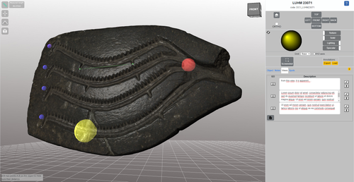
The Dynamic Collections – a 3D Web Platform of Archaeological Artefacts designed for Data Reuse and Deep InteractionMarco Callieri, Åsa Berggren, Nicolò Dell’Unto, Paola Derudas, Domenica Dininno, Fredrik Ekengren, Giuseppe Naponiello https://doi.org/10.5281/zenodo.10067103A comparative teaching and learning tool for 3D data: Dynamic CollectionsRecommended by Sebastian Hageneuer based on reviews by Alex Brandsen and Louise Tharandt based on reviews by Alex Brandsen and Louise Tharandt
The paper (Callieri, M. et al. 2023) describes the “Dynamic Collections” project, an online platform initially created to showcase digital archaeological collections of Lund University. During a phase of testing by department members, new functionalities and artefacts were added resulting in an interactive platform adapted to university-level teaching and learning. The paper introduces into the topic and related works after which it starts to explain the project itself. The idea is to resemble the possibilities of interaction of non-digital collections in an online platform. Besides the objects themselves, the online platform offers annotations, measurement and other interactive tools based on the already known 3DHOP framework. With the possibility to create custom online collections a collaborative working/teaching environment can be created. The already wide-spread use of the 3DHOP framework enabled the authors to develop some functionalities that could be used in the “Dynamic Collections” project. Also, current and future plans of the project are discussed and will include multiple 3D models for one object or permanent identifiers, which are both important additions to the system. The paper then continues to explain some of its further planned improvements, like comparisons and support for teaching, which will make the tool an important asset for future university-level education. The paper in general is well-written and informative and introduces into the interactive tool, that is already available and working. It is very positive, that the authors rely on up-to-date methodologies in creating 3D online repositories and are in fact improving them by testing the tool in a teaching environment. They mention several times the alignment with upcoming EU efforts related to the European Collaborative Cloud for Cultural Heritage (ECCCH), which is anticipatory and far-sighted and adds to the longevity of the project. Comments of the reviewers were reasonably implemented and led to a clearer and more concise paper. I am very confident that this tool will find good use in heritage research and presentation as well as in university-level teaching and learning. Although the authors never answer the introductory question explicitly (What characteristics should a virtual environment have in order to trigger dynamic interaction?), the paper gives the implicit answer by showing what the "Dynamic Collections" project has achieved and is able to achieve in the future. BibliographyCallieri, M., Berggren, Å., Dell'Unto, N., Derudas, P., Dininno, D., Ekengren, F., and Naponiello, G. (2023). The Dynamic Collections – a 3D Web Platform of Archaeological Artefacts designed for Data Reuse and Deep Interaction, Zenodo, 10067103, ver. 3 peer-reviewed and recommended by Peer Community in Archaeology. https://doi.org/10.5281/zenodo.10067103 | The Dynamic Collections – a 3D Web Platform of Archaeological Artefacts designed for Data Reuse and Deep Interaction | Marco Callieri, Åsa Berggren, Nicolò Dell’Unto, Paola Derudas, Domenica Dininno, Fredrik Ekengren, Giuseppe Naponiello | <p>The Dynamic Collections project is an ongoing initiative pursued by the Visual Computing Lab ISTI-CNR in Italy and the Lund University Digital Archaeology Laboratory-DARKLab, Sweden. The aim of this project is to explore the possibilities offer... |  | Archaeometry, Computational archaeology | Sebastian Hageneuer | 2023-08-31 15:05:32 | View |
MANAGING BOARD
Alain Queffelec
Marta Arzarello
Ruth Blasco
Otis Crandell
Luc Doyon
Sian Halcrow
Emma Karoune
Aitor Ruiz-Redondo
Philip Van Peer


