Latest recommendations

| Id | Title * | Authors * | Abstract * | Picture * | Thematic fields * | Recommender▲ | Reviewers | Submission date | |
|---|---|---|---|---|---|---|---|---|---|
26 Oct 2022
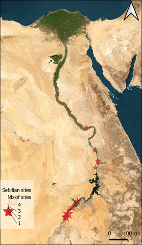
Technological analysis and experimental reproduction of the techniques of perforation of quartz beads from the Ceramic period in the AntillesUsing Cactus Thorns to Drill Quartz: A Proof of ConceptRecommended by Donatella Usai and Jonathan Hanna based on reviews by Viola Stefano, ? and 1 anonymous reviewer based on reviews by Viola Stefano, ? and 1 anonymous reviewer
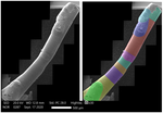
Quartz adornments (beads, pendants, etc.) are frequent artifacts found in the Caribbean, particularly from Early Ceramic Age contexts (~500 BC-AD 700). As a form of specialization, these are sometimes seen as indicative of greater social complexity and craftsmanship during this time. Indeed, ethnographic analogy has purported that such stone adornments require enormous inputs of time and labor, as well as some technological sophistication with tools hard-enough to create the holes (e.g., metal or diamonds). However, given these limitations, one would expect unfinished beads to be a common artifact in the archaeological record. Yet, whereas unworked/raw materials are often found, beads with partial/unfinished perforations are not. References:
| Technological analysis and experimental reproduction of the techniques of perforation of quartz beads from the Ceramic period in the Antilles | Madeleine Raymond, Pierrick Fouéré, Ronan Ledevin, Yannick Lefrais and Alain Queffelec | <p style="text-align: justify;">Personal ornaments are a very specific kind of material production in human societies and are particularly valuable artifacts for the archaeologist seeking to understand past societies. In the Caribbean, Early Ceram... | | Lithic technology, Neolithic, South America, Symbolic behaviours, Traceology | Donatella Usai | 2022-09-06 14:01:51 | ||
25 Jul 2023
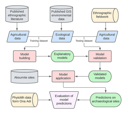
Sorghum and finger millet cultivation during the Aksumite period: insights from ethnoarchaeological modelling and microbotanical analysisAn innovative integration of ethnoarchaeological models with phytolith data to study histories of C4 crop cultivationRecommended by Emma Loftus based on reviews by Tanya Hattingh and 1 anonymous reviewerThis article “Sorghum and finger millet cultivation during the Aksumite period: insights from ethnoarchaeological modelling and microbotanical analysis”, submitted by Ruiz-Giralt and colleagues (2023a), presents an innovative attempt to address the lack of palaeobotanical data concerning ancient agricultural strategies in the northern Horn of Africa. In lieu of well-preserved macrobotanical remains, an especial problem for C4 crop species, these authors leverage microbotanical remains (phytoliths), in combination with ethnoarchaeologically-informed agroecology models to investigate finger millet and sorghum cultivation during the period of the Aksumite Kingdom (c. 50 BCE – 800 CE). Both finger millet and sorghum have played important roles in the subsistence of the Horn region, and throughout much of the rest of Africa and the world in the past. The importance of these drought-resistant and adaptable crops is likely to increase as we move into a warmer, drier world. Yet their histories of cultivation are still only approximately sketched due to a paucity of well-preserved remains from archaeological sites - for example, debate continues as to the precise centre of their domestication. Recent studies of phytoliths (by these and other authors) are demonstrating the likely continuous presence of these crops from the pre-Aksumite period. However, phytoliths are diagnostic only to broad taxonomic levels, and cannot be used to securely identify species. To supplement these observations, Ruiz-Giralt et al. deploy models (previously developed by this team: Ruiz-Giralt et al., 2023b) that incorporate environmental variables and ethnographic data on traditional agrosystems. They evaluate the feasibility of different agricultural regimes around the locations of numerous archaeological sites distributed across the highlands of northern Ethiopia and southern Eritrea. Their results indicate the general viability of finger millet and sorghum cultivation around archaeological settlements in the past, with various regions displaying greater-or-lesser suitability at different distances from the site itself. The models also highlight the likelihood of farmers utilising extensive-rainfed regimes, given low water and soil nutrient requirements for these crops. The authors discuss the results with respect to data on phytolith assemblages, particularly at the site of Ona Adi. They conclude that Aksumite agriculture very likely included the cultivation of finger millet and sorghum, as part of a broader system of rainfed cereal cultivation. Ruiz-Giralt et al. argue, and have demonstrated, that ethnoarchaeologically-informed models can be used to generate hypotheses to be evaluated against archaeological data. The integration of many diverse lines of information in this paper certainly enriches the discussion of agricultural possibilities in the past, and the use of a modelling framework helps to formalise the available hypotheses. However, they emphasise that modelling approaches cannot be pursued in lieu of rigorous archaeobotanical studies but only in tandem - a greater commitment to archaeobotanical sampling is required in the region if we are to fully detail the histories of these important crops. References Ruiz-Giralt, A., Beldados, A., Biagetti, S., D’Agostini, F., D’Andrea, A. C., Meresa, Y. and Lancelotti, C. (2023a). Sorghum and finger millet cultivation during the Aksumite period: insights from ethnoarchaeological modelling and microbotanical analysis. Zenodo, 7859673, ver. 3 peer-reviewed and recommended by Peer Community in Archaeology. https://doi.org/10.5281/zenodo.7859673 Ruiz-Giralt, A., Biagetti, S., Madella, M. and Lancelotti, C. (2023b). Small-scale farming in drylands: New models for resilient practices of millet and sorghum cultivation. PLoS ONE 18, e0268120. https://doi.org/10.1371/journal.pone.0268120
| Sorghum and finger millet cultivation during the Aksumite period: insights from ethnoarchaeological modelling and microbotanical analysis | Abel Ruiz-Giralt, Alemseged Beldados, Stefano Biagetti, Francesca D’Agostini, A. Catherine D’Andrea, Yemane Meresa, Carla Lancelotti | <p>For centuries, finger millet (<em>Eleusine coracana</em> Gaertn.) and sorghum (<em>Sorghum bicolor</em> (L.) Moench) have been two of the most economically important staple crops in the northern Horn of Africa. Nonetheless, their agricultural h... | | Africa, Archaeobotany, Computational archaeology, Protohistory, Spatial analysis | Emma Loftus | 2023-04-29 16:24:54 | ||
20 Jun 2020
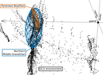
Investigating relationships between technological variability and ecology in the Middle Gravettian (ca. 32-28 ka cal. BP) in France.Understanding Palaeolithic adaptations through niche modelling - the case of the French Middle GravettianRecommended by Felix Riede based on reviews by Andreas Maier and João MarreirosThe paper entitled “Investigating relationships between technological variability and ecology in the Middle Gravettian (ca. 32-28 ky cal. BP) in France” [1] submitted by A. Vignoles and colleagues offers a robust and interesting new analysis of the niche differences between the Rayssian and Noaillian facies of the Middle Gravettian in France. Understanding technological variability in the Palaeolithic is a long-standing challenge. Previous debates have vacillated between strong, quasi-ethnic culture-historical interpretations rooted in the traditional European school and extreme functional stances that would see artefact forms and their frequencies with assemblages conditioned by site function. While both positions have their merits, many empirical and conceptual caveats haunt them equally [see 2]. In this new study Vignoles and colleagues, so-called eco-cultural niche modelling is applied in an attempt to explore whether, and if so, which environmental background factors may have conditioned the emergence and persistence of two sub-cultural categories (facies) within the Middle Gravettian: the Rayssian and the Noaillian. These are are defined through, respectively, a specific knapping method and the presence of a specific burin type, and the occurrence of these seems divided by the Garonne River. Eco-cultural niche modelling has emerged as an archaeological application of distribution models widely employed in ecology, including palaeoecology, to understand organismal niche envelopes [3]. They constitute powerful tools for using the spatial and chronological information inherent in the archaeological record to up-scale interpretations of human-environment relations beyond individual site stratigraphies or dating series. Another important feature of such models is that their performance can, as Vignoles et al. also show, be formally evaluated and replicated. Following on from earlier applications of such techniques [e.g. 4], the authors here present an interesting study that uses very specific archaeological indicators – namely the Raysse method and the Noaillian burin – as defining features for the units (communities, traditions) whose adaptations they investigate. While broad tool types have previously been used as cultural taxonomic indicators in niche modelling studies [5], the present study is ambitious in its attempt to understand variability at a relatively small spatial scale. This mirrors equally interesting attempts of doing so in later prehistoric contexts [6]. Applications of niche modelling that use analytical units defined through archaeological characteristics (technology, typology) are opening up exciting new opportunities for pinning down precisely which environmental or climatic features these cultural components reference, if any. The study by Vignoles et al. makes a good case. At the same time, this approach also acutely raises questions of cultural taxonomy, of how we define our units of analysis and what they might mean [7]. It remains unclear to whether we can define such units on the basis of very different technological traits if the aim is to then use them as taxonomically equivalent in subsequent analyses. There is also a risk that these facies become reified as traditions of sub-cultures – then often further equated with specific people – through an overly normative view of their constituent technological elements. In addition, studies of adaptation in principle need to be conscious of the so-called ‘Galton’s Problem’, where the historical relatedness of the analytical units in question need to be taken into account in seeking salient correlations between cultural and environmental features [8]. In pushing forward eco-cultural niche modelling, the study by Vignoles et al. thus takes us some way forward in understanding the potentially adaptive variability within the Gravettian; future work should consider more strongly the specific historical relatedness amongst the cultural taxa under study and follow more theory-driven definition thereof. Such definition would also allow the post-analysis interpretations of eco-cultural niche modelling to be more explicit. Without doubt, the Gravettian as a whole – including, for instance, phenomena such as the Maisierian [9] – would benefit from additional and extended applications of this method. Similarly, other periods of the Palaeolithic also characterized by such variability (e.g. the Magdalenian and Final Palaeolithic) offer additional cases moving forward. Bibliography [1] Vignoles, A. et al. (2020). Investigating relationships between technological variability and ecology in 1 the Middle Gravettian (ca. 32-28 ky cal. BP) in France. PCI Archaeology. 10.31219/osf.io/ud3hj [2] Dibble, H.L., Holdaway, S.J., Lin, S.C., Braun, D.R., Douglass, M.J., Iovita, R., McPherron, S.P., Olszewski, D.I., Sandgathe, D., 2017. Major Fallacies Surrounding Stone Artifacts and Assemblages. Journal of Archaeological Method and Theory 24, 813–851. 10.1007/s10816-016-9297-8 [3] Svenning, J.-C., Fløjgaard, C., Marske, K.A., Nógues-Bravo, D., Normand, S., 2011. Applications of species distribution modeling to paleobiology. Quaternary Science Reviews 30, 2930–2947. 10.1016/j.quascirev.2011.06.012 [4] Banks, W.E., d’Errico, F., Dibble, H.L., Krishtalka, L., West, D., Olszewski, D.I., Townsend Petersen, A., Anderson, D.G., Gillam, J.C., Montet-White, A., Crucifix, M., Marean, C.W., Sánchez-Goñi, M.F., Wolfarth, B., Vanhaeren, M., 2006. Eco-Cultural Niche Modeling: New Tools for Reconstructing the Geography and Ecology of Past Human Populations. PaleoAnthropology 2006, 68–83. [5] Banks, W.E., Zilhão, J., d’Errico, F., Kageyama, M., Sima, A., Ronchitelli, A., 2009. Investigating links between ecology and bifacial tool types in Western Europe during the Last Glacial Maximum. Journal of Archaeological Science 36, 2853–2867. 10.1016/j.jas.2009.09.014 [6] Whitford, B.R., 2019. Characterizing the cultural evolutionary process from eco-cultural niche models: niche construction during the Neolithic of the Struma River Valley (c. 6200–4900 BC). Archaeological and Anthropological Sciences 11, 2181–2200. 10.1007/s12520-018-0667-x [7] Reynolds, N., Riede, F., 2019. House of cards: cultural taxonomy and the study of the European Upper Palaeolithic. Antiquity 93, 1350–1358. 10.15184/aqy.2019.49 [8] Mace, R., Pagel, M.D., 1994. The Comparative Method in Anthropology. Current Anthropology 35, 549–564. 10.1086/204317 [9] Pesesse, D., 2017. Is it still appropriate to talk about the Gravettian? Data from lithic industries in Western Europe. Quartär 64, 107–128. 10.7485/QU64_5 | Investigating relationships between technological variability and ecology in the Middle Gravettian (ca. 32-28 ka cal. BP) in France. | Anaïs Vignoles, William E. Banks, Laurent Klaric, Masa Kageyama, Marlon E. Cobos, Daniel Romero-Alvarez | <p>The French Middle Gravettian represents an interesting case study for attempting to identify mechanisms behind the typo-technological variability observed in the archaeological record. Associated with the relatively cold and dry environments of... | | Europe, Lithic technology, Paleoenvironment, Peopling, Upper Palaeolithic | Felix Riede | 2020-03-23 12:16:20 | ||
06 Oct 2023
From paper to byte: An interim report on the digital transformation of two thing editionsRevitalising archaeological corpus publications through digitisation – the Corpus der römischen Funde im europäischen Barbaricum and the Conspectus Formarum Terrae Sigillatae Modo Confectae as exemplary casesRecommended by Felix Riede, Sébastien Plutniak and Shumon Tobias Hussain based on reviews by Sebastian Hageneuer and Adéla Sobotkova
The paper entitled “From paper to byte: An interim report on the digital transformation of two thing editions” submitted by Frederic Auth and colleagues discusses how those rich and often meticulously illustrated catalogues of particular find classes that exist in many corners of archaeology can be brought to the cutting edge of contemporary research through digitisation. This paper was first developed for a special conference session convened at the EAA annual meeting in 2021 and is intended for an edited volume on the topic of typology, taxonomy, classification theory, and computational approaches in archaeology. Auth et al. (2023) begin with outlining the useful notion of the ‘thing-edition’ originally coined by Kerstin Hofmann in the context of her work with the many massive corpora of finds that have characterised, in particular, earlier archaeological knowledge production in Germany (Hofmann et al. 2019; Hofmann 2018). This work critically examines changing trends in the typological characterisation and recording of various find categories, their theoretical foundations or lack thereof and their legacy on contemporary practice. The present contribution focuses on what happens with such corpora when they are integrated into digitisation projects, specifically the efforts by the German Archaeological Institute (DAI), the so-called iDAI.world and in regard to two Roman-era material culture groups, the Corpus der römischen Funde im europäischen Barbaricum (Roman finds from beyond the empire’s borders in eight printed volumes covering thousands of finds of various categories), and the Conspectus Formarum Terrae Sigillatae Modo Confectae (Roman plain ware). Drawing on Bruno Latour’s (2005) actor-network theory (ANT), Auth et al. discuss and reflect on the challenges met and choices to be made when thing-editions are to be transformed into readily accessible data, that is as linked to open, usable data. The intellectual and infrastructural workload involved in such digitisation projects is not to be underestimated. Here, the contribution by Auth et al. excels in the manner that it does not present the finished product – the fully digitised corpora – but instead offers a glimpse ‘under the hood’ of the digitisation process as an interaction between analogue corpus, research team, and the technologies at hand. These aspects were rarely addressed in the literature, rooted in the 1970s early work (Borillo and Gardin 1974; Gaines 1981), on archaeological computerised databases, focused on technical dimensions (see Rösler 2016 for an exception). Their paper can so also be read in the broader context of heterogeneous computer-assisted knowledge ecologies and ‘mangles of practice’ (see Pickering and Guzik 2009) in which practitioners and technological structures respond to each other’s needs and attempt to cooperate in creative ways. As such, Auth et al.’s considerations not least offer valuable resources for Science and Technology Studies-inspired discussions on the cross-fertilization of archaeological theory, practice and currently emerging material and virtual research infrastructures and can be read in conjunction to Gavin Lucas’ (2022) paper on ‘machine epistemology’ due to appear in the same volume. Perhaps more importantly, however, the work by Auth and colleagues (2023) exemplifies the due diligence required in not merely turning a catalogue from paper to digital document but in transforming such catalogues into long-lasting and patently usable repositories of generations of scholars to come. Deploying the Latourian notions of trade-off and recursive reference, Auth et al. first examine the structure, strengths, and weakness of the two corpora before moving on to showing how the freshly digitised versions offer new and alternative ways of analysing the archaeological material at hand, notably through immediate visualisation opportunities, through ceramic form combinations, and relational network diagrams based on the data inherent in the respective thing-editions. Catalogues including basic descriptions and artefact illustrations exist for most if not all archaeological periods. They constitute an essential backbone of archaeological work as repeated access to primary material is impractical if not impossible. The catalogues addressed by Auth et al. themselves reflect major efforts on behalf of archaeological experts to arrive at clear and operational classifications in a pre-computerised era. The continued and expanded efforts by Auth and colleagues build on these works and clearly demonstrate the enormous analytical potential to make such data not merely more accessible but also more flexibly interoperable. Their paper will therefore be an important reference for future work with similar ambitions facing similar challenges. References Auth, Frederic, Katja Rösler, Wenke Domscheit, and Kerstin P. Hofmann. 2023. “From Paper to Byte: A Workshop Report on the Digital Transformation of Two Thing Editions.” Zenodo. https://doi.org/10.5281/zenodo.8214563 Borillo, Mario, and Jean-Claude Gardin. 1974. Les Banques de Données Archéologiques. Marseille: Éditions du CNRS. Gaines, Sylvia W., ed. 1981. Data Bank Applications in Archaeology. Tucson, AZ: University of Arizona Press. Hofmann, Kerstin P. 2018. “Dingidentitäten Und Objekttransformationen. Einige Überlegungen Zur Edition von Archäologischen Funden.” In Objektepistemologien. Zum Verhältnis von Dingen Und Wissen, edited by Markus Hilgert, Kerstin P. Hofmann, and Henrike Simon, 179–215. Berlin Studies of the Ancient World 59. Berlin: Edition Topoi. https://dx.doi.org/10.17171/3-59 Hofmann, Kerstin P., Susanne Grunwald, Franziska Lang, Ulrike Peter, Katja Rösler, Louise Rokohl, Stefan Schreiber, Karsten Tolle, and David Wigg-Wolf. 2019. “Ding-Editionen. Vom Archäologischen (Be-)Fund Übers Corpus Ins Netz.” E-Forschungsberichte des DAI 2019/2. E-Forschungsberichte Des DAI. Berlin: Deutsches Archäologisches Institut. https://publications.dainst.org/journals/efb/2236/6674 Latour, Bruno. 2005. Reassembling the Social: An Introduction to Actor-Network-Theory. Oxford: Oxford University Press. Lucas, Gavin. 2022. “Archaeology, Typology and Machine Epistemology.” Zenodo. https://doi.org/10.5281/zenodo.7622162 Pickering, Andrew, and Keith Guzik, eds. 2009. The Mangle in Practice: Science, Society, and Becoming. The Mangle in Practice. Science and Cultural Theory. Durham, NC: Duke University Press. Rösler, Katja. 2016. “Mit Den Dingen Rechnen: ‚Kulturen‘-Forschung Und Ihr Geselle Computer.” In Massendinghaltung in Der Archäologie. Der Material Turn Und Die Ur- Und Frühgeschichte, edited by Kerstin P. Hofmann, Thomas Meier, Doreen Mölders, and Stefan Schreiber, 93–110. Leiden: Sidestone Press. | From paper to byte: An interim report on the digital transformation of two thing editions | Auth. Frederic; Rösler, Katja; Domscheit, Wenke; Hofmann, Kerstin P. | <p>One specific form of publication for archaeological objects are catalogues, atlases and corpora. Kerstin Hofmann has introduced the term ‘Ding-Editionen’ (thing editions) for this category of publications that present their data in lists, short... | | Antiquity, Computational archaeology, Dating, Theoretical archaeology | Felix Riede | 2022-11-08 16:00:49 | ||
05 Jul 2023
Tool types and the establishment of the Late Palaeolithic (Later Stone Age) cultural taxonomic system in the Nile ValleyCultural taxonomic systems and the Late Palaeolithic/Later Stone Age prehistory of the Nile Valley – a critical reviewRecommended by Felix Riede, Sébastien Plutniak and Shumon Tobias Hussain based on reviews by Giuseppina Mutri and 1 anonymous reviewer
The paper entitled “Tool types and the establishment of the Late Palaeolithic (Later Stone Age) cultural taxonomic system in the Nile Valley” submitted by A. Leplongeon offers a review of the many cultural taxonomic in use for the prehistory – especially the Late Palaeolithic/Late Stone Age – of the Nile Valley (Leplongeon 2023). This paper was first developed for a special conference session convened at the EAA annual meeting in 2021 and is intended for an edited volume on the topic of typology and taxonomy in archaeology. Issues of cultural taxonomy have recently risen to the forefront of archaeological debate (Reynolds and Riede 2019; Ivanovaitė et al. 2020; Lyman 2021). Archaeological systematics, most notably typology, have roots in the research history of a particular region and period (e.g. Plutniak 2022); commonly, different scholars employ different and at times incommensurable systems, often leading to a lack of clarity and inter-regional interoperability. African prehistory is not exempt from this debate (e.g. Wilkins 2020) and, in fact, such a situation is perhaps nowhere more apparent than in the iconic Nile Valley. The Nile Valley is marked by a complex colonial history and long-standing archaeological interest from a range of national and international actors. It is also a vital corridor for understanding human dispersals out of and into Africa, and along the North African coastal zone. As Leplongeon usefully reviews, early researchers have, as elsewhere, proposed a variety of archaeological cultures, the legacies of which still weigh in on contemporary discussions. In the Nile Valley, these are the Kubbaniyan (23.5-19.3 ka cal. BP), the Halfan (24-19 ka cal. BP), the Qadan (20.2-12 ka cal BP), the Afian (16.8-14 ka cal. BP) and the Isnan (16.6-13.2 ka cal. BP) but their temporal and spatial signatures remain in part poorly constrained, or their epistemic status debated. Leplongeon’s critical and timely chronicle of this debate highlights in particular the vital contributions of the many female prehistorians who have worked in the region – Angela Close (e.g. 1978; 1977) and Maxine Kleindienst (e.g. 2006) to name just a few of the more recent ones – and whose earlier work had already addressed, if not even solved many of the pressing cultural taxonomic issues that beleaguer the Late Palaeolithic/Later Stone Age record of this region. Leplongeon and colleagues (Leplongeon et al. 2020; Mesfin et al. 2020) have contributed themselves substantially to new cultural taxonomic research in the wider region, showing how novel quantitative methods coupled with research-historical acumen can flag up and overcome the shortcomings of previous systematics. Yet, as Leplongeon also notes, the cultural taxonomic framework for the Nile Valley specifically has proven rather robust and does seem to serve its purpose as a broad chronological shorthand well. By the same token, she urges due caution when it comes to interpreting these lithic-based taxonomic units in terms of past social groups. Cultural systematics are essential for such interpretations, but age-old frameworks are often not fit for this purpose. New work by Leplongeon is likely to not only continue the long tradition of female prehistorians working in the Nile Valley but also provides an epistemologically and empirically more robust platform for understanding the social and ecological dynamics of Late Palaeolithic/Later Stone Age communities there.
Bibliography Close, Angela E. 1977. The Identification of Style in Lithic Artefacts from North East Africa. Mémoires de l’Institut d’Égypte 61. Cairo: Geological Survey of Egypt. Close, Angela E. 1978. “The Identification of Style in Lithic Artefacts.” World Archaeology 10 (2): 223–37. https://doi.org/10.1080/00438243.1978.9979732 Ivanovaitė, Livija, Serwatka, Kamil, Steven Hoggard, Christian, Sauer, Florian and Riede, Felix. 2020. “All These Fantastic Cultures? Research History and Regionalization in the Late Palaeolithic Tanged Point Cultures of Eastern Europe.” European Journal of Archaeology 23 (2): 162–85. https://doi.org/10.1017/eaa.2019.59 Kleindienst, M. R. 2006. “On Naming Things: Behavioral Changes in the Later Middle to Earlier Late Pleistocene, Viewed from the Eastern Sahara.” In Transitions Before the Transition. Evolution and Stability in the Middle Paleolithic and Middle Stone Age, edited by E. Hovers and Steven L. Kuhn, 13–28. New York, NY: Springer. Leplongeon, Alice. 2023. “Tool Types and the Establishment of the Late Palaeolithic (Later Stone Age) Cultural Taxonomic System in the Nile Valley.” https://doi.org/10.5281/zenodo.8115202 Leplongeon, Alice, Ménard, Clément, Bonhomme, Vincent and Bortolini, Eugenio. 2020. “Backed Pieces and Their Variability in the Later Stone Age of the Horn of Africa.” African Archaeological Review 37 (3): 437–68. https://doi.org/10.1007/s10437-020-09401-x Lyman, R. Lee. 2021. “On the Importance of Systematics to Archaeological Research: The Covariation of Typological Diversity and Morphological Disparity.” Journal of Paleolithic Archaeology 4 (1): 3. https://doi.org/10.1007/s41982-021-00077-6 Mesfin, Isis, Leplongeon, Alice, Pleurdeau, David, and Borel, Antony. 2020. “Using Morphometrics to Reappraise Old Collections: The Study Case of the Congo Basin Middle Stone Age Bifacial Industry.” Journal of Lithic Studies 7 (1): 1–38. https://doi.org/10.2218/jls.4329 Plutniak, Sébastien. 2022. “What Makes the Identity of a Scientific Method? A History of the ‘Structural and Analytical Typology’ in the Growth of Evolutionary and Digital Archaeology in Southwestern Europe (1950s–2000s).” Journal of Paleolithic Archaeology 5 (1): 10. https://doi.org/10.1007/s41982-022-00119-7 Reynolds, Natasha, and Riede, Felix. 2019. “House of Cards: Cultural Taxonomy and the Study of the European Upper Palaeolithic.” Antiquity 93 (371): 1350–58. https://doi.org/10.15184/aqy.2019.49 Wilkins, Jayne. 2020. “Is It Time to Retire NASTIES in Southern Africa? Moving Beyond the Culture-Historical Framework for Middle Stone Age Lithic Assemblage Variability.” Lithic Technology 45 (4): 295–307. https://doi.org/10.1080/01977261.2020.1802848 | Tool types and the establishment of the Late Palaeolithic (Later Stone Age) cultural taxonomic system in the Nile Valley | Alice Leplongeon | <p>Research on the prehistory of the Nile Valley has a long history dating back to the late 19th century. But it is only between the 1960s and 1980s, that numerous cultural entities were defined based on tool and core typologies; this habit stoppe... | | Africa, Lithic technology, Upper Palaeolithic | Felix Riede | 2023-03-08 19:25:28 | ||
08 Jan 2024
Comparing summed probability distributions of shoreline and radiocarbon dates from the Mesolithic Skagerrak coast of NorwayTaking the Reverend Bayes to the seaside: Improving Norwegian Mesolithic shoreline dating with advanced statistical approachesRecommended by Felix Riede based on reviews by 2 anonymous reviewersThe paper entitled “Comparing summed probability distributions of shoreline and radiocarbon dates from the Mesolithic Skagerrak coast of Norway” by Isak Roalkvam and Steinar Solheim (2024) sheds new light on the degree to which shoreline dating may be used as a reliable chronological and palaeodemographic proxy in the Mesolthic of southern Norway. Based on geologically motivated investigations of eustatic and isostatic sea-level changes, shoreline dating has long been used as a method to date archaeological sites in Scandinavia, not least in Norway (e.g., Bjerck 2008; Astrup 2018). Establishing reliable sea-level curves requires much effort and variations across regions may be substantial. While this topic has seen a great deal of attention in Norway specifically, many purely geological questions remain. In addition, dating archaeological sites by linking their elevation to previously established seal-level curves relies strongly on the foundational assumption that such sites were in fact shore-bound. Given the strong contrast between terrestrial and marine productivity in high-latitude regions such as Norway, this assumption per se is not unreasonable. It is very likely that the sea has played a decisive role in the lives of Stone Age peoples throughout (Persson et al. 2017), just as it has in later periods here. However, many confounding factors relating to both taphonomy and human behaviour are also likely to have loosened the shore/site relationship. Systematic variations driven by cultural norms about settlement location, mobility, as well as factors such as shelter construction, fuel use and a range of other possible factors could variously have impacted the validity or at least the precision of shoreline dating. By developing a new methodology for handling and assessing a large number of shoreline dated sites, Roalkvam and Solheim use state-of-the-art Bayesian statistical methods to compare shoreline and radiocarbon dates as proxies for population activity. The probabilistic treatment of shoreline dates in this way is novel, and the divergences between the two data sets are interpreted by the authors in light of specific behavioural, cultural, and demographic changes. Many of the peaks and troughs observed in these time-series may be interpreted in light of long-observed cultural transitions while others may relate to population dynamics now also visible in palaeogenomic analyses (Günther et al. 2018; Manninen et al. 2021). Overall, this paper makes an innovative and fresh contribution to the use of shoreline dating in Norwegian archaeology, specifically by articulating it with recent developments in Open Science and data-driven approaches to archaeological questions (Marwick et al. 2017). References Astrup, P. M. 2018. Sea-Level Change in Mesolithic Southern Scandinavia : Long- and Short-Term Effects on Society and the Environment. Aarhus: Aarhus University Press. Bjerck, H. B. 2008. Norwegian Mesolithic Trends: A Review. In Mesolithic Europe, edited by Geoff Bailey and Penny Spikins, 60–106. Cambridge: Cambridge University Press. Günther, T., Malmström, H., Svensson, E. M., Omrak, A., Sánchez-Quinto, F., Kılınç, G. M., Krzewińska, M. et al. 2018. Population Genomics of Mesolithic Scandinavia: Investigating Early Postglacial Migration Routes and High-Latitude Adaptation. PLOS Biology 16 (1): e2003703. https://doi.org/10.1371/journal.pbio.2003703 Manninen, M. A., Damlien, H., Kleppe, J. I., Knutsson, K., Murashkin, A., Niemi, A. R., Rosenvinge, C. S. and Persson, P. 2021. First Encounters in the North: Cultural Diversity and Gene Flow in Early Mesolithic Scandinavia. Antiquity 95 (380): 310–28. https://doi.org/10.15184/aqy.2020.252 Marwick, B., d’Alpoim Guedes, J. A., Barton, C. M., Bates, L. A., Baxter, M., Bevan, A., Bollwerk, E. A. et al. 2017. Open Science in Archaeology. The SAA Archaeological Record 17 (4): 8–14. https://doi.org/10.31235/osf.io/72n8g Persson, P., Riede, F., Skar, B., Breivik, H. M. and Jonsson, L. 2017. The Ecology of Early Settlement in Northern Europe: Conditions for Subsistence and Survival. Sheffield: Equinox. Roalkvam, I. and Solheim, S. (2024). Comparing summed probability distributions of shoreline and radiocarbon dates from the Mesolithic Skagerrak coast of Norway, SocArXiv, 2f8ph, ver. 5 peer-reviewed and recommended by Peer Community in Archaeology. https://doi.org/10.31235/osf.io/2f8ph | Comparing summed probability distributions of shoreline and radiocarbon dates from the Mesolithic Skagerrak coast of Norway | Isak Roalkvam, Steinar Solheim | <p>By developing a new methodology for handling and assessing a large number of shoreline dated sites, this paper compares the summed probability distribution of radiocarbon dates and shoreline dates along the Skagerrak coast of south-eastern Norw... | | Computational archaeology, Dating, Europe, Mesolithic, Paleoenvironment | Felix Riede | 2023-09-26 16:43:29 | ||
28 May 2020

TIPZOO: a Touchscreen Interface for Palaeolithic Zooarchaeology. Towards making data entry and analysis easier, faster, and more reliableA new software to improve standardization and quality of data in zooarchaeologyRecommended by Florent Rivals based on reviews by Delphine Vettese and Argant Thierry
Standardization and quality of data collection are identified as challenges for the future in zooarchaeology [1]. These issues were already identified in the early 1970s when the International Council for Archaeozoology (ICAZ) recommended to “standardize measurements and data in publications”. In the recent years, there is strong recommendations by publishers and grant to follow the FAIR Principle i.e. to “improve the findability, accessibility, interoperability, and reuse of digital assets” [2]. As zooarchaeologists, we should make our methods more clear and replicable by other researchers to produce comparable datasets. In this paper the authors make a significant step in proposing a tool to replace traditional data recording softwares. The problems related to data recording are clearly identified and discussed. All the features offered by TIPZOO allow to standardize the data, to reduce the errors when entering the data, to save time with auto-filling entries. The coding system used in TIPZOO is based on variables taken from the most used and updated literature in zooarchaeology. Its connections with various R packages allow to directly export the data and to transform the raw data to produce summary tables, graphs and basic statistics. Finally, the advantage of this tool is that it can be improved, debugged, or implemented at any time. TIPZOO provides a standardized system to compile and share large and consistent datasets that will allow comparison among assemblages at a large scale, and for this reason, I have recommended the work for PCI Archaeology. References [1] Steele, T.E. (2015). The contributions of animal bones from archaeological sites: the past and future of zooarchaeology. J. Archaeol. Sci. 56, 168–176. doi: 10.1016/j.jas.2015.02.036 | TIPZOO: a Touchscreen Interface for Palaeolithic Zooarchaeology. Towards making data entry and analysis easier, faster, and more reliable | Emmanuel Discamps | <p>Zooarchaeological studies of fossil bone collections are often conducted using simple spreadsheet programs for data recording and analysis. After quickly summarizing the limitations of such an approach, we present a new software solution, TIPZO... | | Spatial analysis, Taphonomy, Zooarchaeology | Florent Rivals | 2020-04-16 13:27:00 | ||
24 Jun 2021

The strength of parthood ties. Modelling spatial units and fragmented objects with the TSAR method – Topological Study of Archaeological RefittingA practical computational approach to stratigraphic analysis using conjoinable material culture.Recommended by Hector A. Orengo based on reviews by Robert Bischoff, Matthew Peeples and 1 anonymous reviewerThe paper by Plutniak [1] presents a new method that uses refitting to help interpret stratigraphy using the topological distribution of conjoinable material culture. This new method opens up new avenues to the archaeological use of network analysis but also to assess the integrity of interpreted excavation layers. Beyond its evident applicability to standard excavation practice, the paper presents a series of characteristics that exemplify archaeological publication best practices and, as someone more versed in computational than in refitting studies I would like to comment upon. It was no easy task to find adequate reviewers for this paper as it combines techniques and expertise that are not commonly found together in individual researchers. However, Plutniak, with help from three reviewers, particularly M. Peeples, a leading figure in archaeological applications of network science, makes a considerable effort to be accessible to non-specialist archaeologists. The core Topological Study of Archaeological Refitting (TSAR) method is freely accessible as the R package archeofrag, which is available at the Comprehensive R Archive Network (https://CRAN.R-project.org/package=archeofrag) that can be applied without the need to understand all its mathematical, graph theory and coding aspects. Beside these, an online interface including test data has been provided (https://analytics.huma-num.fr/Sebastien.Plutniak/archeofrag/), which aims to ease access to the method to those archaeologists inexperienced with R. Finally, supplementary material showing how to use the package and evaluating its potential through excellent examples is provided as both pdf and Rmw (Sweave) files. This is an important companion for the paper as it allows a better understanding of the methods presented in the paper and its practical application. The author shows particular care in testing the potential and capabilities of the method. For example, a function is provided “frag.observer.failure” to test the robustness of the edge count method against the TSAR method, which is able to prove that TSAR can deal well with incomplete information. As a further step in this direction both simulated and real field-acquired data are used to test the method which further proves that archeofrag is not only able to quantitatively assess the mixture of excavated layers but to propose meaningful alternatives, which no doubt will add an increased methodological consistency and thoroughness to previous quantitative approaches to material refitting work, even when dealing with very complex stratigraphies. All in all, this paper makes an important contribution to core archaeological practice through the use of innovative, reproducible and accessible computational methods. I fully endorse it for the conscious and solid methods it presents but also for its adherence to open publication practices. I hope that it can become of standard use in the reconstruction of excavated stratigraphical layers through conjoinable material culture.
[1] Plutniak, S. 2021. The Strength of Parthood Ties. Modelling Spatial Units and Fragmented Objects with the TSAR Method – Topological Study of Archaeological Refitting. OSF Preprints, q2e69, ver. 3 Peer-reviewed and recommended by PCI Archaeology. https://doi.org/10.31219/osf.io/q2e69. | The strength of parthood ties. Modelling spatial units and fragmented objects with the TSAR method – Topological Study of Archaeological Refitting | Sébastien Plutniak | <p>Refitting and conjoinable pieces have long been used in archaeology to assess the consistency of discrete spatial units, such as layers, and to evaluate disturbance and post-depositional processes. The majority of current methods, despite their... | | Computational archaeology, Taphonomy | Hector A. Orengo | 2021-01-14 18:31:01 | ||
02 May 2024
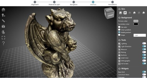
ARIADNEplus Visual Media Service 3D configurator: toward full guided publication of high-resolution 3D dataARIADNEplus Visual Media Service 3D configurator: a new tool for the visual organisation of 3D datasetsRecommended by Ian Moffat based on reviews by Sebastian Hageneuer, Vayia Panagiotidis, Erik Champion and Martina Trognitz
The manuscript "ARIADNEplus Visual Media Service 3D configurator: toward full guided publication of high-resolution 3D data" by Potenziani et al. [1] provides an excellent introduction to the Visual Media Service 3D Configurator. This is an exciting tool, focused on cultural heritage, that forms part of the Visual Media Service, a web-based platform for uploading a range of complex data sets, including high-resolution images, Reflectance Transformation Imaging images and 3D models and transforming them into an appropriate format for interation and visualisation on the web. The 3D Configurator Tool provides researchers with a wizard which assist with the presentation of 3D models. This manuscript provides a history and context for the development of the Visual Media Service and previous related tools such as 3DHOP, Nexus and Relight/OpenLIME. It also provides detailed information about the functionality of the 3D Configurator, including the Alignment, Material & Light, Navigation, Interface and Annotation steps. The Discussion section provides information about applications and users of the Visual Media Service, current limitations and planned future developments. Reviewers Hageneuer, Champion, Trognitz and Panagiotidis all provided important suggestions to the authors which have improved the clarity and scope of this manuscript. While this manscript does not present a case study using this tool, I recommend it to readers as a detailed and clear introduction to the Visual Media Service 3D configurator which may inspire them to use this for their own research. [1] Potenziani, M., Ponchio, F., Callieri, M., and Cignoni, P. (2024). ARIADNEplus Visual Media Service 3D configurator: toward full guided publication of high-resolution 3D data. Zenodo, 8075050, ver. 5 peer-reviewed and recommended by Peer Community in Archaeology. https://doi.org/10.5281/zenodo.10894515 | ARIADNEplus Visual Media Service 3D configurator: toward full guided publication of high-resolution 3D data | Potenziani, Marco; Ponchio, Federico; Callieri, Marco; Cignoni, Paolo | <p>The use of digital visual media in everyday work is nowadays a common practice in many different domains, including Cultural Heritage (CH). Because of that, the presence of digital datasets in CH archives and repositories is becoming more and m... | | Computational archaeology | Ian Moffat | 2023-06-23 17:37:47 | ||
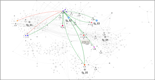
02 Sep 2023
Research workflows, paradata, and information visualisation: feedback on an exploratory integration of issues and practices - MEMORIA ISUsing information visualisation to improve traceability, transmissibility and verifiability in research workflowsRecommended by Isto Huvila based on reviews by Adéla Sobotkova and 2 anonymous reviewersThe paper “Research workflows, paradata, and information visualisation: feedback on an exploratory integration of issues and practices - MEMORIA IS” (Dudek & Blaise, 2023) describes a prototype of an information system developed to improve the traceability, transmissibility and verifiability of archaeological research workflows. A key aspect of the work with MEMORIA is to make research documentation and the workflows underpinning the conducted research more approachable and understandable using a series of visual interfaces that allow users of the system to explore archaeological documentation, including metadata describing the data and paradata that describes its underlying processes. The work of Dudek and Blaise address one of the central barriers to reproducibility and transparency of research data and propose a set of both theoretically and practically well-founded tools and methods to solve this major problem. From the reported work on MEMORIA IS, information visualisation and the proposed tools emerge as an interesting and potentially powerful approach for a major push in improving the traceability, transmissibility and verifiability of research data through making research workflows easier to approach and understand. In comparison to technical work relating to archaeological data management, this paper starts commendably with a careful explication of the conceptual and epistemic underpinnings of the MEMORIA IS both in documentation research, knowledge organisation and information visualisation literature. Rather than being developed on the basis of a set of opaque assumptions, the meticulous description of the MEMORIA IS and its theoretical and technical premises is exemplary in its transparence and richness and has potential for a long-term impact as a part of the body of literature relating to the development of archaeological documentation and documentation tools. While the text is sometimes fairly densely written, it is worth taking the effort to read it through. Another major strength of the paper is that it provides a rich set of examples of the workings of the prototype system that makes it possible to develop a comprehensive understanding of the proposed approaches and assess their validity. As a whole, this paper and the reported work on MEMORIA IS forms a worthy addition to the literature on and practical work for developing critical infrastructures for data documentation, management and access in archaeology. Beyond archaeology and the specific context of the discussed work discussed this paper has obvious relevance to comparable work in other fields. ReferencesDudek, I. and Blaise, J.-Y. (2023) Research workflows, paradata, and information visualisation: feedback on an exploratory integration of issues and practices - MEMORIA IS, Zenodo, 8252923, ver. 3 peer-reviewed and recommended by Peer Community in Archaeology. https://doi.org/10.5281/zenodo.8252923
| Research workflows, paradata, and information visualisation: feedback on an exploratory integration of issues and practices - MEMORIA IS | Dudek Iwona, Blaise Jean-Yves | <p>The paper presents an exploratory web information system developed as a reaction to practical and epistemological questions, in the context of a scientific unit studying the architectural heritage (from both historical sciences perspective, and... | | Computational archaeology | Isto Huvila | 2023-05-02 12:50:39 |


