
Latest recommendations

| Id | Title * | Authors * | Abstract * | Picture * ▲ | Thematic fields * | Recommender | Reviewers | Submission date | |
|---|---|---|---|---|---|---|---|---|---|
12 Apr 2024
Survey Planning, Allocation, Costing and Evaluation (SPACE) Project: Developing a Tool to Help Archaeologists Conduct More Effective SurveysA new tool to increase the robustness of archaeological field surveyRecommended by Jitte Waagen based on reviews by Philip Verhagen and Tymon de Haas based on reviews by Philip Verhagen and Tymon de Haas
This well-written and interesting paper ‘Survey Planning, Allocation, Costing and Evaluation (SPACE) Project: Developing a Tool to Help Archaeologists Conduct More Effective Surveys’ deals with the development of a ‘modular, accessible, and simple web-based platform for survey planning and quality assurance’ in the area of pedestrian field survey methods (Banning et al. 2024). Although there have been excellent treatments of statistics in archaeological field survey (among which various by the first author: Banning 2020, 2021), and there is continuous methodological debate on platforms such as the International Mediterranean Survey Workshop (IMSW), in papers dealing with the current development and state of the field (Knodell et al. 2023), good practices (Attema et al. 2020) or the merits of a quantifying approach to archaeological densities (cf. de Haas et al. 2023), this paper rightfully addresses the lack of rigorous statistical approaches in archaeological field survey. As argued by several scholars such as Orton (2000), this mainly appears the result of lack of knowledge/familiarity/resources to bring in the required expertise etc. with the application of seemingly intricate statistics (cf. Waagen 2022). In this context this paper presents a welcome contribution to the feasibility of a robust archaeological field survey design. The SPACE application, under development by the authors, is introduced in this paper. It is a software tool that aims to provide different modules to assist archaeologists to make calculations for sample size, coverage, stratification, etc. under the conditions of survey goals and available resources. In the end, the goal is to ensure archaeological field surveys will attain their objectives effectively and permit more confidence in the eventual outcomes. The module concerning Sweep Widths, an issue introduced by the main author in 2006 (Banning 2006) is finished; the sweep width assessment is a methodology to calibrate one’s survey project for artefact types, landscape, visibility and person-bound performance, eventually increasing the quality (comparability) of the collected samples. This is by now a well-known calibration technique, yet little used, so this effort to make that more accessible is certainly laudable. An excellent idea, and another aim of this project, is indeed to build up a database with calibration data, so applying sweep-width corrections will become easier accessible to practitioners who lack time to set up calibration exercises. It will be very interesting to have a closer look at the eventual platform and to see if, and how, it will be adapted by the larger archaeological field survey community, both from an academic research perspective as from a heritage management point of view. I happily recommend this paper and all debate relating to it, including the excellent peer reviews of the manuscript by Philip Verhagen and Tymon de Haas (available as part of this PCI recommendation procedure), to any practitioner of archaeological field survey. References Attema, P., Bintliff, J., Van Leusen, P.M., Bes, P., de Haas, T., Donev, D., Jongman, W., Kaptijn, E., Mayoral, V., Menchelli, S., Pasquinucci, M., Rosen, S., García Sánchez, J., Luis Gutierrez Soler, L., Stone, D., Tol, G., Vermeulen, F., and Vionis. A. 2020. “A guide to good practice in Mediterranean surface survey projects”, Journal of Greek Archaeology 5, 1–62. https://doi.org/10.32028/9781789697926-2 Banning, E.B., Alicia L. Hawkins, S.T. Stewart, Sweep widths and the detection of artifacts in archaeological survey, Journal of Archaeological Science, Volume 38, Issue 12, 2011, Pages 3447-3458. https://doi.org/10.1016/j.jas.2011.08.007 Banning, E.B. 2020. Spatial Sampling. In: Gillings, M., Hacıgüzeller, P., Lock, G. (eds.) Archaeological Spatial Analysis. A Methodological Guide. Routledge. Banning, E.B. 2021. Sampled to Death? The Rise and Fall of Probability Sampling in Archaeology. American Antiquity, 86(1), 43-60. https://doi.org/10.1017/aaq.2020.39 Banning, E. B. Steven Edwards, & Isaac Ullah. (2024). Survey Planning, Allocation, Costing and Evaluation (SPACE) Project: Developing a Tool to Help Archaeologists Conduct More Effective Surveys. Zenodo, 8072178, ver. 9 peer-reviewed and recommended by Peer Community in Archaeology. https://doi.org/10.5281/zenodo.8072178 Knodell, A.R., Wilkinson, T.C., Leppard, T.P. et al. 2023. Survey Archaeology in the Mediterranean World: Regional Traditions and Contributions to Long-Term History. J Archaeol Res 31, 263–329 (2023). https://doi.org/10.1007/s10814-022-09175-7 Orton, C. 2000. Sampling in Archaeology. Cambridge University Press. https://doi.org/10.1017/CBO9781139163996 Waagen, J. 2022. Sampling past landscapes. Methodological inquiries into the bias problems of recording archaeological surface assemblages. PhD-Thesis. https://hdl.handle.net/11245.1/e9cb922c-c7e4-40a1-b648-7b8065c46880 de Haas, T., Leppard, T. P., Waagen, J., & Wilkinson, T. (2023). Myopic Misunderstandings? A Reply to Meyer (JMA 35(2), 2022). Journal of Mediterranean Archaeology, 36(1), 127-137. https://doi.org/10.1558/jma.27148 | Survey Planning, Allocation, Costing and Evaluation (SPACE) Project: Developing a Tool to Help Archaeologists Conduct More Effective Surveys | E. B. Banning, Steven Edwards, and Isaac Ullah | <p>Designing an effective archaeological survey can be complicated and confidence that it was effective requires post-survey evaluation. The goal of SPACE is to develop software to facilitate survey designers’ decisions and partially automate tool... | | Computational archaeology, Landscape archaeology | Jitte Waagen | 2023-06-28 13:42:28 | ||
23 May 2024
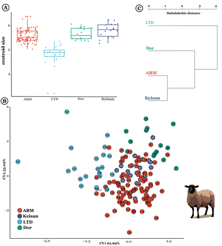
The contribution of Mediterranean connectivity to morphological variability in Iron Age sheep of the Eastern MediterraneanExploring eastern Mediterranean Iron Age coastal connections through sheep astragali using geometric morphometricsRecommended by Louise Le Meillour based on reviews by 4 anonymous reviewers
It currently seems obvious that the Mediterranean basin is a place of great exchanges of cultures, populations and goods. Although studies have focused quite extensively on the archaeology of maritime exchanges [1–3], it is challenging to assess archaeologically to what extent these networks had an influence on the biology of domesticated animals in the past, or even if animals were part of the trip. The question of past populations establishing extensive connections in the Mediterranean basin during the Iron Age and Persian period and especially, if these population exchange livestock and how these connections contributed to the animals phenotype or morphotype diversity is still difficult to document in the (zoo)archaeological record. These are amongst the questions Harding et al. [4] are making an attempt at documenting. Focusing on archaeological deposits from Cyprus and Israel in the eastern part of the Mediterranean basin, they use sheep astragali as a proxy to explore the potential connections that might have existed between evolution of the animals’ morphology and exchanges through sea travel. Postulating that animals from inland sites should have variant morphology from those of coastal sites due to more intensive exchanges for the latter, mainly because of the incorporation of non-native animals, they conducted geometric morphometrics analyses to make an attempt at documenting the phenomenon. Observing changes in size and shape, but also an increased morphological variability within the assemblages from coastal sites, they nicely discuss and put their results in perspectives with the archaeological record and literature [5,6]. Although, as they acknowledge, their sample size is rather limited to draw any general conclusion, this paper sheds new lights on the influence of maritime transport and its influence over domesticated sheep diversity between Cyprus and the southern Levant, paving the way for future studies. References | The contribution of Mediterranean connectivity to morphological variability in Iron Age sheep of the Eastern Mediterranean | Sierra A. Harding, Angelos Hadjikoumis, Shyama Vermeersch, Nimrod Marom | <p>The movement of livestock across the Mediterranean is well-documented in the Neolithic era, but its significance during subsequent periods has received less attention. This study explores potential evidence for maritime connections between shee... | | Bioarchaeology, Mediterranean, Zooarchaeology | Louise Le Meillour | Anonymous | 2023-12-07 10:10:34 | |
02 May 2024
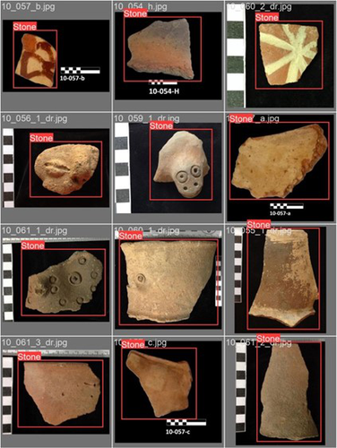
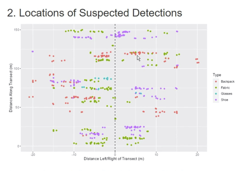
Machine Learning for UAV and Ground-Captured Imagery: Toward Standard PracticesA step forward in detecting small objects in UAV data for archaeological surveyingRecommended by Alex Brandsen based on reviews by 2 anonymous reviewers
In this paper [1], the authors describe how they apply machine learning with YOLOv5 to classify visual data, aiming to enhance understanding of archaeological phenomena before conducting destructive fieldwork. Despite challenges, the integration of machine learning with remote sensing technology was seen as transformative, enabling precise recording of areas of interest and assessment of environmental risk factors. The paper discusses successes, failures, and future directions in machine learning research, emphasising the need for standardisation and integration of streamlined methods. The application of machine learning techniques facilitates non-destructive analysis of material culture records, improving conservation efforts and offering insights into both past and contemporary phenomena. While the initial use of YOLOv5 showed potential for consistent detection of archaeological features, further refinement and dataset enlargement are deemed necessary for broader application in non-destructive archaeological surveying. The authors advocate for the integration of machine learning tools in archaeological research to save time, resources, and promote ethical digital recording practices. They highlight the importance of standardised methodologies to enhance credibility and reproducibility, aiming to contribute to the ongoing dialogue in computational archaeology. Overall, I think this paper is a good step forward in detecting small objects in UAV data, and contains useful information for similar studies. The aim towards greater reproducibility and standardisation is of course shared more widely in the machine learning community, and this study is a good example of how to approach this. References [1] Sharp, K., Christofis, B., Eslamiat, H., Nepal, U. and Osores Mendives, C. (2024). Machine Learning for UAV and Ground-Captured Imagery: Toward Standard Practices. Zenodo, 8307612, ver. 5 peer-reviewed and recommended by Peer Community in Archaeology. https://doi.org/10.5281/zenodo.8307612 | Machine Learning for UAV and Ground-Captured Imagery: Toward Standard Practices | Sharp Kayeleigh, Christofis Brooklyn, Eslamiat Hossein, Nepal Upesh, Osores Mendives Carlos | <p>Our collaborative work began in 2019 with the intent to overcome obstacles that had arisen from the inability to access curated artifact collections from remote locations. It was our specific aim to not only create digital twins of excavated ob... | | Ceramics, Computational archaeology, Remote sensing, South America | Alex Brandsen | 2023-09-01 09:56:18 | ||
29 Jan 2024
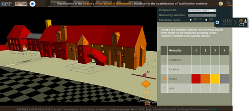
Visual encoding of a 3D virtual reconstruction's scientific justification: feedback from a proof-of-concept research3D Models, Knowledge and Visualization: a prototype for 3D virtual models according to plausible criteriaRecommended by Daniel Carvalho based on reviews by Robert Bischoff and Louise TharandtThe construction of 3D realities is deeply embedded in archaeological practices. From sites to artifacts, archaeology has dedicated itself to creating digital copies for the most varied purposes. The paper “Visual encoding of a 3D virtual reconstruction's 3 scientific justification: feedback from a proof-of-concept research” (Jean-Yves et al 2024) represents an advance, in the sense that it does not just deal with a three-dimensional theory for archaeological practice, but rather offers proposals regarding the epistemic component, how it is possible to represent knowledge through the workflow of 3D virtual reconstructions themselves. The authors aim to unite three main axes - knowledge modeling, visual encoding and 3D content reuse - (Jean-Yves et al 2024: 2), which, for all intents and purposes, form the basis of this article. With regard to the first aspect, this work questions how it is possible to transmit the knowledge we want to a 3D model and how we can optimize this epistemic component. A methodology based on plausibility criteria is offered, which, for the archaeological field, offers relevant space for reflection. Given our inability to fully understand the object or site that is the subject of the 3D representation, whether in space or time, building a method based on probabilistic categories is probably one of the most realistic approaches to the realities of the past. Thus, establishing a plausibility criterion allows the user to question the knowledge that is transmitted through the representation, and can corroborate or refute it in future situations. This is because the role of reusing these models is of great interest to the authors, a perfectly justifiable sentiment, as it encourages a critical view of scientific practices. Visual encoding is, in terms of its conjunction with knowledge practices, a key element. The notion of simplicity under Maeda's (2006) design principles not only represents a way of thinking that favors operability, but also a user-friendly design in the prototype that the authors have created. This is also visible when it comes to the reuse of parts of the models, in a chronological logic: adapting the models based on architectural elements that can be removed or molded is a testament to intelligent design, whereby instead of redoing models in their entirety, they are partially used for other purposes. All these factors come together in the final prototype, a web application that combines relational databases (RDBMS) with a data mapper (MassiveJS), using the PHP programming language. The example used is the Marmoutier Abbey hostelry, a centuries-old building which, according to the sources presented, has evolved architecturally over several centuries ((Jean-Yves et al 2024: 8). These states of the building are represented visually through architectural elements based on their existence, location, shape and size, always in terms of what is presented as being plausible. This allows not only the creation of a matrix in which various categories are related to various architectural elements, but also a visual aid, through a chromatic spectrum, of the plausibility that the authors are aiming for. In short, this is an article that seeks to rethink the degree of knowledge we can obtain through 3D visualizations and that does not take models as static, but rather realities that must be explored, recycled and reinterpreted in the light of different data, users and future research. For this reason, it is a work of great relevance to theoretical advances in 3D modeling adapted to archaeology.
References Blaise, J.-Y., Dudek, I., Bergerot, L. and Gaël, S. (2024). Visual encoding of a 3D virtual reconstruction's scientific justification: feedback from a proof-of-concept research, Zenodo, 7983163, ver. 3 peer-reviewed and recommended by Peer Community in Archaeology. https://doi.org/10.5281/zenodo.10496540 John Maeda. (2006). The Laws of Simplicity. MIT Press, Cambridge, MA, USA. | Visual encoding of a 3D virtual reconstruction's scientific justification: feedback from a proof-of-concept research | J.Y Blaise, I.Dudek, L.Bergerot, G.Simon | <p> 3D virtual reconstructions have become over the last decades a classical mean to communicate about analysts’ visions concerning past stages of development of an edifice or a site. However, they still today remain quite often a one-s... | | Computational archaeology, Spatial analysis | Daniel Carvalho | 2023-05-30 00:43:03 | ||
05 Jun 2023

SEAHORS: Spatial Exploration of ArcHaeological Objects in R ShinyAnalyzing piece-plotted artifacts just got simpler: A good solution to the wrong problem?Recommended by Reuven Yeshurun based on reviews by Frédéric Santos, Jacqueline Meier and Maayan LevPaleolithic archaeologists habitually measure 3-coordinate data for artifacts in their excavations. This was first done manually, and in the last three decades it is usually performed by a total station and associated hardware. While the field recording procedure is quite straightforward, visualizing and analyzing the data are not, often requiring specialized proprietary software or coding expertise. Here, Royer and colleagues (2023) present the SEAHORS application, an elegant solution for the post-excavation analysis of artifact coordinate data that seems to be instantly useful for numerous archaeologists. SEAHORS allows one to import and organize field data (Cartesian coordinates and point description), which often comes in a variety of formats, and to create various density and distribution plots. It is specifically adapted to the needs of archaeologists, is free and accessible, and much simpler to use than many commercial programs. The authors further demonstrate the use of the application in the post-excavation analysis of the Cassenade Paleolithic site (see also Discamps et al., 2019). While in no way detracting from my appreciation of Royer et al.’s (2023) work, I would like to play the devil’s advocate by asking whether, in the majority of cases, field recording of artifacts in three coordinates is warranted. Royer et al. (2023) regard piece plotting as “…indispensable to propose reliable spatial planimetrical and stratigraphical interpretations” but this assertion does not hold in all (or most) cases, where careful stratigraphic excavation employing thin volumetric units would do just as well. Moreover, piece-plotting has some serious drawbacks. The recording often slows excavations considerably, beyond what is needed for carefully exposing and documenting the artifacts in their contexts, resulting in smaller horizontal and vertical exposures (e.g., Gilead, 2002). This typically hinders a fuller stratigraphic and contextual understanding of the excavated levels and features. Even worse, the method almost always creates a biased sample of “coordinated artifacts”, in which the most important items for understanding spatial patterns and site-formation processes – the small ones – are underrepresented. Some projects run the danger of treating the coordinated artifacts as bearing more significance than the sieve-recovered items, preferentially studying the former with no real justification. Finally, the coordinated items often go unassigned to a volumetric unit, effectively disconnecting them from other types of data found in the same depositional contexts. The advantages of piece-plotting may, in some cases, offset the disadvantages. But what I find missing in the general discourse (certainly not in the recommended preprint) is the “theory” behind the seemingly technical act of 3-coordinate recording (Yeshurun, 2022). Being in effect a form of sampling, this practice needs a rethink about where and how to be applied; what depositional contexts justify it, and what the goals are. These questions should determine if all “visible” artifacts are plotted, or just an explicitly defined sample of them (e.g., elongated items above a certain length threshold, which should be more reliable for fabric analysis), or whether the circumstances do not actually justify it. In the latter case, researchers sometimes opt for using “virtual coordinates” within in each spatial unit (typically 0.5x0.5 m), essentially replicating the data that is generated by “real” coordinates and integrating the sieve-recovered items as well. In either case, Royer et al.’s (2023) solution for plotting and visualizing labeled points within intra-site space would indeed be an important addition to the archaeologists’ tool kits.
References cited Discamps, E., Bachellerie, F., Baillet, M. and Sitzia, L. (2019). The use of spatial taphonomy for interpreting Pleistocene palimpsests: an interdisciplinary approach to the Châtelperronian and carnivore occupations at Cassenade (Dordogne, France). Paleoanthropology 2019, 362–388. https://doi.org/10.4207/PA.2019.ART136 Gilead, I. (2002). Too many notes? Virtual recording of artifacts provenance. In: Niccolucci, F. (Ed.). Virtual Archaeology: Proceedings of the VAST Euroconference, Arezzo 24–25 November 2000. BAR International Series 1075, Archaeopress, Oxford, pp. 41–44. Royer, A., Discamps, E., Plutniak, S. and Thomas, M. (2023). SEAHORS: Spatial Exploration of ArcHaeological Objects in R Shiny Zenodo, 7957154, ver. 2 peer-reviewed and recommended by Peer Community in Archaeology. https://doi.org/10.5281/zenodo.7929462 Yeshurun, R. (2022). Intra-site analysis of repeatedly occupied camps: Sacrificing “resolution” to get the story. In: Clark A.E., Gingerich J.A.M. (Eds.). Intrasite Spatial Analysis of Mobile and Semisedentary Peoples: Analytical Approaches to Reconstructing Occupation History. University of Utah Press, pp. 27–35.
| SEAHORS: Spatial Exploration of ArcHaeological Objects in R Shiny | ROYER, Aurélien, DISCAMPS, Emmanuel, PLUTNIAK, Sébastien, THOMAS, Marc | <p style="text-align: justify;">This paper presents SEAHORS, an R shiny application available as an R package, dedicated to the intra-site spatial analysis of piece-plotted archaeological remains. This open-source script generates 2D and 3D scatte... | | Computational archaeology, Spatial analysis, Theoretical archaeology | Reuven Yeshurun | 2023-02-24 16:01:44 | ||
03 Feb 2024
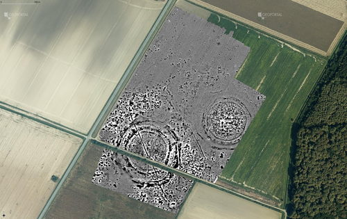
Digital surface models of crops used in archaeological feature detection – a case study of Late Neolithic site Tomašanci-Dubrava in Eastern CroatiaWhat lies on top lies also beneath? Connecting crop surface modelling to buried archaeology mapping.Recommended by Markos Katsianis based on reviews by Ian Moffat and Geert Verhoeven
This paper (Sosic et al. 2024) explores the Neolithic landscape of the Sopot culture in Đakovština, Eastern Slavonija, revealing a network of settlements through a multi-faceted approach that combines aerial archaeology, magnetometry, excavation, and field survey. This strategy facilitates scalable research tailored to the particularities of each site and allows for improved representations of buried archaeology with minimal intrusion. Using the site of Tomašanci-Dubrava as an example of the overall approach, the study further explores the use of drone imagery for 3D surface modeling, revealing a consistent correlation between crop surface elevation during full plant growth and ground terrain after ploughing, attributed to subsurface archaeological features. Results are correlated with magnetic survey and test-pitting data to validate the micro-topography and clarify the relationship between different subsurface structures. The results obtained are presented in a comprehensive way, including their source data, and are contextualized in relation to conventional cropmark detection approaches and expectations. I found this aspect very interesting, since the crop surface and terrain models contradict typical or textbook examples of cropmark detection, where the vegetation is projected to appear higher in ditches and lower in areas with buried archaeology (Renfrew & Bahn 2016, 82). Regardless, the findings suggest the potential for broader applications of crop surface or canopy height modelling in landscape wide surveys, utilizing ALS data or aerial photographs. It seems then that the authors make a valid argument for a layered approach in landscape-based site detection, where aerial imagery can be used to accurately map the topography of areas of interest, which can then be further examined at site scale using more demanding methods, such as geophysical survey and excavation. This scalability enhances the research's relevance in broader archaeological and geographical contexts and renders it a useful example in site detection and landscape-scale mapping. References Renfrew, C. and Bahn, P. (2016). Archaeology: theories, methods and practice. Thames and Hudson. Sosic Klindzic, R., Vuković, M., Kalafatić, H. and Šiljeg, B. (2024). Digital surface models of crops used in archaeological feature detection – a case study of Late Neolithic site Tomašanci-Dubrava in Eastern Croatia, Zenodo, 7970703, ver. 4 peer-reviewed and recommended by Peer Community in Archaeology. https://doi.org/10.5281/zenodo.7970703 | Digital surface models of crops used in archaeological feature detection – a case study of Late Neolithic site Tomašanci-Dubrava in Eastern Croatia | Sosic Klindzic Rajna; Vuković Miroslav; Kalafatić Hrvoje; Šiljeg Bartul | <p>This paper presents the results of a study on the neolithic landscape of the Sopot culture in the area of Đakovština in Eastern Slavonija. A vast network of settlements was uncovered using aerial archaeology, which was further confirmed and chr... | | Landscape archaeology, Neolithic, Remote sensing, Spatial analysis | Markos Katsianis | 2023-09-01 12:57:04 |


