
A step forward in detecting small objects in UAV data for archaeological surveying
 based on reviews by 2 anonymous reviewers
Machine Learning for UAV and Ground-Captured Imagery: Toward Standard Practices
Abstract
Recommendation: posted 01 May 2024, validated 02 May 2024
Brandsen, A. (2024) A step forward in detecting small objects in UAV data for archaeological surveying. Peer Community in Archaeology, 100405. https://doi.org/10.24072/pci.archaeo.100405
Recommendation
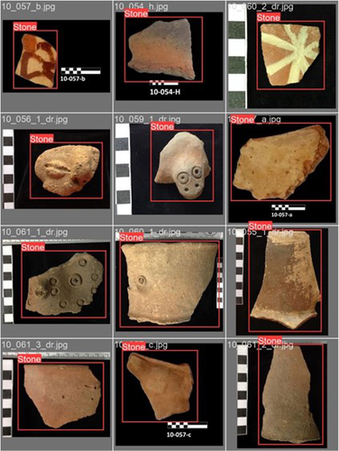
In this paper [1], the authors describe how they apply machine learning with YOLOv5 to classify visual data, aiming to enhance understanding of archaeological phenomena before conducting destructive fieldwork. Despite challenges, the integration of machine learning with remote sensing technology was seen as transformative, enabling precise recording of areas of interest and assessment of environmental risk factors. The paper discusses successes, failures, and future directions in machine learning research, emphasising the need for standardisation and integration of streamlined methods. The application of machine learning techniques facilitates non-destructive analysis of material culture records, improving conservation efforts and offering insights into both past and contemporary phenomena. While the initial use of YOLOv5 showed potential for consistent detection of archaeological features, further refinement and dataset enlargement are deemed necessary for broader application in non-destructive archaeological surveying. The authors advocate for the integration of machine learning tools in archaeological research to save time, resources, and promote ethical digital recording practices. They highlight the importance of standardised methodologies to enhance credibility and reproducibility, aiming to contribute to the ongoing dialogue in computational archaeology.
Overall, I think this paper is a good step forward in detecting small objects in UAV data, and contains useful information for similar studies. The aim towards greater reproducibility and standardisation is of course shared more widely in the machine learning community, and this study is a good example of how to approach this.
References
[1] Sharp, K., Christofis, B., Eslamiat, H., Nepal, U. and Osores Mendives, C. (2024). Machine Learning for UAV and Ground-Captured Imagery: Toward Standard Practices. Zenodo, 8307612, ver. 5 peer-reviewed and recommended by Peer Community in Archaeology. https://doi.org/10.5281/zenodo.8307612

The recommender in charge of the evaluation of the article and the reviewers declared that they have no conflict of interest (as defined in the code of conduct of PCI) with the authors or with the content of the article. The authors declared that they comply with the PCI rule of having no financial conflicts of interest in relation to the content of the article.
n/a
Evaluation round #2
DOI or URL of the preprint: https://doi.org/10.5281/zenodo.8308464
Version of the preprint: 2
Author's Reply, 29 Apr 2024
Hello Alex,
I have made the requested text edit, added a statement about the representations in figures 4a and 7 and uploaded my data, providing a DOI and uploaded the final version of our paper with these changes.
Thank you for your time!
Kayeleigh
Decision by Alex Brandsen, posted 02 Apr 2024, validated 02 Apr 2024
Dear Kayeleigh,
thank you for making these changes and uploading the updated manuscript. I'm satisfied with your edits based on the reviewer feedback. However, when doing a final check, I ran into a couple of small issues that should be resolved before I can recommend the paper:
- This is the main issue that needs to resolved: the code mentioned in the paper isn't shared anywhere (as far as I can see). Could you add this as a citation, or in the Zenodo archive? Ideally with the (raw) data as well, if you are allowed to share that, for full reproducability As per the PCI guidelines: https://archaeo.peercommunityin.org/PCIArchaeology/help/guide_for_authors#h_1044325634321613309419548
(Apologies for not picking this up in the first round of review!) - I got the updated manuscript through PCI, but on Zenodo the file is set to 'restricted'. Please make the next version open accessible.
- The newly added images 4b and 7 are a great addition. I can get the y axis from the title of each graph, but what is the x axis? I'm guessing epochs?
- Tiny typo: on line 222 'Varrt' should be 'Vaart'
Other than that, the paper is good to go. If you could make these changes, I'll write the final recommendation.
Kind regards,
Alex Brandsen.
Evaluation round #1
DOI or URL of the preprint: https://doi.org/10.5281/zenodo.8308464
Version of the preprint: 2
Author's Reply, 30 Mar 2024
Dear Reviewers,
First, we would like to thank you for your time and extremely helpful comments and recommendations. We recognize the effort that went into helping us to refine our paper and are very grateful.
Thank you for the opportunity to revise our paper.
We worked through your comments meticulously, clarifying concepts and standardizing language according to recommendations and reviewer commentary.
Several new sources were consulted and added as a result of reviewer[s] recommendations and guidance.
Much of the 'tedious' and repetitious language was either dropped or added as footnotes where applicable and moved some texts from the main body to the introduction and vice versa.
We have also added additional images per reviewer comments.
Kind regards,
Kayeleigh Sharp
Decision by Alex Brandsen, posted 09 Oct 2023, validated 09 Oct 2023
Dear authors,
I enjoyed reading your paper, and thought it was a useful addition to the ongoing discussions in this field.
Both reviewers highlighted some minor issues that would need to be resolved for this paper to be accepted. Please check their comments and fix or address the highlighted issues where possible. The overlap between the reviewers are to do with the structure of the paper, please make sure to address this point in detail.
I look forward to reading (and recommending) the edited paper!
Kind regards,
Alex Brandsen.
Reviewed by anonymous reviewer 2, 08 Sep 2023
Dear Authors,
I have reviewed your paper with much interest. Detecting small objects in UAV data would be a major step forward for archaeological surveying.
I do think that the paper needs to be restructured and that some references are missing (see enclosed document). Some parts are very (maybe too) detailed while other essential information is missing.
I hope the comments can help to improve the paper!
Download the review https://doi.org/10.24072/pci.archaeo.100405.rev11Reviewed by anonymous reviewer 1, 13 Sep 2023
The manuscript could be considered for publication after minor revisions.
Despite the results, it can be regarded as helpful for similar research. Specific points to be considered and answered by the authors can be found in the attached PDF.
1. Abstract: It gives clear information about work in 2019 but needs to give new specific work contributions and innovation of the present work. Could you explain how these results can be innovative? What benefits do new results offer?
2. Lines 75 – 80: Will fit better in the introduction section.
3. Lines 81 – 87: The author explains the terms of ML, DL and computer vision, but it would be more helpful for a diagram to be more apparent to readers.
An example you can find in the link below, even if the content is not a common field.
https://www.sciencedirect.com/science/article/pii/S135951132100235X
4. For this research, the authors selected the Yolo algorithm. Still, it needs to be clarified what others have been used or if the selection of the current algorithm was based only on the literature and, if so, in the literature, has Yolo been used for a related scope(provide reference).
5. Analytical Challenges: It would be helpful to refer to the resolution of the images since it is a crucial parameter. Accuracy Results depend on your dataset of the images and their properties. Also, you haven’t referred to the height of your flights but only that you plan to re-capture drone data at lower altitudes (approximately 15-20 meters).
6. A diagram of the methodology applied would be supported for the article.
7. A table with the results could be more helpful for the readers to have a full view of them.
Overall, it is satisfactory as a research article. Please create sub-sections that give a more scientific view of your manuscript.
Thank you
Download the review https://doi.org/10.24072/pci.archaeo.100405.rev12


