
Latest recommendations

| Id | Title | Authors▼ | Abstract | Picture | Thematic fields | Recommender | Reviewers | Submission date | |
|---|---|---|---|---|---|---|---|---|---|
02 May 2023
Transmission of lithic and ceramic technical know-how in the Early Neolithic of central-western Europe: Shedding Light on the Social Mechanisms underlying Cultural TransitionA Thought Provoking Consideration of Craft in the NeolithicRecommended by Clare Burke based on reviews by Bogdana Milić and 1 anonymous reviewerThe pioneering work of Leroi-Gourhan introduced archaeologists to the concept of the chaîne opératoire[1], whereby, like his supervisor Mauss[2], Leroi-Gourhan proposed direct links between bodily actions and aspects of cultural identity. The chaîne opératoire offers a powerful conceptual tool with which to reconstruct and describe the technological practices undertaken by craftspeople, linking material objects to the cultural context in which crafts are learnt. Although initially applied to lithics, the concept today is well known in ceramic studies, as well as, other material crafts, in order to identify aspects of tradition and identity through ideas linked to technological style[3,4] and communities of practice[5]. Utilizing this approach, Denis et al.[6] use the chaîne opératoire to look at both lithics and ceramics together from a diachronic viewpoint, to examine technical systems present over the transition between Linearbandkeramic (LBK) and post LBK Blicquy/Villeneuve-Saint German (BQY/VSG) timeframes. This much needed comparative and diachronic perspective, focuses on material from the sites of Vaux-et-Borset and Verlaine in Belgium, and has enabled the authors to consider the impact of changing social dynamics on these two crafts simultaneously. The authors examine the ceramic and lithic assemblages from a macroscopic and morphological perspective in order to identify techniques of production. The data gathered testifies to the dominance of one production technique for each craft within the LBK. There is particularly striking homogeneity noted for the lithics that suggests the transmission of a single tradition over the Hesbaye area, whilst the ceramics display greater regional diversity. The picture alters somewhat for the BQY/VSG material where it seems there is an increase in the diversity of production techniques, with both the introduction of new techniques, as well as a degree of hybridization of earlier techniques to form new BQY/VSG chaînes opératoires that have LBK roots. The BQY/VSG diversity noted for the lithics is especially interesting, with the introduction of techniques that attest to increased expertise which the authors attest to the migration of an external group. The results of this work have allowed Denis et al. to discuss multiple influences on the technical systems they identify. Rather than trying to fit the data within a single model, the authors demonstrate the need for nuance, considering the social changes associated with Neolithic migration and interactions, as multifaced and dynamic. As such, they are able to show not only the influence of contact with other groups, but that the apparent migration of external groups does not simply lead to the replacement of the crafting heritage already established at the sites they have examined. In concluding the authors acknowledge, that as scholars push the existing state of knowledge (in this respect analysis of raw materials would make an especially important contribution), the picture presented in the paper may alter. Future work will hopefully fill in current gaps, particularly in terms of how far the trends identified extend, and the extent to which the lithic and ceramic pictures diversify on a broader geographical scale. It is certain that based on such results, future work should adopt the comparative approach presented by the authors, who have demonstrated its explanatory potential for understanding the technical and cultural groups we all study. [2] Mauss, M. 2009 [1934]. Techniques, Technology and Civilisation. Edited and introduced by N. Schlanger. New York/Oxford: Durkheim Press/Berghahn Books. [3] Lechtman, H. 1977. Style in Technology: some early thoughts. In H. Lechtman and R.S. Merrill (eds.) Material Culture: styles, organization and dynamics of technology. Proceedings of the American Ethnological Society 1975, St. Paul, 3-20. [4] Gosselain, O. 1992. Technology and Style: Potters and Pottery Among Bafia of Cameroon. Man 27(3) 559- 586. htpps://doi.org/10.2307/2803929. [5] Wenger, E. 1998. Communities of practice: Learning, meaning, and identity. Cambridge: Cambridge University Press. [6] Denis, S., Gomart, L., Burnez-Lanotte, L. and Allard, P. (2023). Transmission of lithic and ceramic technical know-how in the Early Neolithic of central-western Europe: Shedding Light on the Social Mechanisms underlying Cultural Transition. OSF Preprints, gqnht, ver. 5 peer-reviewed and recommended by Peer Community in Archaeology. https://doi.org/10.31219/osf.io/gqnht
| Transmission of lithic and ceramic technical know-how in the Early Neolithic of central-western Europe: Shedding Light on the Social Mechanisms underlying Cultural Transition | Solène Denis, Louise Gomart, Laurence Burnez-Lanotte, Pierre Allard | <p>Research on the European Neolithisation agrees that a process of colonisation throughout the sixth millennium BC underlies the spread of agricultural ways of life on the continent. From central to central-western Europe, this colonisation path ... | | Ceramics, Europe, Lithic technology, Neolithic | Clare Burke | 2022-11-18 12:03:55 | ||
26 Sep 2022
The management of symbolic raw materials in the Late Upper Paleolithic of South-Western France: a shell ornaments perspectiveCaching up with the study of the procurement of symbolic raw materials in the Upper PalaeolithicRecommended by Beatrice Demarchi based on reviews by Begoña Soler Mayor , Catherine Dupont and Lawrence StrausThe manuscript "The management of symbolic raw materials in the Late Upper Paleolithic of South-Western France: a shell ornaments perspective" by Solange Rigaud and colleagues (Rigaud et al. 2022) is a perfect demonstration that appropriate scientific methodologies can be used effectively in order to enhance the historical value of findings from “old” collections, despite the lack of secure stratigraphic and contextual data. The shell assemblage (n = 377) investigated here (from Rochereil, Dordogne) had been excavated during the first half of the 20th century (Jude 1960) and reported in 1993 (Taborin 1993), but only this recent analysis revealed that it was composed of largely unmodified mollusc shells, most of allochthonous origin. Rigaud et al. interpret this finding as the raw materials used to produce personal ornaments. This is especially significant, because the focus of research has been on the manufacture, use and exchange of personal ornaments in prehistory, much less so on the procurement of the raw materials. As such, the manuscript adds substantially to the growing literature on Magdalenian social networks. The authors carried out detailed taxonomic analysis based on morphological and morphometric characteristics and identified at least nine different species, including Dentalium sp., Ocenebra erinaceus, Tritia reticulata and T. gibbosula, as well as some bivalve specimens (Mytilus, Glycymeris, Spondylus, Pecten). Most of the species are commonly found in personal ornament assemblages from the Magdalenian, reflecting intentional selection (also shown by the size sorting of some of the taxa), and cultural continuity. However, microscopic examinations revealed securely-identified anthropogenic modifications on a very limited number of specimens: one Glycymeris valve (used as an ochre container), one Cardiidae valve (presence of a groove), one perforated Tritia gibbosula and two perforated Tritia reticulata bearing striations. The authors interpret this combination of anthropogenic vs natural “signals” as signifying that the assemblage represents raw material selected and stored for further processing. Assessing the provenance and age of the shells is therefore paramount: the shells found at Rochereil belong to species that can be found on both the Atlantic and Mediterranean coasts. Assuming that molluscan taxa distribution in the past is comparable to that for the present day, this implies the exploitation of two catchment areas and long-distance transportation to the site: taking sea-level changes into account, during the Magdalenian the Mediterranean used to lie at a distance of 350 km from Rochereil, and the Atlantic was not significantly closer (~200 km). Importantly, exploitation of fossil shells cannot be discounted on the basis of the data presented here; direct dating of some of the specimens (e.g. by radiocarbon, or amino acid racemisation geochronology) would be beneficial to clarify this issue and in general to improve chronological control on the accumulation of shells. Nonetheless, the authors argue that the closest fossil deposits also lie more than 200 km away from the site, thus the material is allochthonous in origin. In synthesis, the Rochereil assemblage represents an important step towards a better understanding of the procurement chain and of the production of ornaments during the European Upper Palaeolithic. References Jude, P. E. (1960). La grotte de Rocherreil: station magdalénienne et azilienne, Masson. Rigaud, S., O'Hara, J., Charles, L., Man-Estier, E. and Paillet, P. (2022) The management of symbolic raw materials in the Late Upper Paleolithic of South-Western France: a shell ornaments perspective. SocArXiv, z7pqg, ver. 4 peer-reviewed and recommended by Peer community in Archaeology. https://doi.org/10.31235/osf.io/z7pqg Taborin, Y. (1993). La parure en coquillage au Paléolithique, CNRS éditions. | The management of symbolic raw materials in the Late Upper Paleolithic of South-Western France: a shell ornaments perspective | Solange Rigaud, John O’Hara, Laurent Charles, Elena Man-Estier, Patrick Paillet | <p>Personal ornaments manufactured on marine and fossil shell are a significant element of Upper Palaeolithic symbolic material culture, and are often found at considerable distances from Pleistocene coastlines or relevant fossil deposits. Here, w... | | Europe, Symbolic behaviours, Upper Palaeolithic | Beatrice Demarchi | 2022-04-23 19:20:02 | ||
24 Jun 2021
The strength of parthood ties. Modelling spatial units and fragmented objects with the TSAR method – Topological Study of Archaeological RefittingA practical computational approach to stratigraphic analysis using conjoinable material culture.Recommended by Hector A. Orengo based on reviews by Robert Bischoff, Matthew Peeples and 1 anonymous reviewerThe paper by Plutniak [1] presents a new method that uses refitting to help interpret stratigraphy using the topological distribution of conjoinable material culture. This new method opens up new avenues to the archaeological use of network analysis but also to assess the integrity of interpreted excavation layers. Beyond its evident applicability to standard excavation practice, the paper presents a series of characteristics that exemplify archaeological publication best practices and, as someone more versed in computational than in refitting studies I would like to comment upon. It was no easy task to find adequate reviewers for this paper as it combines techniques and expertise that are not commonly found together in individual researchers. However, Plutniak, with help from three reviewers, particularly M. Peeples, a leading figure in archaeological applications of network science, makes a considerable effort to be accessible to non-specialist archaeologists. The core Topological Study of Archaeological Refitting (TSAR) method is freely accessible as the R package archeofrag, which is available at the Comprehensive R Archive Network (https://CRAN.R-project.org/package=archeofrag) that can be applied without the need to understand all its mathematical, graph theory and coding aspects. Beside these, an online interface including test data has been provided (https://analytics.huma-num.fr/Sebastien.Plutniak/archeofrag/), which aims to ease access to the method to those archaeologists inexperienced with R. Finally, supplementary material showing how to use the package and evaluating its potential through excellent examples is provided as both pdf and Rmw (Sweave) files. This is an important companion for the paper as it allows a better understanding of the methods presented in the paper and its practical application. The author shows particular care in testing the potential and capabilities of the method. For example, a function is provided “frag.observer.failure” to test the robustness of the edge count method against the TSAR method, which is able to prove that TSAR can deal well with incomplete information. As a further step in this direction both simulated and real field-acquired data are used to test the method which further proves that archeofrag is not only able to quantitatively assess the mixture of excavated layers but to propose meaningful alternatives, which no doubt will add an increased methodological consistency and thoroughness to previous quantitative approaches to material refitting work, even when dealing with very complex stratigraphies. All in all, this paper makes an important contribution to core archaeological practice through the use of innovative, reproducible and accessible computational methods. I fully endorse it for the conscious and solid methods it presents but also for its adherence to open publication practices. I hope that it can become of standard use in the reconstruction of excavated stratigraphical layers through conjoinable material culture.
[1] Plutniak, S. 2021. The Strength of Parthood Ties. Modelling Spatial Units and Fragmented Objects with the TSAR Method – Topological Study of Archaeological Refitting. OSF Preprints, q2e69, ver. 3 Peer-reviewed and recommended by PCI Archaeology. https://doi.org/10.31219/osf.io/q2e69. | The strength of parthood ties. Modelling spatial units and fragmented objects with the TSAR method – Topological Study of Archaeological Refitting | Sébastien Plutniak | <p>Refitting and conjoinable pieces have long been used in archaeology to assess the consistency of discrete spatial units, such as layers, and to evaluate disturbance and post-depositional processes. The majority of current methods, despite their... | | Computational archaeology, Taphonomy | Hector A. Orengo | 2021-01-14 18:31:01 | ||
16 Apr 2024
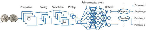
Creating an Additional Class Layer with Machine Learning to counter Overfitting in an Unbalanced Ancient Coin DatasetA significant contribution to the problem of unbalanced data in machine learning research in archaeologyRecommended by Alex Brandsen based on reviews by Simon Carrignon, Joel Santos and 1 anonymous reviewer based on reviews by Simon Carrignon, Joel Santos and 1 anonymous reviewer
This paper [1] presents an innovative approach to address the prevalent challenge of unbalanced datasets in coin type recognition, shifting the focus from coin class type recognition to coin mint recognition. Despite this shift, the issue of unbalanced data persists. To mitigate this, the authors introduce a method to split larger classes into smaller ones, integrating them into an 'additional class layer'. Three distinct machine learning (ML) methodologies were employed to identify new possible classes, with one approach utilising unsupervised clustering alongside manual intervention, while the others leverage object detection, and Natural Language Processing (NLP) techniques. However, despite these efforts, overfitting remained a persistent issue, prompting the authors to explore alternative methods such as dataset improvement and Generative Adversarial Networks (GANs). The paper contributes significantly to the intersection of ML techniques and archaeology, particularly in addressing overfitting challenges. Furthermore, the authors' candid acknowledgment of the limitations of their approaches serves as a valuable resource for researchers encountering similar obstacles. This study stems from the D4N4 project, aimed at developing a machine learning-based coin recognition model for the extensive "Corpus Nummorum" dataset, comprising over 19,600 coin types and 49,000 coins from various ancient landscapes. Despite encountering challenges with overfitting due to the dataset's imbalance, the authors' exploration of multiple methodologies and transparent documentation of their limitations enriches the academic discourse and provides a foundation for future research in this field. Reference [1] Gampe, S. and Tolle, K. (2024). Creating an Additional Class Layer with Machine Learning to counter Overfitting in an Unbalanced Ancient Coin Dataset. Zenodo, 8298077, ver. 4 peer-reviewed and recommended by Peer Community in Archaeology. https://doi.org/10.5281/zenodo.8298077 | Creating an Additional Class Layer with Machine Learning to counter Overfitting in an Unbalanced Ancient Coin Dataset | Sebastian Gampe, Karsten Tolle | <p>We have implemented an approach based on Convolutional Neural Networks (CNN) for mint recognition for our Corpus Nummorum (CN) coin dataset as an alternative to coin type recognition, since we had too few instances for most of the types (classe... | | Computational archaeology | Alex Brandsen | 2023-08-29 16:26:41 | ||
06 Aug 2023

A Focus on the Future of our Tiny Piece of the Past: Digital Archiving of a Long-term Multi-participant Regional ProjectA meticulous description of archiving research data from a long-running landscape research projectRecommended by Isto Huvila based on reviews by Dominik Hagmann and Iwona DudekThe paper “A Focus on the Future of our Tiny Piece of the Past: Digital Archiving of a Long-term Multi-participant Regional Project” (Madry et al., 2023) describes practices, challenges and opportunities encountered in digital archiving of a landscape research project running in Burgundy, France for more than 45 years. As an unusually long-running multi-disciplinary undertaking working with a large variety of multi-modal digital and non-digital data, the Burgundy project has lived through the development of documentation and archiving technologies from the 1970s until today and faced many of the challenges relating to data management, preservation and migration. The major strenght of the paper is that it provides a detailed description of the evolution of digital data archiving practices in the project including considerations about why some approaches were tested and abandoned. This differs from much of the earlier literature where it has been more common to describe individual solutions how digital archiving was either planned or was performed at one point of time. A longitudinal description of what was planned, how and why it has worked or failed so far, as described in the paper, provides important insights in the everyday hurdles and ways forward in digital archiving. As a description of a digital archiving initiative, the paper makes a valuable contribution for the data archiving scholarship as a case description of practices and considerations in one research project. For anyone working with data management in a research project either as a researcher or data manager, the text provides useful advice on important practical matters to consider ahead, during and after the project. The main advice the authors are giving, is to plan and act for data preservation from the beginning of the project rather than doing it afterwards. To succeed in this, it is crucial to be knowledgeable of the key concepts of data management—such as “digital data fixity, redundant backups, paradata, metadata, and appropriate keywords” as the authors underline—including their rationale and practical implications. The paper shows also that when and if unexpected issues raise, it is important to be open for different alternatives, explore ways forward, and in general be flexible. The paper makes also a timely contribution to the discussion started at the session “Archiving information on archaeological practices and work in the digital environment: workflows, paradata and beyond” at the Computer Applications and Quantitative 2023 conference in Amsterdam where it was first presented. It underlines the importance of understanding and communicating the premises and practices of how data was collected (and made) and used in research for successful digital archiving, and the similar pertinence of documenting digital archiving processes to secure the keeping, preservation and effective reuse of digital archives possible. ReferencesMadry, S., Jansen, G., Murray, S., Jones, E., Willcoxon, L. and Alhashem, E. (2023) A Focus on the Future of our Tiny Piece of the Past: Digital Archiving of a Long-term Multi-participant Regional Project, Zenodo, 7967035, ver. 3 peer-reviewed and recommended by Peer Community in Archaeology. https://doi.org/10.5281/zenodo.7967035 | A Focus on the Future of our Tiny Piece of the Past: Digital Archiving of a Long-term Multi-participant Regional Project | Scott Madry, Gregory Jansen, Seth Murray, Elizabeth Jones, Lia Willcoxon, Ebtihal Alhashem | <p>This paper will consider the practical realities that have been encountered while seeking to create a usable Digital Archiving system of a long-term and multi-participant research project. The lead author has been involved in archaeologic... | | Computational archaeology, Environmental archaeology, Landscape archaeology | Isto Huvila | 2023-05-24 18:46:34 | ||
12 Feb 2024
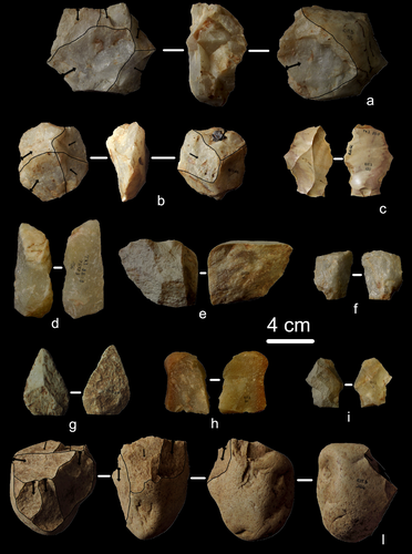
First evidence of a Palaeolithic occupation of the Po plain in Piedmont: the case of Trino (north-western Italy)Not Simply the Surface: Manifesting Meaning in What Lies Above.Recommended by Marcel Kornfeld based on reviews by Lawrence Todd, Jason LaBelle and 2 anonymous reviewersThe archaeological record comes in many forms. Some, such as buried sites from volcanic eruptions or other abrupt sedimentary phenomena are perhaps the only ones that leave relatively clean snapshots of moments in the past. And even in those cases time is compressed. Much, if not all other archaeological record is a messy affair. Things, whatever those things may be, artifacts or construction works (i.e., features), moved, modified, destroyed, warped and in a myriad of ways modified from their behavioral contexts. Do we at some point say the record is worthless? Not worth the effort or continuing investigation. Perhaps sometimes this may be justified, but as Daffara and colleagues show, heavily impacted archaeological remains can give us clues and important information about the past. Thoughtful and careful prehistorians can make significant contributions from what appear to be poor archaeological records. In the case of Daffara and colleagues, a number of important theoretical cross-sections can be recognized. For a long time surface archaeology was thought of simply as a way of getting a preliminary peak at the subsurface. From some of the earliest professional archaeologists (e.g., Kidder 1924, 1931; Nelson 1916) to the New Archaeologists of the 1960s, the link between the surface and subsurface was only improved in precision and systematization (Binford et al. 1970). However, at Hatchery West Binford and colleagues not only showed that surface material can be used more reliably to get at the subsurface, but that substantive behavioral inferences can be made with the archaeological record visible on the surface. Much more important are the behavioral implications drawn from surface material. I am not sure we can cite the first attempts at interpreting prehistory from the surface manifestations of the archaeological record, but a flurry of such approaches proliferated in the 1970s and beyond (Dunnell and Dancey 1983; Ebert 1992; Foley 1981). Off-site archaeology, non-site archaeology, later morphing into landscape archaeology all deal strictly with surface archaeological record to aid in understanding the past. With the current paper, Daffara and colleagues (2024) are clearly in this camp. Although still not widely accepted, it is clear that some behaviors (parts of systems) can only be approached from surface archaeological record. It is very unlikely that a future archaeologist will be able to excavate an entire human social/cultural system; people moving from season to season, creating multiple long and short term camps, travelling, procuring resources, etc. To excavate an entire system one would need to excavate 20,000 km2 or some similarly impossible task. Even if it was physically possible to excavate such an enormous area, it is very likely that some of contextual elements of any such system will be surface manifestations. Without belaboring the point, surface archaeological record yields data like any other archaeological record. We must contextual the archaeological artifacts or features weather they come from surface or below. Daffara and colleagues show us that we can learn about deep prehistory of northern Italy, with collections that were unsystematically collected, biased by agricultural as well as other land deformations agents. They carefully describe the regional prehistory as we know it, in particular specific well documented sites and assemblages as a means of applying such knowledge to less well controlled or uncontrolled collections.
References Binford, L., Binford, R. S. R., Whallon, R. and Hardin, M. A. (1970). Archaeology of Hatchery West. Memoirs of the Society for American Archaeology, No. 24, Washington D.C. Daffara, S., Giraudi, C., Berruti, G. L. F., Caracausi, S. and Garanzini, F. (2024). First evidence of a Palaeolithic frequentation of the Po plain in Piedmont: the case of Trino (north-western Italy), OSF Preprints, pz4uf, ver. 6 peer-reviewed and recommended by Peer Community in Archaeology. https://doi.org/10.31219/osf.io/pz4uf Dunnell, R. C. and Dancey, W. S. (1983). The siteless survey: a regional scale data collection strategy. In Advances in Archaeological Method and Theory, vol. 6, edited by Michael B. Schiffer, pp. 267-287. Academic Press, New York. Ebert, J. I. (1992). Distributional Archaeology. University of New Mexico Press, Albuquerque. Foley, R. A. (1981). Off site archaeology and human adaptation in eastern Africa: An analysis of regional artefact density in the Amboseli, Southern Kenya. British Archaeological Reports International Series 97. Cambridge Monographs in African Archaeology 3. Oxford England. Kidder, A. V. (1924). An Introduction to the Study of Southwestern Archaeology, With a Preliminary Account of the Excavations at Pecos. Papers of the Southwestern Expedition, Phillips Academy, no. 1. New Haven, Connecticut. Kidder, A. V. (1931). The Pottery of Pecos, vol. 1. Papers of the Southwestern Expedition, Phillips Academy. New Haven, Connecticut. Nelson, N. (1916). Chronology of the Tano Ruins, New Mexico. American Anthropologist 18(2):159-180. | First evidence of a Palaeolithic occupation of the Po plain in Piedmont: the case of Trino (north-western Italy) | Sara Daffara, Carlo Giraudi, Gabriele L.F. Berruti, Sandro Caracausi, Francesca Garanzini | <p>The Trino hill is an isolated relief located in north-western Italy, close to Trino municipality. The hill was subject of multidisciplinary studies during the 1970s, when, because of quarrying and agricultural activities, five concentrations of... | | Lithic technology, Middle Palaeolithic | Marcel Kornfeld | 2023-10-04 16:58:19 | ||
11 Oct 2023
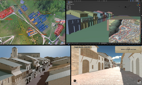
Transforming the Archaeological Record Into a Digital Playground: a Methodological Analysis of The Living Hill ProjectGamification of an archaeological park: The Living Hill Project as work-in-progressRecommended by Sebastian Hageneuer based on reviews by Andrew Reinhard, Erik Champion and 1 anonymous reviewer
This paper (2023) describes The Living Hill project dedicated to the archaeological park and fortress of Poggio Imperiale in Poggibonsi, Italy. The project is a collaboration between the Poggibonsi excavation and Entertainment Games App, Ltd. From the start, the project focused on the question of the intended audience rather than on the used technology. It was therefore planned to involve the audience in the creation of the game itself, which was not possible after all due to the covid pandemic. Nevertheless, the game aimed towards a visit experience as close as possible to reality to offer an educational tool through the video game, as it offers more periods than the medieval period showcased in the archaeological park itself. The game mechanics differ from a walking simulator, or a virtual tour and the player is tasked with returning three lost objects in the virtual game. While the medieval level was based on a 3D scan of the archaeological park, the other two levels were reconstructed based on archaeological material. Currently, only a PC version is working, but the team works on a mobile version as well and teased the possibility that the source code will be made available open source. Lastly, the team also evaluated the game and its perception through surveys, interviews, and focus groups. Although the surveys were only based on 21 persons, the results came back positive overall. The paper is well-written and follows a consistent structure. The authors clearly define the goals and setting of the project and how they developed and evaluated the game. Although it has be criticized that the game is not playable yet and the size of the questionnaire is too low, the authors clearly replied to the reviews and clarified the situation on both matters. They also attended to nearly all of the reviewers demands and answered them concisely in their response. In my personal opinion, I can fully recommend this paper for publication. For future works, it is recommended that the authors enlarge their audience for the quesstionaire in order to get more representative results. It it also recommended to make the game available as soon as possible also outside of the archaeological park. I would also like to thank the reviewers for their concise and constructive criticism to this paper as well as for their time. References Mariotti, Samanta. (2023) Transforming the Archaeological Record Into a Digital Playground: a Methodological Analysis of The Living Hill Project, Zenodo, 8302563, ver. 5 peer-reviewed and recommended by Peer Community in Archaeology https://doi.org/10.5281/zenodo.8302563 | Transforming the Archaeological Record Into a Digital Playground: a Methodological Analysis of *The Living Hill* Project | Samanta Mariotti | <p>Video games are now recognised as a valuable tool for disseminating and enhancing archaeological heritage. In Italy, the recent institutionalisation of Public Archaeology programs and incentives for digital innovation has resulted in a prolifer... | | Conservation/Museum studies, Europe, Medieval, Post-medieval | Sebastian Hageneuer | 2023-08-30 20:25:32 | ||
05 Jun 2023

SEAHORS: Spatial Exploration of ArcHaeological Objects in R ShinyAnalyzing piece-plotted artifacts just got simpler: A good solution to the wrong problem?Recommended by Reuven Yeshurun based on reviews by Frédéric Santos, Jacqueline Meier and Maayan LevPaleolithic archaeologists habitually measure 3-coordinate data for artifacts in their excavations. This was first done manually, and in the last three decades it is usually performed by a total station and associated hardware. While the field recording procedure is quite straightforward, visualizing and analyzing the data are not, often requiring specialized proprietary software or coding expertise. Here, Royer and colleagues (2023) present the SEAHORS application, an elegant solution for the post-excavation analysis of artifact coordinate data that seems to be instantly useful for numerous archaeologists. SEAHORS allows one to import and organize field data (Cartesian coordinates and point description), which often comes in a variety of formats, and to create various density and distribution plots. It is specifically adapted to the needs of archaeologists, is free and accessible, and much simpler to use than many commercial programs. The authors further demonstrate the use of the application in the post-excavation analysis of the Cassenade Paleolithic site (see also Discamps et al., 2019). While in no way detracting from my appreciation of Royer et al.’s (2023) work, I would like to play the devil’s advocate by asking whether, in the majority of cases, field recording of artifacts in three coordinates is warranted. Royer et al. (2023) regard piece plotting as “…indispensable to propose reliable spatial planimetrical and stratigraphical interpretations” but this assertion does not hold in all (or most) cases, where careful stratigraphic excavation employing thin volumetric units would do just as well. Moreover, piece-plotting has some serious drawbacks. The recording often slows excavations considerably, beyond what is needed for carefully exposing and documenting the artifacts in their contexts, resulting in smaller horizontal and vertical exposures (e.g., Gilead, 2002). This typically hinders a fuller stratigraphic and contextual understanding of the excavated levels and features. Even worse, the method almost always creates a biased sample of “coordinated artifacts”, in which the most important items for understanding spatial patterns and site-formation processes – the small ones – are underrepresented. Some projects run the danger of treating the coordinated artifacts as bearing more significance than the sieve-recovered items, preferentially studying the former with no real justification. Finally, the coordinated items often go unassigned to a volumetric unit, effectively disconnecting them from other types of data found in the same depositional contexts. The advantages of piece-plotting may, in some cases, offset the disadvantages. But what I find missing in the general discourse (certainly not in the recommended preprint) is the “theory” behind the seemingly technical act of 3-coordinate recording (Yeshurun, 2022). Being in effect a form of sampling, this practice needs a rethink about where and how to be applied; what depositional contexts justify it, and what the goals are. These questions should determine if all “visible” artifacts are plotted, or just an explicitly defined sample of them (e.g., elongated items above a certain length threshold, which should be more reliable for fabric analysis), or whether the circumstances do not actually justify it. In the latter case, researchers sometimes opt for using “virtual coordinates” within in each spatial unit (typically 0.5x0.5 m), essentially replicating the data that is generated by “real” coordinates and integrating the sieve-recovered items as well. In either case, Royer et al.’s (2023) solution for plotting and visualizing labeled points within intra-site space would indeed be an important addition to the archaeologists’ tool kits.
References cited Discamps, E., Bachellerie, F., Baillet, M. and Sitzia, L. (2019). The use of spatial taphonomy for interpreting Pleistocene palimpsests: an interdisciplinary approach to the Châtelperronian and carnivore occupations at Cassenade (Dordogne, France). Paleoanthropology 2019, 362–388. https://doi.org/10.4207/PA.2019.ART136 Gilead, I. (2002). Too many notes? Virtual recording of artifacts provenance. In: Niccolucci, F. (Ed.). Virtual Archaeology: Proceedings of the VAST Euroconference, Arezzo 24–25 November 2000. BAR International Series 1075, Archaeopress, Oxford, pp. 41–44. Royer, A., Discamps, E., Plutniak, S. and Thomas, M. (2023). SEAHORS: Spatial Exploration of ArcHaeological Objects in R Shiny Zenodo, 7957154, ver. 2 peer-reviewed and recommended by Peer Community in Archaeology. https://doi.org/10.5281/zenodo.7929462 Yeshurun, R. (2022). Intra-site analysis of repeatedly occupied camps: Sacrificing “resolution” to get the story. In: Clark A.E., Gingerich J.A.M. (Eds.). Intrasite Spatial Analysis of Mobile and Semisedentary Peoples: Analytical Approaches to Reconstructing Occupation History. University of Utah Press, pp. 27–35.
| SEAHORS: Spatial Exploration of ArcHaeological Objects in R Shiny | ROYER, Aurélien, DISCAMPS, Emmanuel, PLUTNIAK, Sébastien, THOMAS, Marc | <p style="text-align: justify;">This paper presents SEAHORS, an R shiny application available as an R package, dedicated to the intra-site spatial analysis of piece-plotted archaeological remains. This open-source script generates 2D and 3D scatte... | | Computational archaeology, Spatial analysis, Theoretical archaeology | Reuven Yeshurun | 2023-02-24 16:01:44 | ||
12 Dec 2022
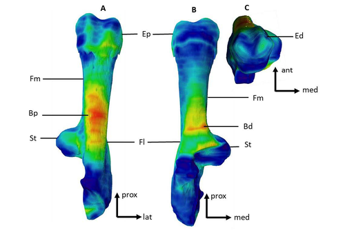
Can growth in captivity alter the calcaneal microanatomy of a wild ungulate?Mobility in pigs: A microanatomical perspectiveRecommended by Nimrod Marom based on reviews by Max Price and Ignacio A. Lazagabaster
Pig domestication and husbandry involved complex processes of introduction, introgression, and feralization that challenge our understanding of human/suid interactions in ancient times. This challenge is a constant stimulus for the development of novel methods and techniques to illuminate aspects of early pig husbandry, such as human-induced changes in mobility. Using geometric morphometrics, Harbers et al. (2020) have shown that the calcaneus records a plastic response to reduced mobility and hence to human management. In the present study, Cottereau et al. (2022) explore the possibility that a similar plastic response to different mobility regimes can be observed in the microanatomy of the calcaneus using CT scans. Their research utilizes a sample of calcanei obtained from Mesolithic specimens, and also from recent suids kept in natural habitat, large pen, and stall. Their results suggest that bone microanatomy is more affected by population differences than by mobility patterns, as illustrated by the similarity between Mesolitic boar calcanei and their difference from recent, free wild boar.
References Cottereau R, Ortiz K, Locatelli Y, Houssaye A, Cucchi T (2022), bioRxiv, 504790, ver. 5 peer-reviewed and recommended by Peer Community in Archaeology. https://doi.org/10.1101/2022.08.22.504790 Harbers H, Neaux D, Ortiz K, Blanc B, Laurens F, Baly I, Callou C, Schafberg R, Haruda A, Lecompte F, Casabianca F, Studer J, Renaud S, Cornette R, Locatelli Y, Vigne J-D, Herrel A, Cucchi T (2020) The mark of captivity: plastic responses in the ankle bone of a wild ungulate (Sus scrofa). Royal Society Open Science, 7, 192039. https://doi.org/10.1098/rsos.192039
| Can growth in captivity alter the calcaneal microanatomy of a wild ungulate? | Romain Cottereau, Katia Ortiz, Yann Locatelli, Alexandra Houssaye*, Thomas Cucchi* | <p style="text-align: justify;">Reduced mobility associated with captivity induce changes in biomechanical stress on the skeleton of domesticated animals. Due to bone plasticity, the morphology and the internal structure of the bones can respond t... | | Neolithic, Zooarchaeology | Nimrod Marom | 2022-08-26 20:29:01 | ||
28 Aug 2023
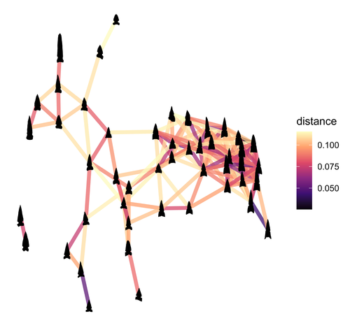
Geometric Morphometric Analysis of Projectile Points from the Southwest United States2D Geometric Morphometrics of Projectile Points from the Southwestern United StatesRecommended by Adrian L. Burke based on reviews by James Conolly and 1 anonymous reviewerBischoff (2023) is a significant contribution to the growing field of geometric morphometric analysis in stone tool analysis. The subject is projectile points from the southwestern United States. Projectile point typologies or systematics remain an important part of North American archaeology, and in fact these typologies continue to be used primarily as cultural-historical markers. This article looks at projectile point types using a 2D image geometric morphometric analysis as a way of both improving on projectile point types but also testing if these types are in fact based in measurable reality. A total of 164 point outlines are analyzed using Elliptical Fourier, semilandmark and landmark analyses. The author also uses a network analysis to look at possible relationships between projectile point morphologies in space. This is a clever way of working around the predefined distributions of projectile point types, some of which are over 100 years old. Because of the dynamic nature of stone tools in terms of their use, reworking and reuse, this article can also provide solutions for studying the dynamic nature of stone tools. This article therefore also has a wide applicability to other stone tool analyses. Reference Bischoff, R. J. (2023) Geometric Morphometric Analysis of Projectile Points from the Southwest United States, SocArXiv, a6wjc, ver. 8 peer-reviewed and recommended by Peer Community in Archaeology. https://doi.org/10.31235/osf.io/a6wjc | Geometric Morphometric Analysis of Projectile Points from the Southwest United States | Robert J. Bischoff | <p style="text-align: justify;">Traditional analyses of projectile points often use visual identification, the presence or absence of discrete characteristics, or linear measurements and angles to classify points into distinct types. Geometric mor... | | Archaeometry, Computational archaeology, Lithic technology, North America | Adrian L. Burke | 2022-12-18 03:38:14 |


