Latest recommendations

| Id | Title | Authors | Abstract | Picture | Thematic fields | Recommender | Reviewers▼ | Submission date | |
|---|---|---|---|---|---|---|---|---|---|
25 Jul 2023
Sorghum and finger millet cultivation during the Aksumite period: insights from ethnoarchaeological modelling and microbotanical analysisAbel Ruiz-Giralt, Alemseged Beldados, Stefano Biagetti, Francesca D’Agostini, A. Catherine D’Andrea, Yemane Meresa, Carla Lancelotti https://doi.org/10.5281/zenodo.7859673An innovative integration of ethnoarchaeological models with phytolith data to study histories of C4 crop cultivationRecommended by Emma Loftus based on reviews by Tanya Hattingh and 1 anonymous reviewerThis article “Sorghum and finger millet cultivation during the Aksumite period: insights from ethnoarchaeological modelling and microbotanical analysis”, submitted by Ruiz-Giralt and colleagues (2023a), presents an innovative attempt to address the lack of palaeobotanical data concerning ancient agricultural strategies in the northern Horn of Africa. In lieu of well-preserved macrobotanical remains, an especial problem for C4 crop species, these authors leverage microbotanical remains (phytoliths), in combination with ethnoarchaeologically-informed agroecology models to investigate finger millet and sorghum cultivation during the period of the Aksumite Kingdom (c. 50 BCE – 800 CE). Both finger millet and sorghum have played important roles in the subsistence of the Horn region, and throughout much of the rest of Africa and the world in the past. The importance of these drought-resistant and adaptable crops is likely to increase as we move into a warmer, drier world. Yet their histories of cultivation are still only approximately sketched due to a paucity of well-preserved remains from archaeological sites - for example, debate continues as to the precise centre of their domestication. Recent studies of phytoliths (by these and other authors) are demonstrating the likely continuous presence of these crops from the pre-Aksumite period. However, phytoliths are diagnostic only to broad taxonomic levels, and cannot be used to securely identify species. To supplement these observations, Ruiz-Giralt et al. deploy models (previously developed by this team: Ruiz-Giralt et al., 2023b) that incorporate environmental variables and ethnographic data on traditional agrosystems. They evaluate the feasibility of different agricultural regimes around the locations of numerous archaeological sites distributed across the highlands of northern Ethiopia and southern Eritrea. Their results indicate the general viability of finger millet and sorghum cultivation around archaeological settlements in the past, with various regions displaying greater-or-lesser suitability at different distances from the site itself. The models also highlight the likelihood of farmers utilising extensive-rainfed regimes, given low water and soil nutrient requirements for these crops. The authors discuss the results with respect to data on phytolith assemblages, particularly at the site of Ona Adi. They conclude that Aksumite agriculture very likely included the cultivation of finger millet and sorghum, as part of a broader system of rainfed cereal cultivation. Ruiz-Giralt et al. argue, and have demonstrated, that ethnoarchaeologically-informed models can be used to generate hypotheses to be evaluated against archaeological data. The integration of many diverse lines of information in this paper certainly enriches the discussion of agricultural possibilities in the past, and the use of a modelling framework helps to formalise the available hypotheses. However, they emphasise that modelling approaches cannot be pursued in lieu of rigorous archaeobotanical studies but only in tandem - a greater commitment to archaeobotanical sampling is required in the region if we are to fully detail the histories of these important crops. References Ruiz-Giralt, A., Beldados, A., Biagetti, S., D’Agostini, F., D’Andrea, A. C., Meresa, Y. and Lancelotti, C. (2023a). Sorghum and finger millet cultivation during the Aksumite period: insights from ethnoarchaeological modelling and microbotanical analysis. Zenodo, 7859673, ver. 3 peer-reviewed and recommended by Peer Community in Archaeology. https://doi.org/10.5281/zenodo.7859673 Ruiz-Giralt, A., Biagetti, S., Madella, M. and Lancelotti, C. (2023b). Small-scale farming in drylands: New models for resilient practices of millet and sorghum cultivation. PLoS ONE 18, e0268120. https://doi.org/10.1371/journal.pone.0268120
| Sorghum and finger millet cultivation during the Aksumite period: insights from ethnoarchaeological modelling and microbotanical analysis | Abel Ruiz-Giralt, Alemseged Beldados, Stefano Biagetti, Francesca D’Agostini, A. Catherine D’Andrea, Yemane Meresa, Carla Lancelotti | <p>For centuries, finger millet (<em>Eleusine coracana</em> Gaertn.) and sorghum (<em>Sorghum bicolor</em> (L.) Moench) have been two of the most economically important staple crops in the northern Horn of Africa. Nonetheless, their agricultural h... | Africa, Archaeobotany, Computational archaeology, Protohistory, Spatial analysis | Emma Loftus | 2023-04-29 16:24:54 | View | ||
02 Sep 2023
Research workflows, paradata, and information visualisation: feedback on an exploratory integration of issues and practices - MEMORIA ISDudek Iwona, Blaise Jean-Yves https://doi.org/10.5281/zenodo.8311129Using information visualisation to improve traceability, transmissibility and verifiability in research workflowsRecommended by Isto Huvila based on reviews by Adéla Sobotkova and 2 anonymous reviewersThe paper “Research workflows, paradata, and information visualisation: feedback on an exploratory integration of issues and practices - MEMORIA IS” (Dudek & Blaise, 2023) describes a prototype of an information system developed to improve the traceability, transmissibility and verifiability of archaeological research workflows. A key aspect of the work with MEMORIA is to make research documentation and the workflows underpinning the conducted research more approachable and understandable using a series of visual interfaces that allow users of the system to explore archaeological documentation, including metadata describing the data and paradata that describes its underlying processes. The work of Dudek and Blaise address one of the central barriers to reproducibility and transparency of research data and propose a set of both theoretically and practically well-founded tools and methods to solve this major problem. From the reported work on MEMORIA IS, information visualisation and the proposed tools emerge as an interesting and potentially powerful approach for a major push in improving the traceability, transmissibility and verifiability of research data through making research workflows easier to approach and understand. In comparison to technical work relating to archaeological data management, this paper starts commendably with a careful explication of the conceptual and epistemic underpinnings of the MEMORIA IS both in documentation research, knowledge organisation and information visualisation literature. Rather than being developed on the basis of a set of opaque assumptions, the meticulous description of the MEMORIA IS and its theoretical and technical premises is exemplary in its transparence and richness and has potential for a long-term impact as a part of the body of literature relating to the development of archaeological documentation and documentation tools. While the text is sometimes fairly densely written, it is worth taking the effort to read it through. Another major strength of the paper is that it provides a rich set of examples of the workings of the prototype system that makes it possible to develop a comprehensive understanding of the proposed approaches and assess their validity. As a whole, this paper and the reported work on MEMORIA IS forms a worthy addition to the literature on and practical work for developing critical infrastructures for data documentation, management and access in archaeology. Beyond archaeology and the specific context of the discussed work discussed this paper has obvious relevance to comparable work in other fields. ReferencesDudek, I. and Blaise, J.-Y. (2023) Research workflows, paradata, and information visualisation: feedback on an exploratory integration of issues and practices - MEMORIA IS, Zenodo, 8252923, ver. 3 peer-reviewed and recommended by Peer Community in Archaeology. https://doi.org/10.5281/zenodo.8252923
| Research workflows, paradata, and information visualisation: feedback on an exploratory integration of issues and practices - MEMORIA IS | Dudek Iwona, Blaise Jean-Yves | <p>The paper presents an exploratory web information system developed as a reaction to practical and epistemological questions, in the context of a scientific unit studying the architectural heritage (from both historical sciences perspective, and... |  | Computational archaeology | Isto Huvila | 2023-05-02 12:50:39 | View | |
12 Feb 2024
3Duewelsteene - A website for the 3D visualization of the megalithic passage grave Düwelsteene near Heiden in Westphalia, GermanyTharandt, Louise https://doi.org/10.5281/zenodo.7948379Online presentation of the digital reconstruction process of a megalithic tomb : “3Duewelsteene”Recommended by Sophie C. Schmidt and James Allison based on reviews by Robert Bischoff, Ronald Visser and Scott Ure based on reviews by Robert Bischoff, Ronald Visser and Scott Ure
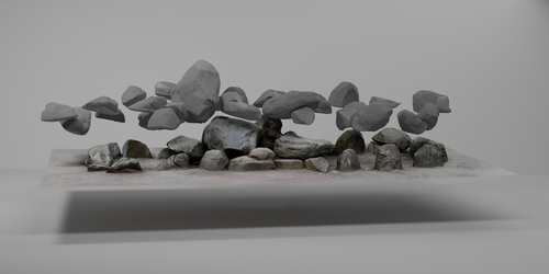
“3Duewelsteene - A website for the 3D visualization of the megalithic passage grave Düwelsteene near Heiden in Westphalia, Germany” (Tharandt 2024) presents several 3-dimensional models of the Düwelsteene monument, along with contextual information about the grave and the process of creating the models. The website (https://3duewelsteene.github.io/) includes English and German versions, making it accessible to a wide audience. The website itself serves as the primary means of presenting the data, rather than as a supplement to a written text. This is an innovative and engaging way to present the research to a wider public. Düwelsteene (“Devil’s Stones”) is a megalithic passage grave from the Funnel Beaker culture, dating to approximately 3300 BC. to 2600 BC. that was excavated in 1932. The website displays three separate 3-dimensional models. They ares shown in the 3D viewer software 3DHOP, which enables viewers to interact with the models in several ways, Annotations on the models display further information. The first model was created by image-based modeling and shows the monument as it appears today. A second model uses historical photographs and excavation data to reconstruct the grave as it appeared prior to the 1932 archaeological excavation. Restoration work following the excavation relocated many of the stones. Pre-1932 photographs collected from residents of the nearby town of Heiden were then used to create a model showing what the tomb looked like before the restoration work. It is commendable that a “certainty view” of the model shows the certainty with which the stones can be put at the reconstructed place. Gaps in the 3D models of stones that were caused by overlap with other stones have been filled with a rough mesh and marked as such, thereby differentiating between known and unknown parts of the stones. The third model is the most imaginative and most interesting. As it shows as the grave as it might have appeared in approximately 3000 B.C., many aspects of this model are necessarily somewhat speculative. There is no direct evidence for exact size and shape of the capstones, the height of the mound, and other details. But enough is known about other similar constructions to allow these details to be inferred with some confidence. Again, care was taken to enable viewers to distinguish between the stones that are still in existence and those that were reconstructed. A video on the home page of the website adds a nice touch. It starts with the model of the Düwelsteene as it currently appears then shows, in reverse order, the changes to the grave, ending with the inferred original state. The 3D reconstructions are convincing and the methods well described. This project follows an open science approach and the FAIR principles, which is commendable and cutting edge in the field of Digital Archaeology. The preprint of the website hosted on zenodo includes all the photos, text, html files, and nine individual 3D model (.ply) files that are combined in the reconstructions exhibited on the website. A “readme.md” file includes details about building the models using CloudCompare and Blender, and modifications to the 3D viewer software (3DHOP) to get the website to improve the display of the reconstructions. We have to note that the link between the reconstructed models and the html page does not work when the files are downloaded from zenodo and opened offline. The html pages open in the browser, and the individual ply files work fine, but the 3D models do not display on the browser page when the html files are opened offline. The online version of the website is working perfectly. The 3Düwelsteene website combines the presentation of archaeological domain knowledge to a lay audience as well as in-depths information on the reconstruction process to make it an interesting contribution for researchers. By providing data and code for the website it also models an Open Science approach, which enables other researchers to re-use these materials. We congratulate the author on a successful reconstruction of the megalithic tomb, an admirable presentation of the archaeological work and the thoughtful outreach to a broad audience. Bibliography | 3Duewelsteene - A website for the 3D visualization of the megalithic passage grave Düwelsteene near Heiden in Westphalia, Germany | Tharandt, Louise | <p>The Düwelsteene near Heiden, Westphalia, is one of the most southern megalithic tombs of the Funnel Beaker culture. In 1932 the Düwelsteene were restored and the appearance of the grave was changed. Even though the megalithic tomb was excavated... |  | Computational archaeology, Mesolithic, Neolithic | Sophie C. Schmidt | 2023-05-21 17:24:22 | View | |
02 Sep 2023
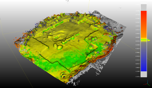
Towards a Mobile 3D Documentation Solution. Video Based Photogrammetry and iPhone 12 Pro as Fieldwork Documentation ToolsNikolai Paukkonen https://doi.org/10.5281/zenodo.7954534The Potential of Mobile 3D Documentation using Video Based Photogrammetry and iPhone 12 ProRecommended by Ying Tung Fung based on reviews by Dominik Hagmann, Sebastian Hageneuer and 1 anonymous reviewerI am pleased to recommend the paper titled "Towards a Mobile 3D Documentation Solution. Video Based Photogrammetry and iPhone 12 Pro as Fieldwork Documentation Tools" for consideration and publication as a preprint (Paukkonen, 2023). The paper addresses a timely and relevant topic within the field of archaeology and offers valuable insights into the evolving landscape of 3D documentation methods. The advances in technology over the past decade have brought about significant changes in archaeological documentation practices. This paper makes a valuable contribution by discussing the emergence of affordable equipment suitable for 3D fieldwork documentation. Given the constraints that many archaeologists face with limited resources and tight timeframes, the comparison between photogrammetry based on a video captured by a DJI Osmo Pocket gimbal camera and iPhone 12 Pro LiDAR scans is of great significance. The research presented in the paper showcases a practical application of these new technologies in the context of a Finnish Early Modern period archaeological project. By comparing the acquisition processes and evaluating the accuracy, precision, ease of use, and time constraints associated with each method, the authors provide a comprehensive assessment of their potential for archaeological fieldwork. This practical approach is a commendable aspect of the paper, as it not only explores the technical aspects but also considers the practical implications for archaeologists on the ground. Furthermore, the paper appropriately addresses the limitations of these technologies, specifically highlighting their potential inadequacy for projects requiring a higher level of precision, such as Neolithic period excavations. This nuanced perspective adds depth to the discussion and provides a realistic portrayal of the strengths and limitations of the new documentation methods. In conclusion, the paper offers valuable insights into the future of 3D field documentation for archaeologists. The authors' thorough evaluation and practical approach make this study a valuable resource for researchers, practitioners, and professionals in the field. I believe that this paper would be an excellent addition to PCIArchaeology and would contribute significantly to the ongoing dialogue within the archaeological community. References Paukkonen, N. (2023) Towards a Mobile 3D Documentation Solution. Video Based Photogrammetry and iPhone 12 Pro as Fieldwork Documentation Tools, Zenodo, 8281263, ver. 3 peer-reviewed and recommended by Peer Community in Archaeology. https://doi.org/10.5281/zenodo.8281263 | Towards a Mobile 3D Documentation Solution. Video Based Photogrammetry and iPhone 12 Pro as Fieldwork Documentation Tools | Nikolai Paukkonen | <p>New affordable equipment suitable for 3D fieldwork documentation has appeared during the last years. Both photogrammetry and laser scanning are becoming affordable for archaeologists, who often work with limited resources and tight time constra... |  | Europe, Post-medieval, Remote sensing | Ying Tung Fung | 2023-05-21 21:32:33 | View | |
23 Nov 2023
Percolation Package - From script sharing to package publicationSophie C Schmidt; Simon Maddison https://doi.org/10.5281/zenodo.7966497Sharing Research Code in ArchaeologyRecommended by James Allison based on reviews by Thomas Rose, Joe Roe and 1 anonymous reviewer based on reviews by Thomas Rose, Joe Roe and 1 anonymous reviewer
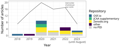
The paper “Percolation Package – From Script Sharing to Package Publication” by Sophie C. Schmidt and Simon Maddison (2023) describes the development of an R package designed to apply Percolation Analysis to archaeological spatial data. In an earlier publication, Maddison and Schmidt (2020) describe Percolation Analysis and provide case studies that demonstrate its usefulness at different spatial scales. In the current paper, the authors use their experience collaborating to develop the R package as part of a broader argument for the importance of code sharing to the research process. The paper begins by describing the development process of the R package, beginning with borrowing code from a geographer, refining it to fit archaeological case studies, and then collaborating to further refine and systematize the code into an R package that is more easily reusable by other researchers. As the review by Joe Roe noted, a strength of the paper is “presenting the development process as it actually happens rather than in an idealized form.” The authors also include a section about the lessons learned from their experience. Moving on from the anecdotal data of their own experience, the authors also explore code sharing practices in archaeology by briefly examining two datasets. One dataset comes from “open-archaeo” (https://open-archaeo.info/), an on-line list of open-source archaeological software maintained by Zack Batist. The other dataset includes articles published between 2018 and 2023 in the Journal of Computer Applications in Archaeology. Schmidt and Maddison find that these two datasets provide contrasting views of code sharing in archaeology: many of the resources in the open-archaeo list are housed on Github, lack persistent object identifiers, and many are not easily findable (other than through the open-archaeo list). Research software attached to the published articles, on the other hand, is more easily findable either as a supplement to the published article, or in a repository with a DOI. The examination of code sharing in archaeology through these two datasets is preliminary and incomplete, but it does show that further research into archaeologists’ code-writing and code-sharing practices could be useful. Archaeologists often create software tools to facilitate their research, but how often? How often is research software shared with published articles? How much attention is given to documentation or making the software usable for other researchers? What are best (or good) practices for sharing code to make it findable and usable? Schmidt and Maddison’s paper provides partial answers to these questions, but a more thorough study of code sharing in archaeology would be useful. Differences among journals in how often they publish articles with shared code, or the effects of age, gender, nationality, or context of employment on attitudes toward code sharing seem like obvious factors for a future study to consider. Shared code that is easy to find and easy to use benefits the researchers who adopt code written by others, but code authors also have much to gain by sharing. Properly shared code becomes a citable research product, and the act of code sharing can lead to productive research collaborations, as Schmidt and Maddison describe from their own experience. The strength of this paper is the attention it brings to current code-sharing practices in archaeology. I hope the paper will also help improve code sharing in archaeology by inspiring more archaeologists to share their research code so other researchers can find and use (and cite) it. References Maddison, M.S. and Schmidt, S.C. (2020). Percolation Analysis – Archaeological Applications at Widely Different Spatial Scales. Journal of Computer Applications in Archaeology, 3(1), p.269–287. https://doi.org/10.5334/jcaa.54 Schmidt, S. C., and Maddison, M. S. (2023). Percolation Package - From script sharing to package publication, Zenodo, 7966497, ver. 3 peer-reviewed and recommended by Peer Community in Archaeology. https://doi.org/10.5281/zenodo.7966497 | Percolation Package - From script sharing to package publication | Sophie C Schmidt; Simon Maddison | <p>In this paper we trace the development of an R-package starting with the adaptation of code from a different field, via scripts shared between colleagues, to a published package that is being successfully used by researchers world-wide. Our aim... |  | Computational archaeology | James Allison | 2023-05-24 15:40:15 | View | |
06 Aug 2023
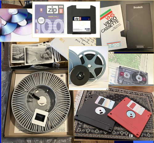
A Focus on the Future of our Tiny Piece of the Past: Digital Archiving of a Long-term Multi-participant Regional ProjectScott Madry, Gregory Jansen, Seth Murray, Elizabeth Jones, Lia Willcoxon, Ebtihal Alhashem https://doi.org/10.5281/zenodo.7967035A meticulous description of archiving research data from a long-running landscape research projectRecommended by Isto Huvila based on reviews by Dominik Hagmann and Iwona DudekThe paper “A Focus on the Future of our Tiny Piece of the Past: Digital Archiving of a Long-term Multi-participant Regional Project” (Madry et al., 2023) describes practices, challenges and opportunities encountered in digital archiving of a landscape research project running in Burgundy, France for more than 45 years. As an unusually long-running multi-disciplinary undertaking working with a large variety of multi-modal digital and non-digital data, the Burgundy project has lived through the development of documentation and archiving technologies from the 1970s until today and faced many of the challenges relating to data management, preservation and migration. The major strenght of the paper is that it provides a detailed description of the evolution of digital data archiving practices in the project including considerations about why some approaches were tested and abandoned. This differs from much of the earlier literature where it has been more common to describe individual solutions how digital archiving was either planned or was performed at one point of time. A longitudinal description of what was planned, how and why it has worked or failed so far, as described in the paper, provides important insights in the everyday hurdles and ways forward in digital archiving. As a description of a digital archiving initiative, the paper makes a valuable contribution for the data archiving scholarship as a case description of practices and considerations in one research project. For anyone working with data management in a research project either as a researcher or data manager, the text provides useful advice on important practical matters to consider ahead, during and after the project. The main advice the authors are giving, is to plan and act for data preservation from the beginning of the project rather than doing it afterwards. To succeed in this, it is crucial to be knowledgeable of the key concepts of data management—such as “digital data fixity, redundant backups, paradata, metadata, and appropriate keywords” as the authors underline—including their rationale and practical implications. The paper shows also that when and if unexpected issues raise, it is important to be open for different alternatives, explore ways forward, and in general be flexible. The paper makes also a timely contribution to the discussion started at the session “Archiving information on archaeological practices and work in the digital environment: workflows, paradata and beyond” at the Computer Applications and Quantitative 2023 conference in Amsterdam where it was first presented. It underlines the importance of understanding and communicating the premises and practices of how data was collected (and made) and used in research for successful digital archiving, and the similar pertinence of documenting digital archiving processes to secure the keeping, preservation and effective reuse of digital archives possible. ReferencesMadry, S., Jansen, G., Murray, S., Jones, E., Willcoxon, L. and Alhashem, E. (2023) A Focus on the Future of our Tiny Piece of the Past: Digital Archiving of a Long-term Multi-participant Regional Project, Zenodo, 7967035, ver. 3 peer-reviewed and recommended by Peer Community in Archaeology. https://doi.org/10.5281/zenodo.7967035 | A Focus on the Future of our Tiny Piece of the Past: Digital Archiving of a Long-term Multi-participant Regional Project | Scott Madry, Gregory Jansen, Seth Murray, Elizabeth Jones, Lia Willcoxon, Ebtihal Alhashem | <p>This paper will consider the practical realities that have been encountered while seeking to create a usable Digital Archiving system of a long-term and multi-participant research project. The lead author has been involved in archaeologic... |  | Computational archaeology, Environmental archaeology, Landscape archaeology | Isto Huvila | 2023-05-24 18:46:34 | View | |
31 Jan 2024
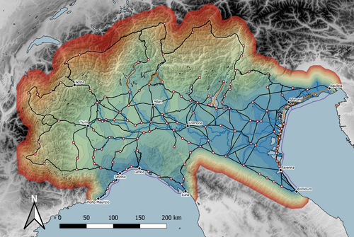
Rivers vs. Roads? A route network model of transport infrastructure in Northern Italy during the Roman periodJames Page https://zenodo.org/records/7971399Modelling Roman Transport Infrastructure in Northern ItalyRecommended by Andrew McLean based on reviews by Pau de Soto and Adam PažoutStudies of the economy of the Roman Empire have become increasingly interdisciplinary and nuanced in recent years, allowing the discipline to make great strides in data collection and importantly in the methods through which this increasing volume of data can be effectively and meaningfully analysed [see for example 1 and 2]. One of the key aspects of modelling the ancient economy is understanding movement and transport costs, and how these facilitated trade, communication and economic development. With archaeologists adopting more computational techniques and utilising GIS analysis beyond simply creating maps for simple visualisation, understanding and modelling the costs of traversing archaeological landscapes has become a much more fruitful avenue of research. Classical archaeologists are often slower to adopt these new computational techniques than others in the discipline. This is despite (or perhaps due to) the huge wealth of data available and the long period of time over which the Roman economy developed, thrived and evolved. This all means that the Roman Empire is a particularly useful proving ground for testing and perfecting new methodological developments, as well as being a particularly informative period of study for understanding ancient human behaviour more broadly. This paper by Page [3] then, is well placed and part of a much needed and growing trend of Roman archaeologists adopting these computational approaches in their research. Page’s methodology builds upon De Soto’s earlier modelling of transport costs [4] and applies it in a new setting. This reflects an important practice which should be more widely adopted in archaeology. That of using existing, well documented methodologies in new contexts to offer wider comparisons. This allows existing methodologies to be perfected and tested more robustly without reinventing the wheel. Page does all this well, and not only builds upon De Soto’s work, but does so using a case study that is particularly interesting with convincing and significant results. As Page highlights, Northern Italy is often thought of as relatively isolated in terms of economic exchange and transport, largely due to the distance from the sea and the barriers posed by the Alps and Apennines. However, in analysing this region, and not taking such presumptions for granted, Page quite convincingly shows that the waterways of the region played an important role in bringing down the cost of transport and allowed the region to be far more interconnected with the wider Roman world than previous studies have assumed. This article is clearly a valuable and important contribution to our understanding of computational methods in archaeology as well as the economy and transport network of the Roman Empire. The article utilises innovative techniques to model transport in an area of the Roman Empire that is often overlooked, with the economic isolation of the area taken for granted. Having high quality research such as this specifically analysing the region using the most current methodologies is of great importance. Furthermore, developing and improving methodologies like this allow for different regions and case studies to be analysed and directly compared, in a way that more traditional analyses simply cannot do. As such, Page has demonstrated the importance of reanalysing traditional assumptions using the new data and analyses now available to archaeologists. References [1] Brughmans, T. and Wilson, A. (eds.) (2022). Simulating Roman Economies: Theories, Methods, and Computational Models. Oxford. [2] Dodd, E.K. and Van Limbergen, D. (eds.) (2024). Methods in Ancient Wine Archaeology: Scientific Approaches in Roman Contexts. London ; New York. [3] Page, J. (2024). Rivers vs. Roads? A route network model of transport infrastructure in Northern Italy during the Roman period, Zenodo, 7971399, ver. 3 peer-reviewed and recommended by Peer Community in Archaeology. https://doi.org/10.5281/zenodo.7971399 [4] De Soto P (2019). Network Analysis to Model and Analyse Roman Transport and Mobility. In: Finding the Limits of the Limes. Modelling Demography, Economy and Transport on the Edge of the Roman Empire. Ed. by Verhagen P, Joyce J, and Groenhuijzen M. Springer Open Access, pp. 271–90. https://doi.org/10.1007/978-3-030-04576-0_13 | Rivers vs. Roads? A route network model of transport infrastructure in Northern Italy during the Roman period | James Page | <p>Northern Italy has often been characterised as an isolated and marginal area during the Roman period, a region constricted by mountain ranges and its distance from major shipping lanes. Historians have frequently cited these obstacles, alongsid... |  | Classic, Computational archaeology | Andrew McLean | 2023-05-28 15:11:31 | View | |
29 Aug 2023
Designing Stories from the Grave: Reviving the History of a City through Human Remains and Serious GamesTsaknaki, Electra; Anastasovitis, Eleftherios; Georgiou, Georgia; Alagialoglou, Kleopatra; Mavrokostidou, Maria; Kartsiakli, Vasiliki; Aidonis, Asterios; Protopsalti, Tania; Nikolopoulos, Spiros; Kompatsiaris, Ioannis https://doi.org/10.5281/zenodo.7981323AR and VR Gamification as a proof-of-conceptRecommended by Sebastian Hageneuer based on reviews by Sophie C. Schmidt and Tine Rassalle based on reviews by Sophie C. Schmidt and Tine Rassalle
Tsaknaki et al. (2023) discuss a work-in-progress project in which the presentation of Cultural Heritage is communicated using Serious Games techniques in a story-centric immersive narration instead of an exhibit-centered presentation with the use of Gamification, Augmented and Virtual Reality technologies. In the introduction the authors present the project called ECHOES, in which knowledge about the past of Thessaloniki, Greece is planned to be processed as an immersive and interactive experience. After presenting related work and the methodology, the authors describe the proposed design of the Serious Game and close the article with a discussion and conclusions. The paper is interesting because it highlights an ongoing process in the realm of the visualization of Cultural Heritage (see for example Champion 2016). The process described by the authors on how to accomplish this by using Serious Games, Gamification, Augmented and Virtual Reality is promising, although still hypothetical as the project is ongoing. It remains to be seen if the proposed visuals and interactive elements will work in the way intended and offer users an immersive experience after all. A preliminary questionnaire already showed that most of the respondents were not familiar with these technologies (AR, VR) and in my experience these numbers only change slowly. One way to overcome the technological barrier however might be the gamification of the experience, which the authors are planning to implement. I decided to recommend this article based on the remarks of the two reviewers, which the authors implemented perfectly, as well as my own evaluation of the paper. Although still in progress it seems worthwhile to have this article as a basis for discussion and comparison to similar projects. However, the article did not mention the possible longevity of data and in which ways the usability of the Serious Game will be secured for long-term storage. One eminent problem in these endeavors is, that we can read about these projects, but never find them anywhere to test them ourselves (see for example Gabellone et al. 2016). It is my intention with this review and the recommendation, that the ECHOES project will find a solution for this problem and that we are not only able to read this (and forthcoming) article(s) about the ECHOES project, but also play the Serious Game they are proposing in the near and distant future. References
Gabellone, Francesco, Antonio Lanorte, Nicola Masini, und Rosa Lasaponara. 2016. „From Remote Sensing to a Serious Game: Digital Reconstruction of an Abandoned Medieval Village in Southern Italy“. Journal of Cultural Heritage. https://doi.org/10.1016/j.culher.2016.01.012 Tsaknaki, Electra, Anastasovitis, Eleftherios, Georgiou, Georgia, Alagialoglou, Kleopatra, Mavrokostidou, Maria, Kartsiakli, Vasiliki, Aidonis, Asterios, Protopsalti, Tania, Nikolopoulos, Spiros, and Kompatsiaris, Ioannis. (2023). Designing Stories from the Grave: Reviving the History of a City through Human Remains and Serious Games, Zenodo, 7981323, ver. 4 peer-reviewed and recommended by Peer Community in Archaeology. https://doi.org/10.5281/zenodo.7981323 | Designing Stories from the Grave: Reviving the History of a City through Human Remains and Serious Games | Tsaknaki, Electra; Anastasovitis, Eleftherios; Georgiou, Georgia; Alagialoglou, Kleopatra; Mavrokostidou, Maria; Kartsiakli, Vasiliki; Aidonis, Asterios; Protopsalti, Tania; Nikolopoulos, Spiros; Kompatsiaris, Ioannis | <p>The main challenge of the current digital transition is to utilize computing media and cutting-edge technologyin a more meaningful way, which would make the archaeological and anthropological research outcomes relevant to a heterogeneous audien... |  | Bioarchaeology, Computational archaeology, Europe | Sebastian Hageneuer | 2023-05-29 13:19:46 | View | |
05 Jan 2024
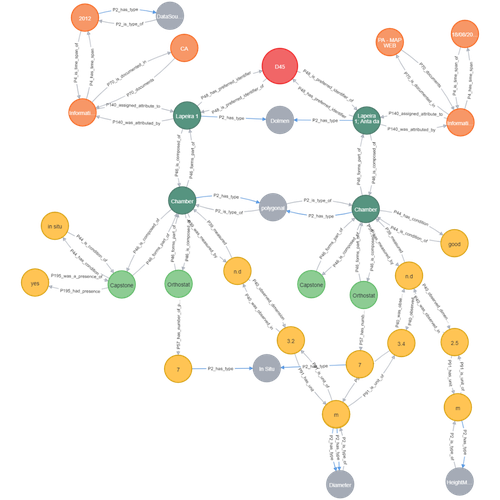
Transforming the CIDOC-CRM model into a megalithic monument property graphAriele Câmara, Ana de Almeida, João Oliveira https://doi.org/10.5281/zenodo.7981230Informative description of a project implementing a CIDOC-CRM based native graph database for representing megalithic informationRecommended by Isto Huvila based on reviews by 2 anonymous reviewersThe paper “Transforming the CIDOC-CRM model into a megalithic monument property graph” describes an interesting endeavour of developing and implementing a CIDOC-CRM based knowledge graph using a native graph database (Neo4J) to represent megalithic information (Câmara et al. 2023). While there are earlier examples of using native graph databases and CIDOC-CRM in diverse heritage contexts, the present paper is useful addition to the literature as a detailed description of an implementation in the context of megalithic heritage. The paper provides a demonstration of a working implementation, and guidance for future projects. The described project is also documented to an extent that the paper will open up interesting opportunities to compare the approach to previous and forthcoming implementations. The same applies to the knowledge graph and use of CIDOC-CRM in the project. Readers interested in comparing available technologies and those who are developing their own knowledge graphs might have benefited of a more detailed description of the work in relation to the current state-of-the-art and what the use of a native graph database in the built-heritage contexts implies in practice for heritage documentation beyond that it is possible and it has potentially meaningful performance-related advantages. While also the reasons to rely on using plain CIDOC-CRM instead of extensions could have been discussed in more detail, the approach demonstrates how the plain CIDOC-CRM provides a good starting point to satisfy many heritage documentation needs. As a whole, the shortcomings relating to positioning the work to the state-of-the-art and reflecting and discussing design choices do not reduce the value of the paper as a valuable case description for those interested in the use of native graph databases and CIDOC-CRM in heritage documentation in general and the documentation of megalithic heritage in particular. ReferencesCâmara, A., de Almeida, A. and Oliveira, J. (2023). Transforming the CIDOC-CRM model into a megalithic monument property graph, Zenodo, 7981230, ver. 4 peer-reviewed and recommended by Peer Community in Archaeology. https://doi.org/10.5281/zenodo.7981230 | Transforming the CIDOC-CRM model into a megalithic monument property graph | Ariele Câmara, Ana de Almeida, João Oliveira | <p>This paper presents a method to store information about megalithic monuments' building components as graph nodes in a knowledge graph (KG). As a case study we analyse the dolmens from the region of Pavia (Portugal). To build the KG, information... |  | Computational archaeology | Isto Huvila | 2023-05-29 13:46:49 | View | |
29 Jan 2024
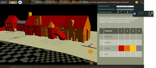
Visual encoding of a 3D virtual reconstruction's scientific justification: feedback from a proof-of-concept researchJ.Y Blaise, I.Dudek, L.Bergerot, G.Simon https://zenodo.org/record/79831633D Models, Knowledge and Visualization: a prototype for 3D virtual models according to plausible criteriaRecommended by Daniel Carvalho based on reviews by Robert Bischoff and Louise TharandtThe construction of 3D realities is deeply embedded in archaeological practices. From sites to artifacts, archaeology has dedicated itself to creating digital copies for the most varied purposes. The paper “Visual encoding of a 3D virtual reconstruction's 3 scientific justification: feedback from a proof-of-concept research” (Jean-Yves et al 2024) represents an advance, in the sense that it does not just deal with a three-dimensional theory for archaeological practice, but rather offers proposals regarding the epistemic component, how it is possible to represent knowledge through the workflow of 3D virtual reconstructions themselves. The authors aim to unite three main axes - knowledge modeling, visual encoding and 3D content reuse - (Jean-Yves et al 2024: 2), which, for all intents and purposes, form the basis of this article. With regard to the first aspect, this work questions how it is possible to transmit the knowledge we want to a 3D model and how we can optimize this epistemic component. A methodology based on plausibility criteria is offered, which, for the archaeological field, offers relevant space for reflection. Given our inability to fully understand the object or site that is the subject of the 3D representation, whether in space or time, building a method based on probabilistic categories is probably one of the most realistic approaches to the realities of the past. Thus, establishing a plausibility criterion allows the user to question the knowledge that is transmitted through the representation, and can corroborate or refute it in future situations. This is because the role of reusing these models is of great interest to the authors, a perfectly justifiable sentiment, as it encourages a critical view of scientific practices. Visual encoding is, in terms of its conjunction with knowledge practices, a key element. The notion of simplicity under Maeda's (2006) design principles not only represents a way of thinking that favors operability, but also a user-friendly design in the prototype that the authors have created. This is also visible when it comes to the reuse of parts of the models, in a chronological logic: adapting the models based on architectural elements that can be removed or molded is a testament to intelligent design, whereby instead of redoing models in their entirety, they are partially used for other purposes. All these factors come together in the final prototype, a web application that combines relational databases (RDBMS) with a data mapper (MassiveJS), using the PHP programming language. The example used is the Marmoutier Abbey hostelry, a centuries-old building which, according to the sources presented, has evolved architecturally over several centuries ((Jean-Yves et al 2024: 8). These states of the building are represented visually through architectural elements based on their existence, location, shape and size, always in terms of what is presented as being plausible. This allows not only the creation of a matrix in which various categories are related to various architectural elements, but also a visual aid, through a chromatic spectrum, of the plausibility that the authors are aiming for. In short, this is an article that seeks to rethink the degree of knowledge we can obtain through 3D visualizations and that does not take models as static, but rather realities that must be explored, recycled and reinterpreted in the light of different data, users and future research. For this reason, it is a work of great relevance to theoretical advances in 3D modeling adapted to archaeology.
References Blaise, J.-Y., Dudek, I., Bergerot, L. and Gaël, S. (2024). Visual encoding of a 3D virtual reconstruction's scientific justification: feedback from a proof-of-concept research, Zenodo, 7983163, ver. 3 peer-reviewed and recommended by Peer Community in Archaeology. https://doi.org/10.5281/zenodo.10496540 John Maeda. (2006). The Laws of Simplicity. MIT Press, Cambridge, MA, USA. | Visual encoding of a 3D virtual reconstruction's scientific justification: feedback from a proof-of-concept research | J.Y Blaise, I.Dudek, L.Bergerot, G.Simon | <p> 3D virtual reconstructions have become over the last decades a classical mean to communicate about analysts’ visions concerning past stages of development of an edifice or a site. However, they still today remain quite often a one-s... |  | Computational archaeology, Spatial analysis | Daniel Carvalho | 2023-05-30 00:43:03 | View |
MANAGING BOARD
Alain Queffelec
Marta Arzarello
Ruth Blasco
Otis Crandell
Luc Doyon
Sian Halcrow
Emma Karoune
Aitor Ruiz-Redondo
Philip Van Peer


