
Latest recommendations

| Id | Title | Authors | Abstract | Picture▼ | Thematic fields | Recommender | Reviewers | Submission date | |
|---|---|---|---|---|---|---|---|---|---|
16 Apr 2024
Creating an Additional Class Layer with Machine Learning to counter Overfitting in an Unbalanced Ancient Coin DatasetA significant contribution to the problem of unbalanced data in machine learning research in archaeologyRecommended by Alex Brandsen based on reviews by Simon Carrignon, Joel Santos and 1 anonymous reviewer based on reviews by Simon Carrignon, Joel Santos and 1 anonymous reviewer
This paper [1] presents an innovative approach to address the prevalent challenge of unbalanced datasets in coin type recognition, shifting the focus from coin class type recognition to coin mint recognition. Despite this shift, the issue of unbalanced data persists. To mitigate this, the authors introduce a method to split larger classes into smaller ones, integrating them into an 'additional class layer'. Three distinct machine learning (ML) methodologies were employed to identify new possible classes, with one approach utilising unsupervised clustering alongside manual intervention, while the others leverage object detection, and Natural Language Processing (NLP) techniques. However, despite these efforts, overfitting remained a persistent issue, prompting the authors to explore alternative methods such as dataset improvement and Generative Adversarial Networks (GANs). The paper contributes significantly to the intersection of ML techniques and archaeology, particularly in addressing overfitting challenges. Furthermore, the authors' candid acknowledgment of the limitations of their approaches serves as a valuable resource for researchers encountering similar obstacles. This study stems from the D4N4 project, aimed at developing a machine learning-based coin recognition model for the extensive "Corpus Nummorum" dataset, comprising over 19,600 coin types and 49,000 coins from various ancient landscapes. Despite encountering challenges with overfitting due to the dataset's imbalance, the authors' exploration of multiple methodologies and transparent documentation of their limitations enriches the academic discourse and provides a foundation for future research in this field. Reference [1] Gampe, S. and Tolle, K. (2024). Creating an Additional Class Layer with Machine Learning to counter Overfitting in an Unbalanced Ancient Coin Dataset. Zenodo, 8298077, ver. 4 peer-reviewed and recommended by Peer Community in Archaeology. https://doi.org/10.5281/zenodo.8298077 | Creating an Additional Class Layer with Machine Learning to counter Overfitting in an Unbalanced Ancient Coin Dataset | Sebastian Gampe, Karsten Tolle | <p>We have implemented an approach based on Convolutional Neural Networks (CNN) for mint recognition for our Corpus Nummorum (CN) coin dataset as an alternative to coin type recognition, since we had too few instances for most of the types (classe... | | Computational archaeology | Alex Brandsen | 2023-08-29 16:26:41 | ||
05 Jan 2024
The Density of Types and the Dignity of the Fragment. A Website Approach to Archaeological Typology.Roster and Lexicon – A Radical Digital-Dialogical Approach to Questions of Typology and Categorization in ArchaeologyRecommended by Shumon Tobias Hussain, Felix Riede and Sébastien Plutniak based on reviews by Dominik Hagmann and 2 anonymous reviewers
“The density of types and the dignity of the fragment. A website approach to archaeological typology” by G. Buccellati and M. Kelly-Buccellati (1) is a contribution to the rapidly growing literature on digital approaches to archaeological data management, expertly showcasing the significant theoretical and epistemological impetus of such work. The authors offer a conceptually lucid discussion of key concepts in archaeological ordering practices surrounding the longstanding tension between so-called ‘etic’ and ‘emic’ approaches, thereby providing a thorough systematic of how to think through sameness and difference in the context of voluminous digital archaeological data. As a point of departure, the authors reconsider the relationship between archaeological fragments – spatiotemporally bounded artefacts and features – and their larger meaning-giving totality as the primary locus of archaeological knowledge. Typology can then be said to serve this overriding quest to resolve the conflict between parts and wholes, as the parts themselves are never sufficient to render the whole but the whole remains elusive without reference to the parts. Buccellati and Kelly-Buccellati here make an interesting point about the importance to register the globality of the archaeological record – that is, literally everything encountered in the soil – without making any prior choices as to what supposedly matters and what not. The distinctiveness of the archaeological enterprise, according to them, indeed consists of the circumstance that merely disconnected fragments come to the attention of archaeologists and the only objective data that can be attained, because of this, are about the situated location of fragments in the ground and their relation to other fragments – what they call ‘emplacement’. This, we would add, includes the relationship of fragments with human observers and the employed methods of excavation as observation. As the authors say: “[i]t is in this sense that the fragments are natively digital: they are atoms that do not cohere into a typological whole”. The systematic exploration of how the so recovered fragments may be re-articulated is then essentially the goal of archaeological categorization and typology but these practices can only ever be successful if the whole context of original ‘emplacement’ is carefully taken into consideration. This reconstruction of the fundamental epistemological situation archaeology finds itself in leads the authors to a general rejection of ‘more’ vs. ‘less’ objective or even subjective ordering practices as such qualifications tend to miss the point. What matters is to enable the flexible and scalable confrontation of isolated archaeological fragments, to do experiment with and test different part-whole relations and their possible knowledge contributions. It is no coincidence that the authors insist on a dynamical approach to ordering practices and type-thinking in archaeology here, which in many ways comes often very close to the general conceptual orientation philosopher Stephen C. Pepper (2) has called ‘organicism’ – a preoccupation of resolving the tension between heterogeneous fragments and coherent wholes without losing sight of the specificity of each single fragment. In the view of organicist thinkers, and the authors seem to share this recognition, to take complexity seriously means to centre the dialectics between fragments and wholes in their entirety. This notion is directly reflected in the authors’ interesting definition of ‘big data’ in archaeology as a multi-layered and multi-referential system of organizing the totality of observations of emplacement (the Global record). Based on this broader exposition, Buccellati and Kelly-Buccellati make some perceptive and noteworthy observations vis-à-vis the aforementioned emic-etic distinction that has caused so much archaeological confusion and debate (3–6). To begin with, emic and etic designate different systemic logics of organizing observable sameness and difference. Emic systems are closed and foreground the idea of the roster, they recognize only a limited set of types whose identity depends on relative differences. Etic systems, on the other hand, are in principle open (and even open-ended) and rely on the notion of the lexicon; they enlist a principally endless repertoire of traits, types and sub-types (classes and sub-classes may be added to this list of course). Difference in etic systems is moreover defined according to some general standards that appear to eclipse the standards of the system itself. Etic systems therefore tend to advocate supposedly universal principles of how to establish similarity vs. difference, although, in reality, there is substantial debate as to what these principles may be or whether such endeavour is a useful undertaking. In the wild, both etic and emic systems of ordering and categorization are of course encountered in the plural but etic systems deploy external standards of order while emic systems operate via internal standards. An interesting observation by the authors in this context is that archaeological reasoning in relation to sameness and difference is almost never either exclusively etic or exclusively emic. The simple reason is that any grouping of fragments according to technological (means/modes of production) or functional considerations (use-wear, tool design, relation between form and function) based on empirical evidence is typically already infused by emic standards. The classic example from the analysis of archaeological pottery is ware groups, which reference the nexus of technological know-how and concrete practices, and which rely, in a given context, on internal, relative differentiations between the respective observed practices. Yet ignoring these distinctions would sideline significant knowledge on the past. These discussions are refreshing as they may indicate that ordering practices – when considered as an end in themselves – misconstrue the archaeological process as static and so advocate for categories, classes, and types to be carved out before any serious analysis can begin. It could in fact be argued that in doing so, they merely construct a new closed system, then emic by definition. Buccellati and Kelly-Buccellati propose an alternative without discarding the intuition that ordering archaeological materials is conditional to the inferential and knowledge-production process: they propose that typologies should be treated as arguments. Moreover, the sort of argument they have in mind is to a lesser extent ‘formal-logical’ but instead emphatically ‘dialogical’ in nature, as such argumentative form helps to combat the inherent static-ness of ordering practices the authors criticize, and so discloses a radically dynamic approach to the undertaking of fragment-whole matching. The organicist inclination to preserve ‘the dignity of fragments’ while working towards their resolution in attendant wholes and sub-wholes further gives rise to the idea that such ‘native digital fragments’ must be brought into systematic conversation with one another, acknowledging the involved complexity. To this end, the authors frame ordering work and typo-praxis as a ‘digital discourse’ and ask what the conditions and possibilities for such discourse are and how it can be facilitated. It is here that they put forward the idea that the webpage may provide an ideal epistemic model system to promote the preservation of emplaced archaeological fragments while simultaneously promoting multistranded and multi-context explorations of fragment coherence and articulation. The website enables unique forms of exploration and engagement with data and new arguments escaping the fixity of the analogue-printed which dominates current archaeological practice. Similar experiences were for example made in the context of Gardin’s ‘logicism’, leading to broadly comparable attempts to overcome the analogue with more dynamic, HTML/web-based forms of data presentation, exploration and discussion (7, 8). As such, Buccellati and Kelly-Buccellati table a range of fresh arguments for re-thinking typology beyond and with text at the same time, to enable ‘dynamic reading’ of fragment-whole relationships in an increasingly digital world. Their proposal comes thereby close to what has been termed ‘deep mapping’ in the context of critical cartographies and other spatially-inclined scholarship in the Anglophone world (9, 10). Deep maps seek to transcend the epistemological limitations of 2D-representations of spatiality on traditional maps and introduce different layers of informational depth and heterogeneity, which, similarly to the living digital webpage proposed by the authors, can be continuously extended and revised and which may also greatly promote multidisciplinary and team-based research endeavours. In the same spirit as the authors’ ‘digital discourse’, deep mapping draws attention to the knowledge potential of bringing together the heterogeneous, the etic and the emic, and to pay more attention to ‘multiplanar’ and ‘multilinear’ relationships as well as the associated relations of relations. This proposal to deploy types and typology in general as dynamic arguments is linked to the ambition to contribute to and work on the narrativization of the archaeological record without tacit (and often unconscious) conceptual pre-subscription, countering typologies that remain largely in the abstract and so have contributed to the creeping anonymity of the past.
Bibliography 1. Buccellati, G. and Kelly-Buccellati, M. (2023). The Density of Types and the Dignity of the Fragment. A website approach to archaeological typology, Zenodo, 7743834, ver. 4 peer-reviewed and recommended by Peer Community in Archaeology. https://doi.org/10.5281/zenodo.7743834. 2. Pepper, S C. (1972). World hypotheses: a study in evidence, 7. print (Univ. of California Press). 3. Hayden, B. (1984). Are Emic Types Relevant to Archaeology? Ethnohistory 31, 79–92. https://doi.org/10.2307/482057 4. Tostevin, G. B. (2011). An Introduction to the Special Issue: Reduction Sequence, Chaîne Opératoire, and Other Methods: The Epistemologies of Different Approaches to Lithic Analysis. PaleoAnthropology, 293−296. https://www.doi.org/10.4207/PA.2011.ART59 5. Tostevin, G. B. (2013). Seeing lithics: a middle-range theory for testing for cultural transmission in the pleistocene (Oakville, CT: Oxbow Books). 6. Boissinot, P. (2015). Qu’est-ce qu’un fait archéologique? (Éditions EHESS). https://doi.org/10.4000/lectures.19921 7. Gardin, J.-C. and Roux, V. (2004). The Arkeotek Project: a European Network of Knowledge Bases in the Archaeology of Techniques. Archeologia e Calcolatori 15, 25–40. 8. Husi, P. (2022). La céramique médiévale et moderne du bassin de la Loire moyenne, chrono-typologie et transformation des aires culturelles dans la longue durée (6e—17e s.) (FERACF). 9. Bodenhamer, D. J., Corrigan, J. and Harris, T. M. (2015). Deep Maps and Spatial Narratives (Indiana University Press). 10. Gillings, M., Hacigüzeller, P. and Lock, G. R. (2019). Re-mapping archaeology: critical perspectives, alternative mappings (Routledge).
| The Density of Types and the Dignity of the Fragment. A Website Approach to Archaeological Typology. | Giorgio Buccellati and Marilyn Kelly-Buccellati | <p>Typology hinges on categorization, and the two main axes of categorization are the roster and the lexicon: the first defines elements from an -emic, and the second from an (e)-tic point of view, i. e., as a closed or an open system, respectivel... | | Antiquity, Theoretical archaeology | Shumon Tobias Hussain | 2023-03-17 09:11:46 | ||
11 Jan 2022
Tektite geoarchaeology in mainland Southeast AsiaTektites as chronological markers: after careful geoarchaeological validation only!Recommended by Alain Queffelec and Shanti Pappu based on reviews by Sheila Mishra, Toshihiro Tada, Mike Morley and 1 anonymous reviewer
Tektites, a naturally occurring glass produced by major cosmic impacts and ejected at long distances, are known from five impacts worldwide [1]. The presence of this impact-generated glass, which can be dated in the same way as a volcanic rock, has been used to date archaeological sites in several regions of the world. This paper by Marwick and colleagues [2] reviews and adds new data on the use and misuse of this specific material as a chronological marker in Australia, East and Southeast Asia, where an impact dated to 0.78 Ma created and widely distributed tektites. This material, found in archaeological excavations in China, Laos, Thaïland, Australia, Borneo, and Vietnam, has been used to date layers containing lithic artifacts, sometimes creating a strong debate about the antiquity of the occupation and lithic production in certain regions. The review of existing data shows that geomorphological data and stratigraphic integrity can be questioned at many sites that have yielded tektites. The new data provided by this paper for five archaeological sites located in Vietnam confirm that many deposits containing tektites are indeed lag deposits and that these artifacts, thus in secondary position, cannot be considered to date the layer. This study also emphasizes the general lack of other dating methods that would allow comparison with the tektite age. In the Vietnamese archaeological sites presented here, discrepancies between methods, and the presence of historical artifacts, confirm that the layers do not share similar age with the cosmic impact that created the tektites. Based on this review and these new results, and following previous propositions [3], Marwick and colleagues conclude that, if tektites can be used as chronological markers, one has to prove that they are in situ. They propose that geomorphological assessment of the archaeological layer as primary deposit must first be attained, in addition to several parameters of the tektites themselves (shape, size distribution, chemical composition). Large error can be made by using only tektites to date an archaeological layer, and this material should not be used solely due to risks of high overestimation of the age of the archaeological production. [1] Rochette, P., Beck, P., Bizzarro, M., Braucher, R., Cornec, J., Debaille, V., Devouard, B., Gattacceca, J., Jourdan, F., Moustard, F., Moynier, F., Nomade, S., Reynard, B. (2021). Impact glasses from Belize represent tektites from the Pleistocene Pantasma impact crater in Nicaragua. Communications Earth & Environment, 2(1), 1–8, https://doi.org/10.1038/s43247-021-00155-1 [2] Marwick, B., Son, P. T., Brewer, R., Wang, L.-Y. (2022). Tektite geoarchaeology in mainland Southeast Asia. SocArXiv, 93fpa, ver. 6 peer-reviewed and recommended by PCI Archaeology, https://doi.org/10.31235/osf.io/93fpa. [3] Tada, T., Tada, R., Chansom, P., Songtham, W., Carling, P. A., Tajika, E. (2020). In Situ Occurrence of Muong Nong-Type Australasian Tektite Fragments from the Quaternary Deposits near Huai Om, Northeastern Thailand. Progress in Earth and Planetary Science 7(1), 1–15, https://doi.org/10.1186/s40645-020-00378-4 | Tektite geoarchaeology in mainland Southeast Asia | Ben Marwick, Son Thanh Pham, Rachel Brewer, Li-Ying Wang | <p>Tektites formed by an extraterrestrial impact event in Southeast Asia at 0.78 Ma have been found in geological contexts and archaeological sites throughout Australia, East and Southeast Asia. At some archaeological sites, especially in Bose Bas... | | Asia, Geoarchaeology | Alain Queffelec | 2021-08-14 18:04:18 | ||
20 Feb 2024
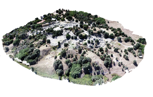
Understanding Archaeological Site Topography: 3D Archaeology of ArchaeologyRewriting Archaeological Narratives: Archaeology of Archaeology through 3D Site Topography RecordingRecommended by Devi Taelman based on reviews by Geert Verhoeven, Jesús García-Sánchez and Catherine Scott
Even though applications of 3D recording have existed in archaeology for a long time, it is only since the early 2000s that this field of research has become mainstream thanks to technological advances, and the availability of low-cost sensors and image-based modelling software. This has led to significant changes in the way archaeological sites are documented. This paper entitled "Understanding Archaeological Site Topography: 3D Archaeology of Archaeology" by Jitte Waagen & Gert Jan van Wijngaarden (2024) presents an overview of the current developments in the application possibilities of 3D site topography recording in archaeology. The paper is the result of the round table discussion "Understanding Archaeological Site Topography: 3D Archaeology of Archaeology" at the CAA conference on 5 April 2023 in Amsterdam, with contributions from Radu Brunchi, Nicola Lercari, Joep Orbons, Davide Tanasi, Alicia Walsh, Pawel Wolf and Teagan Zoldoske. The paper starts with a discussion of the Amsterdam Troy Project (ATP). In the frame of the ATP, the rich history of archaeological activity (over 150 years of fieldwork) at Troy is being studied to explore how previous archaeological research has helped to shape the current topography of the site and how these earlier research activities, embedded in their contemporary theoretical frameworks, have determined our understanding of the site (see Murray and M. Spriggs 2017, Carver 2011 for the influence of theory on archaeological fieldwork and archaeology as a discipline), the so-called 'Archaeology of Archaeology' approach. In addition to studying previous research records and re-excavating old excavation trenches, a central element of the project is the 3D recording of the past and present topography of the site in order to reconstruct the archaeological research activities at the site and their impact on the archaeological landscape. The paper focuses on current trends in 3D recording of archaeological site topography and discusses three main areas where 3D recording of archaeological site topography can contribute to the "Archaeology of Archaeology" approach: (1) monitoring the topography of sites for preservation, conservation, research and dissemination purposes; (2) reconstructing, reevaluating and reinterpreting past archaeological research efforts; and (3) archiving in a 4D (GIS) environment. This is done using the example of the Amsterdam Troy project and comparing it with other projects using similar methods and approaches. Using these case studies, the authors effectively discuss the impact of these technologies on the understanding of the topography of archaeological sites and how 3D recording can enhance archaeological research methodologies and interpretations, for example, by not using such 3D approaches as a stand-alone product but integrating them with available information from previous research activities. They also recognise the limitations and challenges involved, such as the need for customised data acquisition strategies and the lack of ready-made software solutions for developing comprehensive data management strategies. One topic that could have been covered in more detail is how 3D site topography recording (and 3D recording in general) is affected by current theoretical developments in archaeology. Like any other archaeological fieldwork or data collection approach, it is a child of its time. Decisions such as what to record, how to record, what to store, how to store, what to visualise, and how to visualise influence our understanding of archaeological sites (Ward 2022). This minor critical reflection aside, the paper makes a timely and significant contribution to archaeology by addressing current trends and the limitations of the increasingly widespread use of 3D site topography recording technologies. References Carver, G. (2011). Reflections on the archaeology of archaeological excavation, Archaeological Dialogues 18(1), pp. 18–26. https://doi.org/10.1017/S1380203811000067 Murray, T. and Spriggs, M. (2017). The historiography of archaeology: exploring theory, contingency and rationality, World Archaeology 49(2), pp. 151–157. https://doi.org/10.1080/00438243.2017.1334583 Ward, C. (2022). Excavating the Archive / Archiving the Excavation: Archival Processes and Contexts in Archaeology, Advances in Archaeological Practice 10(2), pp. 160–176. https://doi.org/10.1017/aap.2022.1 Waagen, J. and van Wijngaarden, G.J. (2024). Understanding Archaeological Site Topography: 3D Archaeology of Archaeology, Zenodo, 10061343, ver. 3 peer-reviewed and recommonded by Peer Community in Archaeology. https://doi.org/10.5281/zenodo.10061343 | Understanding Archaeological Site Topography: 3D Archaeology of Archaeology | Waagen, Jitte & Wijngaarden, Gert Jan van | <p>The current ubiquitous use of 3D recording technologies in archaeological fieldwork, for a large part due to the application of budget-friendly (drone) sensors and the availability of many low-cost image-based 3D modelling software packages, ha... | | Computational archaeology, Remote sensing | Devi Taelman | 2023-10-17 23:03:47 | ||
25 Jul 2023
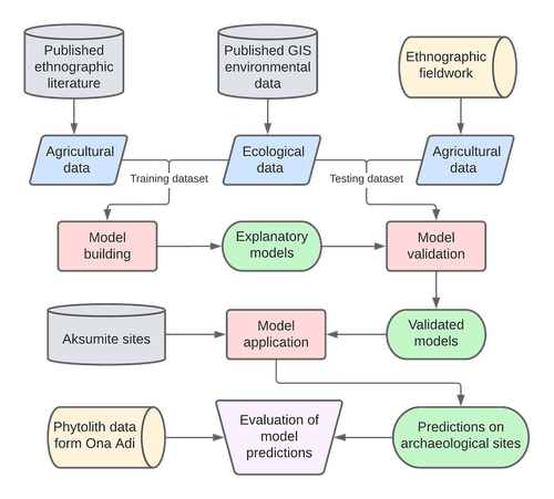
Sorghum and finger millet cultivation during the Aksumite period: insights from ethnoarchaeological modelling and microbotanical analysisAn innovative integration of ethnoarchaeological models with phytolith data to study histories of C4 crop cultivationRecommended by Emma Loftus based on reviews by Tanya Hattingh and 1 anonymous reviewerThis article “Sorghum and finger millet cultivation during the Aksumite period: insights from ethnoarchaeological modelling and microbotanical analysis”, submitted by Ruiz-Giralt and colleagues (2023a), presents an innovative attempt to address the lack of palaeobotanical data concerning ancient agricultural strategies in the northern Horn of Africa. In lieu of well-preserved macrobotanical remains, an especial problem for C4 crop species, these authors leverage microbotanical remains (phytoliths), in combination with ethnoarchaeologically-informed agroecology models to investigate finger millet and sorghum cultivation during the period of the Aksumite Kingdom (c. 50 BCE – 800 CE). Both finger millet and sorghum have played important roles in the subsistence of the Horn region, and throughout much of the rest of Africa and the world in the past. The importance of these drought-resistant and adaptable crops is likely to increase as we move into a warmer, drier world. Yet their histories of cultivation are still only approximately sketched due to a paucity of well-preserved remains from archaeological sites - for example, debate continues as to the precise centre of their domestication. Recent studies of phytoliths (by these and other authors) are demonstrating the likely continuous presence of these crops from the pre-Aksumite period. However, phytoliths are diagnostic only to broad taxonomic levels, and cannot be used to securely identify species. To supplement these observations, Ruiz-Giralt et al. deploy models (previously developed by this team: Ruiz-Giralt et al., 2023b) that incorporate environmental variables and ethnographic data on traditional agrosystems. They evaluate the feasibility of different agricultural regimes around the locations of numerous archaeological sites distributed across the highlands of northern Ethiopia and southern Eritrea. Their results indicate the general viability of finger millet and sorghum cultivation around archaeological settlements in the past, with various regions displaying greater-or-lesser suitability at different distances from the site itself. The models also highlight the likelihood of farmers utilising extensive-rainfed regimes, given low water and soil nutrient requirements for these crops. The authors discuss the results with respect to data on phytolith assemblages, particularly at the site of Ona Adi. They conclude that Aksumite agriculture very likely included the cultivation of finger millet and sorghum, as part of a broader system of rainfed cereal cultivation. Ruiz-Giralt et al. argue, and have demonstrated, that ethnoarchaeologically-informed models can be used to generate hypotheses to be evaluated against archaeological data. The integration of many diverse lines of information in this paper certainly enriches the discussion of agricultural possibilities in the past, and the use of a modelling framework helps to formalise the available hypotheses. However, they emphasise that modelling approaches cannot be pursued in lieu of rigorous archaeobotanical studies but only in tandem - a greater commitment to archaeobotanical sampling is required in the region if we are to fully detail the histories of these important crops. References Ruiz-Giralt, A., Beldados, A., Biagetti, S., D’Agostini, F., D’Andrea, A. C., Meresa, Y. and Lancelotti, C. (2023a). Sorghum and finger millet cultivation during the Aksumite period: insights from ethnoarchaeological modelling and microbotanical analysis. Zenodo, 7859673, ver. 3 peer-reviewed and recommended by Peer Community in Archaeology. https://doi.org/10.5281/zenodo.7859673 Ruiz-Giralt, A., Biagetti, S., Madella, M. and Lancelotti, C. (2023b). Small-scale farming in drylands: New models for resilient practices of millet and sorghum cultivation. PLoS ONE 18, e0268120. https://doi.org/10.1371/journal.pone.0268120
| Sorghum and finger millet cultivation during the Aksumite period: insights from ethnoarchaeological modelling and microbotanical analysis | Abel Ruiz-Giralt, Alemseged Beldados, Stefano Biagetti, Francesca D’Agostini, A. Catherine D’Andrea, Yemane Meresa, Carla Lancelotti | <p>For centuries, finger millet (<em>Eleusine coracana</em> Gaertn.) and sorghum (<em>Sorghum bicolor</em> (L.) Moench) have been two of the most economically important staple crops in the northern Horn of Africa. Nonetheless, their agricultural h... | | Africa, Archaeobotany, Computational archaeology, Protohistory, Spatial analysis | Emma Loftus | 2023-04-29 16:24:54 | ||
19 Feb 2024
Social Network Analysis of Ancient Japanese Obsidian Artifacts Reflecting Sampling Bias ReductionEvaluating Methods for Reducing Sampling Bias in Network AnalysisRecommended by James Allison based on reviews by Matthew Peeples and 1 anonymous reviewer
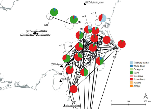
In a recent article, Fumihiro Sakahira and Hiro'omi Tsumura (2023) used social network analysis methods to analyze change in obsidian trade networks in Japan throughout the 13,000-year-long Jomon period. In the paper recommended here (Sakahira and Tsumura 2024), Social Network Analysis of Ancient Japanese Obsidian Artifacts Reflecting Sampling Bias Reduction they revisit that data and describe additional analyses that confirm the robustness of their social network analysis. The data, analysis methods, and substantive conclusions of the two papers overlap; what this new paper adds is a detailed examination of the data and methods, including use of bootstrap analysis to demonstrate the reasonableness of the methods they used to group sites into clusters. Both papers begin with a large dataset of approximately 21,000 artifacts from more than 250 sites dating to various times throughout the Jomon period. The number of sites and artifacts, varying sample sizes from the sites, as well as the length of the Jomon period, make interpretation of the data challenging. To help make the data easier to interpret and reduce problems with small sample sizes from some sites, the authors assign each site to one of five sub-periods, then define spatial clusters of sites within each period using the DBSCAN algorithm. Sites with at least three other sites within 10 km are joined into clusters, while sites that lack enough close neighbors are left as isolates. Clusters or isolated sites with sample sizes smaller than 30 were dropped, and the remaining sites and clusters became the nodes in the networks formed for each period, using cosine similarities of obsidian assemblages to define the strength of ties between clusters and sites. The main substantive result of Sakahira and Tsumura’s analysis is the demonstration that, during the Middle Jomon period (5500-4500 cal BP), clusters and isolated sites were much more connected than before or after that period. This is largely due to extensive distribution of obsidian from the Kozu-shima source, located on a small island off the Japanese mainland. Before the Middle Jomon period, Kozu-shima obsidian was mostly found at sites near the coast, but during the Middle Jomon, a trade network developed that took Kozu-shima obsidian far inland. This ended after the Middle Jomon period, and obsidian networks were less densely connected in the late and last Jomon periods. The methods and conclusions are all previously published (Sakahira and Tsumura 2023). What Sakahira and Tsumura add in Social Network Analysis of Ancient Japanese Obsidian Artifacts Reflecting Sampling Bias Reduction are: · an examination of the distribution of cosine similarities between their clusters for each period · a similar evaluation of the cosine similarities within each cluster (and among the unclustered sites) for each period · bootstrap analyses of the mean cosine similarities and network densities for each time period These additional analyses demonstrate that the methods used to cluster sites are reasonable, and that the use of spatially defined clusters as nodes (rather than the individual sites within the clusters) works well as a way of reducing bias from small, unrepresentative samples. An alternative way to reduce that bias would be to simply drop small assemblages, but that would mean ignoring data that could usefully contribute to the analysis. The cosine similarities between clusters show patterns that make sense given the results of the network analysis. The Middle Jomon period has, on average, the highest cosine similarities between clusters, and most cluster pairs have high cosine similarities, consistent with the densely connected, spatially expansive network from that time period. A few cluster pairs in the Middle Jomon have low similarities, apparently representing comparisons including one of the few nodes on the margins on the network that had little or no obsidian from the Kozu-shima source. The other four time periods all show lower average inter-cluster similarities and many cluster pairs have either high or low similarities. This probably reflects the tendency for nearby clusters to have very similar obsidian assemblages to each other and for geographically distant clusters to have dissimilar obsidian assemblages. The pattern is consistent with the less densely connected networks and regionalization shown in the network graphs. Thinking about this pattern makes me want to see a plot of the geographic distances between the clusters against the cosine similarities. There must be a very strong correlation, but it would be interesting to know whether there are any cluster pairs with similarities that deviate markedly from what would be predicted by their geographic separation. The similarities within clusters are also interesting. For each time period, almost every cluster has a higher average (mean and median) within-cluster similarity than the similarity for unclustered sites, with only two exceptions. This is partial validation of the method used for creating the spatial clusters; sites within the clusters are at least more similar to each other than unclustered sites are, suggesting that grouping them this way was reasonable. Although Sakahira and Tsumura say little about it, most clusters show quite a wide range of similarities between the site pairs they contain; average within-cluster similarities are relatively high, but many pairs of sites in most clusters appear to have low similarities (the individual values are not reported, but the pattern is clear in boxplots for the first four periods). There may be value in further exploring the occurrence of low site-to-site similarities within clusters. How often are they caused by small sample sizes? Clusters are retained in the analysis if they have a total of at least 30 artifacts, but clusters may contain sites with even smaller sample sizes, and small samples likely account for many of the low similarity values between sites in the same cluster. But is distance between sites in a cluster also a factor? If the most distant sites within a spatially extensive cluster are dissimilar, subdividing the cluster would likely improve the results. Further exploration of these within-cluster site-to-site similarity values might be worth doing, perhaps by plotting the similarities against the size of the smallest sample included in the comparison, as well as by plotting the cosine similarity against the distance between sites. Any low similarity values not attributable to small sample sizes or geographic distance would surely be worth investigating further. Sakahira and Tsumura also use a bootstrap analysis to simulate, for each time period, mean cosine similarities between clusters and between site pairs without clustering. They also simulate the network density for each time period before and after clustering. These analyses show that, almost always, mean simulated cosine similarities and mean simulated network density are higher after clustering than before. The simulated mean values also match the actual mean values better after clustering than before. This improved match to actual values when the sites are clustered for the bootstrap reinforces the argument that clustering the sites for the network analysis was a reasonable result. The strength of this paper is that Sakahira and Tsumura return to reevaluate their previously published work, which demonstrated strong patterns through time in the nature and extent of Jomon obsidian trade networks. In the current paper they present further analyses demonstrating that several of their methodological decisions were reasonable and their results are robust. The specific clusters formed with the DBSCAN algorithm may or may not be optimal (which would be unreasonable to expect), but the authors present analyses showing that using spatial clusters does improve their network analysis. Clustering reduces problems with small sample sizes from individual sites and simplifies the network graphs by reducing the number of nodes, which makes the results easier to interpret. Reference Sakahira, F. and Tsumura, H. (2023). Tipping Points of Ancient Japanese Jomon Trade Networks from Social Network Analyses of Obsidian Artifacts. Frontiers in Physics 10:1015870. https://doi.org/10.3389/fphy.2022.1015870 Sakahira, F. and Tsumura, H. (2024). Social Network Analysis of Ancient Japanese Obsidian Artifacts Reflecting Sampling Bias Reduction, Zenodo, 10057602, ver. 7 peer-reviewed and recommended by Peer Community in Archaeology. https://doi.org/10.5281/zenodo.7969330 | Social Network Analysis of Ancient Japanese Obsidian Artifacts Reflecting Sampling Bias Reduction | Fumihiro Sakahira, Hiro’omi Tsumura | <p>This study aims to investigate the dynamics of obsidian trade networks during the Jomon period (approximately 15,000 to 2,400 years ago), the hunting and gathering era in Japan. To improve regional representation and reduce the distortions caus... | | Asia, Computational archaeology | James Allison | Thegn Ladefoged, Matthew Peeples | 2023-05-28 05:51:12 | |
Yesterday
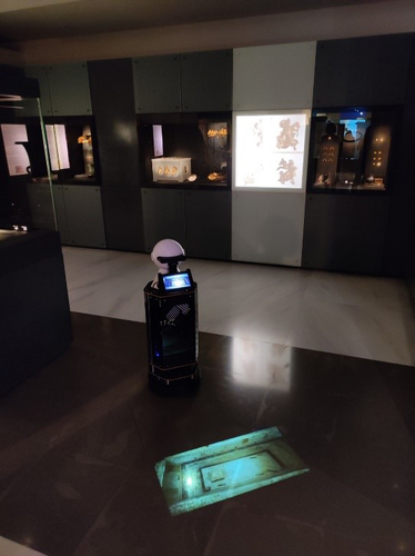
Exploiting RFID Technology and Robotics in the MuseumSocial Robotics in the Museum: a case for human-robot interaction using RFID TechnologyRecommended by Daniel Carvalho based on reviews by Dominik Hagmann, Sebastian Hageneuer and Alexis PantosThe paper “Exploiting RFID Technology and Robotics in the Museum” (Dimitriou et al 2023) is a relevant contribution to museology and an interface between the public, archaeological discourse and the field of social robotics. It deals well with these themes and is concise in its approach, with a strong visual component that helps the reader to understand what is at stake. The option of demonstrating the different steps that lead to the final construction of the robot is appropriate, so that it is understood that it really is a linked process and not simple tasks that have no connection. The use of RFID technology for topological movement of social robots has been continuously developed (e.g., Corrales and Salichs 2009; Turcu and Turcu 2012; Sequeira and Gameiro 2017) and shown to have advantages for these environments. Especially in the context of a museum, with all the necessary precautions to avoid breaching the public's privacy, RFID labels are a viable, low-cost solution, as the authors point out (Dimitriou et al 2023), and, above all, one that does not require the identification of users. It is in itself part of an ambitious project, since the robot performs several functions and not just one, a development compared to other currents within social robotics (see Hellou et al 2022: 1770 for a description of the tasks given to robots in museums). The robotic system itself also makes effective use of the localization system, both physically, by RFID labels and by knowing how to situate itself with the public visiting the museum, adapting to their needs, which is essential for it to be successful (see Gasteiger, Hellou and Ahn 2022: 690 for the theme of localization). Archaeology can provide a threshold of approaches when it comes to social robotics and this project demonstrates that, bringing together elements of interaction, education and mobility in a single method. Hence, this is a paper with great merit and deserves to be recommended as it allows us to think of the museum as a space where humans and non-humans can converge to create intelligible discourses, whether in the historical, archaeological or cultural spheres. References Dimitriou, A. G., Papadopoulou, S., Dermenoudi, M., Moneda, A., Drakaki, V., Malama, A., Filotheou, A., Raptopoulos Chatzistefanou, A., Tzitzis, A., Megalou, S., Siachalou, S., Bletsas, A., Yioultsis, T., Velentza, A. M., Pliasa, S., Fachantidis, N., Tsagkaraki, E., Karolidis, D., Tsoungaris, C., Balafa, P. and Koukouvou, A. (2024). Exploiting RFID Technology and Robotics in the Museum. Zenodo, 7805387, ver. 3 peer-reviewed and recommended by Peer Community in Archaeology. https://doi.org/10.5281/zenodo.7805387 Corrales, A. and Salichs, M.A. (2009). Integration of a RFID System in a Social Robot. In: Kim, JH., et al. Progress in Robotics. FIRA 2009. Communications in Computer and Information Science, vol 44. Springer, Berlin, Heidelberg. https://doi.org/10.1007/978-3-642-03986-7_8 Gasteiger, N., Hellou, M. and Ahn, H.S. (2023). Factors for Personalization and Localization to Optimize Human–Robot Interaction: A Literature Review. Int J of Soc Robotics 15, 689–701. https://doi.org/10.1007/s12369-021-00811-8 Hellou, M., Lim, J., Gasteiger, N., Jang, M. and Ahn, H. (2022). Technical Methods for Social Robots in Museum Settings: An Overview of the Literature. Int J of Soc Robotics 14, 1767–1786 (2022). https://doi.org/10.1007/s12369-022-00904-y Sequeira, J. S., and Gameiro, D. (2017). A Probabilistic Approach to RFID-Based Localization for Human-Robot Interaction in Social Robotics. Electronics, 6(2), 32. MDPI AG. http://dx.doi.org/10.3390/electronics6020032 Turcu, C. and Turcu, C. (2012). The Social Internet of Things and the RFID-based robots. In: IV International Congress on Ultra Modern Telecommunications and Control Systems, St. Petersburg, Russia, 2012, pp. 77-83. https://doi.org/10.1109/ICUMT.2012.6459769 | Exploiting RFID Technology and Robotics in the Museum | Antonis G. Dimitriou, Stella Papadopoulou, Maria Dermenoudi, Angeliki Moneda, Vasiliki Drakaki, Andreana Malama, Alexandros Filotheou, Aristidis Raptopoulos Chatzistefanou, Anastasios Tzitzis, Spyros Megalou, Stavroula Siachalou, Aggelos Bletsas, ... | <p>This paper summarizes the adoption of new technologies in the Archaeological Museum of Thessaloniki, Greece. RFID technology has been adopted. RFID tags have been attached to the artifacts. This allows for several interactions, including tracki... | | Conservation/Museum studies, Remote sensing | Daniel Carvalho | 2023-04-10 14:04:23 | ||
20 Jun 2020
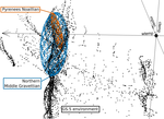
Investigating relationships between technological variability and ecology in the Middle Gravettian (ca. 32-28 ka cal. BP) in France.Understanding Palaeolithic adaptations through niche modelling - the case of the French Middle GravettianRecommended by Felix Riede based on reviews by Andreas Maier and João MarreirosThe paper entitled “Investigating relationships between technological variability and ecology in the Middle Gravettian (ca. 32-28 ky cal. BP) in France” [1] submitted by A. Vignoles and colleagues offers a robust and interesting new analysis of the niche differences between the Rayssian and Noaillian facies of the Middle Gravettian in France. Understanding technological variability in the Palaeolithic is a long-standing challenge. Previous debates have vacillated between strong, quasi-ethnic culture-historical interpretations rooted in the traditional European school and extreme functional stances that would see artefact forms and their frequencies with assemblages conditioned by site function. While both positions have their merits, many empirical and conceptual caveats haunt them equally [see 2]. In this new study Vignoles and colleagues, so-called eco-cultural niche modelling is applied in an attempt to explore whether, and if so, which environmental background factors may have conditioned the emergence and persistence of two sub-cultural categories (facies) within the Middle Gravettian: the Rayssian and the Noaillian. These are are defined through, respectively, a specific knapping method and the presence of a specific burin type, and the occurrence of these seems divided by the Garonne River. Eco-cultural niche modelling has emerged as an archaeological application of distribution models widely employed in ecology, including palaeoecology, to understand organismal niche envelopes [3]. They constitute powerful tools for using the spatial and chronological information inherent in the archaeological record to up-scale interpretations of human-environment relations beyond individual site stratigraphies or dating series. Another important feature of such models is that their performance can, as Vignoles et al. also show, be formally evaluated and replicated. Following on from earlier applications of such techniques [e.g. 4], the authors here present an interesting study that uses very specific archaeological indicators – namely the Raysse method and the Noaillian burin – as defining features for the units (communities, traditions) whose adaptations they investigate. While broad tool types have previously been used as cultural taxonomic indicators in niche modelling studies [5], the present study is ambitious in its attempt to understand variability at a relatively small spatial scale. This mirrors equally interesting attempts of doing so in later prehistoric contexts [6]. Applications of niche modelling that use analytical units defined through archaeological characteristics (technology, typology) are opening up exciting new opportunities for pinning down precisely which environmental or climatic features these cultural components reference, if any. The study by Vignoles et al. makes a good case. At the same time, this approach also acutely raises questions of cultural taxonomy, of how we define our units of analysis and what they might mean [7]. It remains unclear to whether we can define such units on the basis of very different technological traits if the aim is to then use them as taxonomically equivalent in subsequent analyses. There is also a risk that these facies become reified as traditions of sub-cultures – then often further equated with specific people – through an overly normative view of their constituent technological elements. In addition, studies of adaptation in principle need to be conscious of the so-called ‘Galton’s Problem’, where the historical relatedness of the analytical units in question need to be taken into account in seeking salient correlations between cultural and environmental features [8]. In pushing forward eco-cultural niche modelling, the study by Vignoles et al. thus takes us some way forward in understanding the potentially adaptive variability within the Gravettian; future work should consider more strongly the specific historical relatedness amongst the cultural taxa under study and follow more theory-driven definition thereof. Such definition would also allow the post-analysis interpretations of eco-cultural niche modelling to be more explicit. Without doubt, the Gravettian as a whole – including, for instance, phenomena such as the Maisierian [9] – would benefit from additional and extended applications of this method. Similarly, other periods of the Palaeolithic also characterized by such variability (e.g. the Magdalenian and Final Palaeolithic) offer additional cases moving forward. Bibliography [1] Vignoles, A. et al. (2020). Investigating relationships between technological variability and ecology in 1 the Middle Gravettian (ca. 32-28 ky cal. BP) in France. PCI Archaeology. 10.31219/osf.io/ud3hj [2] Dibble, H.L., Holdaway, S.J., Lin, S.C., Braun, D.R., Douglass, M.J., Iovita, R., McPherron, S.P., Olszewski, D.I., Sandgathe, D., 2017. Major Fallacies Surrounding Stone Artifacts and Assemblages. Journal of Archaeological Method and Theory 24, 813–851. 10.1007/s10816-016-9297-8 [3] Svenning, J.-C., Fløjgaard, C., Marske, K.A., Nógues-Bravo, D., Normand, S., 2011. Applications of species distribution modeling to paleobiology. Quaternary Science Reviews 30, 2930–2947. 10.1016/j.quascirev.2011.06.012 [4] Banks, W.E., d’Errico, F., Dibble, H.L., Krishtalka, L., West, D., Olszewski, D.I., Townsend Petersen, A., Anderson, D.G., Gillam, J.C., Montet-White, A., Crucifix, M., Marean, C.W., Sánchez-Goñi, M.F., Wolfarth, B., Vanhaeren, M., 2006. Eco-Cultural Niche Modeling: New Tools for Reconstructing the Geography and Ecology of Past Human Populations. PaleoAnthropology 2006, 68–83. [5] Banks, W.E., Zilhão, J., d’Errico, F., Kageyama, M., Sima, A., Ronchitelli, A., 2009. Investigating links between ecology and bifacial tool types in Western Europe during the Last Glacial Maximum. Journal of Archaeological Science 36, 2853–2867. 10.1016/j.jas.2009.09.014 [6] Whitford, B.R., 2019. Characterizing the cultural evolutionary process from eco-cultural niche models: niche construction during the Neolithic of the Struma River Valley (c. 6200–4900 BC). Archaeological and Anthropological Sciences 11, 2181–2200. 10.1007/s12520-018-0667-x [7] Reynolds, N., Riede, F., 2019. House of cards: cultural taxonomy and the study of the European Upper Palaeolithic. Antiquity 93, 1350–1358. 10.15184/aqy.2019.49 [8] Mace, R., Pagel, M.D., 1994. The Comparative Method in Anthropology. Current Anthropology 35, 549–564. 10.1086/204317 [9] Pesesse, D., 2017. Is it still appropriate to talk about the Gravettian? Data from lithic industries in Western Europe. Quartär 64, 107–128. 10.7485/QU64_5 | Investigating relationships between technological variability and ecology in the Middle Gravettian (ca. 32-28 ka cal. BP) in France. | Anaïs Vignoles, William E. Banks, Laurent Klaric, Masa Kageyama, Marlon E. Cobos, Daniel Romero-Alvarez | <p>The French Middle Gravettian represents an interesting case study for attempting to identify mechanisms behind the typo-technological variability observed in the archaeological record. Associated with the relatively cold and dry environments of... | | Europe, Lithic technology, Paleoenvironment, Peopling, Upper Palaeolithic | Felix Riede | 2020-03-23 12:16:20 | ||
24 Jun 2021
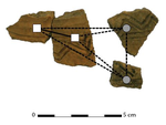
The strength of parthood ties. Modelling spatial units and fragmented objects with the TSAR method – Topological Study of Archaeological RefittingA practical computational approach to stratigraphic analysis using conjoinable material culture.Recommended by Hector A. Orengo based on reviews by Robert Bischoff, Matthew Peeples and 1 anonymous reviewerThe paper by Plutniak [1] presents a new method that uses refitting to help interpret stratigraphy using the topological distribution of conjoinable material culture. This new method opens up new avenues to the archaeological use of network analysis but also to assess the integrity of interpreted excavation layers. Beyond its evident applicability to standard excavation practice, the paper presents a series of characteristics that exemplify archaeological publication best practices and, as someone more versed in computational than in refitting studies I would like to comment upon. It was no easy task to find adequate reviewers for this paper as it combines techniques and expertise that are not commonly found together in individual researchers. However, Plutniak, with help from three reviewers, particularly M. Peeples, a leading figure in archaeological applications of network science, makes a considerable effort to be accessible to non-specialist archaeologists. The core Topological Study of Archaeological Refitting (TSAR) method is freely accessible as the R package archeofrag, which is available at the Comprehensive R Archive Network (https://CRAN.R-project.org/package=archeofrag) that can be applied without the need to understand all its mathematical, graph theory and coding aspects. Beside these, an online interface including test data has been provided (https://analytics.huma-num.fr/Sebastien.Plutniak/archeofrag/), which aims to ease access to the method to those archaeologists inexperienced with R. Finally, supplementary material showing how to use the package and evaluating its potential through excellent examples is provided as both pdf and Rmw (Sweave) files. This is an important companion for the paper as it allows a better understanding of the methods presented in the paper and its practical application. The author shows particular care in testing the potential and capabilities of the method. For example, a function is provided “frag.observer.failure” to test the robustness of the edge count method against the TSAR method, which is able to prove that TSAR can deal well with incomplete information. As a further step in this direction both simulated and real field-acquired data are used to test the method which further proves that archeofrag is not only able to quantitatively assess the mixture of excavated layers but to propose meaningful alternatives, which no doubt will add an increased methodological consistency and thoroughness to previous quantitative approaches to material refitting work, even when dealing with very complex stratigraphies. All in all, this paper makes an important contribution to core archaeological practice through the use of innovative, reproducible and accessible computational methods. I fully endorse it for the conscious and solid methods it presents but also for its adherence to open publication practices. I hope that it can become of standard use in the reconstruction of excavated stratigraphical layers through conjoinable material culture.
[1] Plutniak, S. 2021. The Strength of Parthood Ties. Modelling Spatial Units and Fragmented Objects with the TSAR Method – Topological Study of Archaeological Refitting. OSF Preprints, q2e69, ver. 3 Peer-reviewed and recommended by PCI Archaeology. https://doi.org/10.31219/osf.io/q2e69. | The strength of parthood ties. Modelling spatial units and fragmented objects with the TSAR method – Topological Study of Archaeological Refitting | Sébastien Plutniak | <p>Refitting and conjoinable pieces have long been used in archaeology to assess the consistency of discrete spatial units, such as layers, and to evaluate disturbance and post-depositional processes. The majority of current methods, despite their... | | Computational archaeology, Taphonomy | Hector A. Orengo | 2021-01-14 18:31:01 | ||
01 Dec 2021
A closer look at an eroded dune landscape: first functional insights into the Federmessergruppen site of Lommel-MaatheidePotential of a large-scale functional analysis to reconstructing past human activities at the Final Palaeolithic site of Lommel-MaatheideRecommended by Marta Arzarello and Alice Leplongeon based on reviews by Gabriele Luigi Francesco Berruti and Ana Abrunhosa
The paper “A closer look at an eroded dune landscape: first functional insights into the Federmessergruppen site of Lommel-Maatheide” [1] focuses on the final Palaeolithic (Federmesser) site of Lommel-Maatheide. Federmesser sites from northern Belgium such as Lommel-Maatheide, Meer and Rekem, show evidence for dense human occupation of specific areas located on top of Tardiglacial dunes nearby water bodies [2]. Preserved spatial distribution of finds at the sites suggest different activity areas and the presence of habitat structures [2]. However, because of the low organic preservation at the sites, functional analyses of lithic assemblages have the potential to significantly contribute to the spatial organisation of activities at these sites. This study by Tomasso et al. [1], represents an excellent example of a large-scale integrated approach to the study of lithic industries. The article undoubtedly demonstrates the potential of the proposed methodology and the reliability of the results obtained. The article explores two different aspects (linked and excellently interconnected here): the possibility to apply use wear, residue and fracture analyses, on lithic assemblages affected by taphonomical alterations and to study lithic assemblages from dune landscapes. The study allows to answer differentiated questions: what is the influence of taphonomical alterations on use wear analysis? How do excavation methods impact the formation of use wear and the preservation of residues? Can we recognize distinct domestic activities? The article also provides an interesting hypothesis about hunting activities and propulsion methods. The applied methodology is effectively interdisciplinary and innovative. It demonstrates how a truly integrated and articulated approach can represent the turning point for going beyond a mainly descriptive dimension to move towards a real understanding of the sites. Studies dedicated to the analysis of the propulsion mode are not very frequent, but they are surely very important to better understand human behaviour [3]. Here, the methodology developed for the evaluation of the propulsion mode represent an important starting point for the definition of a new approach. Morphological and morphometrical analysis are integrated to the evaluation of the mechanical stress, to fracture delineations and to the hafting system (the latter defined on experimental basis). This article therefore underlines the potential of combining different approaches to functional analysis associated with a ‘tailored’ reference collection and applying them to a high number of artefacts for reconstructing past human activities involving materials that are otherwise not preserved in these contexts. [1] Tomasso, S., Cnuts, D., Coppe, J., Geerts, F., Gils, M.V., Bie, M.D., Rots, V. (2021). A closer look at an eroded dune landscape: first functional insights into the Federmessergruppen site of Lommel-Maatheide. https://doi.org/10.31219/osf.io/pf3sm, ver 3 peer-reviewed and recommended by PCI Archaeology. [2] De Bie, M., Van Gils, M. (2006). Les habitats des groupes à Federmesser (aziliens) dans le Nord de la Belgique. Bulletin de la Société préhistorique française, 103, 781–790. [3] Coppe, J., Lepers, C., Clarenne, V., Delaunois, E., Pirlot, M. and Rots V. (2019). Ballistic Study Tackles Kinetic Energy Values of Palaeolithic Weaponry. Archaeometry, (61)4, 933-956. https://doi.org/10.1111/arcm.12452 | A closer look at an eroded dune landscape: first functional insights into the Federmessergruppen site of Lommel-Maatheide | Sonja Tomasso, Dries Cnuts, Justin Coppe, Marijn Van Gils, Ferdi Geerts, Marc De Bie, Veerle Rots | <p>The vast Federmessergruppen site of Lommel-Maatheide, which is located in the Campine region (Northern Belgium), revealed the presence of numerous Final Palaeolithic concentrations situated on a large Late Glacial sand ridge on the northern edg... | | Environmental archaeology, Landscape archaeology, Lithic technology, Traceology, Upper Palaeolithic | Marta Arzarello | 2021-09-14 17:04:38 |


