Latest recommendations

| Id | Title * | Authors * ▲ | Abstract * | Picture * | Thematic fields * | Recommender | Reviewers | Submission date | |
|---|---|---|---|---|---|---|---|---|---|
22 Apr 2024
The transformation of an archaeological community and its resulting representations in the context of the co-development of open Archaeological Information SystemsExploring The Role of Archaeological Information Systems in Improving Data Management and InteroperabilityRecommended by James Stuart Taylor based on reviews by 2 anonymous reviewers based on reviews by 2 anonymous reviewers
In response to the feedback provided by the reviewers, the authors have undertaken a comprehensive revision of the manuscript [1]. These revisions have specifically targeted the primary concerns raised regarding the clarity and structure of the argument concerning the transformative impact of Archaeological Information Systems (AIS) on archaeological practices. In my view the revised manuscript now more clearly articulates the distinction between internal and external interoperability and emphasizes the critical importance of integrating contextual information with archaeological data. This approach directly addresses the previously identified need for enhanced traceability and usability of archaeological data, ensuring that the manuscript's contributions to the field are both clear and impactful. Moreover, the application of the proposed model at the Bibracte site is illustrated with greater clarity, serving as a concrete example of how the challenges associated with documentation and data management can be effectively addressed through the methodologies proposed in the paper. This practical demonstration enriches the manuscript, providing readers with a much clearer understanding of the model's applicability and benefits in real-world archaeological practice. The authors have also made significant efforts to refine the overall structure and coherence of the manuscript. By making complex concepts more accessible and ensuring a cohesive narrative flow throughout, the manuscript now offers a more engaging and comprehensible read. This has been achieved through careful rephrasing and restructuring of sections, particularly those relating to the T!O model's application and the conclusion, thereby enhancing reader engagement and comprehension. Alongside these structural and conceptual clarifications, explicit discussion of potential areas for future research, not only acknowledges the limitations of the current study but also highlights the significant potential for digital technologies to contribute to archaeological methodology and knowledge production. As such, the manuscript opens up new avenues for exploration and invites further scholarly engagement with the topics it addresses. I believe, these revisions address the earlier feedback quite comprehensively, presenting a robust and compelling argument for the adoption of collaborative and technologically informed approaches in the field of archaeology. The manuscript now stands as a strong example of the critical role AIS could/should play in transforming archaeological practices, offering valuable insights into how these kinds of systems might enhance the management, accessibility, and understanding of archaeological data. Through this revised submission, the authors have significantly strengthened their contribution to the ongoing discourse on digital archaeology, demonstrating the practical and theoretical implications of their work for the broader archaeological community. I am happy, therefore to recommend this paper for acceptence. Reference [1] Lacombe, E., Lukas, D. and Durost, S. (2024). The transformation of an archaeological community and its resulting representations in the context of the co-development of open Archaeological Information Systems. Zenodo, 8309732, ver. 3 peer-reviewed and recommended by Peer Community in Archaeology. https://doi.org/10.5281/zenodo.8309732
| The transformation of an archaeological community and its resulting representations in the context of the co-development of open Archaeological Information Systems | Eric Lacombe, Dominik Lukas, Sébastien Durost | <p>The adoption of Archaeological Information Systems (AIS) evolves according to multiple factors, both human and technical, as well as endogenous and exogenous. In consequence the ever increasing scope of digital tools, which allow for the organi... | | Computational archaeology, Europe, Protohistory, Theoretical archaeology | James Stuart Taylor | 2023-09-01 18:58:26 | ||
11 Dec 2023
A meta-analysis of Final Palaeolithic/earliest Mesolithic cultural taxonomy and evolution in EuropeQuestioning Final Palaeolithic and early Mesolithic cultural taxonomy with a data-driven statistical approachRecommended by Anaïs Vignoles based on reviews by Dirk Leder and 2 anonymous reviewersCultural taxonomies are an essential tool for archaeologists working with prehistoric material cultures as they have historically been used to create the basic analytical units for studying cultural evolution through time (de Mortillet, 1883 ; Breuil, 1913). This approach has its limits as the taxonomic units are essentially etic constructions, i.e., they are defined in a cultural context exterior to the one that produced the material culture on which they are based (e.g., Pesesse, 2019). But to approach questions related to cultural evolution, one has to define archaeological units with clear geographic and chronological delineations in order to be compared synchronically and diachronically (e.g., Willey and Philips, 1958). In « A meta-analysis of Final Palaeolitic/Earliest Mesolithic cultural taxonomy and evolution in Europe », F. Riede and colleagues propose a novel and interesting approach to question the end of the Palaeolithic and beginning of the Mesolithic’s « named archaeological cultures » (NACs) analytical pertinence (Riede et al., 2023). In this particular context, NACs are indeed very numerous (n = 86) and result from complex and regional research histories. It seems thus pertinent to question the extent to which the said NACs chronological and geographic patterns result from past cultural diversity and evolution, and are not artefacts of research. To do so, the authors adopted a data-driven approach that they describe in detail in the paper. First, they gathered an European data base of lithic tool-kit composition, blade and bladelet technology and armature morphology at 350 key sites considered representative of NACs, dated between 15 and 11 ka (Hussain et al., 2023). These data were then analyzed using geometric morphometrics and a set of statisticaal tests in order to 1) test the coherence of these taxonomic units, and 2) test the chronological change in artefact shape variation. The authors conclude that the data set is partially biased by reasearch practices and histories, as their data-driven approach has only partially replicated traditional NACs for the european Late Palaeolithic/Early Mesolithic. However, their analysis of armature shape evolution has shown a tendency to diversification overtime, a pattern that was already observed in more « traditional » approaches. This study is, in my opinion, an excellent contribution for a significant step in macro-regional approaches to the archaeological record: defining discrete archaeological units that serve as a basis for subsequent analyses aimed at delineating cultural evolutionary processes. The authors propose a carefully designed and statistically grounded procedure in order to achieve these definitions in the most replicable and explicit possible manner. Taking advantage of drawings as a primary source of information is also very original despite several limitations of this approach (such as the necessary selection of most typical artefacts to be represented, the incompleteness of data publication or the difficulty to access all published work across such a large geographic area). The results of the study are convincing enough to allow the authors to discuss the pertinence of European Late Paleo/Early Mesolithic NACs, the potential epistemological and historical factors that could affect this taxonomic framework, as well as to give more weight to the traditional hypothesis of lithic cultural diversification towards the end of the Pleistocene/beginning of the Holocene in Europe. I would also like to underline the authors’ important efforts to ensure transparence and replicability of their study, as well as the accessibility of the data, thanks to extensive supplementary data and a data paper describing their data set in detail. Anaïs L. Vignoles References Breuil, H. (1913). Les subdivisions du paléolithique supérieur et leur signification. In Congrès international d’anthropologie et d’archéologie préhistoriques - compte-rendu de la XIVème session, tome 1:165‑238. Genève: Imprimerie Albert Kündig. Hussain, S. T., Riede, F., Matzig, D. N., Biard, M., Crombé, P., Fernández-Lopéz de Pablo, J., Fontana, F., Groß, D., Hess, T., Langlais, M., Mevel, L., Mills, W., Moník, M., Naudinot, N., Posch, C., Rimkus, T., Stefański, D. and Vandendriessche, H. (2023). A Pan-European Dataset Revealing Variability in Lithic Technology, Toolkits, and Artefact Shapes ~15-11 Kya. Scientific Data 10 (1): 593. https://doi.org/10.1038/s41597-023-02500-9. Mortillet, G. (1883). Le Préhistorique, antiquité de l’homme. Reinwald. Paris. Pesesse, D. (2019). Analyser un silex, le façonner à nouveau ? Sur certains usages de la chaîne opératoire au Paléolithique supérieur. Techniques & culture, no 71: 74‑77. https://doi.org/10.4000/tc.11321. Riede, F., Matzig, D. N., Biard, M., Crombé, P., Fernández-Lopéz de Pablo, J., Fontana, F., Groß, D., Hess, T., Langlais, M., Mevel, L., Mills, W., Moník, M., Naudinot, N., Posch, C., Rimkus, T., Stefański, D., Vandendriessche, H. and Hussain, S. T. (2023). A meta-analysis of Final Palaeolithic/earliest Mesolithic cultural taxonomy and evolution in Europe, Zenodo, 8195587., ver. 3 peer-reviewed and recommended by Peer Community in Archaeology. https://doi.org/10.5281/zenodo.8195587 Willey, G. R. and Phillips, P. (1958). Method and Theory in American Archaeology. Chicago, IL: The University of Chicago Press. | A meta-analysis of Final Palaeolithic/earliest Mesolithic cultural taxonomy and evolution in Europe | Felix Riede, David N. Matzig, Miguel Biard, Philippe Crombé, Javier Fernández-Lopéz de Pablo, Federica Fontana, Daniel Groß, Thomas Hess, Mathieu Langlais, Ludovic Mevel, William Mills, Martin Moník, Nicolas Naudinot, Caroline Posch, Tomas Rimkus,... | <p>Archaeological systematics, together with spatial and chronological information, are commonly used to infer cultural evolutionary dynamics in the past. For the study of the Palaeolithic, and particularly the European Final Palaeolithic and earl... | | Computational archaeology, Europe, Lithic technology, Mesolithic, Upper Palaeolithic | Anaïs Vignoles | 2023-07-29 16:06:17 | ||
10 Jan 2024
Linking Scars: Topology-based Scar Detection and Graph Modeling of Paleolithic Artifacts in 3DA valuable contribution to automated analysis of palaeolithic artefactsRecommended by Sebastian Hageneuer based on reviews by Lutz Schubert and 1 anonymous reviewer
In this paper (Linsel/Bullenkamp/Mara 2024), the authors propose an automatic system for scar-ridge-pattern detection on palaeolithic artefacts based on Morse Theory. Scare-Ridge pattern recognition is a process that is usually done manually while creating a drawing of the object itself. Automatic systems to detect scars or ridges exist, but only a small amount of them is utilizing 3D data. In addition to the scar-ridges detection, the authors also experiment in automatically detecting the operational sequence, the temporal relation between scars and ridges. As a result, they can export a traditional drawing as well as graph models displaying the relationships between the scars and ridges. After an introduction to the project and the practice of documenting palaeolithic artefacts, the authors explain their procedure in automatising the analysis of scars and ridges as well as their temporal relation to each other on these artefacts. To illustrate the process, an open dataset of lithic artefacts from the Grotta di Fumane, Italy, was used and 62 artefacts selected. To establish a Ground Truth, the artefacts were first annotated manually. The authors then continue to explain in detail each step of the automated process that follows and the results obtained. In the second part of the paper, the results are presented. First the results of the segmentation process shows that the average percentage of correctly labelled vertices is over 91%, which is a remarkable result. The graph modelling however shows some more difficulties, which the authors are aware of. To enhance the process, the authors rightfully aim to include datasets of experimental archaeology in the future. They also aim to develop a way of detecting the operational sequence automatically and precisely. This paper has great potential as it showcases exactly what Digital and Computational Archaeology is about: The development of new digital methods to enhance the analysis of archaeological data. While this procedure is still in development, the authors were able to present a valuable contribution to the automatization of analytical archaeology. By creating a step towards the machine-readability of this data, they also open up the way to further steps in machine learning within Archaeology. BibliographyLinsel, F., Bullenkamp, J. P., and Mara, H. (2024). Linking Scars: Topology-based Scar Detection and Graph Modeling of Paleolithic Artifacts in 3D, Zenodo, 8296269, ver. 3 peer-reviewed and recommended by Peer Community in Archaeology. https://doi.org/10.5281/zenodo.8296269 | Linking Scars: Topology-based Scar Detection and Graph Modeling of Paleolithic Artifacts in 3D | Florian Linsel, Jan Philipp Bullenkamp & Hubert Mara | <p>Motivated by the concept of combining the archaeological practice of creating lithic artifact drawings with the potential of 3D mesh data, our goal in this project is not only to analyze the shape at the artifact level, but also to enable a mor... | | Computational archaeology, Europe, Lithic technology, Upper Palaeolithic | Sebastian Hageneuer | 2023-09-01 23:03:59 | ||
19 Feb 2024
Social Network Analysis of Ancient Japanese Obsidian Artifacts Reflecting Sampling Bias ReductionEvaluating Methods for Reducing Sampling Bias in Network AnalysisRecommended by James Allison based on reviews by Matthew Peeples and 1 anonymous reviewer
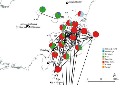
In a recent article, Fumihiro Sakahira and Hiro'omi Tsumura (2023) used social network analysis methods to analyze change in obsidian trade networks in Japan throughout the 13,000-year-long Jomon period. In the paper recommended here (Sakahira and Tsumura 2024), Social Network Analysis of Ancient Japanese Obsidian Artifacts Reflecting Sampling Bias Reduction they revisit that data and describe additional analyses that confirm the robustness of their social network analysis. The data, analysis methods, and substantive conclusions of the two papers overlap; what this new paper adds is a detailed examination of the data and methods, including use of bootstrap analysis to demonstrate the reasonableness of the methods they used to group sites into clusters. Both papers begin with a large dataset of approximately 21,000 artifacts from more than 250 sites dating to various times throughout the Jomon period. The number of sites and artifacts, varying sample sizes from the sites, as well as the length of the Jomon period, make interpretation of the data challenging. To help make the data easier to interpret and reduce problems with small sample sizes from some sites, the authors assign each site to one of five sub-periods, then define spatial clusters of sites within each period using the DBSCAN algorithm. Sites with at least three other sites within 10 km are joined into clusters, while sites that lack enough close neighbors are left as isolates. Clusters or isolated sites with sample sizes smaller than 30 were dropped, and the remaining sites and clusters became the nodes in the networks formed for each period, using cosine similarities of obsidian assemblages to define the strength of ties between clusters and sites. The main substantive result of Sakahira and Tsumura’s analysis is the demonstration that, during the Middle Jomon period (5500-4500 cal BP), clusters and isolated sites were much more connected than before or after that period. This is largely due to extensive distribution of obsidian from the Kozu-shima source, located on a small island off the Japanese mainland. Before the Middle Jomon period, Kozu-shima obsidian was mostly found at sites near the coast, but during the Middle Jomon, a trade network developed that took Kozu-shima obsidian far inland. This ended after the Middle Jomon period, and obsidian networks were less densely connected in the late and last Jomon periods. The methods and conclusions are all previously published (Sakahira and Tsumura 2023). What Sakahira and Tsumura add in Social Network Analysis of Ancient Japanese Obsidian Artifacts Reflecting Sampling Bias Reduction are: · an examination of the distribution of cosine similarities between their clusters for each period · a similar evaluation of the cosine similarities within each cluster (and among the unclustered sites) for each period · bootstrap analyses of the mean cosine similarities and network densities for each time period These additional analyses demonstrate that the methods used to cluster sites are reasonable, and that the use of spatially defined clusters as nodes (rather than the individual sites within the clusters) works well as a way of reducing bias from small, unrepresentative samples. An alternative way to reduce that bias would be to simply drop small assemblages, but that would mean ignoring data that could usefully contribute to the analysis. The cosine similarities between clusters show patterns that make sense given the results of the network analysis. The Middle Jomon period has, on average, the highest cosine similarities between clusters, and most cluster pairs have high cosine similarities, consistent with the densely connected, spatially expansive network from that time period. A few cluster pairs in the Middle Jomon have low similarities, apparently representing comparisons including one of the few nodes on the margins on the network that had little or no obsidian from the Kozu-shima source. The other four time periods all show lower average inter-cluster similarities and many cluster pairs have either high or low similarities. This probably reflects the tendency for nearby clusters to have very similar obsidian assemblages to each other and for geographically distant clusters to have dissimilar obsidian assemblages. The pattern is consistent with the less densely connected networks and regionalization shown in the network graphs. Thinking about this pattern makes me want to see a plot of the geographic distances between the clusters against the cosine similarities. There must be a very strong correlation, but it would be interesting to know whether there are any cluster pairs with similarities that deviate markedly from what would be predicted by their geographic separation. The similarities within clusters are also interesting. For each time period, almost every cluster has a higher average (mean and median) within-cluster similarity than the similarity for unclustered sites, with only two exceptions. This is partial validation of the method used for creating the spatial clusters; sites within the clusters are at least more similar to each other than unclustered sites are, suggesting that grouping them this way was reasonable. Although Sakahira and Tsumura say little about it, most clusters show quite a wide range of similarities between the site pairs they contain; average within-cluster similarities are relatively high, but many pairs of sites in most clusters appear to have low similarities (the individual values are not reported, but the pattern is clear in boxplots for the first four periods). There may be value in further exploring the occurrence of low site-to-site similarities within clusters. How often are they caused by small sample sizes? Clusters are retained in the analysis if they have a total of at least 30 artifacts, but clusters may contain sites with even smaller sample sizes, and small samples likely account for many of the low similarity values between sites in the same cluster. But is distance between sites in a cluster also a factor? If the most distant sites within a spatially extensive cluster are dissimilar, subdividing the cluster would likely improve the results. Further exploration of these within-cluster site-to-site similarity values might be worth doing, perhaps by plotting the similarities against the size of the smallest sample included in the comparison, as well as by plotting the cosine similarity against the distance between sites. Any low similarity values not attributable to small sample sizes or geographic distance would surely be worth investigating further. Sakahira and Tsumura also use a bootstrap analysis to simulate, for each time period, mean cosine similarities between clusters and between site pairs without clustering. They also simulate the network density for each time period before and after clustering. These analyses show that, almost always, mean simulated cosine similarities and mean simulated network density are higher after clustering than before. The simulated mean values also match the actual mean values better after clustering than before. This improved match to actual values when the sites are clustered for the bootstrap reinforces the argument that clustering the sites for the network analysis was a reasonable result. The strength of this paper is that Sakahira and Tsumura return to reevaluate their previously published work, which demonstrated strong patterns through time in the nature and extent of Jomon obsidian trade networks. In the current paper they present further analyses demonstrating that several of their methodological decisions were reasonable and their results are robust. The specific clusters formed with the DBSCAN algorithm may or may not be optimal (which would be unreasonable to expect), but the authors present analyses showing that using spatial clusters does improve their network analysis. Clustering reduces problems with small sample sizes from individual sites and simplifies the network graphs by reducing the number of nodes, which makes the results easier to interpret. Reference Sakahira, F. and Tsumura, H. (2023). Tipping Points of Ancient Japanese Jomon Trade Networks from Social Network Analyses of Obsidian Artifacts. Frontiers in Physics 10:1015870. https://doi.org/10.3389/fphy.2022.1015870 Sakahira, F. and Tsumura, H. (2024). Social Network Analysis of Ancient Japanese Obsidian Artifacts Reflecting Sampling Bias Reduction, Zenodo, 10057602, ver. 7 peer-reviewed and recommended by Peer Community in Archaeology. https://doi.org/10.5281/zenodo.7969330 | Social Network Analysis of Ancient Japanese Obsidian Artifacts Reflecting Sampling Bias Reduction | Fumihiro Sakahira, Hiro’omi Tsumura | <p>This study aims to investigate the dynamics of obsidian trade networks during the Jomon period (approximately 15,000 to 2,400 years ago), the hunting and gathering era in Japan. To improve regional representation and reduce the distortions caus... | | Asia, Computational archaeology | James Allison | Thegn Ladefoged, Matthew Peeples | 2023-05-28 05:51:12 | |
21 Mar 2023
Archaeology, Typology and Machine EpistemologyAutomation and Novelty –Archaeocomputational Typo-Praxis in the Wake of the Third Science RevolutionRecommended by Shumon Tobias Hussain, Felix Riede and Sébastien Plutniak based on reviews by Rachel Crellin and 1 anonymous reviewer
“Archaeology, Typology and Machine Epistemology” submitted by G. Lucas (1) offers a refreshing and welcome reflection on the role of computer-based practice, type-thinking and approaches to typology in the age of big data and the widely proclaimed ‘Third Science Revolution’ (2–4). At the annual meeting of the EAA in Maastricht in 2017, a special thematic block was dedicated to issues and opportunities linked to the Third Science Revolution in archaeology “because of [its] profound and wide ranging impact on practice and theory in archaeology for the years to come” (5). Even though the Third Science Revolution, as influentially outlined by Kristiansen in 2014 (2), has occasionally also been met with skepticism and critique as to its often implicit scientism and epistemological naivety (6–8), archaeology as a whole seems largely euphoric as to the promises of the advancing ‘revolution’. As Lucas perceptively points out, some even regard it as the long-awaited opportunity to finally fulfil the ambitions and goals of Anglophone processualism. The irony here, as Lucas rightly notes, is that early processualists initially foregrounded issues of theory and scientific epistemology, while much work conducted under the banner of the Third Science Revolution, especially within its computational branches, does not. Big data advocates have echoed Anderson’s much-cited “end of theory” (9) or at least emphatically called for an ‘empirization’ and ‘computationalization’ of theory, often under the banner of ‘data-driven archaeology’ (10), yet typically without much specification of what this is supposed to mean for archaeological theory and reflexivity. The latter is indeed often openly opposed by archaeological Third Science Revolution enthusiasts, arguably because it is viewed as part of the supposedly misguided ‘post-modernist’ project. Lucas makes an original meta-archaeological contribution here and attempts to center the epistemological, ontological and praxeological dimensions of what is actually – in situated archaeological praxis and knowledge-production – put at stake by the mobilization of computers, algorithms and artificial intelligence (AI), including its many but presently under-reflected implications for ordering practices such as typologization. Importantly, his perspective thereby explicitly and deliberately breaks with the ‘normative project’ in traditional philosophy of science, which sought to nail down a universal, prescriptive way of doing science and securing scientific knowledge. He instead focuses on the practical dimensions and consequences of computer-reliant archaeologies, what actually happens on the ground as researchers try to grapple with the digital and the artefactual and try to negotiate new insights and knowledge, including all of the involved messiness – thereby taking up the powerful impetus of the broader practice turn in interdisciplinary science studies and STS (Science and Technology Studies (11)) (12–14), which have recently also re-oriented archaeological self-observation, metatheory and epistemology (15). This perspective on the dawning big data age in archaeology and incurred changes in the status, nature and aims of type-thinking produces a number of important insights, which Lucas fruitfully discusses in relation to promises of ‘automation’ and ‘novelty’ as these feature centrally in the rhetorics and politics of the Third Science Revolution. With regard to automation, Lucas makes the important point that machine or computer work as championed by big data proponents cannot adequately be qualified or understood if we approach the issue from a purely time-saving perspective. The question we have to ask instead is what work do machines actually do and how do they change the dynamics of archaeological knowledge production in the process? In this optic, automation and acceleration achieved through computation appear to make most sense in the realm of the uncontroversial, in terms of “reproducing an accepted way of doing things” as Lucas says, and this is precisely what can be observed in archaeological practice as well. The ramifications of this at first sight innocent realization are far-reaching, however. If we accept the noncontroversial claim that automation partially bypasses the need for specialists through the reproduction of already “pre-determined outputs”, automated typologization would primarily be useful in dealing with and synthesizing larger amounts of information by sorting artefacts into already accepted types rather than create novel types or typologies. If we identity the big data promise at least in part with automation, even the detection of novel patterns in any archaeological dataset used to construct new types cannot escape the fact that this novelty is always already prefigured in the data structure devised. The success of ‘supervised learning’ in AI-based approaches illustrates this. Automation thus simply shifts the epistemological burden back to data selection and preparation but this is rarely realized, precisely because of the tacit requirement of broad non-contentiousness. Minimally, therefore, big data approaches ironically curtail their potential for novelty by adhering to conventional data treatment and input formats, rarely problematizing the issue of data construction and the contested status of (observational) data themselves. By contrast, they seek to shield themselves against such attempts and tend to retain a tacit universalism as to the nature of archaeological data. Only in this way is it possible to claim that such data have the capacity to “speak for themselves”. To use a concept borrowed from complexity theory, archaeological automation-based type-construction that relies on supposedly basal, incontrovertible data inputs can only ever hope to achieve ‘weak emergence’ (16) – ‘strong emergence’ and therefore true, radical novelty require substantial re-thinking of archaeological data and how to construct them. This is not merely a technical question as sometimes argued by computational archaeologies – for example with reference to specifically developed, automated object tracing procedures – as even such procedures cannot escape the fundamental question of typology: which kind of observations to draw on in order to explore what aspects of artefactual variability (and why). The focus on readily measurable features – classically dimensions of artefactual form – principally evades the key problem of typology and ironically also reduces the complexity of artefactual realities these approaches assert to take seriously. The rise of computational approaches to typology therefore reintroduces the problem of universalism and, as it currently stands, reduces the complexity of observational data potentially relevant for type-construction in order to enable to exploration of the complexity of pattern. It has often been noted that this larger configuration promotes ‘data fetishism’ and because of this alienates practitioners from the archaeological record itself – to speak with Marxist theory that Lucas briefly touches upon. We will briefly return to the notion of ‘distance’ below because it can be described as a symptomatic research-logical trope (and even a goal) in this context of inquiry. In total, then, the aspiration for novelty is ultimately difficult to uphold if computational archaeologies refuse to engage in fundamental epistemological and reflexive self-engagement. As Lucas poignantly observes, the most promising locus for novelty is currently probably not to be found in the capacity of the machines or algorithms themselves, but in the modes of collaboration that become possible with archaeological practitioners and specialists (and possibly diverse other groups of knowledge stakeholders). In other words, computers, supercomputers and AI technologies do not revolutionize our knowledge because of their superior computational and pattern-detection capacities – or because of some mysterious ‘superintelligence’ – but because of the specific ‘division of labour’ they afford and the cognitive challenge(s) they pose. Working with computers and AI also often requires to ask new questions or at least to adapt the questions we ask. This can already be seen on the ground, when we pay attention to how machine epistemologies are effectively harnessed in archaeological practice (and is somewhat ironic given that the promise of computational archaeology is often identified with its potential to finally resolve "long-standing (old) questions"). The Third Science Revolution likely prompts a consequential transformation in the structural and material conditions of the kinds of ‘distributed’ processes of knowledge production that STS have documented as characteristic for scientific discoveries and knowledge negotiations more generally (14, 17, 18). This ongoing transformation is thus expected not only to promote new specializations with regard to the utilization of the respective computing infrastructures emerging within big data ecologies but equally to provoke increasing demand for new ways of conceptualizing observations and to reformulate the theoretical needs and goals of typology in archaeology. The rediscovery of reflexivity as an epistemic virtue within big data debates would be an important step into this direction, as it would support the shared goal of achieving true epistemic novelty, which, as Lucas points out, is usually not more than an elusive self-declaration. Big data infrastructures require novel modes of human-machine synergy, which simply cannot be developed or cultivated in an atheoretical and/or epistemological disinterested space. Lucas’ exploration ultimately prompts us to ask big questions (again), and this is why this is an important contribution. The elephant in the room, of course, is the overly strong notion of objectivity on which much computational archaeology is arguably premised – linked to the vow to eventually construct ‘objective typologies’. This proclivity, however, re-tables all the problematic debates of the 1960s and – to speak with the powerful root metaphor of the machine fueling much of causal-mechanistic science (19, 20) – is bound to what A. Wylie (21) and others have called the ‘view from nowhere’. Objectivity, in this latter view, is defined by the absence of positionality and subjectivity – chiefly human subjectivity – and the promise of the machine, and by extension of computational archaeology, is to purify and thus to enhance processes of knowledge production by minimizing human interference as much as possible. The distancing of the human from actual processes of data processing and inference is viewed as positive and sometimes even as an explicit goal of scientific development. Interestingly, alienation from the archaeological record is framed as an epistemic virtue here, not as a burden, because close connection with (or even worse, immersion in) the intricacies of artefacts and archaeological contexts supposedly aggravates the problem of bias. The machine, in this optic, is framed as the gatekeeper to an observer-independent reality – which to the backdoor often not only re-introduces Platonian/Aristotelian pledges to a quasi-eternal fabric of reality that only needs to be “discovered” by applying the right (broadly nonhuman) means, it is also largely inconsistent with defendable and currently debated conceptions of scientific objectivity that do not fall prey to dogma. Furthermore, current discussions on the open AI ChatGPT have exposed the enormous and still under-reflected dangers of leaning into radical renderings of machine epistemology: precisely because of the principles of automation and the irreducible theory-ladenness of all data, ecologies such as ChatGPT tend to reinforce the tacit epistemological background structures on which they operate and in this way can become collaborators in the legitimization and justification of the status quo (which again counteracts the potential for novelty) – they reproduce supposedly established patterns of thought. This is why, among other things, machines and AI can quickly become perpetuators of parochial and neocolonial projects – their supposed authority creates a sense of impartiality that shields against any possible critique. With Lucas, we can thus perhaps cautiously say that what is required in computational archaeology is to defuse the authority of the machine in favour of a new community archaeology that includes machines as (fallible) co-workers. Radically put, computers and AI should be recognized as subjects themselves, and treated as such, with interesting perspectives on team science and collaborative practice.
Bibliography 1. Lucas, G. (2022). Archaeology, Typology and Machine Epistemology. https:/doi.org/10.5281/zenodo.7620824. 2. Kristiansen, K. (2014). Towards a New Paradigm? The Third Science Revolution and its Possible Consequences in Archaeology. Current Swedish Archaeology 22, 11–34. https://doi.org/10.37718/CSA.2014.01. 3. Kristiansen, K. (2022). Archaeology and the Genetic Revolution in European Prehistory. Elements in the Archaeology of Europe. https://doi.org/10.1017/9781009228701 4. Eisenhower, M. S. (1964). The Third Scientific Revolution. Science News 85, 322/332. https://www.sciencenews.org/archive/third-scientific-revolution. 5. The ‘Third Science Revolution’ in Archaeology. http://www.eaa2017maastricht.nl/theme4 (March 16, 2023). 6. Ribeiro, A. (2019). Science, Data, and Case-Studies under the Third Science Revolution: Some Theoretical Considerations. Current Swedish Archaeology 27, 115–132. https://doi.org/10.37718/CSA.2019.06 7. Samida, S. (2019). “Archaeology in times of scientific omnipresence” in Archaeology, History and Biosciences: Interdisciplinary Perspectives, pp. 9–22. https://doi.org/10.1515/9783110616651 8. Sørensen, T. F.. (2017). The Two Cultures and a World Apart: Archaeology and Science at a New Crossroads. Norwegian Archaeological Review 50, 101–115. https://doi.org/10.1080/00293652.2017.1367031 9. Anderson, C. (2008). The end of theory: The data deluge makes the scientific method obsolete. Wired. https://www.wired.com/2008/06/pb-theory/. 10. Gattiglia, G. (2015). Think big about data: Archaeology and the Big Data challenge. Archäologische Informationen 38, 113–124. https://doi.org/10.11588/ai.2015.1.26155 11. Hackett, E. J. (2008). The handbook of science and technology studies, Third edition, MIT Press/Society for the Social Studies of Science. 12. Ankeny, R., Chang, H., Boumans, M. and Boon, M. (2011). Introduction: philosophy of science in practice. Euro Jnl Phil Sci 1, 303. https://doi.org/10.1007/s13194-011-0036-4 13. Soler, L., Zwart, S., Lynch, M., Israel-Jost, V. (2014). Science after the Practice Turn in the Philosophy, History, and Social Studies of Science, Routledge. 14. Latour, B. and Woolgar, S. (1986). Laboratory life: the construction of scientific facts, Princeton University Press. 15. Chapman, R. and Wylie, A. (2016) Evidential reasoning in archaeology, Bloomsbury Academic. 16. Greve, J. and Schnabel, A. (2011). Emergenz: zur Analyse und Erklärung komplexer Strukturen, Suhrkamp. 17. Shapin, S., Schaffer, S. and Hobbes, T. (1985). Leviathan and the air-pump: Hobbes, Boyle, and the experimental life, including a translation of Thomas Hobbes, Dialogus physicus de natura aeris by Simon Schaffer, Princeton University Press. 18. Galison, P. L. and Stump, D. J. (1996).The Disunity of Science: Boundaries, Contexts, and Power, Stanford University Press. 19. Pepper, S. C. (1972). World hypotheses: a study in evidence, 7. print, University of California Press. 20. Hussain, S. T. (2019). The French-Anglophone divide in lithic research: A plea for pluralism in Palaeolithic Archaeology, Open Access Leiden Dissertations. https://hdl.handle.net/1887/69812 21. A. Wylie, A. (2015). “A plurality of pluralisms: Collaborative practice in archaeology” in Objectivity in Science, pp. 189-210, Springer. https://doi.org/10.1007/978-3-319-14349-1_10 | Archaeology, Typology and Machine Epistemology | Gavin Lucas | <p>In this paper, I will explore some of the implications of machine learning for archaeological method and theory. Against a back-drop of the rise of Big Data and the Third Science Revolution, what lessons can be drawn from the use of new digital... | | Computational archaeology, Theoretical archaeology | Shumon Tobias Hussain | Anonymous, Rachel Crellin | 2022-10-31 15:25:38 | |
05 Jan 2024
The Density of Types and the Dignity of the Fragment. A Website Approach to Archaeological Typology.Roster and Lexicon – A Radical Digital-Dialogical Approach to Questions of Typology and Categorization in ArchaeologyRecommended by Shumon Tobias Hussain, Felix Riede and Sébastien Plutniak based on reviews by Dominik Hagmann and 2 anonymous reviewers
“The density of types and the dignity of the fragment. A website approach to archaeological typology” by G. Buccellati and M. Kelly-Buccellati (1) is a contribution to the rapidly growing literature on digital approaches to archaeological data management, expertly showcasing the significant theoretical and epistemological impetus of such work. The authors offer a conceptually lucid discussion of key concepts in archaeological ordering practices surrounding the longstanding tension between so-called ‘etic’ and ‘emic’ approaches, thereby providing a thorough systematic of how to think through sameness and difference in the context of voluminous digital archaeological data. As a point of departure, the authors reconsider the relationship between archaeological fragments – spatiotemporally bounded artefacts and features – and their larger meaning-giving totality as the primary locus of archaeological knowledge. Typology can then be said to serve this overriding quest to resolve the conflict between parts and wholes, as the parts themselves are never sufficient to render the whole but the whole remains elusive without reference to the parts. Buccellati and Kelly-Buccellati here make an interesting point about the importance to register the globality of the archaeological record – that is, literally everything encountered in the soil – without making any prior choices as to what supposedly matters and what not. The distinctiveness of the archaeological enterprise, according to them, indeed consists of the circumstance that merely disconnected fragments come to the attention of archaeologists and the only objective data that can be attained, because of this, are about the situated location of fragments in the ground and their relation to other fragments – what they call ‘emplacement’. This, we would add, includes the relationship of fragments with human observers and the employed methods of excavation as observation. As the authors say: “[i]t is in this sense that the fragments are natively digital: they are atoms that do not cohere into a typological whole”. The systematic exploration of how the so recovered fragments may be re-articulated is then essentially the goal of archaeological categorization and typology but these practices can only ever be successful if the whole context of original ‘emplacement’ is carefully taken into consideration. This reconstruction of the fundamental epistemological situation archaeology finds itself in leads the authors to a general rejection of ‘more’ vs. ‘less’ objective or even subjective ordering practices as such qualifications tend to miss the point. What matters is to enable the flexible and scalable confrontation of isolated archaeological fragments, to do experiment with and test different part-whole relations and their possible knowledge contributions. It is no coincidence that the authors insist on a dynamical approach to ordering practices and type-thinking in archaeology here, which in many ways comes often very close to the general conceptual orientation philosopher Stephen C. Pepper (2) has called ‘organicism’ – a preoccupation of resolving the tension between heterogeneous fragments and coherent wholes without losing sight of the specificity of each single fragment. In the view of organicist thinkers, and the authors seem to share this recognition, to take complexity seriously means to centre the dialectics between fragments and wholes in their entirety. This notion is directly reflected in the authors’ interesting definition of ‘big data’ in archaeology as a multi-layered and multi-referential system of organizing the totality of observations of emplacement (the Global record). Based on this broader exposition, Buccellati and Kelly-Buccellati make some perceptive and noteworthy observations vis-à-vis the aforementioned emic-etic distinction that has caused so much archaeological confusion and debate (3–6). To begin with, emic and etic designate different systemic logics of organizing observable sameness and difference. Emic systems are closed and foreground the idea of the roster, they recognize only a limited set of types whose identity depends on relative differences. Etic systems, on the other hand, are in principle open (and even open-ended) and rely on the notion of the lexicon; they enlist a principally endless repertoire of traits, types and sub-types (classes and sub-classes may be added to this list of course). Difference in etic systems is moreover defined according to some general standards that appear to eclipse the standards of the system itself. Etic systems therefore tend to advocate supposedly universal principles of how to establish similarity vs. difference, although, in reality, there is substantial debate as to what these principles may be or whether such endeavour is a useful undertaking. In the wild, both etic and emic systems of ordering and categorization are of course encountered in the plural but etic systems deploy external standards of order while emic systems operate via internal standards. An interesting observation by the authors in this context is that archaeological reasoning in relation to sameness and difference is almost never either exclusively etic or exclusively emic. The simple reason is that any grouping of fragments according to technological (means/modes of production) or functional considerations (use-wear, tool design, relation between form and function) based on empirical evidence is typically already infused by emic standards. The classic example from the analysis of archaeological pottery is ware groups, which reference the nexus of technological know-how and concrete practices, and which rely, in a given context, on internal, relative differentiations between the respective observed practices. Yet ignoring these distinctions would sideline significant knowledge on the past. These discussions are refreshing as they may indicate that ordering practices – when considered as an end in themselves – misconstrue the archaeological process as static and so advocate for categories, classes, and types to be carved out before any serious analysis can begin. It could in fact be argued that in doing so, they merely construct a new closed system, then emic by definition. Buccellati and Kelly-Buccellati propose an alternative without discarding the intuition that ordering archaeological materials is conditional to the inferential and knowledge-production process: they propose that typologies should be treated as arguments. Moreover, the sort of argument they have in mind is to a lesser extent ‘formal-logical’ but instead emphatically ‘dialogical’ in nature, as such argumentative form helps to combat the inherent static-ness of ordering practices the authors criticize, and so discloses a radically dynamic approach to the undertaking of fragment-whole matching. The organicist inclination to preserve ‘the dignity of fragments’ while working towards their resolution in attendant wholes and sub-wholes further gives rise to the idea that such ‘native digital fragments’ must be brought into systematic conversation with one another, acknowledging the involved complexity. To this end, the authors frame ordering work and typo-praxis as a ‘digital discourse’ and ask what the conditions and possibilities for such discourse are and how it can be facilitated. It is here that they put forward the idea that the webpage may provide an ideal epistemic model system to promote the preservation of emplaced archaeological fragments while simultaneously promoting multistranded and multi-context explorations of fragment coherence and articulation. The website enables unique forms of exploration and engagement with data and new arguments escaping the fixity of the analogue-printed which dominates current archaeological practice. Similar experiences were for example made in the context of Gardin’s ‘logicism’, leading to broadly comparable attempts to overcome the analogue with more dynamic, HTML/web-based forms of data presentation, exploration and discussion (7, 8). As such, Buccellati and Kelly-Buccellati table a range of fresh arguments for re-thinking typology beyond and with text at the same time, to enable ‘dynamic reading’ of fragment-whole relationships in an increasingly digital world. Their proposal comes thereby close to what has been termed ‘deep mapping’ in the context of critical cartographies and other spatially-inclined scholarship in the Anglophone world (9, 10). Deep maps seek to transcend the epistemological limitations of 2D-representations of spatiality on traditional maps and introduce different layers of informational depth and heterogeneity, which, similarly to the living digital webpage proposed by the authors, can be continuously extended and revised and which may also greatly promote multidisciplinary and team-based research endeavours. In the same spirit as the authors’ ‘digital discourse’, deep mapping draws attention to the knowledge potential of bringing together the heterogeneous, the etic and the emic, and to pay more attention to ‘multiplanar’ and ‘multilinear’ relationships as well as the associated relations of relations. This proposal to deploy types and typology in general as dynamic arguments is linked to the ambition to contribute to and work on the narrativization of the archaeological record without tacit (and often unconscious) conceptual pre-subscription, countering typologies that remain largely in the abstract and so have contributed to the creeping anonymity of the past.
Bibliography 1. Buccellati, G. and Kelly-Buccellati, M. (2023). The Density of Types and the Dignity of the Fragment. A website approach to archaeological typology, Zenodo, 7743834, ver. 4 peer-reviewed and recommended by Peer Community in Archaeology. https://doi.org/10.5281/zenodo.7743834. 2. Pepper, S C. (1972). World hypotheses: a study in evidence, 7. print (Univ. of California Press). 3. Hayden, B. (1984). Are Emic Types Relevant to Archaeology? Ethnohistory 31, 79–92. https://doi.org/10.2307/482057 4. Tostevin, G. B. (2011). An Introduction to the Special Issue: Reduction Sequence, Chaîne Opératoire, and Other Methods: The Epistemologies of Different Approaches to Lithic Analysis. PaleoAnthropology, 293−296. https://www.doi.org/10.4207/PA.2011.ART59 5. Tostevin, G. B. (2013). Seeing lithics: a middle-range theory for testing for cultural transmission in the pleistocene (Oakville, CT: Oxbow Books). 6. Boissinot, P. (2015). Qu’est-ce qu’un fait archéologique? (Éditions EHESS). https://doi.org/10.4000/lectures.19921 7. Gardin, J.-C. and Roux, V. (2004). The Arkeotek Project: a European Network of Knowledge Bases in the Archaeology of Techniques. Archeologia e Calcolatori 15, 25–40. 8. Husi, P. (2022). La céramique médiévale et moderne du bassin de la Loire moyenne, chrono-typologie et transformation des aires culturelles dans la longue durée (6e—17e s.) (FERACF). 9. Bodenhamer, D. J., Corrigan, J. and Harris, T. M. (2015). Deep Maps and Spatial Narratives (Indiana University Press). 10. Gillings, M., Hacigüzeller, P. and Lock, G. R. (2019). Re-mapping archaeology: critical perspectives, alternative mappings (Routledge).
| The Density of Types and the Dignity of the Fragment. A Website Approach to Archaeological Typology. | Giorgio Buccellati and Marilyn Kelly-Buccellati | <p>Typology hinges on categorization, and the two main axes of categorization are the roster and the lexicon: the first defines elements from an -emic, and the second from an (e)-tic point of view, i. e., as a closed or an open system, respectivel... | | Antiquity, Theoretical archaeology | Shumon Tobias Hussain | 2023-03-17 09:11:46 | ||
17 Dec 2020
Experimentation preceding innovation in a MIS5 Pre-Still Bay layer from Diepkloof Rock Shelter (South Africa): emerging technologies and symbolsExperimentation as a driving force for innovation in the Pre-Still Bay from Southern AfricaRecommended by Anne Delagnes based on reviews by Francesco d'Errico, Enza Elena Spinapolice and Kathryn RanhornThe article submitted by Guillaume Porraz et al. [1] shed light on the evolutionary changes recorded during the Pre-Still Bay Lynn stratigraphic unit (SU) from Diepkloof (Southern Africa). It promotes a multi-proxy and integrative approach based on a set of innovative behaviors, such as the engraving of geometric forms, silcrete heat- treatment, the use of adhesive, bladelet and bifacial tools production. This approach is not so common in Middle Stone Age (MSA) studies and makes a lot of sense for discussing the mechanisms that have fostered later innovations during the Still Bay and Howiesons Poort periods. The various innovations that emerge synchronously in this layer contrast with earlier innovations which appear as isolated phenomena in the MSA archaeological record. The strong inventiveness documented in Lynn SU is reported to a phase of experimentation for testing new ideas, new behaviors that would have played a crucial role for the emergence of the Still Bay in a context of socio-economic transformation. The data presented in this article broadens the scope of two previous articles [2-3] based on a more representative record, collected on an area of 3,5 m² opposed to 2 m² previously, and on the first presentation and description of an engraved bone with a rhomboid pattern. Macro- and microscopic analyses together with the analysis of the distribution of the engraved lines argue convincingly for an intentional engraving. This article constitutes a key contribution to the question of HOW emerged modern cultures in Southern Africa, while calling for further research related to sites’ function, environment and local resources to address the ever-debated question of WHY the MSA groups from Southern Africa developed such unprecedented inventiveness. It makes no doubt that this article deserves recommendation by PCI Archaeology. [1] Porraz, G., Schmidt, P., Bereiziat, G., Brugal, J.Ph., Dayet, L., Igreja, M., Miller, C.E., Viola, C., Tribolo, C., Val, A., Verna, C., Texier, P.J. 2020. Experimentation preceding innovation in a MIS5 Pre-Still Bay layer from Diepkloof Rock Shelter (South Africa): emerging technologies and symbols. 10.32942/osf.io/ch53r [2] Porraz, G., Texier, P.J., Archer, W., Piboule, M., Rigaud, J.P, Tribolo, C. 2013. Technological successions in the Middle Stone Age sequence of Diepkloof Rock Shelter, Western Cape, South Africa. Journal of Archaeological Science 40, 3376–3400. 10.1016/j.jas.2013.02.012 [3] Porraz, G., Texier, J.P. Miller, C.E., 2014. Le complexe bifacial Still Bay et ses modalités d’émergence à l’abri Diepkloof (Middle Stone Age, Afrique du Sud). In: XXVIIème Congrès Préhistorique de France, Transitions, Ruptures et Continuité en Préhistoire. Mémoires de la Société Préhistorique Française, 155–175. | Experimentation preceding innovation in a MIS5 Pre-Still Bay layer from Diepkloof Rock Shelter (South Africa): emerging technologies and symbols | Guillaume Porraz, John E. Parkington, Patrick Schmidt, Gérald Bereiziat, Jean-Philip Brugal, Laure Dayet, Marina Igreja, Christopher E. Miller, Viola C. Schmid, Chantal Tribolo, Aurore Val, Christine Verna, Pierre-Jean Texier | <p>In South Africa, key technologies and symbolic behaviors develop as early as the later Middle Stone Age in MIS5. These innovations arise independently in various places, contexts and forms, until their full expression during the Still Bay and t... | | Africa, Lithic technology, Middle Palaeolithic, Symbolic behaviours | Anne Delagnes | 2020-08-04 09:13:27 | ||
04 Oct 2023
IUENNA – openIng the soUthErn jauNtal as a micro-regioN for future Archaeology: A "para-description"The IUENNA project: integrating old data and documentation for future archaeologyRecommended by Ronald Visser based on reviews by Nina Richards and 3 anonymous reviewers
This recommended paper on the IUENNA project (Hagmann and Reiner 2023) is not a paper in the traditional sense, but it is a reworked version of a project proposal. It is refreshing to read about a project that has just started and see what the aims of the project are. This ties in with several open science ideas and standards (e.g. Brinkman et al. 2023). I am looking forward to see in a few years how the authors managed to reach the aims and goals of the project. The IUENNA project deals with the legacy data and old excavations on the Hemmaberg and in the Jauntal. Archaeological research in this small, but important region, has taken place for more than a century, revealing material from over 2000 years of human history. The Hemmaberg is well known for its late antique and early medieval structures, such as roads, villas and the various churches. The wider Jauntal reveals archaeological finds and features dating from the Iron Age to the recent past. The authors of the paper show the need to make sure that the documentation and data of these past archaeological studies and projects will be accessible in the future, or in their own words: "Acute action is needed to systematically transition these datasets from physical filing cabinets to a sustainable, networked virtual environment for long-term use" (Hagmann and Reiner 2023: 5). The papers clearly shows how this initiative fits within larger developments in both Digital Archaeology and the Digital Humanities. In addition, the project is well grounded within Austrian archaeology. While the project ties in with various international standards and initiatives, such as Ariadne (https://ariadne-infrastructure.eu/) and FAIR-data standards (Wilkinson et al. 2016, 2019), it would benefit from the long experience institutes as the ADS (https://archaeologydataservice.ac.uk/) and DANS (see Data Station Archaeology: https://dans.knaw.nl/en/data-stations/archaeology/) have on the storage of archaeological data. I would also like to suggest to have a look at the Dutch SIKB0102 standard (https://www.sikb.nl/datastandaarden/richtlijnen/sikb0102) for the exchange of archaeological data. The documentation is all in Dutch, but we wrote an English paper a few years back that explains the various concepts (Boasson and Visser 2017). However, these are a minor details or improvements compared to what the authors show in their project proposal. The integration of many standards in the project and the use of open software in a well-defined process is recommendable. The IUENNA project is an ambitious project, which will hopefully lead to better insights, guidelines and workflows on dealing with legacy data or documentation. These lessons will hopefully benefit archaeology as a discipline. This is important, because various (European) countries are dealing with similar problem, since many excavations of the past have never been properly published, digitalized or deposited. In the Netherlands, for example, various projects dealt with publication of legacy excavations in the Odyssee-project (https://www.nwo.nl/onderzoeksprogrammas/odyssee). This has led to the publication of various books and datasets (24) (https://easy.dans.knaw.nl/ui/datasets/id/easy-dataset:34359), but there are still many datasets (8) missing from the various projects. In addition, each project followed their own standards in creating digital data, while IUENNA will make an effort to standardize this. There are still more than 1000 Dutch legacy excavations still waiting to be published and made into a modern dataset (Kleijne 2010) and this is probably the case in many other countries. I sincerely hope that a successful end of IUENNA will be an inspiration for other regions and countries for future safekeeping of legacy data. References Boasson, W and Visser, RM. 2017 SIKB0102: Synchronizing Excavation Data for Preservation and Re-Use. Studies in Digital Heritage 1(2): 206–224. https://doi.org/10.14434/sdh.v1i2.23262 Brinkman, L, Dijk, E, Jonge, H de, Loorbach, N and Rutten, D. 2023 Open Science: A Practical Guide for Early-Career Researchers https://doi.org/10.5281/zenodo.7716153 Hagmann, D and Reiner, F. 2023 IUENNA – openIng the soUthErn jauNtal as a micro-regioN for future Archaeology: A ‘para-description’. https://doi.org/10.31219/osf.io/5vwg8 Kleijne, JP. 2010. Odysee in de breedte. Verslag van het NWO Odyssee programma, kortlopend onderzoek: ‘Odyssee, een oplossing in de breedte: de 1000 onuitgewerkte sites, die tot een substantiële kennisvermeerdering kunnen leiden, digitaal beschikbaar!’ ‐ ODYK‐09‐13. Den Haag: E‐depot Nederlandse Archeologie (EDNA). https://doi.org/10.17026/dans-z25-g4jw Wilkinson, MD, Dumontier, M, Aalbersberg, IjJ, Appleton, G, Axton, M, Baak, A, Blomberg, N, Boiten, J-W, da Silva Santos, LB, Bourne, PE, Bouwman, J, Brookes, AJ, Clark, T, Crosas, M, Dillo, I, Dumon, O, Edmunds, S, Evelo, CT, Finkers, R, Gonzalez-Beltran, A, Gray, AJG, Groth, P, Goble, C, Grethe, JS, Heringa, J, ’t Hoen, PAC, Hooft, R, Kuhn, T, Kok, R, Kok, J, Lusher, SJ, Martone, ME, Mons, A, Packer, AL, Persson, B, Rocca-Serra, P, Roos, M, van Schaik, R, Sansone, S-A, Schultes, E, Sengstag, T, Slater, T, Strawn, G, Swertz, MA, Thompson, M, van der Lei, J, van Mulligen, E, Velterop, J, Waagmeester, A, Wittenburg, P, Wolstencroft, K, Zhao, J and Mons, B. 2016 The FAIR Guiding Principles for scientific data management and stewardship. Scientific Data 3(1): 160018. https://doi.org/10.1038/sdata.2016.18 Wilkinson, MD, Dumontier, M, Jan Aalbersberg, I, Appleton, G, Axton, M, Baak, A, Blomberg, N, Boiten, J-W, da Silva Santos, LB, Bourne, PE, Bouwman, J, Brookes, AJ, Clark, T, Crosas, M, Dillo, I, Dumon, O, Edmunds, S, Evelo, CT, Finkers, R, Gonzalez-Beltran, A, Gray, AJG, Groth, P, Goble, C, Grethe, JS, Heringa, J, Hoen, PAC ’t, Hooft, R, Kuhn, T, Kok, R, Kok, J, Lusher, SJ, Martone, ME, Mons, A, Packer, AL, Persson, B, Rocca-Serra, P, Roos, M, van Schaik, R, Sansone, S-A, Schultes, E, Sengstag, T, Slater, T, Strawn, G, Swertz, MA, Thompson, M, van der Lei, J, van Mulligen, E, Jan Velterop, Waagmeester, A, Wittenburg, P, Wolstencroft, K, Zhao, J and Mons, B. 2019 Addendum: The FAIR Guiding Principles for scientific data management and stewardship. Scientific Data 6(1): 6. https://doi.org/10.1038/s41597-019-0009-6
| IUENNA – openIng the soUthErn jauNtal as a micro-regioN for future Archaeology: A "para-description" | Hagmann, Dominik; Reiner, Franziska | <p>The Go!Digital 3.0 project IUENNA – an acronym for “openIng the soUthErn jauNtal as a micro-regioN for future Archaeology” – embraces a comprehensive open science methodology. It focuses on the archaeological micro-region of the Jauntal Valley ... | | Antiquity, Classic, Computational archaeology | Ronald Visser | 2023-04-06 13:36:16 | ||
08 Jan 2024
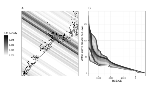
Comparing summed probability distributions of shoreline and radiocarbon dates from the Mesolithic Skagerrak coast of NorwayTaking the Reverend Bayes to the seaside: Improving Norwegian Mesolithic shoreline dating with advanced statistical approachesRecommended by Felix Riede based on reviews by 2 anonymous reviewersThe paper entitled “Comparing summed probability distributions of shoreline and radiocarbon dates from the Mesolithic Skagerrak coast of Norway” by Isak Roalkvam and Steinar Solheim (2024) sheds new light on the degree to which shoreline dating may be used as a reliable chronological and palaeodemographic proxy in the Mesolthic of southern Norway. Based on geologically motivated investigations of eustatic and isostatic sea-level changes, shoreline dating has long been used as a method to date archaeological sites in Scandinavia, not least in Norway (e.g., Bjerck 2008; Astrup 2018). Establishing reliable sea-level curves requires much effort and variations across regions may be substantial. While this topic has seen a great deal of attention in Norway specifically, many purely geological questions remain. In addition, dating archaeological sites by linking their elevation to previously established seal-level curves relies strongly on the foundational assumption that such sites were in fact shore-bound. Given the strong contrast between terrestrial and marine productivity in high-latitude regions such as Norway, this assumption per se is not unreasonable. It is very likely that the sea has played a decisive role in the lives of Stone Age peoples throughout (Persson et al. 2017), just as it has in later periods here. However, many confounding factors relating to both taphonomy and human behaviour are also likely to have loosened the shore/site relationship. Systematic variations driven by cultural norms about settlement location, mobility, as well as factors such as shelter construction, fuel use and a range of other possible factors could variously have impacted the validity or at least the precision of shoreline dating. By developing a new methodology for handling and assessing a large number of shoreline dated sites, Roalkvam and Solheim use state-of-the-art Bayesian statistical methods to compare shoreline and radiocarbon dates as proxies for population activity. The probabilistic treatment of shoreline dates in this way is novel, and the divergences between the two data sets are interpreted by the authors in light of specific behavioural, cultural, and demographic changes. Many of the peaks and troughs observed in these time-series may be interpreted in light of long-observed cultural transitions while others may relate to population dynamics now also visible in palaeogenomic analyses (Günther et al. 2018; Manninen et al. 2021). Overall, this paper makes an innovative and fresh contribution to the use of shoreline dating in Norwegian archaeology, specifically by articulating it with recent developments in Open Science and data-driven approaches to archaeological questions (Marwick et al. 2017). References Astrup, P. M. 2018. Sea-Level Change in Mesolithic Southern Scandinavia : Long- and Short-Term Effects on Society and the Environment. Aarhus: Aarhus University Press. Bjerck, H. B. 2008. Norwegian Mesolithic Trends: A Review. In Mesolithic Europe, edited by Geoff Bailey and Penny Spikins, 60–106. Cambridge: Cambridge University Press. Günther, T., Malmström, H., Svensson, E. M., Omrak, A., Sánchez-Quinto, F., Kılınç, G. M., Krzewińska, M. et al. 2018. Population Genomics of Mesolithic Scandinavia: Investigating Early Postglacial Migration Routes and High-Latitude Adaptation. PLOS Biology 16 (1): e2003703. https://doi.org/10.1371/journal.pbio.2003703 Manninen, M. A., Damlien, H., Kleppe, J. I., Knutsson, K., Murashkin, A., Niemi, A. R., Rosenvinge, C. S. and Persson, P. 2021. First Encounters in the North: Cultural Diversity and Gene Flow in Early Mesolithic Scandinavia. Antiquity 95 (380): 310–28. https://doi.org/10.15184/aqy.2020.252 Marwick, B., d’Alpoim Guedes, J. A., Barton, C. M., Bates, L. A., Baxter, M., Bevan, A., Bollwerk, E. A. et al. 2017. Open Science in Archaeology. The SAA Archaeological Record 17 (4): 8–14. https://doi.org/10.31235/osf.io/72n8g Persson, P., Riede, F., Skar, B., Breivik, H. M. and Jonsson, L. 2017. The Ecology of Early Settlement in Northern Europe: Conditions for Subsistence and Survival. Sheffield: Equinox. Roalkvam, I. and Solheim, S. (2024). Comparing summed probability distributions of shoreline and radiocarbon dates from the Mesolithic Skagerrak coast of Norway, SocArXiv, 2f8ph, ver. 5 peer-reviewed and recommended by Peer Community in Archaeology. https://doi.org/10.31235/osf.io/2f8ph | Comparing summed probability distributions of shoreline and radiocarbon dates from the Mesolithic Skagerrak coast of Norway | Isak Roalkvam, Steinar Solheim | <p>By developing a new methodology for handling and assessing a large number of shoreline dated sites, this paper compares the summed probability distribution of radiocarbon dates and shoreline dates along the Skagerrak coast of south-eastern Norw... | | Computational archaeology, Dating, Europe, Mesolithic, Paleoenvironment | Felix Riede | 2023-09-26 16:43:29 | ||
01 Dec 2022
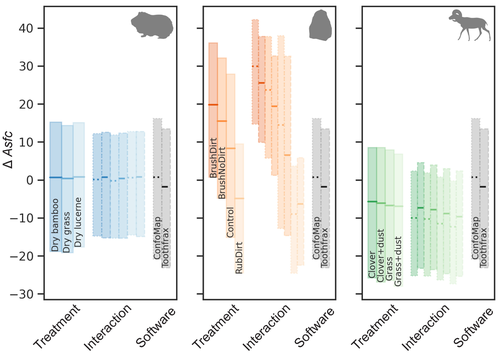
Surface texture analysis in Toothfrax and MountainsMap® SSFA module: Different software packages, different results?An important comparison of software for Scale Sensitive Fractal Analysis : are ancient and new results compatible?Recommended by Alain Queffelec and Florent Rivals based on reviews by Antony Borel and 2 anonymous reviewers
The community of archaeologists, bioanthropologist and paleontologists relying on tools use-wear and dental microwear has grown in the recent years, mainly driven by the spread of confocal microscopes in the laboratories. If the diversity of microscopes is quite high, the main software used for 3D surface texture data analysis are mostly different versions of the same Mountains Map core. In addition to this software, since the beginning of 3D surface texture analysis in dental microwear, surface sensitive fractal analysis (SSFA) initially developed for industrial research (Brown & Savary, 1991) have been performed in our disciplines with the Sfrax/Toothfrax software for two decades (Ungar et al., 2003). This software being discontinued, these calculations have been integrated to the new versions of Mountains Map, with multi-core computing, full integration in the software and an update of the calculation itself. New research based on these standard parameters of surface texture analysis will be, from now on, mainly calculated with this new add-on of Mountains Map, and will be directly compared with the important literature based on the previous software. The question addressed by Calandra et al. (2022), gathering several prominent researchers in this domain including the Mountains Map developer F. Blateyron, is key for the future research: can we directly compare SSFA results from both software? Thanks to a Bayesian approach to this question, and comparing results calculated with both software on three different datasets (two on dental microwear, one on lithic raw materials), the authors show that the two software gives statistically different results for all surface texture parameters tested in the paper. Nevertheless, applying the new calculation to the datasets, they also show that the results published in original studies with these datasets would have been similar. Authors also claim that in the future, researchers will need to re-calculate the fractal parameters of previously published 3D surfaces and cannot simply integrate ancient and new data together. We also want to emphasize the openness of the work published here. All datasets have been published online and will be probably very useful for future methodological works. Authors also published their code for statistical comparison of datasets, and proposed a fully reproducible article that allowed the reviewers to check the content of the paper, which can also make this article of high interest for student training. This article is therefore a very important methodological work for the community, as noted by all three reviewers. It will certainly support the current transition between the two software packages and it is necessary that all surface texture specialists take these results and the recommendation of authors into account: calculate again data from ancient measurements, and share the 3D surface measurements on open access repositories to secure their access in the future. References Brown CA, and Savary G (1991) Describing ground surface texture using contact profilometry and fractal analysis. Wear, 141, 211–226. https://doi.org/10.1016/0043-1648(91)90269-Z Calandra I, Bob K, Merceron G, Blateyron F, Hildebrandt A, Schulz-Kornas E, Souron A, and Winkler DE (2022) Surface texture analysis in Toothfrax and MountainsMap® SSFA module: Different software packages, different results? Zenodo, 7219877, ver. 4 peer-reviewed and recommended by Peer Community in Archaeology. https://doi.org/10.5281/zenodo.7219877 Ungar PS, Brown CA, Bergstrom TS, and Walker A (2003) Quantification of dental microwear by tandem scanning confocal microscopy and scale-sensitive fractal analyses. Scanning: The Journal of Scanning Microscopies, 25, 185–193. https://doi.org/10.1002/sca.4950250405 | Surface texture analysis in Toothfrax and MountainsMap® SSFA module: Different software packages, different results? | Ivan CALANDRA, Konstantin BOB, Gildas MERCERON, François BLATEYRON, Andreas HILDEBRANDT, Ellen SCHULZ-KORNAS, Antoine SOURON, Daniela E. WINKLER | <p>The scale-sensitive fractal analysis (SSFA) of dental microwear textures is traditionally performed using the software Toothfrax. SSFA has been recently integrated to the software MountainsMap® as an optional module. Meanwhile, Toothfrax suppor... | | Computational archaeology, Palaeontology, Traceology | Alain Queffelec | Anonymous, John Charles Willman, Antony Borel | 2022-07-07 09:58:50 |


