Latest recommendations

| Id | Title * | Authors * | Abstract * | Picture * | Thematic fields * | Recommender | Reviewers▲ | Submission date | |
|---|---|---|---|---|---|---|---|---|---|
29 Aug 2023
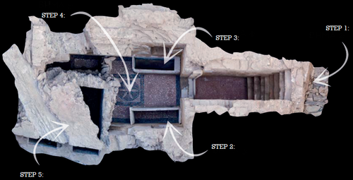
Designing Stories from the Grave: Reviving the History of a City through Human Remains and Serious GamesTsaknaki, Electra; Anastasovitis, Eleftherios; Georgiou, Georgia; Alagialoglou, Kleopatra; Mavrokostidou, Maria; Kartsiakli, Vasiliki; Aidonis, Asterios; Protopsalti, Tania; Nikolopoulos, Spiros; Kompatsiaris, Ioannis https://doi.org/10.5281/zenodo.7981323AR and VR Gamification as a proof-of-conceptRecommended by Sebastian Hageneuer based on reviews by Sophie C. Schmidt and Tine Rassalle based on reviews by Sophie C. Schmidt and Tine Rassalle
Tsaknaki et al. (2023) discuss a work-in-progress project in which the presentation of Cultural Heritage is communicated using Serious Games techniques in a story-centric immersive narration instead of an exhibit-centered presentation with the use of Gamification, Augmented and Virtual Reality technologies. In the introduction the authors present the project called ECHOES, in which knowledge about the past of Thessaloniki, Greece is planned to be processed as an immersive and interactive experience. After presenting related work and the methodology, the authors describe the proposed design of the Serious Game and close the article with a discussion and conclusions. The paper is interesting because it highlights an ongoing process in the realm of the visualization of Cultural Heritage (see for example Champion 2016). The process described by the authors on how to accomplish this by using Serious Games, Gamification, Augmented and Virtual Reality is promising, although still hypothetical as the project is ongoing. It remains to be seen if the proposed visuals and interactive elements will work in the way intended and offer users an immersive experience after all. A preliminary questionnaire already showed that most of the respondents were not familiar with these technologies (AR, VR) and in my experience these numbers only change slowly. One way to overcome the technological barrier however might be the gamification of the experience, which the authors are planning to implement. I decided to recommend this article based on the remarks of the two reviewers, which the authors implemented perfectly, as well as my own evaluation of the paper. Although still in progress it seems worthwhile to have this article as a basis for discussion and comparison to similar projects. However, the article did not mention the possible longevity of data and in which ways the usability of the Serious Game will be secured for long-term storage. One eminent problem in these endeavors is, that we can read about these projects, but never find them anywhere to test them ourselves (see for example Gabellone et al. 2016). It is my intention with this review and the recommendation, that the ECHOES project will find a solution for this problem and that we are not only able to read this (and forthcoming) article(s) about the ECHOES project, but also play the Serious Game they are proposing in the near and distant future. References
Gabellone, Francesco, Antonio Lanorte, Nicola Masini, und Rosa Lasaponara. 2016. „From Remote Sensing to a Serious Game: Digital Reconstruction of an Abandoned Medieval Village in Southern Italy“. Journal of Cultural Heritage. https://doi.org/10.1016/j.culher.2016.01.012 Tsaknaki, Electra, Anastasovitis, Eleftherios, Georgiou, Georgia, Alagialoglou, Kleopatra, Mavrokostidou, Maria, Kartsiakli, Vasiliki, Aidonis, Asterios, Protopsalti, Tania, Nikolopoulos, Spiros, and Kompatsiaris, Ioannis. (2023). Designing Stories from the Grave: Reviving the History of a City through Human Remains and Serious Games, Zenodo, 7981323, ver. 4 peer-reviewed and recommended by Peer Community in Archaeology. https://doi.org/10.5281/zenodo.7981323 | Designing Stories from the Grave: Reviving the History of a City through Human Remains and Serious Games | Tsaknaki, Electra; Anastasovitis, Eleftherios; Georgiou, Georgia; Alagialoglou, Kleopatra; Mavrokostidou, Maria; Kartsiakli, Vasiliki; Aidonis, Asterios; Protopsalti, Tania; Nikolopoulos, Spiros; Kompatsiaris, Ioannis | <p>The main challenge of the current digital transition is to utilize computing media and cutting-edge technologyin a more meaningful way, which would make the archaeological and anthropological research outcomes relevant to a heterogeneous audien... |  | Bioarchaeology, Computational archaeology, Europe | Sebastian Hageneuer | 2023-05-29 13:19:46 | View | |
05 Jan 2024
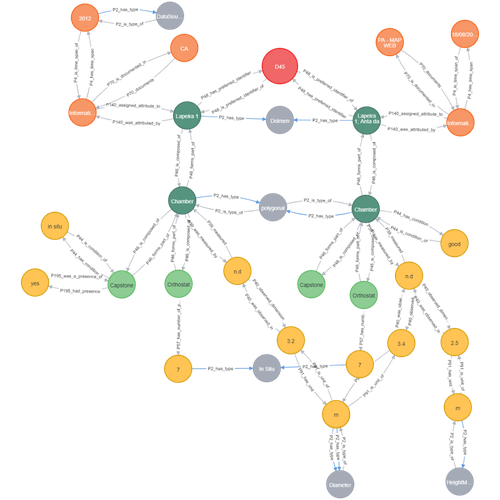
Transforming the CIDOC-CRM model into a megalithic monument property graphAriele Câmara, Ana de Almeida, João Oliveira https://doi.org/10.5281/zenodo.7981230Informative description of a project implementing a CIDOC-CRM based native graph database for representing megalithic informationRecommended by Isto Huvila based on reviews by 2 anonymous reviewersThe paper “Transforming the CIDOC-CRM model into a megalithic monument property graph” describes an interesting endeavour of developing and implementing a CIDOC-CRM based knowledge graph using a native graph database (Neo4J) to represent megalithic information (Câmara et al. 2023). While there are earlier examples of using native graph databases and CIDOC-CRM in diverse heritage contexts, the present paper is useful addition to the literature as a detailed description of an implementation in the context of megalithic heritage. The paper provides a demonstration of a working implementation, and guidance for future projects. The described project is also documented to an extent that the paper will open up interesting opportunities to compare the approach to previous and forthcoming implementations. The same applies to the knowledge graph and use of CIDOC-CRM in the project. Readers interested in comparing available technologies and those who are developing their own knowledge graphs might have benefited of a more detailed description of the work in relation to the current state-of-the-art and what the use of a native graph database in the built-heritage contexts implies in practice for heritage documentation beyond that it is possible and it has potentially meaningful performance-related advantages. While also the reasons to rely on using plain CIDOC-CRM instead of extensions could have been discussed in more detail, the approach demonstrates how the plain CIDOC-CRM provides a good starting point to satisfy many heritage documentation needs. As a whole, the shortcomings relating to positioning the work to the state-of-the-art and reflecting and discussing design choices do not reduce the value of the paper as a valuable case description for those interested in the use of native graph databases and CIDOC-CRM in heritage documentation in general and the documentation of megalithic heritage in particular. ReferencesCâmara, A., de Almeida, A. and Oliveira, J. (2023). Transforming the CIDOC-CRM model into a megalithic monument property graph, Zenodo, 7981230, ver. 4 peer-reviewed and recommended by Peer Community in Archaeology. https://doi.org/10.5281/zenodo.7981230 | Transforming the CIDOC-CRM model into a megalithic monument property graph | Ariele Câmara, Ana de Almeida, João Oliveira | <p>This paper presents a method to store information about megalithic monuments' building components as graph nodes in a knowledge graph (KG). As a case study we analyse the dolmens from the region of Pavia (Portugal). To build the KG, information... |  | Computational archaeology | Isto Huvila | 2023-05-29 13:46:49 | View | |
29 Jan 2024
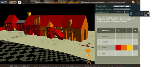
Visual encoding of a 3D virtual reconstruction's scientific justification: feedback from a proof-of-concept researchJ.Y Blaise, I.Dudek, L.Bergerot, G.Simon https://zenodo.org/record/79831633D Models, Knowledge and Visualization: a prototype for 3D virtual models according to plausible criteriaRecommended by Daniel Carvalho based on reviews by Robert Bischoff and Louise TharandtThe construction of 3D realities is deeply embedded in archaeological practices. From sites to artifacts, archaeology has dedicated itself to creating digital copies for the most varied purposes. The paper “Visual encoding of a 3D virtual reconstruction's 3 scientific justification: feedback from a proof-of-concept research” (Jean-Yves et al 2024) represents an advance, in the sense that it does not just deal with a three-dimensional theory for archaeological practice, but rather offers proposals regarding the epistemic component, how it is possible to represent knowledge through the workflow of 3D virtual reconstructions themselves. The authors aim to unite three main axes - knowledge modeling, visual encoding and 3D content reuse - (Jean-Yves et al 2024: 2), which, for all intents and purposes, form the basis of this article. With regard to the first aspect, this work questions how it is possible to transmit the knowledge we want to a 3D model and how we can optimize this epistemic component. A methodology based on plausibility criteria is offered, which, for the archaeological field, offers relevant space for reflection. Given our inability to fully understand the object or site that is the subject of the 3D representation, whether in space or time, building a method based on probabilistic categories is probably one of the most realistic approaches to the realities of the past. Thus, establishing a plausibility criterion allows the user to question the knowledge that is transmitted through the representation, and can corroborate or refute it in future situations. This is because the role of reusing these models is of great interest to the authors, a perfectly justifiable sentiment, as it encourages a critical view of scientific practices. Visual encoding is, in terms of its conjunction with knowledge practices, a key element. The notion of simplicity under Maeda's (2006) design principles not only represents a way of thinking that favors operability, but also a user-friendly design in the prototype that the authors have created. This is also visible when it comes to the reuse of parts of the models, in a chronological logic: adapting the models based on architectural elements that can be removed or molded is a testament to intelligent design, whereby instead of redoing models in their entirety, they are partially used for other purposes. All these factors come together in the final prototype, a web application that combines relational databases (RDBMS) with a data mapper (MassiveJS), using the PHP programming language. The example used is the Marmoutier Abbey hostelry, a centuries-old building which, according to the sources presented, has evolved architecturally over several centuries ((Jean-Yves et al 2024: 8). These states of the building are represented visually through architectural elements based on their existence, location, shape and size, always in terms of what is presented as being plausible. This allows not only the creation of a matrix in which various categories are related to various architectural elements, but also a visual aid, through a chromatic spectrum, of the plausibility that the authors are aiming for. In short, this is an article that seeks to rethink the degree of knowledge we can obtain through 3D visualizations and that does not take models as static, but rather realities that must be explored, recycled and reinterpreted in the light of different data, users and future research. For this reason, it is a work of great relevance to theoretical advances in 3D modeling adapted to archaeology.
References Blaise, J.-Y., Dudek, I., Bergerot, L. and Gaël, S. (2024). Visual encoding of a 3D virtual reconstruction's scientific justification: feedback from a proof-of-concept research, Zenodo, 7983163, ver. 3 peer-reviewed and recommended by Peer Community in Archaeology. https://doi.org/10.5281/zenodo.10496540 John Maeda. (2006). The Laws of Simplicity. MIT Press, Cambridge, MA, USA. | Visual encoding of a 3D virtual reconstruction's scientific justification: feedback from a proof-of-concept research | J.Y Blaise, I.Dudek, L.Bergerot, G.Simon | <p> 3D virtual reconstructions have become over the last decades a classical mean to communicate about analysts’ visions concerning past stages of development of an edifice or a site. However, they still today remain quite often a one-s... |  | Computational archaeology, Spatial analysis | Daniel Carvalho | 2023-05-30 00:43:03 | View | |
13 Jan 2024
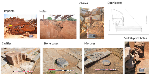
Dealing with post-excavation data: the Omeka S TiMMA web-databaseBastien Rueff https://doi.org/10.5281/zenodo.7989904Managing Archaeological Data with Omeka SRecommended by Jonathan Hanna based on reviews by Electra Tsaknaki and 1 anonymous reviewer based on reviews by Electra Tsaknaki and 1 anonymous reviewer
Managing data in archaeology is a perennial problem. As the adage goes, every day in the field equates to several days in the lab (and beyond). For better or worse, past archaeologists did all their organizing and synthesis manually, by hand, but since the 1970s ways of digitizing data for long term management and analysis have gained increasing attention [1]. It is debatable whether this ever actually made things easier, particularly given the associated problem of sustainable maintenance and accessibility of the data. Many older archaeologists, for instance, still have reels and tapes full of data that now require a new form of archaeology to excavate (see [2] for an unrealized idea on how to solve this). Today, the options for managing digital archaeological data are limited only by one’s imagination. There are systems built specifically for archaeology, such as Arches [3], Ark [4], Codifi [5], Heurist [6], InTerris Registries [7], OpenAtlas [8], S-Archeo [9], and Wild Note [10], as well as those geared towards museum collections like PastPerfect [11] and CatalogIt [12], among others. There are also mainstream databases that can be adapted to archaeological needs like MS Access [13] and Claris FileMaker [14], as well as various web database apps that function in much the same way (e.g., Caspio [15], dbBee [16], Amazon's Simpledb [17], Sci-Note [18], etc.) — all with their own limitations in size, price, and utility. One could also write the code for specific database needs using pre-built frameworks like those in Ruby-On-Rails [19] or similar languages. And of course, recent advances in machine-learning and AI will undoubtedly bring new solutions in the near future. But let’s be honest — most archaeologists probably just use Excel. That's partly because, given all the options, it is hard to decide the best tool and whether its worth changing from your current system, especially given few real-world examples in the literature. Bastien Rueff’s new paper [20] is therefore a welcomed presentation on the use of Omeka S [21] to manage data collected for the Timbers in Minoan and Mycenaean Architecture (TiMMA) project. Omeka S is an open-source web-database that is based in PHP and MySQL, and although it was built with the goal of connecting digital cultural heritage collections with other resources online, it has been rarely used in archaeology. Part of the issue is that Omeka Classic was built for use on individual sites, but this has now been scaled-up in Omeka S to accommodate a plurality of sites. Some of the strengths of Omeka S include its open-source availability (accessible regardless of budget), the way it links data stored elsewhere on the web (keeping the database itself lean), its ability to import data from common file types, and its multi-lingual support. The latter feature was particularly important to the TiMAA project because it allowed members of the team (ranging from English, Greek, French, and Italian, among others) to enter data into the system in whatever language they felt most comfortable. However, there are several limitations specific to Omeka S that will limit widespread adoption. Among these, Omeka S apparently lacks the ability to export metadata, auto-fill forms, produce summations or reports, or provide basic statistical analysis. Its internal search capabilities also appear extremely limited. And that is not to mention the barriers typical of any new software, such as onerous technical training, questionable long-term sustainability, or the need for the initial digitization and formatting of data. But given the rather restricted use-case for Omeka S, it appears that this is not a comprehensive tool but one merely for data entry and storage that requires complementary software to carry out common tasks. As such, Rueff has provided a review of a program that most archaeologists will likely not want or need. But if one was considering adopting Omeka S for a project, then this paper offers critical information for how to go about that. It is a thorough overview of the software package and offers an excellent example of its use in archaeological practice.
[1] Doran, J. E., and F. R. Hodson (1975) Mathematics and Computers in Archaeology. Harvard University Press. [2] Snow, Dean R., Mark Gahegan, C. Lee Giles, Kenneth G. Hirth, George R. Milner, Prasenjit Mitra, and James Z. Wang (2006) Cybertools and Archaeology. Science 311(5763):958–959. [3] https://www.archesproject.org/ [4] https://ark.lparchaeology.com/ [5] https://codifi.com/ [6] https://heuristnetwork.org/ [7] https://www.interrisreg.org/ [8] https://openatlas.eu/ [9] https://www.skinsoft-lab.com/software/archaelogy-collection-management [10] https://wildnoteapp.com/ [11] https://museumsoftware.com/ [12] https://www.catalogit.app/ [13] https://www.microsoft.com/en-us/microsoft-365/access [14] https://www.claris.com/filemaker/ [15] https://www.caspio.com/ [16] https://www.dbbee.com/ [17] https://aws.amazon.com/simpledb/ [18] https://www.scinote.net/ [19] https://rubyonrails.org/ [20] Rueff, Bastien (2023) Dealing with Post-Excavation Data: The Omeka S TiMMA Web-Database. peer-reviewed and recommended by Peer Community in Archaeology. https://zenodo.org/records/7989905 [21] https://omeka.org/
| Dealing with post-excavation data: the Omeka S TiMMA web-database | Bastien Rueff | <p>This paper reports on the creation and use of a web database designed as part of the TiMMA project with the Content Management System Omeka S. Rather than resulting in a technical manual, its goal is to analyze the relevance of using Omeka S in... |  | Buildings archaeology, Computational archaeology | Jonathan Hanna | 2023-05-31 12:16:25 | View | |
06 Oct 2023
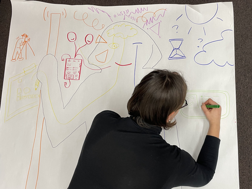
Body Mapping the Digital: Visually representing the impact of technology on archaeological practice.Araar, Leila; Morgan, Colleen; Fowler, Louise https://doi.org/10.5281/zenodo.7990581Understanding archaeological documentation through a participatory, arts-based approachRecommended by Nicolo Dell'Unto based on reviews by 2 anonymous reviewersThis paper presents the use of a participatory arts-based methodology to understand how digital and analogue tools affect individuals' participation in the process of archaeological recording and interpretation. The preliminary results of this work highlight the importance of rethinking archaeologists' relationship with different recording methods, emphasising the need to recognise the value of both approaches and to adopt a documentation strategy that exploits the strengths of both analogue and digital methods. Although a larger group of participants with broader and more varied experience would have provided a clearer picture of the impact of technology on current archaeological practice, the article makes an important contribution in highlighting the complex and not always easy transition that archaeologists trained in analogue methods are currently experiencing when using digital technology. This is assessed by using arts-based methodologies to enable archaeologists to consider how digital technologies are changing the relationship between mind, body and practice. I found the range of experiences described in the papers by the archaeologists involved in the experiment particularly interesting and very representative of the change in practice that we are all experiencing. As the article notes, the two approaches cannot be directly compared because they offer different possibilities: if analogue methods foster a deeper connection with the archaeological material, digital documentation seems to be perceived as more effective in terms of data capture, information exchange and data sharing (Araar et al., 2023). It seems to me that an important element to consider in such a study is the generational shift and the incredible divide between native and non-native digital. The critical issues highlighted in the paper are central and provide important directions for navigating this ongoing (digital) transition. References Araar, L., Morgan, C. and Fowler, L. (2023) Body Mapping the Digital: Visually representing the impact of technology on archaeological practice., Zenodo, 7990581, ver. 5 peer-reviewed and recommended by Peer Community in Archaeology. https://doi.org/10.5281/zenodo.7990581 | Body Mapping the Digital: Visually representing the impact of technology on archaeological practice. | Araar, Leila; Morgan, Colleen; Fowler, Louise | <p>This paper uses a participatory, art-based methodology to understand how digital and analog tools impact individuals' experience and perceptions of archaeological recording. Body mapping involves the co-creation of life-sized drawings and narra... |  | Computational archaeology, Theoretical archaeology | Nicolo Dell'Unto | 2023-06-01 09:06:52 | View | |
02 Apr 2024
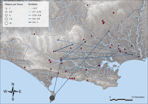
Similarity Network Fusion: Understanding Patterns and their Spatial Significance in Archaeological DatasetsTimo Geitlinger https://doi.org/10.5281/zenodo.7998239A different approach to similarity networks in Archaeology - Similarity Network FusionRecommended by Joel Santos based on reviews by Matthew Peeples and 1 anonymous reviewerThis is a fascinating paper for anyone interested in network analysis or the chronology and cultures of the case study, namely the Late prehistoric burial sites in Dorset, for which the author’s approach allowed a new perspective over an already deeply studied area [1]. This paper's implementation of Similarity Network Fusion (SNF) is noteworthy. This method is typically utilized within genetic research but has yet to be employed in Archaeology. SNF has the potential to benefit Archaeology due to its unique capabilities and approach significantly. The author exhibits a deep and thorough understanding of previous investigations concerning material and similarity networks while emphasizing the innovative nature of this particular study. The SNF approach intends to improve a lack of the most used (in Archaeology) similarity coefficient, the Brainerd-Robinson, in certain situations, mainly in heterogenous and noisy datasets containing a small number of samples but a large number of measurements, scale differences, and collection biases, among other things. The SNF technique, demonstrated in the case study, effectively incorporates various similarity networks derived from different datatypes into one network. As shown during the Dorset case study, the SNF application has a great application in archaeology, even in already available data, allowing us to go further and bring new visions to the existing interpretations. As stated by the author, SNF shows its potential for other applications and fields in archaeology coping with similar datasets, such as archaeobotany or archaeozoology, and seems to complement different multivariate statistical approaches, such as correspondence or cluster analysis. This paper has been subject to two excellent revisions, which the author mostly accepted. One of the revisions was more technical, improving the article in the metadata part, data availability and clarification, etc. Although the second revision was more conceptual and gave some excellent technical inputs, it focused more on complementary aspects that will allow the paper to reach a wider audience. I vividly recommend its publication. References [1] Geitlinger, T. (2024). Similarity Network Fusion: Understanding Patterns and their Spatial Significance in Archaeological Datasets. Zenodo, 7998239, ver. 3 peer-reviewed and recommended by Peer Community in Archaeology. https://doi.org/10.5281/zenodo.7998239
| Similarity Network Fusion: Understanding Patterns and their Spatial Significance in Archaeological Datasets | Timo Geitlinger | <p>Since its earliest application in the 1970s, network analysis has become increasingly popular in both theoretical and GIS-based archaeology. Yet, applications of material networks remained relatively restricted. This paper describes a specific ... |  | Computational archaeology, Protohistory | Joel Santos | 2023-06-02 16:51:19 | View | |
07 May 2024
Mobility and the reuse of Roman Roads for the deposition of Viking Age silver hoards in North West EnglandWyatt Wilcox https://doi.org/10.5281/zenodo.7999149Moving away from the ritual deposition: hoards from the Viking Age, Least Cost Paths and reused Roman RoadsRecommended by Ronald Visser based on reviews by Sam Leggett and Scott Madry based on reviews by Sam Leggett and Scott Madry
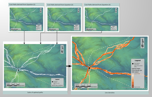
I had the pleasure of reading ‘Mobility and the reuse of Roman Roads for the deposition of Viking Age silver hoards in North West England’ by Wyatt O. Wilcox (Wilcox 2024a). It is an honour to recommend this paper. The aim of this study is to research the relationship of 18 Viking Age hoards and their transport and depositional locations. This is studied in relation to the Roman road network and the landscape using least cost path analyses. Single finds from the Portable Antiquities Scheme (https://finds.org.uk/) are also incorporated in the study. The study deals with the distance of these Viking Age finds to these roads/least-cost-paths and the final interpretation moves away from ritual interpretation of these finds to a more mundane explanation. I feel that this could potentially open discussion also for hoards from other periods. While both reviewers (Sam Leggett and Scott Madry) presented various suggestions to improve the first submitted version of the paper, the author has done a tremendous job to improve the paper based on the comments and even beyond these comments. The author has also deposited the Jypiter-notebook online (Wilcox 2024b), showing that he is contributing to Open Science. The first version of the dataset has been improved and updated based on the comments by the reviewers and me, improving the reproducibility of the analyses. All in all, this paper has improved and I am very glad that I can recommend this for publication, and I’d like to do so with a sentence from the review by Sam Leggett: “this study has a lot of potential to be deployed across other regions, and time periods for similar purposes (Iron Age hoards for instance). And it will be of great interest to Viking Age experts interested in hoards, but also early medieval transport and travel.” References Wilcox, W. 2024a Mobility and the reuse of Roman Roads for the deposition of Viking Age silver hoards in North West England. Zenodo, 7999149, ver. 5 peer-reviewed and recommended by Peer Community in Archaeology. https://doi.org/10.5281/zenodo.7999149 Wilcox, W. 2024b Mobility and the reuse of Roman Roads for the deposition of Viking Age silver hoards in North West England (Supplemental Material). https://doi.org/10.5281/zenodo.11067607 | Mobility and the reuse of Roman Roads for the deposition of Viking Age silver hoards in North West England | Wyatt Wilcox | <p>Discussions on Viking Age silver hoards in North West England have been dominated by analysis of the material compositions of the hoards. Despite a multi-century research legacy concerning the material composition of the Viking Age silver... |  | Europe, Landscape archaeology, Medieval, Spatial analysis | Ronald Visser | 2023-06-04 22:29:18 | View | |
02 Feb 2024
Implementing Digital Documentation Techniques for Archaeological Artifacts to Develop a Virtual Exhibition: the Necropolis of Baley CollectionRaykovska Miglena, Jones Kristen, Klecherova Hristina, Alexandrov Stefan, Petkov Nikolay, Hristova Tanya, Ivanov Georgi https://doi.org/10.5281/zenodo.8027548Out of the storeroom and into the virtualRecommended by Jitte Waagen based on reviews by Alicia Walsh and 1 anonymous reviewer based on reviews by Alicia Walsh and 1 anonymous reviewer
This paper (Raykovska et al. 2023) discusses the digital documentation techniques and development of a virtual exhibition for artefacts retrieved from the necropolis of Baley, Bulgaria. The principal aim of this particular project is a solid one, trying to provide a solution to display artefacts that would otherwise remain hidden in museum storerooms. The paper describes how through a combination of 3D scanning and photogrammetry high quality 3D models have been produced, and provide content for an online virtual exhibition for the scientific community but also the larger public. It is a well-written and concise paper, in which the information on developed methods and techniques are transparently described, and various important aspects of digitization workflows, such as the importance of storing raw data, are addressed. The paper is a timely discussion on this subject, as strategies to develop digital artefact collections and what to do with those are increasingly being researched. Specifically, it discusses a workflow and its results, both in great detail. Although critical reflection on the process, goals and results from various perspectives would have been a valuable addition to the paper (cf., Jeffra 2020, Paardekoper 2019), it nonetheless provides a good practice example of how to approach the creation of a virtual museum. Those who consider projects concerning digital documentation of archaeological artefacts as well as the creation of virtual spaces to use those in for research, education or valorisation purposes would do well to read this paper carefully. References Jeffra, C., Hilditch, J., Waagen, J., Lanjouw, T., Stoffer, M., de Gelder, L., and Kim, M. J. (2020). Blending the Material and the Digital: A Project at the Intersection of Museum Interpretation, Academic Research, and Experimental Archaeology. The EXARC Journal, 2020(4). https://exarc.net/ark:/88735/10541 Paardekooper, R.P. (2019). Everybody else is doing it, so why can’t we? Low-tech and High-tech approaches in archaeological Open-Air Museums. The EXARC Journal, 2019(4). https://exarc.net/ark:/88735/10457/ Raykovska, M., Jones, K., Klecherova, H., Alexandrov, S., Petkov, N., Hristova, T., and Ivanov, G. (2023). Implementing Digital Documentation Techniques for Archaeological Artifacts to Develop a Virtual Exhibition: the Necropolis of Baley Collection. https://doi.org/10.5281/zenodo.10091870 | Implementing Digital Documentation Techniques for Archaeological Artifacts to Develop a Virtual Exhibition: the Necropolis of Baley Collection | Raykovska Miglena, Jones Kristen, Klecherova Hristina, Alexandrov Stefan, Petkov Nikolay, Hristova Tanya, Ivanov Georgi | <p>Over the past decade, virtual reality has been quickly growing in popularity across disciplines including the field of archaeology and cultural heritage. Despite numerous artifacts being uncovered each year by archaeological excavations around ... |  | Ceramics, Computational archaeology, Conservation/Museum studies | Jitte Waagen | 2023-06-12 14:02:44 | View | |
02 May 2024
ARIADNEplus Visual Media Service 3D configurator: toward full guided publication of high-resolution 3D dataPotenziani, Marco; Ponchio, Federico; Callieri, Marco; Cignoni, Paolo https://doi.org/10.5281/zenodo.8075050ARIADNEplus Visual Media Service 3D configurator: a new tool for the visual organisation of 3D datasetsRecommended by Ian Moffat based on reviews by Sebastian Hageneuer, Vayia Panagiotidis, Erik Champion and Martina Trognitz based on reviews by Sebastian Hageneuer, Vayia Panagiotidis, Erik Champion and Martina Trognitz
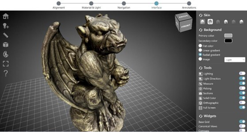
The manuscript "ARIADNEplus Visual Media Service 3D configurator: toward full guided publication of high-resolution 3D data" by Potenziani et al. [1] provides an excellent introduction to the Visual Media Service 3D Configurator. This is an exciting tool, focused on cultural heritage, that forms part of the Visual Media Service, a web-based platform for uploading a range of complex data sets, including high-resolution images, Reflectance Transformation Imaging images and 3D models and transforming them into an appropriate format for interation and visualisation on the web. The 3D Configurator Tool provides researchers with a wizard which assist with the presentation of 3D models. This manuscript provides a history and context for the development of the Visual Media Service and previous related tools such as 3DHOP, Nexus and Relight/OpenLIME. It also provides detailed information about the functionality of the 3D Configurator, including the Alignment, Material & Light, Navigation, Interface and Annotation steps. The Discussion section provides information about applications and users of the Visual Media Service, current limitations and planned future developments. Reviewers Hageneuer, Champion, Trognitz and Panagiotidis all provided important suggestions to the authors which have improved the clarity and scope of this manuscript. While this manscript does not present a case study using this tool, I recommend it to readers as a detailed and clear introduction to the Visual Media Service 3D configurator which may inspire them to use this for their own research. [1] Potenziani, M., Ponchio, F., Callieri, M., and Cignoni, P. (2024). ARIADNEplus Visual Media Service 3D configurator: toward full guided publication of high-resolution 3D data. Zenodo, 8075050, ver. 5 peer-reviewed and recommended by Peer Community in Archaeology. https://doi.org/10.5281/zenodo.10894515 | ARIADNEplus Visual Media Service 3D configurator: toward full guided publication of high-resolution 3D data | Potenziani, Marco; Ponchio, Federico; Callieri, Marco; Cignoni, Paolo | <p>The use of digital visual media in everyday work is nowadays a common practice in many different domains, including Cultural Heritage (CH). Because of that, the presence of digital datasets in CH archives and repositories is becoming more and m... |  | Computational archaeology | Ian Moffat | 2023-06-23 17:37:47 | View | |
12 Apr 2024
Survey Planning, Allocation, Costing and Evaluation (SPACE) Project: Developing a Tool to Help Archaeologists Conduct More Effective SurveysE. B. Banning, Steven Edwards, and Isaac Ullah https://doi.org/10.5281/zenodo.8072178A new tool to increase the robustness of archaeological field surveyRecommended by Jitte Waagen based on reviews by Philip Verhagen and Tymon de Haas based on reviews by Philip Verhagen and Tymon de Haas
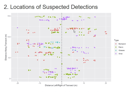
This well-written and interesting paper ‘Survey Planning, Allocation, Costing and Evaluation (SPACE) Project: Developing a Tool to Help Archaeologists Conduct More Effective Surveys’ deals with the development of a ‘modular, accessible, and simple web-based platform for survey planning and quality assurance’ in the area of pedestrian field survey methods (Banning et al. 2024). Although there have been excellent treatments of statistics in archaeological field survey (among which various by the first author: Banning 2020, 2021), and there is continuous methodological debate on platforms such as the International Mediterranean Survey Workshop (IMSW), in papers dealing with the current development and state of the field (Knodell et al. 2023), good practices (Attema et al. 2020) or the merits of a quantifying approach to archaeological densities (cf. de Haas et al. 2023), this paper rightfully addresses the lack of rigorous statistical approaches in archaeological field survey. As argued by several scholars such as Orton (2000), this mainly appears the result of lack of knowledge/familiarity/resources to bring in the required expertise etc. with the application of seemingly intricate statistics (cf. Waagen 2022). In this context this paper presents a welcome contribution to the feasibility of a robust archaeological field survey design. The SPACE application, under development by the authors, is introduced in this paper. It is a software tool that aims to provide different modules to assist archaeologists to make calculations for sample size, coverage, stratification, etc. under the conditions of survey goals and available resources. In the end, the goal is to ensure archaeological field surveys will attain their objectives effectively and permit more confidence in the eventual outcomes. The module concerning Sweep Widths, an issue introduced by the main author in 2006 (Banning 2006) is finished; the sweep width assessment is a methodology to calibrate one’s survey project for artefact types, landscape, visibility and person-bound performance, eventually increasing the quality (comparability) of the collected samples. This is by now a well-known calibration technique, yet little used, so this effort to make that more accessible is certainly laudable. An excellent idea, and another aim of this project, is indeed to build up a database with calibration data, so applying sweep-width corrections will become easier accessible to practitioners who lack time to set up calibration exercises. It will be very interesting to have a closer look at the eventual platform and to see if, and how, it will be adapted by the larger archaeological field survey community, both from an academic research perspective as from a heritage management point of view. I happily recommend this paper and all debate relating to it, including the excellent peer reviews of the manuscript by Philip Verhagen and Tymon de Haas (available as part of this PCI recommendation procedure), to any practitioner of archaeological field survey. References Attema, P., Bintliff, J., Van Leusen, P.M., Bes, P., de Haas, T., Donev, D., Jongman, W., Kaptijn, E., Mayoral, V., Menchelli, S., Pasquinucci, M., Rosen, S., García Sánchez, J., Luis Gutierrez Soler, L., Stone, D., Tol, G., Vermeulen, F., and Vionis. A. 2020. “A guide to good practice in Mediterranean surface survey projects”, Journal of Greek Archaeology 5, 1–62. https://doi.org/10.32028/9781789697926-2 Banning, E.B., Alicia L. Hawkins, S.T. Stewart, Sweep widths and the detection of artifacts in archaeological survey, Journal of Archaeological Science, Volume 38, Issue 12, 2011, Pages 3447-3458. https://doi.org/10.1016/j.jas.2011.08.007 Banning, E.B. 2020. Spatial Sampling. In: Gillings, M., Hacıgüzeller, P., Lock, G. (eds.) Archaeological Spatial Analysis. A Methodological Guide. Routledge. Banning, E.B. 2021. Sampled to Death? The Rise and Fall of Probability Sampling in Archaeology. American Antiquity, 86(1), 43-60. https://doi.org/10.1017/aaq.2020.39 Banning, E. B. Steven Edwards, & Isaac Ullah. (2024). Survey Planning, Allocation, Costing and Evaluation (SPACE) Project: Developing a Tool to Help Archaeologists Conduct More Effective Surveys. Zenodo, 8072178, ver. 9 peer-reviewed and recommended by Peer Community in Archaeology. https://doi.org/10.5281/zenodo.8072178 Knodell, A.R., Wilkinson, T.C., Leppard, T.P. et al. 2023. Survey Archaeology in the Mediterranean World: Regional Traditions and Contributions to Long-Term History. J Archaeol Res 31, 263–329 (2023). https://doi.org/10.1007/s10814-022-09175-7 Orton, C. 2000. Sampling in Archaeology. Cambridge University Press. https://doi.org/10.1017/CBO9781139163996 Waagen, J. 2022. Sampling past landscapes. Methodological inquiries into the bias problems of recording archaeological surface assemblages. PhD-Thesis. https://hdl.handle.net/11245.1/e9cb922c-c7e4-40a1-b648-7b8065c46880 de Haas, T., Leppard, T. P., Waagen, J., & Wilkinson, T. (2023). Myopic Misunderstandings? A Reply to Meyer (JMA 35(2), 2022). Journal of Mediterranean Archaeology, 36(1), 127-137. https://doi.org/10.1558/jma.27148 | Survey Planning, Allocation, Costing and Evaluation (SPACE) Project: Developing a Tool to Help Archaeologists Conduct More Effective Surveys | E. B. Banning, Steven Edwards, and Isaac Ullah | <p>Designing an effective archaeological survey can be complicated and confidence that it was effective requires post-survey evaluation. The goal of SPACE is to develop software to facilitate survey designers’ decisions and partially automate tool... |  | Computational archaeology, Landscape archaeology | Jitte Waagen | 2023-06-28 13:42:28 | View |
MANAGING BOARD
Alain Queffelec
Marta Arzarello
Ruth Blasco
Otis Crandell
Luc Doyon
Sian Halcrow
Emma Karoune
Aitor Ruiz-Redondo
Philip Van Peer


