
Latest recommendations

| Id | Title * | Authors * | Abstract * | Picture * | Thematic fields * | Recommender | Reviewers | Submission date▲ | |
|---|---|---|---|---|---|---|---|---|---|
29 Apr 2024

Study and enhancement of the heritage value of a fortified settlement along the Limes Arabicus. Umm ar-Rasas (Amman, Jordan) between remote sensing analysis, photogrammetry and laser scanner surveys.Integrating remote sensing and photogrammetric approaches to studying a fortified settlement along the Limes Arabicus: Umm ar‐Rasas (Amman, Jordan).Recommended by Alessia Brucato based on reviews by Francesc C. Conesa, Giuseppe Ceraudo and 1 anonymous reviewerDi Palma et alii manuscript delves into applying remote sensing and photogrammetry methods to document and analyze the castrum at the Umm er-Rasas site in Jordan. This research aimed to map all the known archaeological evidence, detect new historical structures, and create a digital archive of the site's features for study and education purposes [1]. Their research has been organized into two phases. The first one consisted of a remote sensing survey and involved collecting historical and modern aerial and satellite imagery, such as: aerial photographs by Sir Marc Aurel Stein from 1939; panchromatic spy satellite images from the Cold War period (Corona KH-4B and Hexagon KH-9); high and very high resolution (HR and VHR) modern multispectral satellite images (Pléiades-1A and Pléiades Neo-4) [1]. This dataset was processed using the ENVI 4.4 software and applying multiple image-enhancing techniques (Pansharpening, RGB composite, data fusion, and Principal Component Analysis). Then, the resulting images were integrated into a QGIS project, allowing for visual analyses of the site's features and terrain. These investigations provided: · a broad overview of the site, · the discovery of a previously unknown archaeological feature (the northeastern dam), · a stage for targeted ground-level investigations [1]. The project's second phase was dedicated to intensive fieldwork operations, including pedestrian surveys, stratigraphic excavations, and photogrammetric recordings, such as: photographic reconstructions via Structure from Motion (SfM) and laser scanner sessions (using two FARO X330 HDR). In particular, the laser scanner data were processed with Reconstructor 4.4, which provided highly detailed 3D models for the QGIS database. These results were crucial in validating the information acquired during the first phase. Overall, the paper is well written, with clear objectives and a systematic presentation of the site [2,3,10,11], the research materials, and the study phases. The dataset was described in meticulous detail (especially the remote sensing sources and the laser scanner recordings). The methods implemented in this study are rigorously described [4,5,6,7,8,9] and show a high level of integration between aerial and field techniques. The results are neatly illustrated and fit into the current debates about the efficacy of remote sensing detection and multiscale approaches in archaeological research. In conclusion, this manuscript significantly contributes to archaeological research, unveiling new and exciting findings about the site of Umm er-Rasas. Its findings and methodologies warrant publication and further exploration. References: 1. Di Palma, F., Gabrielli, R., Merola, P., Miccoli, I. and Scardozzi, G. (2024). Study and enhancement of the heritage value of a fortified settlement along the Limes Arabicus. Umm ar-Rasas (Amman, Jordan) between remote sensing analysis, photogrammetry and laser scanner surveys. Zenodo, 8306381, ver. 3 peer-reviewed and recommended by Peer Community in Archaeology. https://doi.org/10.5281/zenodo.8306381 2. Abela J. and Acconci A. (1997), Umm al‐Rasas Kastron Mefa’a. Excavation Campaign 1997. Church of St. Paul: northern and southern flanks. Liber Annus, 47, 484‐488. 3. Bujard J. (2008), Kastron Mefaa, un bourg à l'époque byzantine: Travaux de la Mission archéologique de la Fondation Max van Berchem à Umm al‐Rasas, Jordanie (1988‐1997), PhD diss., University of Fribourg 2008. 4. Cozzolino M., Gabrielli R., Galatà P., Gentile V., Greco G., Scopinaro E. (2019), Combined use of 3D metric surveys and non‐invasive geophysical surveys at the stylite tower (Umm ar‐Rasas, Jordan), Annals of geophysics, 62, 3, 1‐9. http://dx.doi.org/10.4401/ag‐8060 5. Gabrielli R., Salvatori A., Lazzari A., Portarena D. (2016), Il sito di Umm ar‐Rasas – Kastron Mefaa – Giordania. Scavare documentare conservare, viaggio nella ricerca archeologica del CNR. Roma 2016, 236‐240. 6. Gabrielli R., Portarena D., Franceschinis M. (2017), Tecniche di documentazione dei tappeti musivi del sito archeologico di Umm al‐Rasas Kastron Mefaa (Giordania). Archeologia e calcolatori, 28 (1), 201‐218. https://doi.org/10.19282/AC.28.1.2017.12 7. Lasaponara R., Masini N. (2012 ed.), Satellite Remote Sensing: A New Tool for Archaeology, New York 2012. 8. Lasaponara R., Masini N. and Scardozzi G. (2007), Immagini satellitari ad alta risoluzione e ricerca archeologica: applicazioni e casi di studio con riprese pancromatiche e multispettrali di QuickBird. Archeologia e Calcolatori, 18 (2), 187‐227. https://core.ac.uk/download/pdf/33150351.pdf 9. Lasaponara R., Masini N., Scardozzi G. (2010), Elaborazioni di immagini satellitari ad alta risoluzione e ricognizione archeologica per la conoscenza degli insediamenti rurali del territorio di Hierapolis di Frigia (Turchia). Il dialogo dei Saperi – Metodologie integrate per i Beni Culturali, Edizioni scientifiche italiane, 479‐494. 10. Piccirillo M., Abela J. and Pappalardo C. (2007), Umm al‐Rasas ‐ campagna 2007. Rapporto di scavo. Liber Annus, 57, 660‐668. 11. Poidebard A. (1934), La trace de Rome dans le désert de Syrie : le limes de Trajan à la conquête arabe ; recherches aériennes 1925 – 1932. Paris : Geuthner. | Study and enhancement of the heritage value of a fortified settlement along the Limes Arabicus. Umm ar-Rasas (Amman, Jordan) between remote sensing analysis, photogrammetry and laser scanner surveys. | Di Palma Francesca, Gabrielli Roberto, Merola Pasquale, Miccoli Ilaria, Scardozzi Giuseppe | <p>The Limes Arabicus is an excellent laboratory for experimenting with the huge potential of historical remote sensing data for identifying and mapping fortified centres along this sector of the eastern frontier of the Roman Empire and then the B... | | Antiquity, Asia, Classic, Landscape archaeology, Mediterranean, Remote sensing, Spatial analysis | Alessia Brucato | 2023-08-31 23:34:16 | ||
02 May 2024
Machine Learning for UAV and Ground-Captured Imagery: Toward Standard PracticesA step forward in detecting small objects in UAV data for archaeological surveyingRecommended by Alex Brandsen based on reviews by 2 anonymous reviewers based on reviews by 2 anonymous reviewers
In this paper [1], the authors describe how they apply machine learning with YOLOv5 to classify visual data, aiming to enhance understanding of archaeological phenomena before conducting destructive fieldwork. Despite challenges, the integration of machine learning with remote sensing technology was seen as transformative, enabling precise recording of areas of interest and assessment of environmental risk factors. The paper discusses successes, failures, and future directions in machine learning research, emphasising the need for standardisation and integration of streamlined methods. The application of machine learning techniques facilitates non-destructive analysis of material culture records, improving conservation efforts and offering insights into both past and contemporary phenomena. While the initial use of YOLOv5 showed potential for consistent detection of archaeological features, further refinement and dataset enlargement are deemed necessary for broader application in non-destructive archaeological surveying. The authors advocate for the integration of machine learning tools in archaeological research to save time, resources, and promote ethical digital recording practices. They highlight the importance of standardised methodologies to enhance credibility and reproducibility, aiming to contribute to the ongoing dialogue in computational archaeology. Overall, I think this paper is a good step forward in detecting small objects in UAV data, and contains useful information for similar studies. The aim towards greater reproducibility and standardisation is of course shared more widely in the machine learning community, and this study is a good example of how to approach this. References [1] Sharp, K., Christofis, B., Eslamiat, H., Nepal, U. and Osores Mendives, C. (2024). Machine Learning for UAV and Ground-Captured Imagery: Toward Standard Practices. Zenodo, 8307612, ver. 5 peer-reviewed and recommended by Peer Community in Archaeology. https://doi.org/10.5281/zenodo.8307612 | Machine Learning for UAV and Ground-Captured Imagery: Toward Standard Practices | Sharp Kayeleigh, Christofis Brooklyn, Eslamiat Hossein, Nepal Upesh, Osores Mendives Carlos | <p>Our collaborative work began in 2019 with the intent to overcome obstacles that had arisen from the inability to access curated artifact collections from remote locations. It was our specific aim to not only create digital twins of excavated ob... | | Ceramics, Computational archaeology, Remote sensing, South America | Alex Brandsen | 2023-09-01 09:56:18 | ||
02 Apr 2024
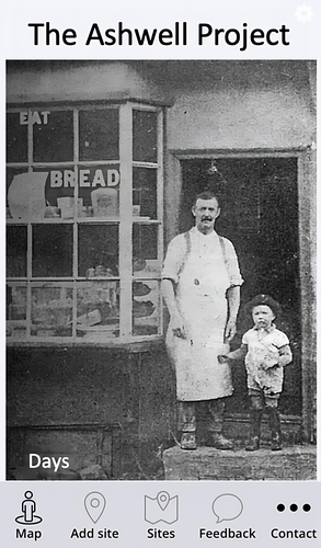
The Ashwell Project: Creating an Online Geospatial CommunityA nice project looking at under-represented demographicRecommended by Alexis Pantos based on reviews by Catriona Cooper and Steinar Kristensen
The paper by A. Lien-Talks [1] presents a small project looking at the use of crowd sourced data collection and particpatory GIS. In particular it looks at the potential of these tools in response to socially disruptive and isolating events such as the COVID-19 pandemic as well as the potential role of digitially mediated heritage initiatives in tackling some of the challenges of changing demographics and life styles. The types of technologies employed are relatively mature, the project identifies potential for such approaches to be used within the local-history/local community settings, though is also a reminer that depsite the much broader adoption of technology within all areas of society than even a few years ago many barriers still remain. While the the sample size and data collected in the project is relatively modest, the focus on empathy toward the intended audiences from the design process, as well as some of the qualitative feedback reported serve as a reminder that participatory, or crowd-sourced data collection initiatives in heritage can, and perhaps should place potential social benefit before data-acquisition of objectives. The project also presents a demographic that is not often represented within the literature and the publication and as such the publication of the article represents a meaningful contribution to ongoing discussions of the role heritage and digitally mediated community archaeology can play a role in developing our societies. References [1] Lien-Talks, A. (2024). The Ashwell Project: Creating an Online Geospatial Community. Zenodo, 8307882, ver. 4 peer-reviewed and recommended by Peer Community in Archaeology. https://doi.org/10.5281/zenodo.8307882 | The Ashwell Project: Creating an Online Geospatial Community | Alphaeus Lien-Talks | <p>Background:<br>As the world becomes increasingly digital, so too must the way in which archaeologists engage with the public. This was particularly important during the COVID-19 pandemic, and many outreach and engagement efforts began to move o... | | Computational archaeology | Alexis Pantos | 2023-09-01 11:25:54 | ||
03 Feb 2024
Digital surface models of crops used in archaeological feature detection – a case study of Late Neolithic site Tomašanci-Dubrava in Eastern CroatiaWhat lies on top lies also beneath? Connecting crop surface modelling to buried archaeology mapping.Recommended by Markos Katsianis based on reviews by Ian Moffat and Geert Verhoeven
This paper (Sosic et al. 2024) explores the Neolithic landscape of the Sopot culture in Đakovština, Eastern Slavonija, revealing a network of settlements through a multi-faceted approach that combines aerial archaeology, magnetometry, excavation, and field survey. This strategy facilitates scalable research tailored to the particularities of each site and allows for improved representations of buried archaeology with minimal intrusion. Using the site of Tomašanci-Dubrava as an example of the overall approach, the study further explores the use of drone imagery for 3D surface modeling, revealing a consistent correlation between crop surface elevation during full plant growth and ground terrain after ploughing, attributed to subsurface archaeological features. Results are correlated with magnetic survey and test-pitting data to validate the micro-topography and clarify the relationship between different subsurface structures. The results obtained are presented in a comprehensive way, including their source data, and are contextualized in relation to conventional cropmark detection approaches and expectations. I found this aspect very interesting, since the crop surface and terrain models contradict typical or textbook examples of cropmark detection, where the vegetation is projected to appear higher in ditches and lower in areas with buried archaeology (Renfrew & Bahn 2016, 82). Regardless, the findings suggest the potential for broader applications of crop surface or canopy height modelling in landscape wide surveys, utilizing ALS data or aerial photographs. It seems then that the authors make a valid argument for a layered approach in landscape-based site detection, where aerial imagery can be used to accurately map the topography of areas of interest, which can then be further examined at site scale using more demanding methods, such as geophysical survey and excavation. This scalability enhances the research's relevance in broader archaeological and geographical contexts and renders it a useful example in site detection and landscape-scale mapping. References Renfrew, C. and Bahn, P. (2016). Archaeology: theories, methods and practice. Thames and Hudson. Sosic Klindzic, R., Vuković, M., Kalafatić, H. and Šiljeg, B. (2024). Digital surface models of crops used in archaeological feature detection – a case study of Late Neolithic site Tomašanci-Dubrava in Eastern Croatia, Zenodo, 7970703, ver. 4 peer-reviewed and recommended by Peer Community in Archaeology. https://doi.org/10.5281/zenodo.7970703 | Digital surface models of crops used in archaeological feature detection – a case study of Late Neolithic site Tomašanci-Dubrava in Eastern Croatia | Sosic Klindzic Rajna; Vuković Miroslav; Kalafatić Hrvoje; Šiljeg Bartul | <p>This paper presents the results of a study on the neolithic landscape of the Sopot culture in the area of Đakovština in Eastern Slavonija. A vast network of settlements was uncovered using aerial archaeology, which was further confirmed and chr... | | Landscape archaeology, Neolithic, Remote sensing, Spatial analysis | Markos Katsianis | 2023-09-01 12:57:04 | ||
22 Apr 2024
The transformation of an archaeological community and its resulting representations in the context of the co-development of open Archaeological Information SystemsExploring The Role of Archaeological Information Systems in Improving Data Management and InteroperabilityRecommended by James Stuart Taylor based on reviews by 2 anonymous reviewers
In response to the feedback provided by the reviewers, the authors have undertaken a comprehensive revision of the manuscript [1]. These revisions have specifically targeted the primary concerns raised regarding the clarity and structure of the argument concerning the transformative impact of Archaeological Information Systems (AIS) on archaeological practices. In my view the revised manuscript now more clearly articulates the distinction between internal and external interoperability and emphasizes the critical importance of integrating contextual information with archaeological data. This approach directly addresses the previously identified need for enhanced traceability and usability of archaeological data, ensuring that the manuscript's contributions to the field are both clear and impactful. Moreover, the application of the proposed model at the Bibracte site is illustrated with greater clarity, serving as a concrete example of how the challenges associated with documentation and data management can be effectively addressed through the methodologies proposed in the paper. This practical demonstration enriches the manuscript, providing readers with a much clearer understanding of the model's applicability and benefits in real-world archaeological practice. The authors have also made significant efforts to refine the overall structure and coherence of the manuscript. By making complex concepts more accessible and ensuring a cohesive narrative flow throughout, the manuscript now offers a more engaging and comprehensible read. This has been achieved through careful rephrasing and restructuring of sections, particularly those relating to the T!O model's application and the conclusion, thereby enhancing reader engagement and comprehension. Alongside these structural and conceptual clarifications, explicit discussion of potential areas for future research, not only acknowledges the limitations of the current study but also highlights the significant potential for digital technologies to contribute to archaeological methodology and knowledge production. As such, the manuscript opens up new avenues for exploration and invites further scholarly engagement with the topics it addresses. I believe, these revisions address the earlier feedback quite comprehensively, presenting a robust and compelling argument for the adoption of collaborative and technologically informed approaches in the field of archaeology. The manuscript now stands as a strong example of the critical role AIS could/should play in transforming archaeological practices, offering valuable insights into how these kinds of systems might enhance the management, accessibility, and understanding of archaeological data. Through this revised submission, the authors have significantly strengthened their contribution to the ongoing discourse on digital archaeology, demonstrating the practical and theoretical implications of their work for the broader archaeological community. I am happy, therefore to recommend this paper for acceptence. Reference [1] Lacombe, E., Lukas, D. and Durost, S. (2024). The transformation of an archaeological community and its resulting representations in the context of the co-development of open Archaeological Information Systems. Zenodo, 8309732, ver. 3 peer-reviewed and recommended by Peer Community in Archaeology. https://doi.org/10.5281/zenodo.8309732
| The transformation of an archaeological community and its resulting representations in the context of the co-development of open Archaeological Information Systems | Eric Lacombe, Dominik Lukas, Sébastien Durost | <p>The adoption of Archaeological Information Systems (AIS) evolves according to multiple factors, both human and technical, as well as endogenous and exogenous. In consequence the ever increasing scope of digital tools, which allow for the organi... | | Computational archaeology, Europe, Protohistory, Theoretical archaeology | James Stuart Taylor | 2023-09-01 18:58:26 | ||
22 Apr 2024
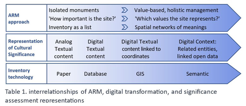
Cultural Significance Assessment of Archaeological Sites for Heritage Management: From Text of Spatial Networks of MeaningsHow Semantic Technologies and Spatial Networks Can Enhance Archaeological Resource ManagementRecommended by James Stuart Taylor based on reviews by Dominik Lukas and 1 anonymous reviewer
After a thorough review and consideration of the revised manuscript titled "Cultural Significance Assessment of Archaeological Sites for Heritage Management: From Text to Spatial Networks of Meanings" by Yael Alef and Yuval Shafriri [1], I am recommending the paper for publication. The authors have made significant strides in addressing the feedback from the initial review process, notably enhancing the manuscript's clarity, methodological detail, and overall contribution to the field of Archaeological Resource Management (ARM). On balance I think the paper competently navigates the shift from a traditional significance-focused assessment of isolated archaeological sites to a more holistic and interconnected approach, leveraging graph data models and spatial networks. This transition represents an advancement in the field, offering deeper insights into the sociocultural dynamics of archaeological sites. The case study of ancient synagogues in northern Israel, particularly the Huqoq Synagogue, serves as a compelling illustration of the potential of semantic technologies to enrich our understanding of cultural heritage. Significantly, the authors have responded to the call for a clearer methodological framework by providing a more detailed exposition of their use of knowledge graph visualization and semantic technologies. This response not only strengthens the paper's scientific rigor but also enhances its accessibility and applicability to a broader audience within the conservation and heritage management community. However, I do think it remains important to acknowledge areas where further work could enrich the paper's contribution. While the manuscript makes notable advancements in the technical and methodological domains, the exploration of the ethical and political implications of semantic technologies in ARM remains less developed. Recognizing the complex interplay of ethical and political considerations in archaeological assessments is crucial for the responsible advancement of the field. Thus, I suggest that future work could productively focus on these dimensions, offering a more comprehensive view of the implications of integrating semantic technologies into heritage management practices. I don't think that this omission is a reason to withold the paper for publication or seek further review. In fact I think it stands alone a paper quite well. Perhaps the authors might consider this as a complementary line of inquiry in their future work in the field. In conclusion then, I believe the revised manuscript represents a valuable addition to the literature, pushing boundaries of how we assess, understand, and manage archaeological resources. Its focus on semantic technologies and the creation of spatial networks of meanings marks a significant step forward in the field. I believe its publication will stimulate further research and discussion, particularly in the realms of ethical and political considerations, which remain ripe for exploration. Therefore, I'm happy to endorse the publication of this manuscript. Reference [1] Alef, Y and Shafriri, Y. (2024). Cultural Significance Assessment of Archaeological Sites for Heritage Management: From Text of Spatial Networks of Meanings. Zenodo, 8309992, ver. 5 peer-reviewed and recommended by Peer Community in Archaeology. https://doi.org/10.5281/zenodo.8309992 | Cultural Significance Assessment of Archaeological Sites for Heritage Management: From Text of Spatial Networks of Meanings | Yael Alef, Yuval Shafriri | <p>This study examines the shift towards a values-based approach for Archaeological Resource Management (ARM), emphasizing the integration of Context-Based Significance Assessment (CBSA) with semantic technologies into digital ARM inventories. We ... | | Computational archaeology, Conservation/Museum studies, Spatial analysis | James Stuart Taylor | 2023-09-01 22:24:15 | ||
10 Jan 2024
Linking Scars: Topology-based Scar Detection and Graph Modeling of Paleolithic Artifacts in 3DA valuable contribution to automated analysis of palaeolithic artefactsRecommended by Sebastian Hageneuer based on reviews by Lutz Schubert and 1 anonymous reviewer
In this paper (Linsel/Bullenkamp/Mara 2024), the authors propose an automatic system for scar-ridge-pattern detection on palaeolithic artefacts based on Morse Theory. Scare-Ridge pattern recognition is a process that is usually done manually while creating a drawing of the object itself. Automatic systems to detect scars or ridges exist, but only a small amount of them is utilizing 3D data. In addition to the scar-ridges detection, the authors also experiment in automatically detecting the operational sequence, the temporal relation between scars and ridges. As a result, they can export a traditional drawing as well as graph models displaying the relationships between the scars and ridges. After an introduction to the project and the practice of documenting palaeolithic artefacts, the authors explain their procedure in automatising the analysis of scars and ridges as well as their temporal relation to each other on these artefacts. To illustrate the process, an open dataset of lithic artefacts from the Grotta di Fumane, Italy, was used and 62 artefacts selected. To establish a Ground Truth, the artefacts were first annotated manually. The authors then continue to explain in detail each step of the automated process that follows and the results obtained. In the second part of the paper, the results are presented. First the results of the segmentation process shows that the average percentage of correctly labelled vertices is over 91%, which is a remarkable result. The graph modelling however shows some more difficulties, which the authors are aware of. To enhance the process, the authors rightfully aim to include datasets of experimental archaeology in the future. They also aim to develop a way of detecting the operational sequence automatically and precisely. This paper has great potential as it showcases exactly what Digital and Computational Archaeology is about: The development of new digital methods to enhance the analysis of archaeological data. While this procedure is still in development, the authors were able to present a valuable contribution to the automatization of analytical archaeology. By creating a step towards the machine-readability of this data, they also open up the way to further steps in machine learning within Archaeology. BibliographyLinsel, F., Bullenkamp, J. P., and Mara, H. (2024). Linking Scars: Topology-based Scar Detection and Graph Modeling of Paleolithic Artifacts in 3D, Zenodo, 8296269, ver. 3 peer-reviewed and recommended by Peer Community in Archaeology. https://doi.org/10.5281/zenodo.8296269 | Linking Scars: Topology-based Scar Detection and Graph Modeling of Paleolithic Artifacts in 3D | Florian Linsel, Jan Philipp Bullenkamp & Hubert Mara | <p>Motivated by the concept of combining the archaeological practice of creating lithic artifact drawings with the potential of 3D mesh data, our goal in this project is not only to analyze the shape at the artifact level, but also to enable a mor... | | Computational archaeology, Europe, Lithic technology, Upper Palaeolithic | Sebastian Hageneuer | 2023-09-01 23:03:59 | ||
08 Apr 2024
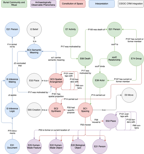
Spaces of funeral meaning. Modelling socio-spatial relations in burial contextsA new approach to a data ontology for the qualitative assessment of funerary spacesRecommended by Asuman Lätzer-Lasar based on reviews by 2 anonymous reviewers
The paper by Aline Deicke [1] is very readable, and it succeeds in presenting a still unnoticed topic in a well-structured way. It addresses the topic of “how to model social-spatial relations in antiquity”, as the title concisely implies, and makes important and interesting points about their interrelationship by drawing on latest theories of sociologists such as Martina Löw combined with digital tools, such as the CIDOC CRM-modeling. The author provides an introductory insight into the research history of funerary archaeology and addresses the problematic issue of not having investigated fully the placement of entities of the grave inventory. So far, the focus of the analysis has been on the composition of the assemblage and not on the positioning within this space-and time-limited context. However, the positioning of the various entities within the burial context also reveals information about the objects themselves, their value and function, as well as about the world view and intentions of the living and dead people involved in the burial. To obtain this form of qualitative data, the author suggests modeling knowledge networks using the CIDOC CRM. The method allows to integrate the spatial turn combined with aspects of the actor-network-theory. The theoretical backbone of the contribution is the fundamental scholarship of Martina Löw’s “Raumsoziologie” (sociology of space), especially two categories of action namely placing and spacing (SC1). The distinction between the two types of action enables an interpretative process that aims for the detection of meaningfulness behind the creation process (deposition process) and the establishment of spatial arrangement (find context). To illustrate with a case study, the author discusses elite burial sites from the Late Urnfield Period covering a region north of the Alps that stretches from the East of France to the entrance of the Carpathian Basin. With the integration of very basic spatial relations, such as “next to”, “above”, “under” and qualitative differentiations, for instance between iron and bronze knives, the author detects specific patterns of relations: bronze knives for food preparing (ritual activities at the burial site), iron knives associated with the body (personal accoutrement). The complexity of the knowledge engineering requires the gathering of several CIDOC CRM extensions, such as CRMgeo, CRMarchaeo, CRMba, CRMinf and finally CRMsoc, the author rightfully suggests. In the end, the author outlines a path that can be used to create this kind of data model as the basis for a graph database, which then enables a further analysis of relationships between the entities in a next step. Since this is only a preliminary outlook, no corrections or alterations are needed. The article is an important step in advancing digital archaeology for qualitative research. References [1] Deicke, A. (2024). Spaces of funeral meaning. Modelling socio-spatial relations in burial contexts. Zenodo, 8310170, ver. 4 peer-reviewed and recommended by Peer Community in Archaeology. https://doi.org/10.5281/zenodo.8310170 | Spaces of funeral meaning. Modelling socio-spatial relations in burial contexts | Aline Deicke | <p>Burials have long been one of the most important sources of archaeology, especially when studying past social practices and structure. Unlike archaeological finds from settlements, objects from graves can be assumed to have been placed there fo... | | Computational archaeology, Protohistory, Spatial analysis, Theoretical archaeology | Asuman Lätzer-Lasar | 2023-09-01 23:15:41 | ||
08 Jan 2024
Comparing summed probability distributions of shoreline and radiocarbon dates from the Mesolithic Skagerrak coast of NorwayTaking the Reverend Bayes to the seaside: Improving Norwegian Mesolithic shoreline dating with advanced statistical approachesRecommended by Felix Riede based on reviews by 2 anonymous reviewersThe paper entitled “Comparing summed probability distributions of shoreline and radiocarbon dates from the Mesolithic Skagerrak coast of Norway” by Isak Roalkvam and Steinar Solheim (2024) sheds new light on the degree to which shoreline dating may be used as a reliable chronological and palaeodemographic proxy in the Mesolthic of southern Norway. Based on geologically motivated investigations of eustatic and isostatic sea-level changes, shoreline dating has long been used as a method to date archaeological sites in Scandinavia, not least in Norway (e.g., Bjerck 2008; Astrup 2018). Establishing reliable sea-level curves requires much effort and variations across regions may be substantial. While this topic has seen a great deal of attention in Norway specifically, many purely geological questions remain. In addition, dating archaeological sites by linking their elevation to previously established seal-level curves relies strongly on the foundational assumption that such sites were in fact shore-bound. Given the strong contrast between terrestrial and marine productivity in high-latitude regions such as Norway, this assumption per se is not unreasonable. It is very likely that the sea has played a decisive role in the lives of Stone Age peoples throughout (Persson et al. 2017), just as it has in later periods here. However, many confounding factors relating to both taphonomy and human behaviour are also likely to have loosened the shore/site relationship. Systematic variations driven by cultural norms about settlement location, mobility, as well as factors such as shelter construction, fuel use and a range of other possible factors could variously have impacted the validity or at least the precision of shoreline dating. By developing a new methodology for handling and assessing a large number of shoreline dated sites, Roalkvam and Solheim use state-of-the-art Bayesian statistical methods to compare shoreline and radiocarbon dates as proxies for population activity. The probabilistic treatment of shoreline dates in this way is novel, and the divergences between the two data sets are interpreted by the authors in light of specific behavioural, cultural, and demographic changes. Many of the peaks and troughs observed in these time-series may be interpreted in light of long-observed cultural transitions while others may relate to population dynamics now also visible in palaeogenomic analyses (Günther et al. 2018; Manninen et al. 2021). Overall, this paper makes an innovative and fresh contribution to the use of shoreline dating in Norwegian archaeology, specifically by articulating it with recent developments in Open Science and data-driven approaches to archaeological questions (Marwick et al. 2017). References Astrup, P. M. 2018. Sea-Level Change in Mesolithic Southern Scandinavia : Long- and Short-Term Effects on Society and the Environment. Aarhus: Aarhus University Press. Bjerck, H. B. 2008. Norwegian Mesolithic Trends: A Review. In Mesolithic Europe, edited by Geoff Bailey and Penny Spikins, 60–106. Cambridge: Cambridge University Press. Günther, T., Malmström, H., Svensson, E. M., Omrak, A., Sánchez-Quinto, F., Kılınç, G. M., Krzewińska, M. et al. 2018. Population Genomics of Mesolithic Scandinavia: Investigating Early Postglacial Migration Routes and High-Latitude Adaptation. PLOS Biology 16 (1): e2003703. https://doi.org/10.1371/journal.pbio.2003703 Manninen, M. A., Damlien, H., Kleppe, J. I., Knutsson, K., Murashkin, A., Niemi, A. R., Rosenvinge, C. S. and Persson, P. 2021. First Encounters in the North: Cultural Diversity and Gene Flow in Early Mesolithic Scandinavia. Antiquity 95 (380): 310–28. https://doi.org/10.15184/aqy.2020.252 Marwick, B., d’Alpoim Guedes, J. A., Barton, C. M., Bates, L. A., Baxter, M., Bevan, A., Bollwerk, E. A. et al. 2017. Open Science in Archaeology. The SAA Archaeological Record 17 (4): 8–14. https://doi.org/10.31235/osf.io/72n8g Persson, P., Riede, F., Skar, B., Breivik, H. M. and Jonsson, L. 2017. The Ecology of Early Settlement in Northern Europe: Conditions for Subsistence and Survival. Sheffield: Equinox. Roalkvam, I. and Solheim, S. (2024). Comparing summed probability distributions of shoreline and radiocarbon dates from the Mesolithic Skagerrak coast of Norway, SocArXiv, 2f8ph, ver. 5 peer-reviewed and recommended by Peer Community in Archaeology. https://doi.org/10.31235/osf.io/2f8ph | Comparing summed probability distributions of shoreline and radiocarbon dates from the Mesolithic Skagerrak coast of Norway | Isak Roalkvam, Steinar Solheim | <p>By developing a new methodology for handling and assessing a large number of shoreline dated sites, this paper compares the summed probability distribution of radiocarbon dates and shoreline dates along the Skagerrak coast of south-eastern Norw... | | Computational archaeology, Dating, Europe, Mesolithic, Paleoenvironment | Felix Riede | 2023-09-26 16:43:29 | ||
26 Mar 2024
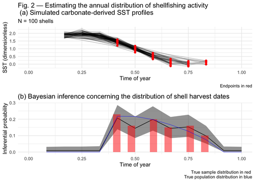
Inferring shellfishing seasonality from the isotopic composition of biogenic carbonate: A Bayesian approachMixture models and seasonal mobilityRecommended by Alfredo Cortell-Nicolau and Simon Carrignon based on reviews by Iza Romanowska and 1 anonymous reviewerThe paper by Brown & Lewis [1] presents an approach to measure seasonal mobility and subsistence practices. In order to do so, the paper proposes a Bayesian mixture model to estimate the annual distribution of shellfish harvesting activity. Following the recommendations of the two reviewers, the paper presents a clear and innovative method to assess seasonal mobility for prehistoric groups, although it could benefit from additional references regarding isotopic literature. While the adequacy of isotope analysis for estimating mobility patterns in Archaeology has been extensively proven by now, work on specific seasonal mobility is not that much abundant. However, this is a key issue, since seasonal mobility is one of the main social components defining the differences between groups both considering farming vs hunting and gathering or even among hunter-gatherer groups themselves. In this regard, the paper brings a valuable methodological resources that can be used for further research in this issue. One of its greatest values is the fact that it can quantify the uncertainty present in previous isotope studies in seasonal mobility. As stated by the authors, the model can still undergo several optimisation aspects, but as it stands, it is already providing a valuable asset regarding the quantification of uncertainy in the isotopic studies of seasonal mobility. Reference [1] Brown, J. and Lewis, G. (2024). Inferring shellfishing seasonality from the isotopic composition of biogenic carbonate: A Bayesian approach. Zenodo, 7949547, ver. 3 peer-reviewed and recommended by Peer Community in Archaeology. https://doi.org/10.5281/zenodo.7949547 | Inferring shellfishing seasonality from the isotopic composition of biogenic carbonate: A Bayesian approach | Jordan Brown and Gabriel Lewis | <p>The problem of accurately and reliably estimating the annual distribution of seasonally-varying human settlement and subsistence practices is a classic concern among archaeologists, which has only become more relevant with the increasing import... | | Archaeometry, Computational archaeology, Environmental archaeology, North America, Palaeontology, Paleoenvironment, Zooarchaeology | Alfredo Cortell-Nicolau | Iza Romanowska, Eduardo Herrera Malatesta, Alejandro Sierra Sainz-Aja, Sam Leggett, Christianne Fernee, Anonymous, Asier García-Escárzaga , Paul Szpak , Maria Elena Castiello , Jasmine Lundy , Tansy Branscombe | 2023-10-03 04:45:54 |


