Latest recommendations

| Id | Title * | Authors * | Abstract * ▼ | Picture * | Thematic fields * | Recommender | Reviewers | Submission date | |
|---|---|---|---|---|---|---|---|---|---|
06 Oct 2023
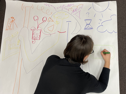
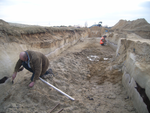
Body Mapping the Digital: Visually representing the impact of technology on archaeological practice.Understanding archaeological documentation through a participatory, arts-based approachRecommended by Nicolo Dell'Unto based on reviews by 2 anonymous reviewersThis paper presents the use of a participatory arts-based methodology to understand how digital and analogue tools affect individuals' participation in the process of archaeological recording and interpretation. The preliminary results of this work highlight the importance of rethinking archaeologists' relationship with different recording methods, emphasising the need to recognise the value of both approaches and to adopt a documentation strategy that exploits the strengths of both analogue and digital methods. Although a larger group of participants with broader and more varied experience would have provided a clearer picture of the impact of technology on current archaeological practice, the article makes an important contribution in highlighting the complex and not always easy transition that archaeologists trained in analogue methods are currently experiencing when using digital technology. This is assessed by using arts-based methodologies to enable archaeologists to consider how digital technologies are changing the relationship between mind, body and practice. I found the range of experiences described in the papers by the archaeologists involved in the experiment particularly interesting and very representative of the change in practice that we are all experiencing. As the article notes, the two approaches cannot be directly compared because they offer different possibilities: if analogue methods foster a deeper connection with the archaeological material, digital documentation seems to be perceived as more effective in terms of data capture, information exchange and data sharing (Araar et al., 2023). It seems to me that an important element to consider in such a study is the generational shift and the incredible divide between native and non-native digital. The critical issues highlighted in the paper are central and provide important directions for navigating this ongoing (digital) transition. References Araar, L., Morgan, C. and Fowler, L. (2023) Body Mapping the Digital: Visually representing the impact of technology on archaeological practice., Zenodo, 7990581, ver. 5 peer-reviewed and recommended by Peer Community in Archaeology. https://doi.org/10.5281/zenodo.7990581 | Body Mapping the Digital: Visually representing the impact of technology on archaeological practice. | Araar, Leila; Morgan, Colleen; Fowler, Louise | <p>This paper uses a participatory, art-based methodology to understand how digital and analog tools impact individuals' experience and perceptions of archaeological recording. Body mapping involves the co-creation of life-sized drawings and narra... | | Computational archaeology, Theoretical archaeology | Nicolo Dell'Unto | 2023-06-01 09:06:52 | ||
02 May 2024
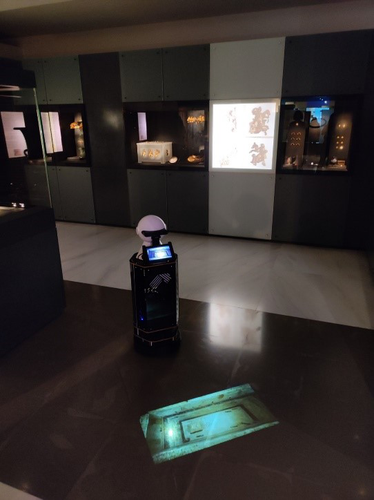
Exploiting RFID Technology and Robotics in the MuseumSocial Robotics in the Museum: a case for human-robot interaction using RFID TechnologyRecommended by Daniel Carvalho based on reviews by Dominik Hagmann, Sebastian Hageneuer and Alexis PantosThe paper “Exploiting RFID Technology and Robotics in the Museum” (Dimitriou et al 2023) is a relevant contribution to museology and an interface between the public, archaeological discourse and the field of social robotics. It deals well with these themes and is concise in its approach, with a strong visual component that helps the reader to understand what is at stake. The option of demonstrating the different steps that lead to the final construction of the robot is appropriate, so that it is understood that it really is a linked process and not simple tasks that have no connection. The use of RFID technology for topological movement of social robots has been continuously developed (e.g., Corrales and Salichs 2009; Turcu and Turcu 2012; Sequeira and Gameiro 2017) and shown to have advantages for these environments. Especially in the context of a museum, with all the necessary precautions to avoid breaching the public's privacy, RFID labels are a viable, low-cost solution, as the authors point out (Dimitriou et al 2023), and, above all, one that does not require the identification of users. It is in itself part of an ambitious project, since the robot performs several functions and not just one, a development compared to other currents within social robotics (see Hellou et al 2022: 1770 for a description of the tasks given to robots in museums). The robotic system itself also makes effective use of the localization system, both physically, by RFID labels and by knowing how to situate itself with the public visiting the museum, adapting to their needs, which is essential for it to be successful (see Gasteiger, Hellou and Ahn 2022: 690 for the theme of localization). Archaeology can provide a threshold of approaches when it comes to social robotics and this project demonstrates that, bringing together elements of interaction, education and mobility in a single method. Hence, this is a paper with great merit and deserves to be recommended as it allows us to think of the museum as a space where humans and non-humans can converge to create intelligible discourses, whether in the historical, archaeological or cultural spheres. References Dimitriou, A. G., Papadopoulou, S., Dermenoudi, M., Moneda, A., Drakaki, V., Malama, A., Filotheou, A., Raptopoulos Chatzistefanou, A., Tzitzis, A., Megalou, S., Siachalou, S., Bletsas, A., Yioultsis, T., Velentza, A. M., Pliasa, S., Fachantidis, N., Tsagkaraki, E., Karolidis, D., Tsoungaris, C., Balafa, P. and Koukouvou, A. (2024). Exploiting RFID Technology and Robotics in the Museum. Zenodo, 7805387, ver. 3 peer-reviewed and recommended by Peer Community in Archaeology. https://doi.org/10.5281/zenodo.7805387 Corrales, A. and Salichs, M.A. (2009). Integration of a RFID System in a Social Robot. In: Kim, JH., et al. Progress in Robotics. FIRA 2009. Communications in Computer and Information Science, vol 44. Springer, Berlin, Heidelberg. https://doi.org/10.1007/978-3-642-03986-7_8 Gasteiger, N., Hellou, M. and Ahn, H.S. (2023). Factors for Personalization and Localization to Optimize Human–Robot Interaction: A Literature Review. Int J of Soc Robotics 15, 689–701. https://doi.org/10.1007/s12369-021-00811-8 Hellou, M., Lim, J., Gasteiger, N., Jang, M. and Ahn, H. (2022). Technical Methods for Social Robots in Museum Settings: An Overview of the Literature. Int J of Soc Robotics 14, 1767–1786 (2022). https://doi.org/10.1007/s12369-022-00904-y Sequeira, J. S., and Gameiro, D. (2017). A Probabilistic Approach to RFID-Based Localization for Human-Robot Interaction in Social Robotics. Electronics, 6(2), 32. MDPI AG. http://dx.doi.org/10.3390/electronics6020032 Turcu, C. and Turcu, C. (2012). The Social Internet of Things and the RFID-based robots. In: IV International Congress on Ultra Modern Telecommunications and Control Systems, St. Petersburg, Russia, 2012, pp. 77-83. https://doi.org/10.1109/ICUMT.2012.6459769 | Exploiting RFID Technology and Robotics in the Museum | Antonis G. Dimitriou, Stella Papadopoulou, Maria Dermenoudi, Angeliki Moneda, Vasiliki Drakaki, Andreana Malama, Alexandros Filotheou, Aristidis Raptopoulos Chatzistefanou, Anastasios Tzitzis, Spyros Megalou, Stavroula Siachalou, Aggelos Bletsas, ... | <p>This paper summarizes the adoption of new technologies in the Archaeological Museum of Thessaloniki, Greece. RFID technology has been adopted. RFID tags have been attached to the artifacts. This allows for several interactions, including tracki... | | Conservation/Museum studies, Remote sensing | Daniel Carvalho | 2023-04-10 14:04:23 | ||
13 Jan 2024
Dealing with post-excavation data: the Omeka S TiMMA web-databaseManaging Archaeological Data with Omeka SRecommended by Jonathan Hanna based on reviews by Electra Tsaknaki and 1 anonymous reviewer based on reviews by Electra Tsaknaki and 1 anonymous reviewer
Managing data in archaeology is a perennial problem. As the adage goes, every day in the field equates to several days in the lab (and beyond). For better or worse, past archaeologists did all their organizing and synthesis manually, by hand, but since the 1970s ways of digitizing data for long term management and analysis have gained increasing attention [1]. It is debatable whether this ever actually made things easier, particularly given the associated problem of sustainable maintenance and accessibility of the data. Many older archaeologists, for instance, still have reels and tapes full of data that now require a new form of archaeology to excavate (see [2] for an unrealized idea on how to solve this). Today, the options for managing digital archaeological data are limited only by one’s imagination. There are systems built specifically for archaeology, such as Arches [3], Ark [4], Codifi [5], Heurist [6], InTerris Registries [7], OpenAtlas [8], S-Archeo [9], and Wild Note [10], as well as those geared towards museum collections like PastPerfect [11] and CatalogIt [12], among others. There are also mainstream databases that can be adapted to archaeological needs like MS Access [13] and Claris FileMaker [14], as well as various web database apps that function in much the same way (e.g., Caspio [15], dbBee [16], Amazon's Simpledb [17], Sci-Note [18], etc.) — all with their own limitations in size, price, and utility. One could also write the code for specific database needs using pre-built frameworks like those in Ruby-On-Rails [19] or similar languages. And of course, recent advances in machine-learning and AI will undoubtedly bring new solutions in the near future. But let’s be honest — most archaeologists probably just use Excel. That's partly because, given all the options, it is hard to decide the best tool and whether its worth changing from your current system, especially given few real-world examples in the literature. Bastien Rueff’s new paper [20] is therefore a welcomed presentation on the use of Omeka S [21] to manage data collected for the Timbers in Minoan and Mycenaean Architecture (TiMMA) project. Omeka S is an open-source web-database that is based in PHP and MySQL, and although it was built with the goal of connecting digital cultural heritage collections with other resources online, it has been rarely used in archaeology. Part of the issue is that Omeka Classic was built for use on individual sites, but this has now been scaled-up in Omeka S to accommodate a plurality of sites. Some of the strengths of Omeka S include its open-source availability (accessible regardless of budget), the way it links data stored elsewhere on the web (keeping the database itself lean), its ability to import data from common file types, and its multi-lingual support. The latter feature was particularly important to the TiMAA project because it allowed members of the team (ranging from English, Greek, French, and Italian, among others) to enter data into the system in whatever language they felt most comfortable. However, there are several limitations specific to Omeka S that will limit widespread adoption. Among these, Omeka S apparently lacks the ability to export metadata, auto-fill forms, produce summations or reports, or provide basic statistical analysis. Its internal search capabilities also appear extremely limited. And that is not to mention the barriers typical of any new software, such as onerous technical training, questionable long-term sustainability, or the need for the initial digitization and formatting of data. But given the rather restricted use-case for Omeka S, it appears that this is not a comprehensive tool but one merely for data entry and storage that requires complementary software to carry out common tasks. As such, Rueff has provided a review of a program that most archaeologists will likely not want or need. But if one was considering adopting Omeka S for a project, then this paper offers critical information for how to go about that. It is a thorough overview of the software package and offers an excellent example of its use in archaeological practice.
[1] Doran, J. E., and F. R. Hodson (1975) Mathematics and Computers in Archaeology. Harvard University Press. [2] Snow, Dean R., Mark Gahegan, C. Lee Giles, Kenneth G. Hirth, George R. Milner, Prasenjit Mitra, and James Z. Wang (2006) Cybertools and Archaeology. Science 311(5763):958–959. [3] https://www.archesproject.org/ [4] https://ark.lparchaeology.com/ [5] https://codifi.com/ [6] https://heuristnetwork.org/ [7] https://www.interrisreg.org/ [8] https://openatlas.eu/ [9] https://www.skinsoft-lab.com/software/archaelogy-collection-management [10] https://wildnoteapp.com/ [11] https://museumsoftware.com/ [12] https://www.catalogit.app/ [13] https://www.microsoft.com/en-us/microsoft-365/access [14] https://www.claris.com/filemaker/ [15] https://www.caspio.com/ [16] https://www.dbbee.com/ [17] https://aws.amazon.com/simpledb/ [18] https://www.scinote.net/ [19] https://rubyonrails.org/ [20] Rueff, Bastien (2023) Dealing with Post-Excavation Data: The Omeka S TiMMA Web-Database. peer-reviewed and recommended by Peer Community in Archaeology. https://zenodo.org/records/7989905 [21] https://omeka.org/
| Dealing with post-excavation data: the Omeka S TiMMA web-database | Bastien Rueff | <p>This paper reports on the creation and use of a web database designed as part of the TiMMA project with the Content Management System Omeka S. Rather than resulting in a technical manual, its goal is to analyze the relevance of using Omeka S in... | | Buildings archaeology, Computational archaeology | Jonathan Hanna | 2023-05-31 12:16:25 | ||
03 Feb 2024
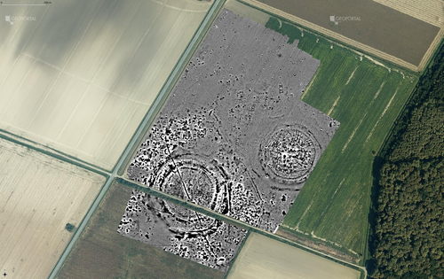
Digital surface models of crops used in archaeological feature detection – a case study of Late Neolithic site Tomašanci-Dubrava in Eastern CroatiaWhat lies on top lies also beneath? Connecting crop surface modelling to buried archaeology mapping.Recommended by Markos Katsianis based on reviews by Ian Moffat and Geert Verhoeven
This paper (Sosic et al. 2024) explores the Neolithic landscape of the Sopot culture in Đakovština, Eastern Slavonija, revealing a network of settlements through a multi-faceted approach that combines aerial archaeology, magnetometry, excavation, and field survey. This strategy facilitates scalable research tailored to the particularities of each site and allows for improved representations of buried archaeology with minimal intrusion. Using the site of Tomašanci-Dubrava as an example of the overall approach, the study further explores the use of drone imagery for 3D surface modeling, revealing a consistent correlation between crop surface elevation during full plant growth and ground terrain after ploughing, attributed to subsurface archaeological features. Results are correlated with magnetic survey and test-pitting data to validate the micro-topography and clarify the relationship between different subsurface structures. The results obtained are presented in a comprehensive way, including their source data, and are contextualized in relation to conventional cropmark detection approaches and expectations. I found this aspect very interesting, since the crop surface and terrain models contradict typical or textbook examples of cropmark detection, where the vegetation is projected to appear higher in ditches and lower in areas with buried archaeology (Renfrew & Bahn 2016, 82). Regardless, the findings suggest the potential for broader applications of crop surface or canopy height modelling in landscape wide surveys, utilizing ALS data or aerial photographs. It seems then that the authors make a valid argument for a layered approach in landscape-based site detection, where aerial imagery can be used to accurately map the topography of areas of interest, which can then be further examined at site scale using more demanding methods, such as geophysical survey and excavation. This scalability enhances the research's relevance in broader archaeological and geographical contexts and renders it a useful example in site detection and landscape-scale mapping. References Renfrew, C. and Bahn, P. (2016). Archaeology: theories, methods and practice. Thames and Hudson. Sosic Klindzic, R., Vuković, M., Kalafatić, H. and Šiljeg, B. (2024). Digital surface models of crops used in archaeological feature detection – a case study of Late Neolithic site Tomašanci-Dubrava in Eastern Croatia, Zenodo, 7970703, ver. 4 peer-reviewed and recommended by Peer Community in Archaeology. https://doi.org/10.5281/zenodo.7970703 | Digital surface models of crops used in archaeological feature detection – a case study of Late Neolithic site Tomašanci-Dubrava in Eastern Croatia | Sosic Klindzic Rajna; Vuković Miroslav; Kalafatić Hrvoje; Šiljeg Bartul | <p>This paper presents the results of a study on the neolithic landscape of the Sopot culture in the area of Đakovština in Eastern Slavonija. A vast network of settlements was uncovered using aerial archaeology, which was further confirmed and chr... | | Landscape archaeology, Neolithic, Remote sensing, Spatial analysis | Markos Katsianis | 2023-09-01 12:57:04 | ||
02 Jan 2024
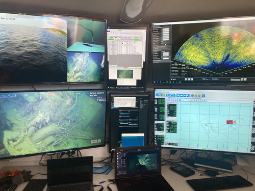
Advancing data quality of marine archaeological documentation using underwater robotics: from simulation environments to real-world scenariosBeyond Deep Blue: Underwater robotics, simulations and archaeologyRecommended by Daniel Carvalho based on reviews by Marco Moderato and 1 anonymous reviewerDiamanti et al. (2024) is a significant contribution to the field of underwater robotics and their use in archaeology, with an innovative approach to some major problems in the deployment of said technologies. It identifies issues when it comes to approaching Underwater Cultural Heritage (UCH) sites and does so through an interest in the combination of data, maneuverability, and the interpretation provided by the instruments that archaeologists operate. The article's motives are clear: it is not enough to find the means to reach these sites, but rather is fundamental to take a step forward in methodology and how we can safeguard certain aspects of data recovery with robust mission planning. To this end, the article does not fail to highlight previous contributions, in an intertwined web of references that demonstrate the marked evolution of the use of Unmanned Underwater Vehicles (UUVs), Remote Operated Vehicles (ROVs), Autonomous Underwater Vehicles (AUVs) and Autonomous Surface Vehicles (ASVs), which are growing exponentially in use (see Kapetanović et al. 2020). It should be emphasized that the notion of ‘aquatic environment’ used here is quite broad and is not limited to oceanic or maritime environments, which allows for a larger perspective on distinct technologies that proliferate in underwater archaeology. There is also a relevant discussion on the typologies of sensors and how these autonomous vehicles obtain their data, where are debated Inertial Measurement Units (IMU) and LiDAR systems. Thus, the authors of this article propose the creation of a model that acquires data through simulations, which allows for a better understanding of what a real mission presupposes in the field. Their tripartite method - pre-mission planning; mission plan and post-mission plan - offers a performing algorithm that simplifies and provides reliability to all the parts of the intervention. The use of real cases to create simulation models allows for a substantial approximation to common practice in underwater environments. And yet, the article is at its most innovative status when it combines all the elements it sets out to explore. It could simply focus on the methodological or planning component, on obtaining data, or on theoretical problems. But it goes further, which makes this approach more complete and of interest to the archaeological community. By not taking any part as isolated, the problems and possible solutions arising from the course of the mission are carried over from one parameter to another, where details are worked upon and efficiency goals are set. One of the most significant cases is the tuning of ocean optics in aquatic environments according to the idiosyncracies of real cases (Diamanti et al. 2024: 8), a complex endeavor but absolutely necessary in order to increase the informative potential of the simulation. The exploration of various data capture models is also welcome, for the purposes of comparison and adaptation on a case-by-case basis. The brief theoretical reflection offered at the end of the article dwells in all these points and problematizes the difference between terrestrial and aquatic archaeology. In fact, the distinction does not only exist in the technical component, as although it draws in theoretical elements from archaeology that is carried out on land (see Krieger 2012 for this matter), the problems and interpretations are shaped by different factors and therefore become unique (Diamanti et al 2024: 15). The future, according to the authors, lies in increasing the autonomy of these vehicles so that the human element does not have to make decisions in a systematic way. It is in that note, and in order for that path to become closer to reality, that we strongly recommend this article for publication, in conjunction with the comments of the reviewers. We hope that its integrated approach, which brings together methods, theories and reflections, can become a broader modus operandi within the field of underwater robotics applied to archaeology. References: Diamanti, E., Yip, M., Stahl, A. and Ødegård, Ø. (2024). Advancing data quality of marine archaeological documentation using underwater robotics: from simulation environments to real-world scenarios, Zenodo, 8305098, ver. 4 peer-reviewed and recommended by Peer Community in Archaeology. https://doi.org/10.5281/zenodo.8305098 Kapetanović, N., Vasilijević, A., Nađ, Đ., Zubčić, K., and Mišković, N. (2020). Marine Robots Mapping the Present and the Past: Unraveling the Secrets of the Deep. Remote Sensing, 12(23), 3902. MDPI AG. http://dx.doi.org/10.3390/rs12233902 Krieger, W. H. (2012). Theory, Locality, and Methodology in Archaeology: Just Add Water? HOPOS: The Journal of the International Society for the History of Philosophy of Science, 2(2), 243–257. https://doi.org/10.1086/666956
| Advancing data quality of marine archaeological documentation using underwater robotics: from simulation environments to real-world scenarios | Diamanti, Eleni; Yip, Mauhing; Stahl, Annette; Ødegård, Øyvind | <p>This paper presents a novel method for visual-based 3D mapping of underwater cultural heritage sites through marine robotic operations. The proposed methodology addresses the three main stages of an underwater robotic mission, specifically the ... | | Computational archaeology, Remote sensing | Daniel Carvalho | 2023-08-31 16:03:10 | ||
05 Jan 2024
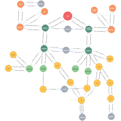
Transforming the CIDOC-CRM model into a megalithic monument property graphInformative description of a project implementing a CIDOC-CRM based native graph database for representing megalithic informationRecommended by Isto Huvila based on reviews by 2 anonymous reviewersThe paper “Transforming the CIDOC-CRM model into a megalithic monument property graph” describes an interesting endeavour of developing and implementing a CIDOC-CRM based knowledge graph using a native graph database (Neo4J) to represent megalithic information (Câmara et al. 2023). While there are earlier examples of using native graph databases and CIDOC-CRM in diverse heritage contexts, the present paper is useful addition to the literature as a detailed description of an implementation in the context of megalithic heritage. The paper provides a demonstration of a working implementation, and guidance for future projects. The described project is also documented to an extent that the paper will open up interesting opportunities to compare the approach to previous and forthcoming implementations. The same applies to the knowledge graph and use of CIDOC-CRM in the project. Readers interested in comparing available technologies and those who are developing their own knowledge graphs might have benefited of a more detailed description of the work in relation to the current state-of-the-art and what the use of a native graph database in the built-heritage contexts implies in practice for heritage documentation beyond that it is possible and it has potentially meaningful performance-related advantages. While also the reasons to rely on using plain CIDOC-CRM instead of extensions could have been discussed in more detail, the approach demonstrates how the plain CIDOC-CRM provides a good starting point to satisfy many heritage documentation needs. As a whole, the shortcomings relating to positioning the work to the state-of-the-art and reflecting and discussing design choices do not reduce the value of the paper as a valuable case description for those interested in the use of native graph databases and CIDOC-CRM in heritage documentation in general and the documentation of megalithic heritage in particular. ReferencesCâmara, A., de Almeida, A. and Oliveira, J. (2023). Transforming the CIDOC-CRM model into a megalithic monument property graph, Zenodo, 7981230, ver. 4 peer-reviewed and recommended by Peer Community in Archaeology. https://doi.org/10.5281/zenodo.7981230 | Transforming the CIDOC-CRM model into a megalithic monument property graph | Ariele Câmara, Ana de Almeida, João Oliveira | <p>This paper presents a method to store information about megalithic monuments' building components as graph nodes in a knowledge graph (KG). As a case study we analyse the dolmens from the region of Pavia (Portugal). To build the KG, information... | | Computational archaeology | Isto Huvila | 2023-05-29 13:46:49 | ||
02 Dec 2023
Research perspectives and their influence for typologiesComplexity and Purpose – A Pragmatic Approach to the Diversity of Archaeological Classificatory Practice and TypologyRecommended by Shumon Tobias Hussain, Felix Riede and Sébastien Plutniak based on reviews by Ulrich Veit, Martin Hinz, Artur Ribeiro and 1 anonymous reviewer
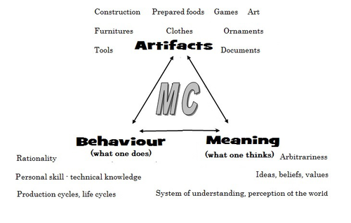
“Research perspectives and their influence for typologies” by E. Giannichedda (1) is a contribution to the upcoming volume on the role of typology and type-thinking in current archaeological theory and praxis edited by the recommenders. Taking a decidedly Italian perspective on classificatory practice grounded in what the author dubs the “history of material culture”, Giannichedda offers an inventory of six divergent but overall complementary modes of ordering archaeological material: i) chrono-typological and culture-historical, ii) techno-anthropological, iii) social, iv) socio-economic and v) cognitive. These various lenses broadly align with similarly labeled perspectives on the archaeological record more generally. According to the author, they lend themselves to different ways of identifying and using types in archaeological work. Importantly, Giannichedda reminds us that no ordering practice is a neutral act and typologies should not be devised for their own sake but because we have specific epistemic interests. Even though this view is certainly not shared by everyone involved in the broader debate on the purpose and goal of systematics, classification, typology or archaeological taxonomy (2–4), the paper emphatically defends the long-standing idea that ordering practices are not suitable to elucidate the structure and composition of reality but instead devise tools to answer certain questions or help investigate certain dimensions of complex past realities. This position considers typologies as conceptual prosthetics of knowing, a view that broadly resonates with what is referred to as epistemic instrumentalism in the philosophy of science (5, 6). Types and type-work should accordingly reflect well-defined means-end relationships. Based on the recognition of archaeology as part of an integrated “history of material culture” rooted in a blend of continental and Anglophone theories, Giannichedda argues that type-work should pay attention to relevant relations between various artefacts in a given historical context that help further historical understanding. Classificatory practice in archaeology – the ordering of artefactual materials according to properties – must thus proceed with the goal of multifaceted “historical reconstruction in mind”. It should serve this reconstruction, and not the other way around. By drawing on the example of a Medieval nunnery in the Piedmont region of northwestern Italy, Giannichedda explores how different goals of classification and typo-praxis (linked to i-v; see above) foreground different aspects, features, and relations of archaeological materials and as such allow to pinpoint and examine different constellations of archaeological objects. He argues that archaeological typo-praxis, for this reason, should almost never concern itself with isolated artefacts but should take into account broader historical assemblages of artefacts. This does not necessarily mean to pay equal attention to all available artefacts and materials, however. To the contrary, in many cases, it is necessary to recognize that some artefacts and some features are more important than others as anchors grouping materials and establishing relations with other objects. An example are so-called ‘barometer objects’ (7) or unique pieces which often have exceptional informational value but can easily be overlooked when only shared features are taken into consideration. As Giannichedda reminds us, considering all objects and properties equally is also a normative decision and does not render ordering less subjective. The archaeological analysis of types should therefore always be complemented by an examination of variants, even if some of these variants are idiosyncratic or even unique. A type, then, may be difficult to define universally. In total, “Research perspectives and their influence for typologies” emphasizes the need for “elastic” and “flexible” approaches to archaeological types and typologies in order to effectively respond to the manifold research interests cultivated by archaeologists as well as the many and complex past realities they face. Complexity is taken here to indicate that no single research perspective and associated mode of ordering can adequately capture the dimensionality and richness of these past realities and we can therefore only benefit from multiple co-existing ways of grouping and relating archaeological artefacts. Different logics of grouping may simply reveal different aspects of these realities. As such, Giannichedda’s proposal can be read as a formulation of the now classic pluralism thesis (8–11) – that only a plurality of ways of ordering and interrelating artefacts can unlock the full suite of relationships within historical assemblages archaeologists are interested in.
Bibliography 1. Giannichedda, E. (2023). Research perspectives and their influence for typologies, Zenodo, 7322855, ver. 9 peer-reviewed and recommended by Peer Community in Archaeology. https://doi.org/10.5281/zenodo.7322855 2. Dunnell, R. C. (2002). Systematics in Prehistory, Illustrated Edition (The Blackburn Press, 2002). 3. Reynolds, N. and Riede, F. (2019). House of cards: cultural taxonomy and the study of the European Upper Palaeolithic. Antiquity 93, 1350–1358. https://doi.org/10.15184/aqy.2019.49 4. Lyman, R. L. (2021). On the Importance of Systematics to Archaeological Research: the Covariation of Typological Diversity and Morphological Disparity. J Paleo Arch 4, 3. https://doi.org/10.1007/s41982-021-00077-6 5. Van Fraassen, B. C. (2002). The empirical stance (Yale University Press). 6. Stanford, P. K. (2006). Exceeding Our Grasp: Science, History, and the Problem of Unconceived Alternatives (Oxford University Press). https://doi.org/10.1093/0195174089.001.0001 7. Radohs, L. (2023). Urban elite culture: a methodological study of aristocracy and civic elites in sea-trading towns of the southwestern Baltic (12th-14th c.) (Böhlau). 8. Kellert, S. H., Longino, H. E. and Waters, C. K. (2006). Scientific pluralism (University of Minnesota Press). 9. Cat, J. (2012). Essay Review: Scientific Pluralism. Philosophy of Science 79, 317–325. https://doi.org/10.1086/664747 10. Chang, H. (2012). Is Water H2O?: Evidence, Realism and Pluralism (Springer Netherlands). https://doi.org/10.1007/978-94-007-3932-1 11. Wylie, A. (2015). “A plurality of pluralisms: Collaborative practice in archaeology” in Objectivity in Science, (Springer), pp. 189–210. https://doi.org/10.1007/978-3-319-14349-1_10
| Research perspectives and their influence for typologies | Enrico Giannichedda | <p>This contribution opens with a brief reflection on theoretical archaeology and practical material classification activities. Following this, the various questions that can be asked of artefacts to be classified will be briefly addressed. Questi... | | Theoretical archaeology | Shumon Tobias Hussain | 2022-11-10 20:14:52 | ||
01 Dec 2021
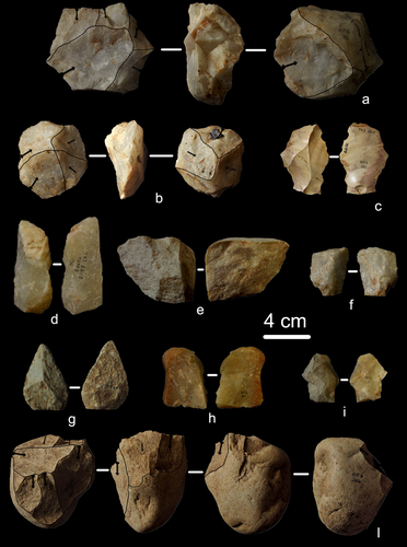
A closer look at an eroded dune landscape: first functional insights into the Federmessergruppen site of Lommel-MaatheidePotential of a large-scale functional analysis to reconstructing past human activities at the Final Palaeolithic site of Lommel-MaatheideRecommended by Marta Arzarello and Alice Leplongeon based on reviews by Gabriele Luigi Francesco Berruti and Ana Abrunhosa
The paper “A closer look at an eroded dune landscape: first functional insights into the Federmessergruppen site of Lommel-Maatheide” [1] focuses on the final Palaeolithic (Federmesser) site of Lommel-Maatheide. Federmesser sites from northern Belgium such as Lommel-Maatheide, Meer and Rekem, show evidence for dense human occupation of specific areas located on top of Tardiglacial dunes nearby water bodies [2]. Preserved spatial distribution of finds at the sites suggest different activity areas and the presence of habitat structures [2]. However, because of the low organic preservation at the sites, functional analyses of lithic assemblages have the potential to significantly contribute to the spatial organisation of activities at these sites. This study by Tomasso et al. [1], represents an excellent example of a large-scale integrated approach to the study of lithic industries. The article undoubtedly demonstrates the potential of the proposed methodology and the reliability of the results obtained. The article explores two different aspects (linked and excellently interconnected here): the possibility to apply use wear, residue and fracture analyses, on lithic assemblages affected by taphonomical alterations and to study lithic assemblages from dune landscapes. The study allows to answer differentiated questions: what is the influence of taphonomical alterations on use wear analysis? How do excavation methods impact the formation of use wear and the preservation of residues? Can we recognize distinct domestic activities? The article also provides an interesting hypothesis about hunting activities and propulsion methods. The applied methodology is effectively interdisciplinary and innovative. It demonstrates how a truly integrated and articulated approach can represent the turning point for going beyond a mainly descriptive dimension to move towards a real understanding of the sites. Studies dedicated to the analysis of the propulsion mode are not very frequent, but they are surely very important to better understand human behaviour [3]. Here, the methodology developed for the evaluation of the propulsion mode represent an important starting point for the definition of a new approach. Morphological and morphometrical analysis are integrated to the evaluation of the mechanical stress, to fracture delineations and to the hafting system (the latter defined on experimental basis). This article therefore underlines the potential of combining different approaches to functional analysis associated with a ‘tailored’ reference collection and applying them to a high number of artefacts for reconstructing past human activities involving materials that are otherwise not preserved in these contexts. [1] Tomasso, S., Cnuts, D., Coppe, J., Geerts, F., Gils, M.V., Bie, M.D., Rots, V. (2021). A closer look at an eroded dune landscape: first functional insights into the Federmessergruppen site of Lommel-Maatheide. https://doi.org/10.31219/osf.io/pf3sm, ver 3 peer-reviewed and recommended by PCI Archaeology. [2] De Bie, M., Van Gils, M. (2006). Les habitats des groupes à Federmesser (aziliens) dans le Nord de la Belgique. Bulletin de la Société préhistorique française, 103, 781–790. [3] Coppe, J., Lepers, C., Clarenne, V., Delaunois, E., Pirlot, M. and Rots V. (2019). Ballistic Study Tackles Kinetic Energy Values of Palaeolithic Weaponry. Archaeometry, (61)4, 933-956. https://doi.org/10.1111/arcm.12452 | A closer look at an eroded dune landscape: first functional insights into the Federmessergruppen site of Lommel-Maatheide | Sonja Tomasso, Dries Cnuts, Justin Coppe, Marijn Van Gils, Ferdi Geerts, Marc De Bie, Veerle Rots | <p>The vast Federmessergruppen site of Lommel-Maatheide, which is located in the Campine region (Northern Belgium), revealed the presence of numerous Final Palaeolithic concentrations situated on a large Late Glacial sand ridge on the northern edg... | | Environmental archaeology, Landscape archaeology, Lithic technology, Traceology, Upper Palaeolithic | Marta Arzarello | 2021-09-14 17:04:38 | ||
02 May 2024
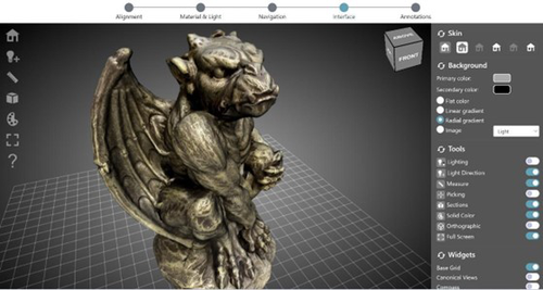
ARIADNEplus Visual Media Service 3D configurator: toward full guided publication of high-resolution 3D dataARIADNEplus Visual Media Service 3D configurator: a new tool for the visual organisation of 3D datasetsRecommended by Ian Moffat based on reviews by Sebastian Hageneuer, Vayia Panagiotidis, Erik Champion and Martina Trognitz
The manuscript "ARIADNEplus Visual Media Service 3D configurator: toward full guided publication of high-resolution 3D data" by Potenziani et al. [1] provides an excellent introduction to the Visual Media Service 3D Configurator. This is an exciting tool, focused on cultural heritage, that forms part of the Visual Media Service, a web-based platform for uploading a range of complex data sets, including high-resolution images, Reflectance Transformation Imaging images and 3D models and transforming them into an appropriate format for interation and visualisation on the web. The 3D Configurator Tool provides researchers with a wizard which assist with the presentation of 3D models. This manuscript provides a history and context for the development of the Visual Media Service and previous related tools such as 3DHOP, Nexus and Relight/OpenLIME. It also provides detailed information about the functionality of the 3D Configurator, including the Alignment, Material & Light, Navigation, Interface and Annotation steps. The Discussion section provides information about applications and users of the Visual Media Service, current limitations and planned future developments. Reviewers Hageneuer, Champion, Trognitz and Panagiotidis all provided important suggestions to the authors which have improved the clarity and scope of this manuscript. While this manscript does not present a case study using this tool, I recommend it to readers as a detailed and clear introduction to the Visual Media Service 3D configurator which may inspire them to use this for their own research. [1] Potenziani, M., Ponchio, F., Callieri, M., and Cignoni, P. (2024). ARIADNEplus Visual Media Service 3D configurator: toward full guided publication of high-resolution 3D data. Zenodo, 8075050, ver. 5 peer-reviewed and recommended by Peer Community in Archaeology. https://doi.org/10.5281/zenodo.10894515 | ARIADNEplus Visual Media Service 3D configurator: toward full guided publication of high-resolution 3D data | Potenziani, Marco; Ponchio, Federico; Callieri, Marco; Cignoni, Paolo | <p>The use of digital visual media in everyday work is nowadays a common practice in many different domains, including Cultural Heritage (CH). Because of that, the presence of digital datasets in CH archives and repositories is becoming more and m... | | Computational archaeology | Ian Moffat | 2023-06-23 17:37:47 | ||
12 Feb 2024
First evidence of a Palaeolithic occupation of the Po plain in Piedmont: the case of Trino (north-western Italy)Not Simply the Surface: Manifesting Meaning in What Lies Above.Recommended by Marcel Kornfeld based on reviews by Lawrence Todd, Jason LaBelle and 2 anonymous reviewersThe archaeological record comes in many forms. Some, such as buried sites from volcanic eruptions or other abrupt sedimentary phenomena are perhaps the only ones that leave relatively clean snapshots of moments in the past. And even in those cases time is compressed. Much, if not all other archaeological record is a messy affair. Things, whatever those things may be, artifacts or construction works (i.e., features), moved, modified, destroyed, warped and in a myriad of ways modified from their behavioral contexts. Do we at some point say the record is worthless? Not worth the effort or continuing investigation. Perhaps sometimes this may be justified, but as Daffara and colleagues show, heavily impacted archaeological remains can give us clues and important information about the past. Thoughtful and careful prehistorians can make significant contributions from what appear to be poor archaeological records. In the case of Daffara and colleagues, a number of important theoretical cross-sections can be recognized. For a long time surface archaeology was thought of simply as a way of getting a preliminary peak at the subsurface. From some of the earliest professional archaeologists (e.g., Kidder 1924, 1931; Nelson 1916) to the New Archaeologists of the 1960s, the link between the surface and subsurface was only improved in precision and systematization (Binford et al. 1970). However, at Hatchery West Binford and colleagues not only showed that surface material can be used more reliably to get at the subsurface, but that substantive behavioral inferences can be made with the archaeological record visible on the surface. Much more important are the behavioral implications drawn from surface material. I am not sure we can cite the first attempts at interpreting prehistory from the surface manifestations of the archaeological record, but a flurry of such approaches proliferated in the 1970s and beyond (Dunnell and Dancey 1983; Ebert 1992; Foley 1981). Off-site archaeology, non-site archaeology, later morphing into landscape archaeology all deal strictly with surface archaeological record to aid in understanding the past. With the current paper, Daffara and colleagues (2024) are clearly in this camp. Although still not widely accepted, it is clear that some behaviors (parts of systems) can only be approached from surface archaeological record. It is very unlikely that a future archaeologist will be able to excavate an entire human social/cultural system; people moving from season to season, creating multiple long and short term camps, travelling, procuring resources, etc. To excavate an entire system one would need to excavate 20,000 km2 or some similarly impossible task. Even if it was physically possible to excavate such an enormous area, it is very likely that some of contextual elements of any such system will be surface manifestations. Without belaboring the point, surface archaeological record yields data like any other archaeological record. We must contextual the archaeological artifacts or features weather they come from surface or below. Daffara and colleagues show us that we can learn about deep prehistory of northern Italy, with collections that were unsystematically collected, biased by agricultural as well as other land deformations agents. They carefully describe the regional prehistory as we know it, in particular specific well documented sites and assemblages as a means of applying such knowledge to less well controlled or uncontrolled collections.
References Binford, L., Binford, R. S. R., Whallon, R. and Hardin, M. A. (1970). Archaeology of Hatchery West. Memoirs of the Society for American Archaeology, No. 24, Washington D.C. Daffara, S., Giraudi, C., Berruti, G. L. F., Caracausi, S. and Garanzini, F. (2024). First evidence of a Palaeolithic frequentation of the Po plain in Piedmont: the case of Trino (north-western Italy), OSF Preprints, pz4uf, ver. 6 peer-reviewed and recommended by Peer Community in Archaeology. https://doi.org/10.31219/osf.io/pz4uf Dunnell, R. C. and Dancey, W. S. (1983). The siteless survey: a regional scale data collection strategy. In Advances in Archaeological Method and Theory, vol. 6, edited by Michael B. Schiffer, pp. 267-287. Academic Press, New York. Ebert, J. I. (1992). Distributional Archaeology. University of New Mexico Press, Albuquerque. Foley, R. A. (1981). Off site archaeology and human adaptation in eastern Africa: An analysis of regional artefact density in the Amboseli, Southern Kenya. British Archaeological Reports International Series 97. Cambridge Monographs in African Archaeology 3. Oxford England. Kidder, A. V. (1924). An Introduction to the Study of Southwestern Archaeology, With a Preliminary Account of the Excavations at Pecos. Papers of the Southwestern Expedition, Phillips Academy, no. 1. New Haven, Connecticut. Kidder, A. V. (1931). The Pottery of Pecos, vol. 1. Papers of the Southwestern Expedition, Phillips Academy. New Haven, Connecticut. Nelson, N. (1916). Chronology of the Tano Ruins, New Mexico. American Anthropologist 18(2):159-180. | First evidence of a Palaeolithic occupation of the Po plain in Piedmont: the case of Trino (north-western Italy) | Sara Daffara, Carlo Giraudi, Gabriele L.F. Berruti, Sandro Caracausi, Francesca Garanzini | <p>The Trino hill is an isolated relief located in north-western Italy, close to Trino municipality. The hill was subject of multidisciplinary studies during the 1970s, when, because of quarrying and agricultural activities, five concentrations of... | | Lithic technology, Middle Palaeolithic | Marcel Kornfeld | 2023-10-04 16:58:19 |


