Latest recommendations

| Id | Title * | Authors * ▲ | Abstract * | Picture * | Thematic fields * | Recommender | Reviewers | Submission date | |
|---|---|---|---|---|---|---|---|---|---|
02 May 2024
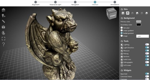
ARIADNEplus Visual Media Service 3D configurator: toward full guided publication of high-resolution 3D dataARIADNEplus Visual Media Service 3D configurator: a new tool for the visual organisation of 3D datasetsRecommended by Ian Moffat based on reviews by Sebastian Hageneuer, Vayia Panagiotidis, Erik Champion and Martina Trognitz based on reviews by Sebastian Hageneuer, Vayia Panagiotidis, Erik Champion and Martina Trognitz
The manuscript "ARIADNEplus Visual Media Service 3D configurator: toward full guided publication of high-resolution 3D data" by Potenziani et al. [1] provides an excellent introduction to the Visual Media Service 3D Configurator. This is an exciting tool, focused on cultural heritage, that forms part of the Visual Media Service, a web-based platform for uploading a range of complex data sets, including high-resolution images, Reflectance Transformation Imaging images and 3D models and transforming them into an appropriate format for interation and visualisation on the web. The 3D Configurator Tool provides researchers with a wizard which assist with the presentation of 3D models. This manuscript provides a history and context for the development of the Visual Media Service and previous related tools such as 3DHOP, Nexus and Relight/OpenLIME. It also provides detailed information about the functionality of the 3D Configurator, including the Alignment, Material & Light, Navigation, Interface and Annotation steps. The Discussion section provides information about applications and users of the Visual Media Service, current limitations and planned future developments. Reviewers Hageneuer, Champion, Trognitz and Panagiotidis all provided important suggestions to the authors which have improved the clarity and scope of this manuscript. While this manscript does not present a case study using this tool, I recommend it to readers as a detailed and clear introduction to the Visual Media Service 3D configurator which may inspire them to use this for their own research. [1] Potenziani, M., Ponchio, F., Callieri, M., and Cignoni, P. (2024). ARIADNEplus Visual Media Service 3D configurator: toward full guided publication of high-resolution 3D data. Zenodo, 8075050, ver. 5 peer-reviewed and recommended by Peer Community in Archaeology. https://doi.org/10.5281/zenodo.10894515 | ARIADNEplus Visual Media Service 3D configurator: toward full guided publication of high-resolution 3D data | Potenziani, Marco; Ponchio, Federico; Callieri, Marco; Cignoni, Paolo | <p>The use of digital visual media in everyday work is nowadays a common practice in many different domains, including Cultural Heritage (CH). Because of that, the presence of digital datasets in CH archives and repositories is becoming more and m... | | Computational archaeology | Ian Moffat | 2023-06-23 17:37:47 | ||
16 May 2024
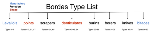
A return to function as the basis of lithic classificationUsing insights from psychology and primatology to reconsider function in lithic typologiesRecommended by Sébastien Plutniak, Felix Riede and Shumon Tobias Hussain based on reviews by Vincent Delvigne and 1 anonymous reviewer
The paper “A return to function as the basis of lithic classification” by Radu Iovita (2024) is a contribution to an upcoming volume on the role of typology and type-thinking in current archaeological theory and praxis edited by the PCI recommenders. In this context, the paper offers an in-depth discussion of several crucial dimensions of typological thinking in past and current lithic studies, namely:
Discussing and importantly re-articulating these concepts, Iovita ultimately aims at “establishing unified guiding principles for studying a technology that spans several million years and several different species whose brain capacities range from ca. 300–1400 cm³”. The notion that tool function should dictate classification is not new (e.g. Gebauer 1987). It is particularly noteworthy, however, that the paper engages carefully with various relevant contributions on the topic from non-Anglophone research traditions. First, its considering works on lithic typologies published in other languages, such as Russian (Sergei Semenov), French (Georges Laplace), and German (Joachim Hahn). Second, it takes up the ideas of two French techno-anthropologists, in particular:
Interestingly, Iovita grounds his argumentation on insights from primatology, psychology and the cognitive sciences, to the extent that they fuel discussion on archaeological concepts and methods. Results regarding the so-called “design stance” for example play a crucial role: coined by philosopher and cognitive scientist and philosopher Daniel Dennett (1942-2024), this notion encompasses the possible discrepancies between the designer’s intended purpose and the object's current functions. DIF, as discussed by Iovita, directly relates to this idea, illustrating how concepts from other sciences can fruitfully be injected into archaeological thinking. Lastly, readers should note the intellectual contents generated on PCI as part of the reviewing process of the paper itself: both the reviewers and the author have engaged in in-depth discussions on the idea of (tool) “function” and its contested relationship with form or typology, delineating and mapping different views on these key issues in lithic study which are worth reading on their own. ReferencesGebauer, A. B. (1987). Stylistic Analysis. A Critical Review of Concepts, Models, and Interpretations, Journal of Danish Archaeology, 6, p. 223–229. Geertz, C. (1975). Common Sense as a Cultural System, The Antioch Review, 33 (1), p. 5–26. Iovita, R. (2024). A return to function as the basis of lithic classification. Zenodo, 7734147, ver. 5 peer-reviewed and recommended by Peer Community in Archaeology. https://doi.org/10.5281/zenodo.7734147 Lévi-Strauss, C. (1962). La pensée sauvage. Paris: Plon. Lévi-Strauss, C. (2021). Wild Thought: A New Translation of “La Pensée sauvage”. Translated by Jeffrey Mehlman & John Leavitt. Chicago, Illinois: University of Chicago Press. Sigaut, F. (1991). “Un couteau ne sert pas à couper, mais en coupant. Structure, fonctionnement et fonction dans l'analyse des objets” in 25 Ans d'études technologiques en préhistoire : Bilan et perspectives, Juan-les-Pins: Éditions de l'association pour la promotion et la diffusion des connaissances archéologiques, p. 21-34. | A return to function as the basis of lithic classification | Radu Iovita | <p>Complex tool use is one of the defining characteristics of our species, and, because of the good preservation of stone tools (lithics), one of the few which can be studied on the evolutionary time scale. However, a quick look at the lithics lit... | | Ancient Palaeolithic, Lithic technology, Theoretical archaeology, Traceology | Sébastien Plutniak | 2023-03-14 19:01:40 | ||
02 Feb 2024
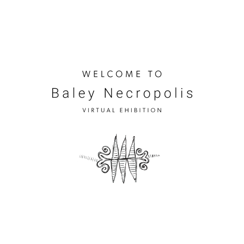
Implementing Digital Documentation Techniques for Archaeological Artifacts to Develop a Virtual Exhibition: the Necropolis of Baley CollectionOut of the storeroom and into the virtualRecommended by Jitte Waagen based on reviews by Alicia Walsh and 1 anonymous reviewer
This paper (Raykovska et al. 2023) discusses the digital documentation techniques and development of a virtual exhibition for artefacts retrieved from the necropolis of Baley, Bulgaria. The principal aim of this particular project is a solid one, trying to provide a solution to display artefacts that would otherwise remain hidden in museum storerooms. The paper describes how through a combination of 3D scanning and photogrammetry high quality 3D models have been produced, and provide content for an online virtual exhibition for the scientific community but also the larger public. It is a well-written and concise paper, in which the information on developed methods and techniques are transparently described, and various important aspects of digitization workflows, such as the importance of storing raw data, are addressed. The paper is a timely discussion on this subject, as strategies to develop digital artefact collections and what to do with those are increasingly being researched. Specifically, it discusses a workflow and its results, both in great detail. Although critical reflection on the process, goals and results from various perspectives would have been a valuable addition to the paper (cf., Jeffra 2020, Paardekoper 2019), it nonetheless provides a good practice example of how to approach the creation of a virtual museum. Those who consider projects concerning digital documentation of archaeological artefacts as well as the creation of virtual spaces to use those in for research, education or valorisation purposes would do well to read this paper carefully. References Jeffra, C., Hilditch, J., Waagen, J., Lanjouw, T., Stoffer, M., de Gelder, L., and Kim, M. J. (2020). Blending the Material and the Digital: A Project at the Intersection of Museum Interpretation, Academic Research, and Experimental Archaeology. The EXARC Journal, 2020(4). https://exarc.net/ark:/88735/10541 Paardekooper, R.P. (2019). Everybody else is doing it, so why can’t we? Low-tech and High-tech approaches in archaeological Open-Air Museums. The EXARC Journal, 2019(4). https://exarc.net/ark:/88735/10457/ Raykovska, M., Jones, K., Klecherova, H., Alexandrov, S., Petkov, N., Hristova, T., and Ivanov, G. (2023). Implementing Digital Documentation Techniques for Archaeological Artifacts to Develop a Virtual Exhibition: the Necropolis of Baley Collection. https://doi.org/10.5281/zenodo.10091870 | Implementing Digital Documentation Techniques for Archaeological Artifacts to Develop a Virtual Exhibition: the Necropolis of Baley Collection | Raykovska Miglena, Jones Kristen, Klecherova Hristina, Alexandrov Stefan, Petkov Nikolay, Hristova Tanya, Ivanov Georgi | <p>Over the past decade, virtual reality has been quickly growing in popularity across disciplines including the field of archaeology and cultural heritage. Despite numerous artifacts being uncovered each year by archaeological excavations around ... | | Ceramics, Computational archaeology, Conservation/Museum studies | Jitte Waagen | 2023-06-12 14:02:44 | ||
28 Aug 2023
Geometric Morphometric Analysis of Projectile Points from the Southwest United States2D Geometric Morphometrics of Projectile Points from the Southwestern United StatesRecommended by Adrian L. Burke based on reviews by James Conolly and 1 anonymous reviewerBischoff (2023) is a significant contribution to the growing field of geometric morphometric analysis in stone tool analysis. The subject is projectile points from the southwestern United States. Projectile point typologies or systematics remain an important part of North American archaeology, and in fact these typologies continue to be used primarily as cultural-historical markers. This article looks at projectile point types using a 2D image geometric morphometric analysis as a way of both improving on projectile point types but also testing if these types are in fact based in measurable reality. A total of 164 point outlines are analyzed using Elliptical Fourier, semilandmark and landmark analyses. The author also uses a network analysis to look at possible relationships between projectile point morphologies in space. This is a clever way of working around the predefined distributions of projectile point types, some of which are over 100 years old. Because of the dynamic nature of stone tools in terms of their use, reworking and reuse, this article can also provide solutions for studying the dynamic nature of stone tools. This article therefore also has a wide applicability to other stone tool analyses. Reference Bischoff, R. J. (2023) Geometric Morphometric Analysis of Projectile Points from the Southwest United States, SocArXiv, a6wjc, ver. 8 peer-reviewed and recommended by Peer Community in Archaeology. https://doi.org/10.31235/osf.io/a6wjc | Geometric Morphometric Analysis of Projectile Points from the Southwest United States | Robert J. Bischoff | <p style="text-align: justify;">Traditional analyses of projectile points often use visual identification, the presence or absence of discrete characteristics, or linear measurements and angles to classify points into distinct types. Geometric mor... | | Archaeometry, Computational archaeology, Lithic technology, North America | Adrian L. Burke | 2022-12-18 03:38:14 | ||
12 Dec 2022
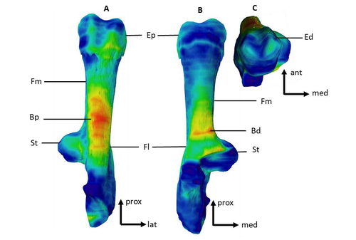
Can growth in captivity alter the calcaneal microanatomy of a wild ungulate?Mobility in pigs: A microanatomical perspectiveRecommended by Nimrod Marom based on reviews by Max Price and Ignacio A. Lazagabaster
Pig domestication and husbandry involved complex processes of introduction, introgression, and feralization that challenge our understanding of human/suid interactions in ancient times. This challenge is a constant stimulus for the development of novel methods and techniques to illuminate aspects of early pig husbandry, such as human-induced changes in mobility. Using geometric morphometrics, Harbers et al. (2020) have shown that the calcaneus records a plastic response to reduced mobility and hence to human management. In the present study, Cottereau et al. (2022) explore the possibility that a similar plastic response to different mobility regimes can be observed in the microanatomy of the calcaneus using CT scans. Their research utilizes a sample of calcanei obtained from Mesolithic specimens, and also from recent suids kept in natural habitat, large pen, and stall. Their results suggest that bone microanatomy is more affected by population differences than by mobility patterns, as illustrated by the similarity between Mesolitic boar calcanei and their difference from recent, free wild boar.
References Cottereau R, Ortiz K, Locatelli Y, Houssaye A, Cucchi T (2022), bioRxiv, 504790, ver. 5 peer-reviewed and recommended by Peer Community in Archaeology. https://doi.org/10.1101/2022.08.22.504790 Harbers H, Neaux D, Ortiz K, Blanc B, Laurens F, Baly I, Callou C, Schafberg R, Haruda A, Lecompte F, Casabianca F, Studer J, Renaud S, Cornette R, Locatelli Y, Vigne J-D, Herrel A, Cucchi T (2020) The mark of captivity: plastic responses in the ankle bone of a wild ungulate (Sus scrofa). Royal Society Open Science, 7, 192039. https://doi.org/10.1098/rsos.192039
| Can growth in captivity alter the calcaneal microanatomy of a wild ungulate? | Romain Cottereau, Katia Ortiz, Yann Locatelli, Alexandra Houssaye*, Thomas Cucchi* | <p style="text-align: justify;">Reduced mobility associated with captivity induce changes in biomechanical stress on the skeleton of domesticated animals. Due to bone plasticity, the morphology and the internal structure of the bones can respond t... | | Neolithic, Zooarchaeology | Nimrod Marom | 2022-08-26 20:29:01 | ||
05 Jun 2023
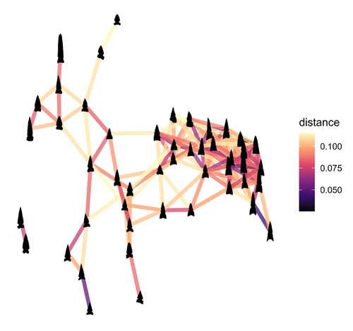
SEAHORS: Spatial Exploration of ArcHaeological Objects in R ShinyAnalyzing piece-plotted artifacts just got simpler: A good solution to the wrong problem?Recommended by Reuven Yeshurun based on reviews by Frédéric Santos, Jacqueline Meier and Maayan LevPaleolithic archaeologists habitually measure 3-coordinate data for artifacts in their excavations. This was first done manually, and in the last three decades it is usually performed by a total station and associated hardware. While the field recording procedure is quite straightforward, visualizing and analyzing the data are not, often requiring specialized proprietary software or coding expertise. Here, Royer and colleagues (2023) present the SEAHORS application, an elegant solution for the post-excavation analysis of artifact coordinate data that seems to be instantly useful for numerous archaeologists. SEAHORS allows one to import and organize field data (Cartesian coordinates and point description), which often comes in a variety of formats, and to create various density and distribution plots. It is specifically adapted to the needs of archaeologists, is free and accessible, and much simpler to use than many commercial programs. The authors further demonstrate the use of the application in the post-excavation analysis of the Cassenade Paleolithic site (see also Discamps et al., 2019). While in no way detracting from my appreciation of Royer et al.’s (2023) work, I would like to play the devil’s advocate by asking whether, in the majority of cases, field recording of artifacts in three coordinates is warranted. Royer et al. (2023) regard piece plotting as “…indispensable to propose reliable spatial planimetrical and stratigraphical interpretations” but this assertion does not hold in all (or most) cases, where careful stratigraphic excavation employing thin volumetric units would do just as well. Moreover, piece-plotting has some serious drawbacks. The recording often slows excavations considerably, beyond what is needed for carefully exposing and documenting the artifacts in their contexts, resulting in smaller horizontal and vertical exposures (e.g., Gilead, 2002). This typically hinders a fuller stratigraphic and contextual understanding of the excavated levels and features. Even worse, the method almost always creates a biased sample of “coordinated artifacts”, in which the most important items for understanding spatial patterns and site-formation processes – the small ones – are underrepresented. Some projects run the danger of treating the coordinated artifacts as bearing more significance than the sieve-recovered items, preferentially studying the former with no real justification. Finally, the coordinated items often go unassigned to a volumetric unit, effectively disconnecting them from other types of data found in the same depositional contexts. The advantages of piece-plotting may, in some cases, offset the disadvantages. But what I find missing in the general discourse (certainly not in the recommended preprint) is the “theory” behind the seemingly technical act of 3-coordinate recording (Yeshurun, 2022). Being in effect a form of sampling, this practice needs a rethink about where and how to be applied; what depositional contexts justify it, and what the goals are. These questions should determine if all “visible” artifacts are plotted, or just an explicitly defined sample of them (e.g., elongated items above a certain length threshold, which should be more reliable for fabric analysis), or whether the circumstances do not actually justify it. In the latter case, researchers sometimes opt for using “virtual coordinates” within in each spatial unit (typically 0.5x0.5 m), essentially replicating the data that is generated by “real” coordinates and integrating the sieve-recovered items as well. In either case, Royer et al.’s (2023) solution for plotting and visualizing labeled points within intra-site space would indeed be an important addition to the archaeologists’ tool kits.
References cited Discamps, E., Bachellerie, F., Baillet, M. and Sitzia, L. (2019). The use of spatial taphonomy for interpreting Pleistocene palimpsests: an interdisciplinary approach to the Châtelperronian and carnivore occupations at Cassenade (Dordogne, France). Paleoanthropology 2019, 362–388. https://doi.org/10.4207/PA.2019.ART136 Gilead, I. (2002). Too many notes? Virtual recording of artifacts provenance. In: Niccolucci, F. (Ed.). Virtual Archaeology: Proceedings of the VAST Euroconference, Arezzo 24–25 November 2000. BAR International Series 1075, Archaeopress, Oxford, pp. 41–44. Royer, A., Discamps, E., Plutniak, S. and Thomas, M. (2023). SEAHORS: Spatial Exploration of ArcHaeological Objects in R Shiny Zenodo, 7957154, ver. 2 peer-reviewed and recommended by Peer Community in Archaeology. https://doi.org/10.5281/zenodo.7929462 Yeshurun, R. (2022). Intra-site analysis of repeatedly occupied camps: Sacrificing “resolution” to get the story. In: Clark A.E., Gingerich J.A.M. (Eds.). Intrasite Spatial Analysis of Mobile and Semisedentary Peoples: Analytical Approaches to Reconstructing Occupation History. University of Utah Press, pp. 27–35.
| SEAHORS: Spatial Exploration of ArcHaeological Objects in R Shiny | ROYER, Aurélien, DISCAMPS, Emmanuel, PLUTNIAK, Sébastien, THOMAS, Marc | <p style="text-align: justify;">This paper presents SEAHORS, an R shiny application available as an R package, dedicated to the intra-site spatial analysis of piece-plotted archaeological remains. This open-source script generates 2D and 3D scatte... | | Computational archaeology, Spatial analysis, Theoretical archaeology | Reuven Yeshurun | 2023-02-24 16:01:44 | ||
11 Oct 2023
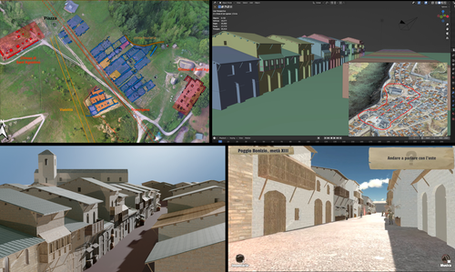
Transforming the Archaeological Record Into a Digital Playground: a Methodological Analysis of The Living Hill ProjectGamification of an archaeological park: The Living Hill Project as work-in-progressRecommended by Sebastian Hageneuer based on reviews by Andrew Reinhard, Erik Champion and 1 anonymous reviewer
This paper (2023) describes The Living Hill project dedicated to the archaeological park and fortress of Poggio Imperiale in Poggibonsi, Italy. The project is a collaboration between the Poggibonsi excavation and Entertainment Games App, Ltd. From the start, the project focused on the question of the intended audience rather than on the used technology. It was therefore planned to involve the audience in the creation of the game itself, which was not possible after all due to the covid pandemic. Nevertheless, the game aimed towards a visit experience as close as possible to reality to offer an educational tool through the video game, as it offers more periods than the medieval period showcased in the archaeological park itself. The game mechanics differ from a walking simulator, or a virtual tour and the player is tasked with returning three lost objects in the virtual game. While the medieval level was based on a 3D scan of the archaeological park, the other two levels were reconstructed based on archaeological material. Currently, only a PC version is working, but the team works on a mobile version as well and teased the possibility that the source code will be made available open source. Lastly, the team also evaluated the game and its perception through surveys, interviews, and focus groups. Although the surveys were only based on 21 persons, the results came back positive overall. The paper is well-written and follows a consistent structure. The authors clearly define the goals and setting of the project and how they developed and evaluated the game. Although it has be criticized that the game is not playable yet and the size of the questionnaire is too low, the authors clearly replied to the reviews and clarified the situation on both matters. They also attended to nearly all of the reviewers demands and answered them concisely in their response. In my personal opinion, I can fully recommend this paper for publication. For future works, it is recommended that the authors enlarge their audience for the quesstionaire in order to get more representative results. It it also recommended to make the game available as soon as possible also outside of the archaeological park. I would also like to thank the reviewers for their concise and constructive criticism to this paper as well as for their time. References Mariotti, Samanta. (2023) Transforming the Archaeological Record Into a Digital Playground: a Methodological Analysis of The Living Hill Project, Zenodo, 8302563, ver. 5 peer-reviewed and recommended by Peer Community in Archaeology https://doi.org/10.5281/zenodo.8302563 | Transforming the Archaeological Record Into a Digital Playground: a Methodological Analysis of *The Living Hill* Project | Samanta Mariotti | <p>Video games are now recognised as a valuable tool for disseminating and enhancing archaeological heritage. In Italy, the recent institutionalisation of Public Archaeology programs and incentives for digital innovation has resulted in a prolifer... | | Conservation/Museum studies, Europe, Medieval, Post-medieval | Sebastian Hageneuer | 2023-08-30 20:25:32 | ||
12 Feb 2024
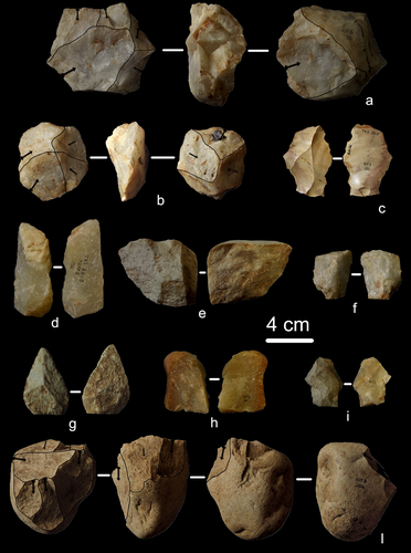
First evidence of a Palaeolithic occupation of the Po plain in Piedmont: the case of Trino (north-western Italy)Not Simply the Surface: Manifesting Meaning in What Lies Above.Recommended by Marcel Kornfeld based on reviews by Lawrence Todd, Jason LaBelle and 2 anonymous reviewersThe archaeological record comes in many forms. Some, such as buried sites from volcanic eruptions or other abrupt sedimentary phenomena are perhaps the only ones that leave relatively clean snapshots of moments in the past. And even in those cases time is compressed. Much, if not all other archaeological record is a messy affair. Things, whatever those things may be, artifacts or construction works (i.e., features), moved, modified, destroyed, warped and in a myriad of ways modified from their behavioral contexts. Do we at some point say the record is worthless? Not worth the effort or continuing investigation. Perhaps sometimes this may be justified, but as Daffara and colleagues show, heavily impacted archaeological remains can give us clues and important information about the past. Thoughtful and careful prehistorians can make significant contributions from what appear to be poor archaeological records. In the case of Daffara and colleagues, a number of important theoretical cross-sections can be recognized. For a long time surface archaeology was thought of simply as a way of getting a preliminary peak at the subsurface. From some of the earliest professional archaeologists (e.g., Kidder 1924, 1931; Nelson 1916) to the New Archaeologists of the 1960s, the link between the surface and subsurface was only improved in precision and systematization (Binford et al. 1970). However, at Hatchery West Binford and colleagues not only showed that surface material can be used more reliably to get at the subsurface, but that substantive behavioral inferences can be made with the archaeological record visible on the surface. Much more important are the behavioral implications drawn from surface material. I am not sure we can cite the first attempts at interpreting prehistory from the surface manifestations of the archaeological record, but a flurry of such approaches proliferated in the 1970s and beyond (Dunnell and Dancey 1983; Ebert 1992; Foley 1981). Off-site archaeology, non-site archaeology, later morphing into landscape archaeology all deal strictly with surface archaeological record to aid in understanding the past. With the current paper, Daffara and colleagues (2024) are clearly in this camp. Although still not widely accepted, it is clear that some behaviors (parts of systems) can only be approached from surface archaeological record. It is very unlikely that a future archaeologist will be able to excavate an entire human social/cultural system; people moving from season to season, creating multiple long and short term camps, travelling, procuring resources, etc. To excavate an entire system one would need to excavate 20,000 km2 or some similarly impossible task. Even if it was physically possible to excavate such an enormous area, it is very likely that some of contextual elements of any such system will be surface manifestations. Without belaboring the point, surface archaeological record yields data like any other archaeological record. We must contextual the archaeological artifacts or features weather they come from surface or below. Daffara and colleagues show us that we can learn about deep prehistory of northern Italy, with collections that were unsystematically collected, biased by agricultural as well as other land deformations agents. They carefully describe the regional prehistory as we know it, in particular specific well documented sites and assemblages as a means of applying such knowledge to less well controlled or uncontrolled collections.
References Binford, L., Binford, R. S. R., Whallon, R. and Hardin, M. A. (1970). Archaeology of Hatchery West. Memoirs of the Society for American Archaeology, No. 24, Washington D.C. Daffara, S., Giraudi, C., Berruti, G. L. F., Caracausi, S. and Garanzini, F. (2024). First evidence of a Palaeolithic frequentation of the Po plain in Piedmont: the case of Trino (north-western Italy), OSF Preprints, pz4uf, ver. 6 peer-reviewed and recommended by Peer Community in Archaeology. https://doi.org/10.31219/osf.io/pz4uf Dunnell, R. C. and Dancey, W. S. (1983). The siteless survey: a regional scale data collection strategy. In Advances in Archaeological Method and Theory, vol. 6, edited by Michael B. Schiffer, pp. 267-287. Academic Press, New York. Ebert, J. I. (1992). Distributional Archaeology. University of New Mexico Press, Albuquerque. Foley, R. A. (1981). Off site archaeology and human adaptation in eastern Africa: An analysis of regional artefact density in the Amboseli, Southern Kenya. British Archaeological Reports International Series 97. Cambridge Monographs in African Archaeology 3. Oxford England. Kidder, A. V. (1924). An Introduction to the Study of Southwestern Archaeology, With a Preliminary Account of the Excavations at Pecos. Papers of the Southwestern Expedition, Phillips Academy, no. 1. New Haven, Connecticut. Kidder, A. V. (1931). The Pottery of Pecos, vol. 1. Papers of the Southwestern Expedition, Phillips Academy. New Haven, Connecticut. Nelson, N. (1916). Chronology of the Tano Ruins, New Mexico. American Anthropologist 18(2):159-180. | First evidence of a Palaeolithic occupation of the Po plain in Piedmont: the case of Trino (north-western Italy) | Sara Daffara, Carlo Giraudi, Gabriele L.F. Berruti, Sandro Caracausi, Francesca Garanzini | <p>The Trino hill is an isolated relief located in north-western Italy, close to Trino municipality. The hill was subject of multidisciplinary studies during the 1970s, when, because of quarrying and agricultural activities, five concentrations of... | | Lithic technology, Middle Palaeolithic | Marcel Kornfeld | 2023-10-04 16:58:19 | ||
06 Aug 2023
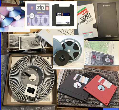
A Focus on the Future of our Tiny Piece of the Past: Digital Archiving of a Long-term Multi-participant Regional ProjectA meticulous description of archiving research data from a long-running landscape research projectRecommended by Isto Huvila based on reviews by Dominik Hagmann and Iwona DudekThe paper “A Focus on the Future of our Tiny Piece of the Past: Digital Archiving of a Long-term Multi-participant Regional Project” (Madry et al., 2023) describes practices, challenges and opportunities encountered in digital archiving of a landscape research project running in Burgundy, France for more than 45 years. As an unusually long-running multi-disciplinary undertaking working with a large variety of multi-modal digital and non-digital data, the Burgundy project has lived through the development of documentation and archiving technologies from the 1970s until today and faced many of the challenges relating to data management, preservation and migration. The major strenght of the paper is that it provides a detailed description of the evolution of digital data archiving practices in the project including considerations about why some approaches were tested and abandoned. This differs from much of the earlier literature where it has been more common to describe individual solutions how digital archiving was either planned or was performed at one point of time. A longitudinal description of what was planned, how and why it has worked or failed so far, as described in the paper, provides important insights in the everyday hurdles and ways forward in digital archiving. As a description of a digital archiving initiative, the paper makes a valuable contribution for the data archiving scholarship as a case description of practices and considerations in one research project. For anyone working with data management in a research project either as a researcher or data manager, the text provides useful advice on important practical matters to consider ahead, during and after the project. The main advice the authors are giving, is to plan and act for data preservation from the beginning of the project rather than doing it afterwards. To succeed in this, it is crucial to be knowledgeable of the key concepts of data management—such as “digital data fixity, redundant backups, paradata, metadata, and appropriate keywords” as the authors underline—including their rationale and practical implications. The paper shows also that when and if unexpected issues raise, it is important to be open for different alternatives, explore ways forward, and in general be flexible. The paper makes also a timely contribution to the discussion started at the session “Archiving information on archaeological practices and work in the digital environment: workflows, paradata and beyond” at the Computer Applications and Quantitative 2023 conference in Amsterdam where it was first presented. It underlines the importance of understanding and communicating the premises and practices of how data was collected (and made) and used in research for successful digital archiving, and the similar pertinence of documenting digital archiving processes to secure the keeping, preservation and effective reuse of digital archives possible. ReferencesMadry, S., Jansen, G., Murray, S., Jones, E., Willcoxon, L. and Alhashem, E. (2023) A Focus on the Future of our Tiny Piece of the Past: Digital Archiving of a Long-term Multi-participant Regional Project, Zenodo, 7967035, ver. 3 peer-reviewed and recommended by Peer Community in Archaeology. https://doi.org/10.5281/zenodo.7967035 | A Focus on the Future of our Tiny Piece of the Past: Digital Archiving of a Long-term Multi-participant Regional Project | Scott Madry, Gregory Jansen, Seth Murray, Elizabeth Jones, Lia Willcoxon, Ebtihal Alhashem | <p>This paper will consider the practical realities that have been encountered while seeking to create a usable Digital Archiving system of a long-term and multi-participant research project. The lead author has been involved in archaeologic... | | Computational archaeology, Environmental archaeology, Landscape archaeology | Isto Huvila | 2023-05-24 18:46:34 | ||
16 Apr 2024
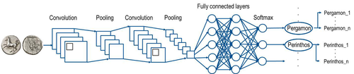
Creating an Additional Class Layer with Machine Learning to counter Overfitting in an Unbalanced Ancient Coin DatasetA significant contribution to the problem of unbalanced data in machine learning research in archaeologyRecommended by Alex Brandsen based on reviews by Simon Carrignon, Joel Santos and 1 anonymous reviewer
This paper [1] presents an innovative approach to address the prevalent challenge of unbalanced datasets in coin type recognition, shifting the focus from coin class type recognition to coin mint recognition. Despite this shift, the issue of unbalanced data persists. To mitigate this, the authors introduce a method to split larger classes into smaller ones, integrating them into an 'additional class layer'. Three distinct machine learning (ML) methodologies were employed to identify new possible classes, with one approach utilising unsupervised clustering alongside manual intervention, while the others leverage object detection, and Natural Language Processing (NLP) techniques. However, despite these efforts, overfitting remained a persistent issue, prompting the authors to explore alternative methods such as dataset improvement and Generative Adversarial Networks (GANs). The paper contributes significantly to the intersection of ML techniques and archaeology, particularly in addressing overfitting challenges. Furthermore, the authors' candid acknowledgment of the limitations of their approaches serves as a valuable resource for researchers encountering similar obstacles. This study stems from the D4N4 project, aimed at developing a machine learning-based coin recognition model for the extensive "Corpus Nummorum" dataset, comprising over 19,600 coin types and 49,000 coins from various ancient landscapes. Despite encountering challenges with overfitting due to the dataset's imbalance, the authors' exploration of multiple methodologies and transparent documentation of their limitations enriches the academic discourse and provides a foundation for future research in this field. Reference [1] Gampe, S. and Tolle, K. (2024). Creating an Additional Class Layer with Machine Learning to counter Overfitting in an Unbalanced Ancient Coin Dataset. Zenodo, 8298077, ver. 4 peer-reviewed and recommended by Peer Community in Archaeology. https://doi.org/10.5281/zenodo.8298077 | Creating an Additional Class Layer with Machine Learning to counter Overfitting in an Unbalanced Ancient Coin Dataset | Sebastian Gampe, Karsten Tolle | <p>We have implemented an approach based on Convolutional Neural Networks (CNN) for mint recognition for our Corpus Nummorum (CN) coin dataset as an alternative to coin type recognition, since we had too few instances for most of the types (classe... | | Computational archaeology | Alex Brandsen | 2023-08-29 16:26:41 |


