
Latest recommendations

| Id | Title * | Authors * | Abstract * | Picture * | Thematic fields * ▲ | Recommender | Reviewers | Submission date | |
|---|---|---|---|---|---|---|---|---|---|
06 Aug 2023

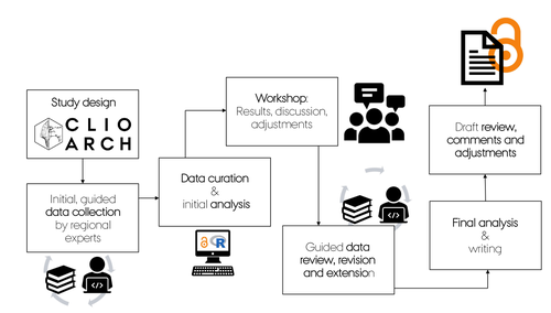
A Focus on the Future of our Tiny Piece of the Past: Digital Archiving of a Long-term Multi-participant Regional ProjectA meticulous description of archiving research data from a long-running landscape research projectRecommended by Isto Huvila based on reviews by Dominik Hagmann and Iwona DudekThe paper “A Focus on the Future of our Tiny Piece of the Past: Digital Archiving of a Long-term Multi-participant Regional Project” (Madry et al., 2023) describes practices, challenges and opportunities encountered in digital archiving of a landscape research project running in Burgundy, France for more than 45 years. As an unusually long-running multi-disciplinary undertaking working with a large variety of multi-modal digital and non-digital data, the Burgundy project has lived through the development of documentation and archiving technologies from the 1970s until today and faced many of the challenges relating to data management, preservation and migration. The major strenght of the paper is that it provides a detailed description of the evolution of digital data archiving practices in the project including considerations about why some approaches were tested and abandoned. This differs from much of the earlier literature where it has been more common to describe individual solutions how digital archiving was either planned or was performed at one point of time. A longitudinal description of what was planned, how and why it has worked or failed so far, as described in the paper, provides important insights in the everyday hurdles and ways forward in digital archiving. As a description of a digital archiving initiative, the paper makes a valuable contribution for the data archiving scholarship as a case description of practices and considerations in one research project. For anyone working with data management in a research project either as a researcher or data manager, the text provides useful advice on important practical matters to consider ahead, during and after the project. The main advice the authors are giving, is to plan and act for data preservation from the beginning of the project rather than doing it afterwards. To succeed in this, it is crucial to be knowledgeable of the key concepts of data management—such as “digital data fixity, redundant backups, paradata, metadata, and appropriate keywords” as the authors underline—including their rationale and practical implications. The paper shows also that when and if unexpected issues raise, it is important to be open for different alternatives, explore ways forward, and in general be flexible. The paper makes also a timely contribution to the discussion started at the session “Archiving information on archaeological practices and work in the digital environment: workflows, paradata and beyond” at the Computer Applications and Quantitative 2023 conference in Amsterdam where it was first presented. It underlines the importance of understanding and communicating the premises and practices of how data was collected (and made) and used in research for successful digital archiving, and the similar pertinence of documenting digital archiving processes to secure the keeping, preservation and effective reuse of digital archives possible. ReferencesMadry, S., Jansen, G., Murray, S., Jones, E., Willcoxon, L. and Alhashem, E. (2023) A Focus on the Future of our Tiny Piece of the Past: Digital Archiving of a Long-term Multi-participant Regional Project, Zenodo, 7967035, ver. 3 peer-reviewed and recommended by Peer Community in Archaeology. https://doi.org/10.5281/zenodo.7967035 | A Focus on the Future of our Tiny Piece of the Past: Digital Archiving of a Long-term Multi-participant Regional Project | Scott Madry, Gregory Jansen, Seth Murray, Elizabeth Jones, Lia Willcoxon, Ebtihal Alhashem | <p>This paper will consider the practical realities that have been encountered while seeking to create a usable Digital Archiving system of a long-term and multi-participant research project. The lead author has been involved in archaeologic... | | Computational archaeology, Environmental archaeology, Landscape archaeology | Isto Huvila | 2023-05-24 18:46:34 | ||
11 Dec 2023
A meta-analysis of Final Palaeolithic/earliest Mesolithic cultural taxonomy and evolution in EuropeQuestioning Final Palaeolithic and early Mesolithic cultural taxonomy with a data-driven statistical approachRecommended by Anaïs Vignoles based on reviews by Dirk Leder and 2 anonymous reviewersCultural taxonomies are an essential tool for archaeologists working with prehistoric material cultures as they have historically been used to create the basic analytical units for studying cultural evolution through time (de Mortillet, 1883 ; Breuil, 1913). This approach has its limits as the taxonomic units are essentially etic constructions, i.e., they are defined in a cultural context exterior to the one that produced the material culture on which they are based (e.g., Pesesse, 2019). But to approach questions related to cultural evolution, one has to define archaeological units with clear geographic and chronological delineations in order to be compared synchronically and diachronically (e.g., Willey and Philips, 1958). In « A meta-analysis of Final Palaeolitic/Earliest Mesolithic cultural taxonomy and evolution in Europe », F. Riede and colleagues propose a novel and interesting approach to question the end of the Palaeolithic and beginning of the Mesolithic’s « named archaeological cultures » (NACs) analytical pertinence (Riede et al., 2023). In this particular context, NACs are indeed very numerous (n = 86) and result from complex and regional research histories. It seems thus pertinent to question the extent to which the said NACs chronological and geographic patterns result from past cultural diversity and evolution, and are not artefacts of research. To do so, the authors adopted a data-driven approach that they describe in detail in the paper. First, they gathered an European data base of lithic tool-kit composition, blade and bladelet technology and armature morphology at 350 key sites considered representative of NACs, dated between 15 and 11 ka (Hussain et al., 2023). These data were then analyzed using geometric morphometrics and a set of statisticaal tests in order to 1) test the coherence of these taxonomic units, and 2) test the chronological change in artefact shape variation. The authors conclude that the data set is partially biased by reasearch practices and histories, as their data-driven approach has only partially replicated traditional NACs for the european Late Palaeolithic/Early Mesolithic. However, their analysis of armature shape evolution has shown a tendency to diversification overtime, a pattern that was already observed in more « traditional » approaches. This study is, in my opinion, an excellent contribution for a significant step in macro-regional approaches to the archaeological record: defining discrete archaeological units that serve as a basis for subsequent analyses aimed at delineating cultural evolutionary processes. The authors propose a carefully designed and statistically grounded procedure in order to achieve these definitions in the most replicable and explicit possible manner. Taking advantage of drawings as a primary source of information is also very original despite several limitations of this approach (such as the necessary selection of most typical artefacts to be represented, the incompleteness of data publication or the difficulty to access all published work across such a large geographic area). The results of the study are convincing enough to allow the authors to discuss the pertinence of European Late Paleo/Early Mesolithic NACs, the potential epistemological and historical factors that could affect this taxonomic framework, as well as to give more weight to the traditional hypothesis of lithic cultural diversification towards the end of the Pleistocene/beginning of the Holocene in Europe. I would also like to underline the authors’ important efforts to ensure transparence and replicability of their study, as well as the accessibility of the data, thanks to extensive supplementary data and a data paper describing their data set in detail. Anaïs L. Vignoles References Breuil, H. (1913). Les subdivisions du paléolithique supérieur et leur signification. In Congrès international d’anthropologie et d’archéologie préhistoriques - compte-rendu de la XIVème session, tome 1:165‑238. Genève: Imprimerie Albert Kündig. Hussain, S. T., Riede, F., Matzig, D. N., Biard, M., Crombé, P., Fernández-Lopéz de Pablo, J., Fontana, F., Groß, D., Hess, T., Langlais, M., Mevel, L., Mills, W., Moník, M., Naudinot, N., Posch, C., Rimkus, T., Stefański, D. and Vandendriessche, H. (2023). A Pan-European Dataset Revealing Variability in Lithic Technology, Toolkits, and Artefact Shapes ~15-11 Kya. Scientific Data 10 (1): 593. https://doi.org/10.1038/s41597-023-02500-9. Mortillet, G. (1883). Le Préhistorique, antiquité de l’homme. Reinwald. Paris. Pesesse, D. (2019). Analyser un silex, le façonner à nouveau ? Sur certains usages de la chaîne opératoire au Paléolithique supérieur. Techniques & culture, no 71: 74‑77. https://doi.org/10.4000/tc.11321. Riede, F., Matzig, D. N., Biard, M., Crombé, P., Fernández-Lopéz de Pablo, J., Fontana, F., Groß, D., Hess, T., Langlais, M., Mevel, L., Mills, W., Moník, M., Naudinot, N., Posch, C., Rimkus, T., Stefański, D., Vandendriessche, H. and Hussain, S. T. (2023). A meta-analysis of Final Palaeolithic/earliest Mesolithic cultural taxonomy and evolution in Europe, Zenodo, 8195587., ver. 3 peer-reviewed and recommended by Peer Community in Archaeology. https://doi.org/10.5281/zenodo.8195587 Willey, G. R. and Phillips, P. (1958). Method and Theory in American Archaeology. Chicago, IL: The University of Chicago Press. | A meta-analysis of Final Palaeolithic/earliest Mesolithic cultural taxonomy and evolution in Europe | Felix Riede, David N. Matzig, Miguel Biard, Philippe Crombé, Javier Fernández-Lopéz de Pablo, Federica Fontana, Daniel Groß, Thomas Hess, Mathieu Langlais, Ludovic Mevel, William Mills, Martin Moník, Nicolas Naudinot, Caroline Posch, Tomas Rimkus,... | <p>Archaeological systematics, together with spatial and chronological information, are commonly used to infer cultural evolutionary dynamics in the past. For the study of the Palaeolithic, and particularly the European Final Palaeolithic and earl... | | Computational archaeology, Europe, Lithic technology, Mesolithic, Upper Palaeolithic | Anaïs Vignoles | 2023-07-29 16:06:17 | ||
10 Jan 2024
Linking Scars: Topology-based Scar Detection and Graph Modeling of Paleolithic Artifacts in 3DA valuable contribution to automated analysis of palaeolithic artefactsRecommended by Sebastian Hageneuer based on reviews by Lutz Schubert and 1 anonymous reviewer based on reviews by Lutz Schubert and 1 anonymous reviewer
In this paper (Linsel/Bullenkamp/Mara 2024), the authors propose an automatic system for scar-ridge-pattern detection on palaeolithic artefacts based on Morse Theory. Scare-Ridge pattern recognition is a process that is usually done manually while creating a drawing of the object itself. Automatic systems to detect scars or ridges exist, but only a small amount of them is utilizing 3D data. In addition to the scar-ridges detection, the authors also experiment in automatically detecting the operational sequence, the temporal relation between scars and ridges. As a result, they can export a traditional drawing as well as graph models displaying the relationships between the scars and ridges. After an introduction to the project and the practice of documenting palaeolithic artefacts, the authors explain their procedure in automatising the analysis of scars and ridges as well as their temporal relation to each other on these artefacts. To illustrate the process, an open dataset of lithic artefacts from the Grotta di Fumane, Italy, was used and 62 artefacts selected. To establish a Ground Truth, the artefacts were first annotated manually. The authors then continue to explain in detail each step of the automated process that follows and the results obtained. In the second part of the paper, the results are presented. First the results of the segmentation process shows that the average percentage of correctly labelled vertices is over 91%, which is a remarkable result. The graph modelling however shows some more difficulties, which the authors are aware of. To enhance the process, the authors rightfully aim to include datasets of experimental archaeology in the future. They also aim to develop a way of detecting the operational sequence automatically and precisely. This paper has great potential as it showcases exactly what Digital and Computational Archaeology is about: The development of new digital methods to enhance the analysis of archaeological data. While this procedure is still in development, the authors were able to present a valuable contribution to the automatization of analytical archaeology. By creating a step towards the machine-readability of this data, they also open up the way to further steps in machine learning within Archaeology. BibliographyLinsel, F., Bullenkamp, J. P., and Mara, H. (2024). Linking Scars: Topology-based Scar Detection and Graph Modeling of Paleolithic Artifacts in 3D, Zenodo, 8296269, ver. 3 peer-reviewed and recommended by Peer Community in Archaeology. https://doi.org/10.5281/zenodo.8296269 | Linking Scars: Topology-based Scar Detection and Graph Modeling of Paleolithic Artifacts in 3D | Florian Linsel, Jan Philipp Bullenkamp & Hubert Mara | <p>Motivated by the concept of combining the archaeological practice of creating lithic artifact drawings with the potential of 3D mesh data, our goal in this project is not only to analyze the shape at the artifact level, but also to enable a mor... | | Computational archaeology, Europe, Lithic technology, Upper Palaeolithic | Sebastian Hageneuer | 2023-09-01 23:03:59 | ||
22 Apr 2024
The transformation of an archaeological community and its resulting representations in the context of the co-development of open Archaeological Information SystemsExploring The Role of Archaeological Information Systems in Improving Data Management and InteroperabilityRecommended by James Stuart Taylor based on reviews by 2 anonymous reviewers
In response to the feedback provided by the reviewers, the authors have undertaken a comprehensive revision of the manuscript [1]. These revisions have specifically targeted the primary concerns raised regarding the clarity and structure of the argument concerning the transformative impact of Archaeological Information Systems (AIS) on archaeological practices. In my view the revised manuscript now more clearly articulates the distinction between internal and external interoperability and emphasizes the critical importance of integrating contextual information with archaeological data. This approach directly addresses the previously identified need for enhanced traceability and usability of archaeological data, ensuring that the manuscript's contributions to the field are both clear and impactful. Moreover, the application of the proposed model at the Bibracte site is illustrated with greater clarity, serving as a concrete example of how the challenges associated with documentation and data management can be effectively addressed through the methodologies proposed in the paper. This practical demonstration enriches the manuscript, providing readers with a much clearer understanding of the model's applicability and benefits in real-world archaeological practice. The authors have also made significant efforts to refine the overall structure and coherence of the manuscript. By making complex concepts more accessible and ensuring a cohesive narrative flow throughout, the manuscript now offers a more engaging and comprehensible read. This has been achieved through careful rephrasing and restructuring of sections, particularly those relating to the T!O model's application and the conclusion, thereby enhancing reader engagement and comprehension. Alongside these structural and conceptual clarifications, explicit discussion of potential areas for future research, not only acknowledges the limitations of the current study but also highlights the significant potential for digital technologies to contribute to archaeological methodology and knowledge production. As such, the manuscript opens up new avenues for exploration and invites further scholarly engagement with the topics it addresses. I believe, these revisions address the earlier feedback quite comprehensively, presenting a robust and compelling argument for the adoption of collaborative and technologically informed approaches in the field of archaeology. The manuscript now stands as a strong example of the critical role AIS could/should play in transforming archaeological practices, offering valuable insights into how these kinds of systems might enhance the management, accessibility, and understanding of archaeological data. Through this revised submission, the authors have significantly strengthened their contribution to the ongoing discourse on digital archaeology, demonstrating the practical and theoretical implications of their work for the broader archaeological community. I am happy, therefore to recommend this paper for acceptence. Reference [1] Lacombe, E., Lukas, D. and Durost, S. (2024). The transformation of an archaeological community and its resulting representations in the context of the co-development of open Archaeological Information Systems. Zenodo, 8309732, ver. 3 peer-reviewed and recommended by Peer Community in Archaeology. https://doi.org/10.5281/zenodo.8309732
| The transformation of an archaeological community and its resulting representations in the context of the co-development of open Archaeological Information Systems | Eric Lacombe, Dominik Lukas, Sébastien Durost | <p>The adoption of Archaeological Information Systems (AIS) evolves according to multiple factors, both human and technical, as well as endogenous and exogenous. In consequence the ever increasing scope of digital tools, which allow for the organi... | | Computational archaeology, Europe, Protohistory, Theoretical archaeology | James Stuart Taylor | 2023-09-01 18:58:26 | ||
12 Apr 2024
Survey Planning, Allocation, Costing and Evaluation (SPACE) Project: Developing a Tool to Help Archaeologists Conduct More Effective SurveysA new tool to increase the robustness of archaeological field surveyRecommended by Jitte Waagen based on reviews by Philip Verhagen and Tymon de Haas
This well-written and interesting paper ‘Survey Planning, Allocation, Costing and Evaluation (SPACE) Project: Developing a Tool to Help Archaeologists Conduct More Effective Surveys’ deals with the development of a ‘modular, accessible, and simple web-based platform for survey planning and quality assurance’ in the area of pedestrian field survey methods (Banning et al. 2024). Although there have been excellent treatments of statistics in archaeological field survey (among which various by the first author: Banning 2020, 2021), and there is continuous methodological debate on platforms such as the International Mediterranean Survey Workshop (IMSW), in papers dealing with the current development and state of the field (Knodell et al. 2023), good practices (Attema et al. 2020) or the merits of a quantifying approach to archaeological densities (cf. de Haas et al. 2023), this paper rightfully addresses the lack of rigorous statistical approaches in archaeological field survey. As argued by several scholars such as Orton (2000), this mainly appears the result of lack of knowledge/familiarity/resources to bring in the required expertise etc. with the application of seemingly intricate statistics (cf. Waagen 2022). In this context this paper presents a welcome contribution to the feasibility of a robust archaeological field survey design. The SPACE application, under development by the authors, is introduced in this paper. It is a software tool that aims to provide different modules to assist archaeologists to make calculations for sample size, coverage, stratification, etc. under the conditions of survey goals and available resources. In the end, the goal is to ensure archaeological field surveys will attain their objectives effectively and permit more confidence in the eventual outcomes. The module concerning Sweep Widths, an issue introduced by the main author in 2006 (Banning 2006) is finished; the sweep width assessment is a methodology to calibrate one’s survey project for artefact types, landscape, visibility and person-bound performance, eventually increasing the quality (comparability) of the collected samples. This is by now a well-known calibration technique, yet little used, so this effort to make that more accessible is certainly laudable. An excellent idea, and another aim of this project, is indeed to build up a database with calibration data, so applying sweep-width corrections will become easier accessible to practitioners who lack time to set up calibration exercises. It will be very interesting to have a closer look at the eventual platform and to see if, and how, it will be adapted by the larger archaeological field survey community, both from an academic research perspective as from a heritage management point of view. I happily recommend this paper and all debate relating to it, including the excellent peer reviews of the manuscript by Philip Verhagen and Tymon de Haas (available as part of this PCI recommendation procedure), to any practitioner of archaeological field survey. References Attema, P., Bintliff, J., Van Leusen, P.M., Bes, P., de Haas, T., Donev, D., Jongman, W., Kaptijn, E., Mayoral, V., Menchelli, S., Pasquinucci, M., Rosen, S., García Sánchez, J., Luis Gutierrez Soler, L., Stone, D., Tol, G., Vermeulen, F., and Vionis. A. 2020. “A guide to good practice in Mediterranean surface survey projects”, Journal of Greek Archaeology 5, 1–62. https://doi.org/10.32028/9781789697926-2 Banning, E.B., Alicia L. Hawkins, S.T. Stewart, Sweep widths and the detection of artifacts in archaeological survey, Journal of Archaeological Science, Volume 38, Issue 12, 2011, Pages 3447-3458. https://doi.org/10.1016/j.jas.2011.08.007 Banning, E.B. 2020. Spatial Sampling. In: Gillings, M., Hacıgüzeller, P., Lock, G. (eds.) Archaeological Spatial Analysis. A Methodological Guide. Routledge. Banning, E.B. 2021. Sampled to Death? The Rise and Fall of Probability Sampling in Archaeology. American Antiquity, 86(1), 43-60. https://doi.org/10.1017/aaq.2020.39 Banning, E. B. Steven Edwards, & Isaac Ullah. (2024). Survey Planning, Allocation, Costing and Evaluation (SPACE) Project: Developing a Tool to Help Archaeologists Conduct More Effective Surveys. Zenodo, 8072178, ver. 9 peer-reviewed and recommended by Peer Community in Archaeology. https://doi.org/10.5281/zenodo.8072178 Knodell, A.R., Wilkinson, T.C., Leppard, T.P. et al. 2023. Survey Archaeology in the Mediterranean World: Regional Traditions and Contributions to Long-Term History. J Archaeol Res 31, 263–329 (2023). https://doi.org/10.1007/s10814-022-09175-7 Orton, C. 2000. Sampling in Archaeology. Cambridge University Press. https://doi.org/10.1017/CBO9781139163996 Waagen, J. 2022. Sampling past landscapes. Methodological inquiries into the bias problems of recording archaeological surface assemblages. PhD-Thesis. https://hdl.handle.net/11245.1/e9cb922c-c7e4-40a1-b648-7b8065c46880 de Haas, T., Leppard, T. P., Waagen, J., & Wilkinson, T. (2023). Myopic Misunderstandings? A Reply to Meyer (JMA 35(2), 2022). Journal of Mediterranean Archaeology, 36(1), 127-137. https://doi.org/10.1558/jma.27148 | Survey Planning, Allocation, Costing and Evaluation (SPACE) Project: Developing a Tool to Help Archaeologists Conduct More Effective Surveys | E. B. Banning, Steven Edwards, and Isaac Ullah | <p>Designing an effective archaeological survey can be complicated and confidence that it was effective requires post-survey evaluation. The goal of SPACE is to develop software to facilitate survey designers’ decisions and partially automate tool... | | Computational archaeology, Landscape archaeology | Jitte Waagen | 2023-06-28 13:42:28 | ||
27 Jun 2024
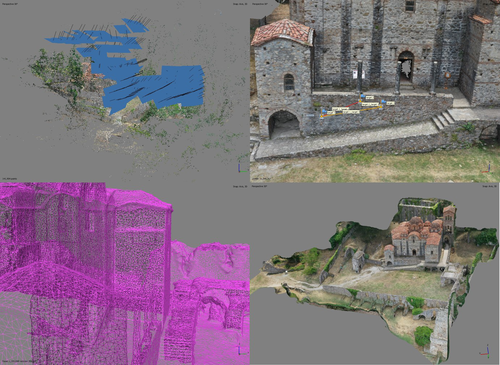
At the edge of the city: the digital storyline of the Bronchotion Monastery of MystrasMystras Captured from the Air – Digital Recording Techniques for Cultural Heritage Management of a Monumental Archaeological SiteRecommended by Jitte Waagen based on reviews by Nikolai Paukkonen and 1 anonymous reviewer
This paper (Panagiotidis et al. 2024) discusses the digital approach to the ‘digital storyline’ of the Monastery of Brontochion of Mystras, Peloponnese, Greece. Using drone and terrestrial photogrammetric recording techniques, their goal is to produce maps and 3D models that will be integrated in the overall study of the medieval city, as well as function as a comprehensive visualisation of the archaeological site throughout its history. This will take shape as a web application using ArcGIS Online that will be a valuable platform presenting interactive visual information to accompany written publications. In addition, the assets in the database will be available for further advanced purposes, such as suggested by the authors; xR applications, educational games or digital smart guides. The authors of the paper do a good job in describing the historical background of the site and the purpose of the digital documentation techniques, and the applied methods and the technical details of the produced models are dealt with in detail. The paper presents a compelling case for an integrative approach to using digital recording techniques at an architectonically complex site for Cultural Heritage Management. It can be placed in a series of studies discussing how monumental sites can benefit from advanced digital recording techniques such as those presented in this paper (see for example Waagen and Wijngaarden 2024). The paper is recommended as an interesting read for all who are involved in this field. References Panagiotidis V. Vayia, Valantou Vasiliki, Kazolias Anastasios, and Zacharias Nikolaos. (2024). At the Edge of a City: The Digital Storyline of the Brontochion Monastery of Mystras. Zenodo, 8126952, ver. 3 peer-reviewed and recommended by Peer Community in Archaeology. https://doi.org/10.5281/zenodo.8126952 Waagen, J., and van Wijngaarden, G. J. (2024). Understanding Archaeological Site Topography: 3D Archaeology of Archaeology. Journal of Computer Applications in Archaeology, 7(1), 237–243. https://doi.org/10.5334/jcaa.157 | At the edge of the city: the digital storyline of the Bronchotion Monastery of Mystras | Panagiotidis V. Vayia; Valantou Vasiliki; Kazolias Anastasios; Zacharias Nikolaos | <p>This study focuses on the digital depiction of the storyline of the Monastery of Brontochion of Mystras, located at the southwest edge of the city of Mystras, situated at the foot of Mt. Taygetos, six kilometres west of the city of Sparta in th... | | Computational archaeology, Landscape archaeology, Mediterranean, Remote sensing, Spatial analysis | Jitte Waagen | 2023-10-03 17:02:54 | ||
12 Feb 2024
3Duewelsteene - A website for the 3D visualization of the megalithic passage grave Düwelsteene near Heiden in Westphalia, GermanyOnline presentation of the digital reconstruction process of a megalithic tomb : “3Duewelsteene”Recommended by Sophie C. Schmidt and James Allison based on reviews by Robert Bischoff, Ronald Visser and Scott Ure
“3Duewelsteene - A website for the 3D visualization of the megalithic passage grave Düwelsteene near Heiden in Westphalia, Germany” (Tharandt 2024) presents several 3-dimensional models of the Düwelsteene monument, along with contextual information about the grave and the process of creating the models. The website (https://3duewelsteene.github.io/) includes English and German versions, making it accessible to a wide audience. The website itself serves as the primary means of presenting the data, rather than as a supplement to a written text. This is an innovative and engaging way to present the research to a wider public. Düwelsteene (“Devil’s Stones”) is a megalithic passage grave from the Funnel Beaker culture, dating to approximately 3300 BC. to 2600 BC. that was excavated in 1932. The website displays three separate 3-dimensional models. They ares shown in the 3D viewer software 3DHOP, which enables viewers to interact with the models in several ways, Annotations on the models display further information. The first model was created by image-based modeling and shows the monument as it appears today. A second model uses historical photographs and excavation data to reconstruct the grave as it appeared prior to the 1932 archaeological excavation. Restoration work following the excavation relocated many of the stones. Pre-1932 photographs collected from residents of the nearby town of Heiden were then used to create a model showing what the tomb looked like before the restoration work. It is commendable that a “certainty view” of the model shows the certainty with which the stones can be put at the reconstructed place. Gaps in the 3D models of stones that were caused by overlap with other stones have been filled with a rough mesh and marked as such, thereby differentiating between known and unknown parts of the stones. The third model is the most imaginative and most interesting. As it shows as the grave as it might have appeared in approximately 3000 B.C., many aspects of this model are necessarily somewhat speculative. There is no direct evidence for exact size and shape of the capstones, the height of the mound, and other details. But enough is known about other similar constructions to allow these details to be inferred with some confidence. Again, care was taken to enable viewers to distinguish between the stones that are still in existence and those that were reconstructed. A video on the home page of the website adds a nice touch. It starts with the model of the Düwelsteene as it currently appears then shows, in reverse order, the changes to the grave, ending with the inferred original state. The 3D reconstructions are convincing and the methods well described. This project follows an open science approach and the FAIR principles, which is commendable and cutting edge in the field of Digital Archaeology. The preprint of the website hosted on zenodo includes all the photos, text, html files, and nine individual 3D model (.ply) files that are combined in the reconstructions exhibited on the website. A “readme.md” file includes details about building the models using CloudCompare and Blender, and modifications to the 3D viewer software (3DHOP) to get the website to improve the display of the reconstructions. We have to note that the link between the reconstructed models and the html page does not work when the files are downloaded from zenodo and opened offline. The html pages open in the browser, and the individual ply files work fine, but the 3D models do not display on the browser page when the html files are opened offline. The online version of the website is working perfectly. The 3Düwelsteene website combines the presentation of archaeological domain knowledge to a lay audience as well as in-depths information on the reconstruction process to make it an interesting contribution for researchers. By providing data and code for the website it also models an Open Science approach, which enables other researchers to re-use these materials. We congratulate the author on a successful reconstruction of the megalithic tomb, an admirable presentation of the archaeological work and the thoughtful outreach to a broad audience. Bibliography | 3Duewelsteene - A website for the 3D visualization of the megalithic passage grave Düwelsteene near Heiden in Westphalia, Germany | Tharandt, Louise | <p>The Düwelsteene near Heiden, Westphalia, is one of the most southern megalithic tombs of the Funnel Beaker culture. In 1932 the Düwelsteene were restored and the appearance of the grave was changed. Even though the megalithic tomb was excavated... | | Computational archaeology, Mesolithic, Neolithic | Sophie C. Schmidt | 2023-05-21 17:24:22 | ||
01 Dec 2022
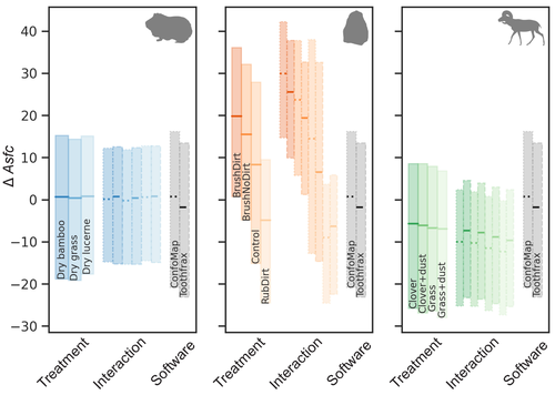
Surface texture analysis in Toothfrax and MountainsMap® SSFA module: Different software packages, different results?An important comparison of software for Scale Sensitive Fractal Analysis : are ancient and new results compatible?Recommended by Alain Queffelec and Florent Rivals based on reviews by Antony Borel and 2 anonymous reviewers
The community of archaeologists, bioanthropologist and paleontologists relying on tools use-wear and dental microwear has grown in the recent years, mainly driven by the spread of confocal microscopes in the laboratories. If the diversity of microscopes is quite high, the main software used for 3D surface texture data analysis are mostly different versions of the same Mountains Map core. In addition to this software, since the beginning of 3D surface texture analysis in dental microwear, surface sensitive fractal analysis (SSFA) initially developed for industrial research (Brown & Savary, 1991) have been performed in our disciplines with the Sfrax/Toothfrax software for two decades (Ungar et al., 2003). This software being discontinued, these calculations have been integrated to the new versions of Mountains Map, with multi-core computing, full integration in the software and an update of the calculation itself. New research based on these standard parameters of surface texture analysis will be, from now on, mainly calculated with this new add-on of Mountains Map, and will be directly compared with the important literature based on the previous software. The question addressed by Calandra et al. (2022), gathering several prominent researchers in this domain including the Mountains Map developer F. Blateyron, is key for the future research: can we directly compare SSFA results from both software? Thanks to a Bayesian approach to this question, and comparing results calculated with both software on three different datasets (two on dental microwear, one on lithic raw materials), the authors show that the two software gives statistically different results for all surface texture parameters tested in the paper. Nevertheless, applying the new calculation to the datasets, they also show that the results published in original studies with these datasets would have been similar. Authors also claim that in the future, researchers will need to re-calculate the fractal parameters of previously published 3D surfaces and cannot simply integrate ancient and new data together. We also want to emphasize the openness of the work published here. All datasets have been published online and will be probably very useful for future methodological works. Authors also published their code for statistical comparison of datasets, and proposed a fully reproducible article that allowed the reviewers to check the content of the paper, which can also make this article of high interest for student training. This article is therefore a very important methodological work for the community, as noted by all three reviewers. It will certainly support the current transition between the two software packages and it is necessary that all surface texture specialists take these results and the recommendation of authors into account: calculate again data from ancient measurements, and share the 3D surface measurements on open access repositories to secure their access in the future. References Brown CA, and Savary G (1991) Describing ground surface texture using contact profilometry and fractal analysis. Wear, 141, 211–226. https://doi.org/10.1016/0043-1648(91)90269-Z Calandra I, Bob K, Merceron G, Blateyron F, Hildebrandt A, Schulz-Kornas E, Souron A, and Winkler DE (2022) Surface texture analysis in Toothfrax and MountainsMap® SSFA module: Different software packages, different results? Zenodo, 7219877, ver. 4 peer-reviewed and recommended by Peer Community in Archaeology. https://doi.org/10.5281/zenodo.7219877 Ungar PS, Brown CA, Bergstrom TS, and Walker A (2003) Quantification of dental microwear by tandem scanning confocal microscopy and scale-sensitive fractal analyses. Scanning: The Journal of Scanning Microscopies, 25, 185–193. https://doi.org/10.1002/sca.4950250405 | Surface texture analysis in Toothfrax and MountainsMap® SSFA module: Different software packages, different results? | Ivan CALANDRA, Konstantin BOB, Gildas MERCERON, François BLATEYRON, Andreas HILDEBRANDT, Ellen SCHULZ-KORNAS, Antoine SOURON, Daniela E. WINKLER | <p>The scale-sensitive fractal analysis (SSFA) of dental microwear textures is traditionally performed using the software Toothfrax. SSFA has been recently integrated to the software MountainsMap® as an optional module. Meanwhile, Toothfrax suppor... | | Computational archaeology, Palaeontology, Traceology | Alain Queffelec | Anonymous, John Charles Willman, Antony Borel | 2022-07-07 09:58:50 | |
02 Apr 2024
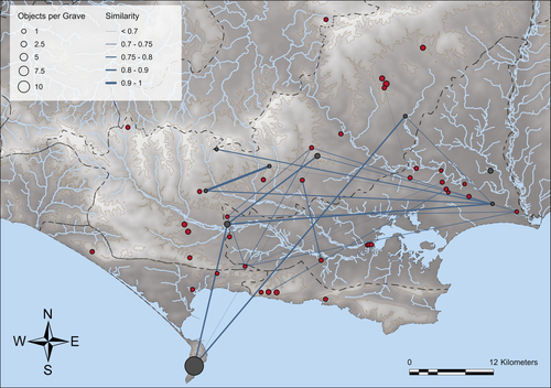
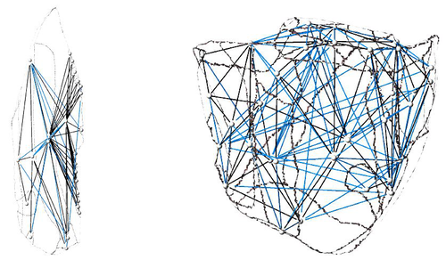
Similarity Network Fusion: Understanding Patterns and their Spatial Significance in Archaeological DatasetsA different approach to similarity networks in Archaeology - Similarity Network FusionRecommended by Joel Santos based on reviews by Matthew Peeples and 1 anonymous reviewerThis is a fascinating paper for anyone interested in network analysis or the chronology and cultures of the case study, namely the Late prehistoric burial sites in Dorset, for which the author’s approach allowed a new perspective over an already deeply studied area [1]. This paper's implementation of Similarity Network Fusion (SNF) is noteworthy. This method is typically utilized within genetic research but has yet to be employed in Archaeology. SNF has the potential to benefit Archaeology due to its unique capabilities and approach significantly. The author exhibits a deep and thorough understanding of previous investigations concerning material and similarity networks while emphasizing the innovative nature of this particular study. The SNF approach intends to improve a lack of the most used (in Archaeology) similarity coefficient, the Brainerd-Robinson, in certain situations, mainly in heterogenous and noisy datasets containing a small number of samples but a large number of measurements, scale differences, and collection biases, among other things. The SNF technique, demonstrated in the case study, effectively incorporates various similarity networks derived from different datatypes into one network. As shown during the Dorset case study, the SNF application has a great application in archaeology, even in already available data, allowing us to go further and bring new visions to the existing interpretations. As stated by the author, SNF shows its potential for other applications and fields in archaeology coping with similar datasets, such as archaeobotany or archaeozoology, and seems to complement different multivariate statistical approaches, such as correspondence or cluster analysis. This paper has been subject to two excellent revisions, which the author mostly accepted. One of the revisions was more technical, improving the article in the metadata part, data availability and clarification, etc. Although the second revision was more conceptual and gave some excellent technical inputs, it focused more on complementary aspects that will allow the paper to reach a wider audience. I vividly recommend its publication. References [1] Geitlinger, T. (2024). Similarity Network Fusion: Understanding Patterns and their Spatial Significance in Archaeological Datasets. Zenodo, 7998239, ver. 3 peer-reviewed and recommended by Peer Community in Archaeology. https://doi.org/10.5281/zenodo.7998239
| Similarity Network Fusion: Understanding Patterns and their Spatial Significance in Archaeological Datasets | Timo Geitlinger | <p>Since its earliest application in the 1970s, network analysis has become increasingly popular in both theoretical and GIS-based archaeology. Yet, applications of material networks remained relatively restricted. This paper describes a specific ... | | Computational archaeology, Protohistory | Joel Santos | 2023-06-02 16:51:19 | ||
08 Apr 2024
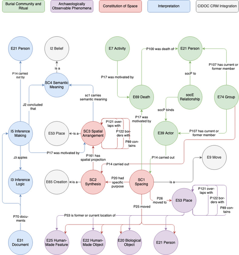
Spaces of funeral meaning. Modelling socio-spatial relations in burial contextsA new approach to a data ontology for the qualitative assessment of funerary spacesRecommended by Asuman Lätzer-Lasar based on reviews by 2 anonymous reviewers
The paper by Aline Deicke [1] is very readable, and it succeeds in presenting a still unnoticed topic in a well-structured way. It addresses the topic of “how to model social-spatial relations in antiquity”, as the title concisely implies, and makes important and interesting points about their interrelationship by drawing on latest theories of sociologists such as Martina Löw combined with digital tools, such as the CIDOC CRM-modeling. The author provides an introductory insight into the research history of funerary archaeology and addresses the problematic issue of not having investigated fully the placement of entities of the grave inventory. So far, the focus of the analysis has been on the composition of the assemblage and not on the positioning within this space-and time-limited context. However, the positioning of the various entities within the burial context also reveals information about the objects themselves, their value and function, as well as about the world view and intentions of the living and dead people involved in the burial. To obtain this form of qualitative data, the author suggests modeling knowledge networks using the CIDOC CRM. The method allows to integrate the spatial turn combined with aspects of the actor-network-theory. The theoretical backbone of the contribution is the fundamental scholarship of Martina Löw’s “Raumsoziologie” (sociology of space), especially two categories of action namely placing and spacing (SC1). The distinction between the two types of action enables an interpretative process that aims for the detection of meaningfulness behind the creation process (deposition process) and the establishment of spatial arrangement (find context). To illustrate with a case study, the author discusses elite burial sites from the Late Urnfield Period covering a region north of the Alps that stretches from the East of France to the entrance of the Carpathian Basin. With the integration of very basic spatial relations, such as “next to”, “above”, “under” and qualitative differentiations, for instance between iron and bronze knives, the author detects specific patterns of relations: bronze knives for food preparing (ritual activities at the burial site), iron knives associated with the body (personal accoutrement). The complexity of the knowledge engineering requires the gathering of several CIDOC CRM extensions, such as CRMgeo, CRMarchaeo, CRMba, CRMinf and finally CRMsoc, the author rightfully suggests. In the end, the author outlines a path that can be used to create this kind of data model as the basis for a graph database, which then enables a further analysis of relationships between the entities in a next step. Since this is only a preliminary outlook, no corrections or alterations are needed. The article is an important step in advancing digital archaeology for qualitative research. References [1] Deicke, A. (2024). Spaces of funeral meaning. Modelling socio-spatial relations in burial contexts. Zenodo, 8310170, ver. 4 peer-reviewed and recommended by Peer Community in Archaeology. https://doi.org/10.5281/zenodo.8310170 | Spaces of funeral meaning. Modelling socio-spatial relations in burial contexts | Aline Deicke | <p>Burials have long been one of the most important sources of archaeology, especially when studying past social practices and structure. Unlike archaeological finds from settlements, objects from graves can be assumed to have been placed there fo... | | Computational archaeology, Protohistory, Spatial analysis, Theoretical archaeology | Asuman Lätzer-Lasar | 2023-09-01 23:15:41 |


