Latest recommendations

| Id | Title | Authors | Abstract | Picture | Thematic fields | Recommender | Reviewers | Submission date | |
|---|---|---|---|---|---|---|---|---|---|
12 Feb 2024
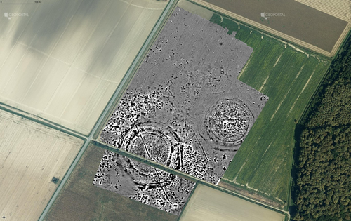
3Duewelsteene - A website for the 3D visualization of the megalithic passage grave Düwelsteene near Heiden in Westphalia, GermanyOnline presentation of the digital reconstruction process of a megalithic tomb : “3Duewelsteene”Recommended by Sophie C. Schmidt and James Allison based on reviews by Robert Bischoff, Ronald Visser and Scott Ure based on reviews by Robert Bischoff, Ronald Visser and Scott Ure
“3Duewelsteene - A website for the 3D visualization of the megalithic passage grave Düwelsteene near Heiden in Westphalia, Germany” (Tharandt 2024) presents several 3-dimensional models of the Düwelsteene monument, along with contextual information about the grave and the process of creating the models. The website (https://3duewelsteene.github.io/) includes English and German versions, making it accessible to a wide audience. The website itself serves as the primary means of presenting the data, rather than as a supplement to a written text. This is an innovative and engaging way to present the research to a wider public. Düwelsteene (“Devil’s Stones”) is a megalithic passage grave from the Funnel Beaker culture, dating to approximately 3300 BC. to 2600 BC. that was excavated in 1932. The website displays three separate 3-dimensional models. They ares shown in the 3D viewer software 3DHOP, which enables viewers to interact with the models in several ways, Annotations on the models display further information. The first model was created by image-based modeling and shows the monument as it appears today. A second model uses historical photographs and excavation data to reconstruct the grave as it appeared prior to the 1932 archaeological excavation. Restoration work following the excavation relocated many of the stones. Pre-1932 photographs collected from residents of the nearby town of Heiden were then used to create a model showing what the tomb looked like before the restoration work. It is commendable that a “certainty view” of the model shows the certainty with which the stones can be put at the reconstructed place. Gaps in the 3D models of stones that were caused by overlap with other stones have been filled with a rough mesh and marked as such, thereby differentiating between known and unknown parts of the stones. The third model is the most imaginative and most interesting. As it shows as the grave as it might have appeared in approximately 3000 B.C., many aspects of this model are necessarily somewhat speculative. There is no direct evidence for exact size and shape of the capstones, the height of the mound, and other details. But enough is known about other similar constructions to allow these details to be inferred with some confidence. Again, care was taken to enable viewers to distinguish between the stones that are still in existence and those that were reconstructed. A video on the home page of the website adds a nice touch. It starts with the model of the Düwelsteene as it currently appears then shows, in reverse order, the changes to the grave, ending with the inferred original state. The 3D reconstructions are convincing and the methods well described. This project follows an open science approach and the FAIR principles, which is commendable and cutting edge in the field of Digital Archaeology. The preprint of the website hosted on zenodo includes all the photos, text, html files, and nine individual 3D model (.ply) files that are combined in the reconstructions exhibited on the website. A “readme.md” file includes details about building the models using CloudCompare and Blender, and modifications to the 3D viewer software (3DHOP) to get the website to improve the display of the reconstructions. We have to note that the link between the reconstructed models and the html page does not work when the files are downloaded from zenodo and opened offline. The html pages open in the browser, and the individual ply files work fine, but the 3D models do not display on the browser page when the html files are opened offline. The online version of the website is working perfectly. The 3Düwelsteene website combines the presentation of archaeological domain knowledge to a lay audience as well as in-depths information on the reconstruction process to make it an interesting contribution for researchers. By providing data and code for the website it also models an Open Science approach, which enables other researchers to re-use these materials. We congratulate the author on a successful reconstruction of the megalithic tomb, an admirable presentation of the archaeological work and the thoughtful outreach to a broad audience. Bibliography | 3Duewelsteene - A website for the 3D visualization of the megalithic passage grave Düwelsteene near Heiden in Westphalia, Germany | Tharandt, Louise | <p>The Düwelsteene near Heiden, Westphalia, is one of the most southern megalithic tombs of the Funnel Beaker culture. In 1932 the Düwelsteene were restored and the appearance of the grave was changed. Even though the megalithic tomb was excavated... | | Computational archaeology, Mesolithic, Neolithic | Sophie C. Schmidt | 2023-05-21 17:24:22 | ||
12 Feb 2024
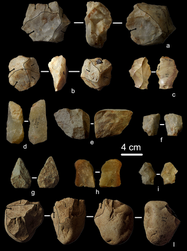
First evidence of a Palaeolithic occupation of the Po plain in Piedmont: the case of Trino (north-western Italy)Not Simply the Surface: Manifesting Meaning in What Lies Above.Recommended by Marcel Kornfeld based on reviews by Lawrence Todd, Jason LaBelle and 2 anonymous reviewersThe archaeological record comes in many forms. Some, such as buried sites from volcanic eruptions or other abrupt sedimentary phenomena are perhaps the only ones that leave relatively clean snapshots of moments in the past. And even in those cases time is compressed. Much, if not all other archaeological record is a messy affair. Things, whatever those things may be, artifacts or construction works (i.e., features), moved, modified, destroyed, warped and in a myriad of ways modified from their behavioral contexts. Do we at some point say the record is worthless? Not worth the effort or continuing investigation. Perhaps sometimes this may be justified, but as Daffara and colleagues show, heavily impacted archaeological remains can give us clues and important information about the past. Thoughtful and careful prehistorians can make significant contributions from what appear to be poor archaeological records. In the case of Daffara and colleagues, a number of important theoretical cross-sections can be recognized. For a long time surface archaeology was thought of simply as a way of getting a preliminary peak at the subsurface. From some of the earliest professional archaeologists (e.g., Kidder 1924, 1931; Nelson 1916) to the New Archaeologists of the 1960s, the link between the surface and subsurface was only improved in precision and systematization (Binford et al. 1970). However, at Hatchery West Binford and colleagues not only showed that surface material can be used more reliably to get at the subsurface, but that substantive behavioral inferences can be made with the archaeological record visible on the surface. Much more important are the behavioral implications drawn from surface material. I am not sure we can cite the first attempts at interpreting prehistory from the surface manifestations of the archaeological record, but a flurry of such approaches proliferated in the 1970s and beyond (Dunnell and Dancey 1983; Ebert 1992; Foley 1981). Off-site archaeology, non-site archaeology, later morphing into landscape archaeology all deal strictly with surface archaeological record to aid in understanding the past. With the current paper, Daffara and colleagues (2024) are clearly in this camp. Although still not widely accepted, it is clear that some behaviors (parts of systems) can only be approached from surface archaeological record. It is very unlikely that a future archaeologist will be able to excavate an entire human social/cultural system; people moving from season to season, creating multiple long and short term camps, travelling, procuring resources, etc. To excavate an entire system one would need to excavate 20,000 km2 or some similarly impossible task. Even if it was physically possible to excavate such an enormous area, it is very likely that some of contextual elements of any such system will be surface manifestations. Without belaboring the point, surface archaeological record yields data like any other archaeological record. We must contextual the archaeological artifacts or features weather they come from surface or below. Daffara and colleagues show us that we can learn about deep prehistory of northern Italy, with collections that were unsystematically collected, biased by agricultural as well as other land deformations agents. They carefully describe the regional prehistory as we know it, in particular specific well documented sites and assemblages as a means of applying such knowledge to less well controlled or uncontrolled collections.
References Binford, L., Binford, R. S. R., Whallon, R. and Hardin, M. A. (1970). Archaeology of Hatchery West. Memoirs of the Society for American Archaeology, No. 24, Washington D.C. Daffara, S., Giraudi, C., Berruti, G. L. F., Caracausi, S. and Garanzini, F. (2024). First evidence of a Palaeolithic frequentation of the Po plain in Piedmont: the case of Trino (north-western Italy), OSF Preprints, pz4uf, ver. 6 peer-reviewed and recommended by Peer Community in Archaeology. https://doi.org/10.31219/osf.io/pz4uf Dunnell, R. C. and Dancey, W. S. (1983). The siteless survey: a regional scale data collection strategy. In Advances in Archaeological Method and Theory, vol. 6, edited by Michael B. Schiffer, pp. 267-287. Academic Press, New York. Ebert, J. I. (1992). Distributional Archaeology. University of New Mexico Press, Albuquerque. Foley, R. A. (1981). Off site archaeology and human adaptation in eastern Africa: An analysis of regional artefact density in the Amboseli, Southern Kenya. British Archaeological Reports International Series 97. Cambridge Monographs in African Archaeology 3. Oxford England. Kidder, A. V. (1924). An Introduction to the Study of Southwestern Archaeology, With a Preliminary Account of the Excavations at Pecos. Papers of the Southwestern Expedition, Phillips Academy, no. 1. New Haven, Connecticut. Kidder, A. V. (1931). The Pottery of Pecos, vol. 1. Papers of the Southwestern Expedition, Phillips Academy. New Haven, Connecticut. Nelson, N. (1916). Chronology of the Tano Ruins, New Mexico. American Anthropologist 18(2):159-180. | First evidence of a Palaeolithic occupation of the Po plain in Piedmont: the case of Trino (north-western Italy) | Sara Daffara, Carlo Giraudi, Gabriele L.F. Berruti, Sandro Caracausi, Francesca Garanzini | <p>The Trino hill is an isolated relief located in north-western Italy, close to Trino municipality. The hill was subject of multidisciplinary studies during the 1970s, when, because of quarrying and agricultural activities, five concentrations of... | | Lithic technology, Middle Palaeolithic | Marcel Kornfeld | 2023-10-04 16:58:19 | ||
08 Feb 2024
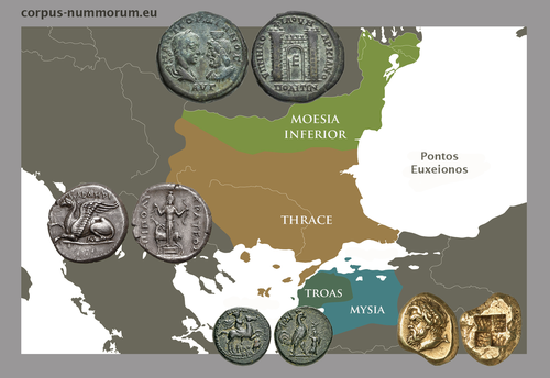
CORPUS NUMMORUM – A Digital Research Infrastructure for Ancient CoinsThe valuable Corpus Nummorum: a not so Little MinionRecommended by Ronald Visser based on reviews by Fleur Kemmers and 1 anonymous reviewer
The paper under review/recommendation deals with Corpus Nummorum (Peter et al. 2024). The Corpus Nummorum (CN) is web portal for ancient Greek coins from various collections (https://www.corpus-nummorum.eu/). The CN is a database and research tool for Greek coins dating between 600 BCE to 300 CE. While many traditional collection databases aim at collecting coins, CN also includes coin dies, coin types and issues. It aims at achieving a complete online coin type catalogue. The paper is not a paper in a traditional sense, but presents the CN as a tool and shows the functionalities in the system. The relevance and the possibilities of the CN for numismatists is made clear in the paper and the merits are clear even for me as a Roman archaeologist and non-numismatist. The CN was presented as a poster at the CAA 2023 in Amsterdam during “S03. Our Little Minions pt. V: small tools with major impact”, organized by Moritz Mennenga, Florian Thiery, Brigit Danthine and myself (Mennenga et al. 2023). Little Minions help us significantly in our daily work as small self-made scripts, home-grown small applications and small hardware devices. They often reduce our workload or optimize our workflows, but are generally under-represented during conferences and not often presented to the outside world. Therefore, the Little Minions form a platform that enables researchers and software engineers to share these tools (Thiery, Visser and Mennenga 2021). Little Minions have become a well known happening within the CAA-community since we started this in 2018, also because we do not only allow 10-minute lightning talks, but also spontaneous stand-up presentations during the conference. A full list of all minions presented in the past, can be found online: https://caa-minions.github.io/minions/. In a strict sense the CN would not count as a Little Minion, because it is a large project consisting of many minions that help a numismatist in his/her daily work. The CN seems a very Big Minion in that sense. Personally, I am very happy to see the database being developed as a fully open system and that code can be found on Github (https://github.com/telota/corpus-nummorum-editor), and also made citable with citation information in GitHub (see https://citation-file-format.github.io/) and a version deposited in Zenodo with DOI (Köster and Franke 2024). In addition, the authors claim that the CN will be shared based on the FAIR-principles (Wilkinson et al. 2016, 2019). These guidelines are developed to improve the Findability, Accessibility, Interoperability, and Reuse of digital data. I feel that CN will be a way forward in open numismatics and open archaeology. The CN is well known within the numismatist community and it was hard to find reviewers in this close community, because many potential reviewers work together with one or more of the authors, or are involved in the project. This also proves the relevance of the CN to the research community and beyond. Luckily, a Roman numismatist and a specialist in digital/computational archaeology were able to provide valuable feedback on the current paper. The reviewers only submitted feedback on the first version of the paper (Peter et al. 2023). The numismatist was positive on the content and the usefulness of CN for the discipline in general. However, she pointed out some important points that need to be addressed. The digital specialist was positive is various aspects, but also raised some important issues in relation to technical aspects and the explanation thereof. While both were positive on the project and the paper in general, both reviewers pointed out some issues that were largely addressed in the second version of this paper. The revised version was edited throughout and the paper was strongly improved. The Corpus Nummorum is well presented in this easy to read paper, although the explanations can sometimes be slightly technical. This paper gives a good introduction to the CN and I recommend this for publication. I sincerely hope that the CN will contribute and keep on contributing to the domains of numismatics, (digital) archaeology and open science in general. References Köster, J and Franke, C. 2024 Corpus Nummorum Editor. https://doi.org/10.5281/zenodo.10458195 Mennenga, M, Visser, RM, Thiery, F and Danthine, B. 2023 S03. Our Little Minions pt. V: small tools with major impact. In:. Book of Abstracts. CAA 2023: 50 Years of Synergy. Amsterdam: Zenodo. pp. 249–251. https://doi.org/10.5281/ZENODO.7930991 Peter, U, Franke, C, Köster, J, Tolle, K, Gampe, S and Stolba, VF. 2023 CORPUS NUMMORUM – A Digital Research Infrastructure for Ancient Coins. https://doi.org/10.5281/ZENODO.8263518 Peter, U., Franke, C., Köster, J., Tolle, K., Gampe, S. and Stolba, V. F. (2024). CORPUS NUMMORUM – A Digital Research Infrastructure for Ancient Coins, Zenodo, 8263517, ver. 3 peer-reviewed and recommended by Peer Community in Archaeology. https://doi.org/10.5281/zenodo.8263517 Thiery, F, Visser, RM and Mennenga, M. 2021 Little Minions in Archaeology An open space for RSE software and small scripts in digital archaeology. https://doi.org/10.5281/ZENODO.4575167 Wilkinson, MD, Dumontier, M, Aalbersberg, IjJ, Appleton, G, Axton, M, Baak, A, Blomberg, N, Boiten, J-W, da Silva Santos, LB, Bourne, PE, Bouwman, J, Brookes, AJ, Clark, T, Crosas, M, Dillo, I, Dumon, O, Edmunds, S, Evelo, CT, Finkers, R, Gonzalez-Beltran, A, Gray, AJG, Groth, P, Goble, C, Grethe, JS, Heringa, J, ’t Hoen, PAC, Hooft, R, Kuhn, T, Kok, R, Kok, J, Lusher, SJ, Martone, ME, Mons, A, Packer, AL, Persson, B, Rocca-Serra, P, Roos, M, van Schaik, R, Sansone, S-A, Schultes, E, Sengstag, T, Slater, T, Strawn, G, Swertz, MA, Thompson, M, van der Lei, J, van Mulligen, E, Velterop, J, Waagmeester, A, Wittenburg, P, Wolstencroft, K, Zhao, J and Mons, B. 2016 The FAIR Guiding Principles for scientific data management and stewardship. Scientific Data 3(1): 160018. https://doi.org/10.1038/sdata.2016.18 Wilkinson, MD, Dumontier, M, Jan Aalbersberg, I, Appleton, G, Axton, M, Baak, A, Blomberg, N, Boiten, J-W, da Silva Santos, LB, Bourne, PE, Bouwman, J, Brookes, AJ, Clark, T, Crosas, M, Dillo, I, Dumon, O, Edmunds, S, Evelo, CT, Finkers, R, Gonzalez-Beltran, A, Gray, AJG, Groth, P, Goble, C, Grethe, JS, Heringa, J, Hoen, PAC ’t, Hooft, R, Kuhn, T, Kok, R, Kok, J, Lusher, SJ, Martone, ME, Mons, A, Packer, AL, Persson, B, Rocca-Serra, P, Roos, M, van Schaik, R, Sansone, S-A, Schultes, E, Sengstag, T, Slater, T, Strawn, G, Swertz, MA, Thompson, M, van der Lei, J, van Mulligen, E, Jan Velterop, Waagmeester, A, Wittenburg, P, Wolstencroft, K, Zhao, J and Mons, B. 2019 Addendum: The FAIR Guiding Principles for scientific data management and stewardship. Scientific Data 6(1): 6. https://doi.org/10.1038/s41597-019-0009-6 | CORPUS NUMMORUM – A Digital Research Infrastructure for Ancient Coins | Ulrike Peter, Claus Franke, Jan Köster, Karsten Tolle, Sebastian Gampe, Vladimir F. Stolba | <p>CORPUS NUMMORUM indexes ancient Greek coins from various landscapes and develops typologies. The coins and coin types are published on the multilingual website www.corpus-nummorum.eu utilizing numismatic authority data and adhering to FAIR prin... | | Antiquity, Classic | Ronald Visser | 2023-08-18 17:37:51 | ||
03 Feb 2024
Digital surface models of crops used in archaeological feature detection – a case study of Late Neolithic site Tomašanci-Dubrava in Eastern CroatiaWhat lies on top lies also beneath? Connecting crop surface modelling to buried archaeology mapping.Recommended by Markos Katsianis based on reviews by Ian Moffat and Geert Verhoeven
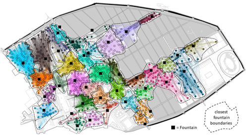
This paper (Sosic et al. 2024) explores the Neolithic landscape of the Sopot culture in Đakovština, Eastern Slavonija, revealing a network of settlements through a multi-faceted approach that combines aerial archaeology, magnetometry, excavation, and field survey. This strategy facilitates scalable research tailored to the particularities of each site and allows for improved representations of buried archaeology with minimal intrusion. Using the site of Tomašanci-Dubrava as an example of the overall approach, the study further explores the use of drone imagery for 3D surface modeling, revealing a consistent correlation between crop surface elevation during full plant growth and ground terrain after ploughing, attributed to subsurface archaeological features. Results are correlated with magnetic survey and test-pitting data to validate the micro-topography and clarify the relationship between different subsurface structures. The results obtained are presented in a comprehensive way, including their source data, and are contextualized in relation to conventional cropmark detection approaches and expectations. I found this aspect very interesting, since the crop surface and terrain models contradict typical or textbook examples of cropmark detection, where the vegetation is projected to appear higher in ditches and lower in areas with buried archaeology (Renfrew & Bahn 2016, 82). Regardless, the findings suggest the potential for broader applications of crop surface or canopy height modelling in landscape wide surveys, utilizing ALS data or aerial photographs. It seems then that the authors make a valid argument for a layered approach in landscape-based site detection, where aerial imagery can be used to accurately map the topography of areas of interest, which can then be further examined at site scale using more demanding methods, such as geophysical survey and excavation. This scalability enhances the research's relevance in broader archaeological and geographical contexts and renders it a useful example in site detection and landscape-scale mapping. References Renfrew, C. and Bahn, P. (2016). Archaeology: theories, methods and practice. Thames and Hudson. Sosic Klindzic, R., Vuković, M., Kalafatić, H. and Šiljeg, B. (2024). Digital surface models of crops used in archaeological feature detection – a case study of Late Neolithic site Tomašanci-Dubrava in Eastern Croatia, Zenodo, 7970703, ver. 4 peer-reviewed and recommended by Peer Community in Archaeology. https://doi.org/10.5281/zenodo.7970703 | Digital surface models of crops used in archaeological feature detection – a case study of Late Neolithic site Tomašanci-Dubrava in Eastern Croatia | Sosic Klindzic Rajna; Vuković Miroslav; Kalafatić Hrvoje; Šiljeg Bartul | <p>This paper presents the results of a study on the neolithic landscape of the Sopot culture in the area of Đakovština in Eastern Slavonija. A vast network of settlements was uncovered using aerial archaeology, which was further confirmed and chr... | | Landscape archaeology, Neolithic, Remote sensing, Spatial analysis | Markos Katsianis | 2023-09-01 12:57:04 | ||
02 Feb 2024
Implementing Digital Documentation Techniques for Archaeological Artifacts to Develop a Virtual Exhibition: the Necropolis of Baley CollectionOut of the storeroom and into the virtualRecommended by Jitte Waagen based on reviews by Alicia Walsh and 1 anonymous reviewer
This paper (Raykovska et al. 2023) discusses the digital documentation techniques and development of a virtual exhibition for artefacts retrieved from the necropolis of Baley, Bulgaria. The principal aim of this particular project is a solid one, trying to provide a solution to display artefacts that would otherwise remain hidden in museum storerooms. The paper describes how through a combination of 3D scanning and photogrammetry high quality 3D models have been produced, and provide content for an online virtual exhibition for the scientific community but also the larger public. It is a well-written and concise paper, in which the information on developed methods and techniques are transparently described, and various important aspects of digitization workflows, such as the importance of storing raw data, are addressed. The paper is a timely discussion on this subject, as strategies to develop digital artefact collections and what to do with those are increasingly being researched. Specifically, it discusses a workflow and its results, both in great detail. Although critical reflection on the process, goals and results from various perspectives would have been a valuable addition to the paper (cf., Jeffra 2020, Paardekoper 2019), it nonetheless provides a good practice example of how to approach the creation of a virtual museum. Those who consider projects concerning digital documentation of archaeological artefacts as well as the creation of virtual spaces to use those in for research, education or valorisation purposes would do well to read this paper carefully. References Jeffra, C., Hilditch, J., Waagen, J., Lanjouw, T., Stoffer, M., de Gelder, L., and Kim, M. J. (2020). Blending the Material and the Digital: A Project at the Intersection of Museum Interpretation, Academic Research, and Experimental Archaeology. The EXARC Journal, 2020(4). https://exarc.net/ark:/88735/10541 Paardekooper, R.P. (2019). Everybody else is doing it, so why can’t we? Low-tech and High-tech approaches in archaeological Open-Air Museums. The EXARC Journal, 2019(4). https://exarc.net/ark:/88735/10457/ Raykovska, M., Jones, K., Klecherova, H., Alexandrov, S., Petkov, N., Hristova, T., and Ivanov, G. (2023). Implementing Digital Documentation Techniques for Archaeological Artifacts to Develop a Virtual Exhibition: the Necropolis of Baley Collection. https://doi.org/10.5281/zenodo.10091870 | Implementing Digital Documentation Techniques for Archaeological Artifacts to Develop a Virtual Exhibition: the Necropolis of Baley Collection | Raykovska Miglena, Jones Kristen, Klecherova Hristina, Alexandrov Stefan, Petkov Nikolay, Hristova Tanya, Ivanov Georgi | <p>Over the past decade, virtual reality has been quickly growing in popularity across disciplines including the field of archaeology and cultural heritage. Despite numerous artifacts being uncovered each year by archaeological excavations around ... | | Ceramics, Computational archaeology, Conservation/Museum studies | Jitte Waagen | 2023-06-12 14:02:44 | ||
31 Jan 2024
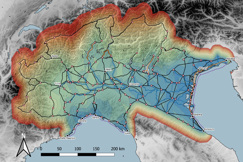
Rivers vs. Roads? A route network model of transport infrastructure in Northern Italy during the Roman periodModelling Roman Transport Infrastructure in Northern ItalyRecommended by Andrew McLean based on reviews by Pau de Soto and Adam PažoutStudies of the economy of the Roman Empire have become increasingly interdisciplinary and nuanced in recent years, allowing the discipline to make great strides in data collection and importantly in the methods through which this increasing volume of data can be effectively and meaningfully analysed [see for example 1 and 2]. One of the key aspects of modelling the ancient economy is understanding movement and transport costs, and how these facilitated trade, communication and economic development. With archaeologists adopting more computational techniques and utilising GIS analysis beyond simply creating maps for simple visualisation, understanding and modelling the costs of traversing archaeological landscapes has become a much more fruitful avenue of research. Classical archaeologists are often slower to adopt these new computational techniques than others in the discipline. This is despite (or perhaps due to) the huge wealth of data available and the long period of time over which the Roman economy developed, thrived and evolved. This all means that the Roman Empire is a particularly useful proving ground for testing and perfecting new methodological developments, as well as being a particularly informative period of study for understanding ancient human behaviour more broadly. This paper by Page [3] then, is well placed and part of a much needed and growing trend of Roman archaeologists adopting these computational approaches in their research. Page’s methodology builds upon De Soto’s earlier modelling of transport costs [4] and applies it in a new setting. This reflects an important practice which should be more widely adopted in archaeology. That of using existing, well documented methodologies in new contexts to offer wider comparisons. This allows existing methodologies to be perfected and tested more robustly without reinventing the wheel. Page does all this well, and not only builds upon De Soto’s work, but does so using a case study that is particularly interesting with convincing and significant results. As Page highlights, Northern Italy is often thought of as relatively isolated in terms of economic exchange and transport, largely due to the distance from the sea and the barriers posed by the Alps and Apennines. However, in analysing this region, and not taking such presumptions for granted, Page quite convincingly shows that the waterways of the region played an important role in bringing down the cost of transport and allowed the region to be far more interconnected with the wider Roman world than previous studies have assumed. This article is clearly a valuable and important contribution to our understanding of computational methods in archaeology as well as the economy and transport network of the Roman Empire. The article utilises innovative techniques to model transport in an area of the Roman Empire that is often overlooked, with the economic isolation of the area taken for granted. Having high quality research such as this specifically analysing the region using the most current methodologies is of great importance. Furthermore, developing and improving methodologies like this allow for different regions and case studies to be analysed and directly compared, in a way that more traditional analyses simply cannot do. As such, Page has demonstrated the importance of reanalysing traditional assumptions using the new data and analyses now available to archaeologists. References [1] Brughmans, T. and Wilson, A. (eds.) (2022). Simulating Roman Economies: Theories, Methods, and Computational Models. Oxford. [2] Dodd, E.K. and Van Limbergen, D. (eds.) (2024). Methods in Ancient Wine Archaeology: Scientific Approaches in Roman Contexts. London ; New York. [3] Page, J. (2024). Rivers vs. Roads? A route network model of transport infrastructure in Northern Italy during the Roman period, Zenodo, 7971399, ver. 3 peer-reviewed and recommended by Peer Community in Archaeology. https://doi.org/10.5281/zenodo.7971399 [4] De Soto P (2019). Network Analysis to Model and Analyse Roman Transport and Mobility. In: Finding the Limits of the Limes. Modelling Demography, Economy and Transport on the Edge of the Roman Empire. Ed. by Verhagen P, Joyce J, and Groenhuijzen M. Springer Open Access, pp. 271–90. https://doi.org/10.1007/978-3-030-04576-0_13 | Rivers vs. Roads? A route network model of transport infrastructure in Northern Italy during the Roman period | James Page | <p>Northern Italy has often been characterised as an isolated and marginal area during the Roman period, a region constricted by mountain ranges and its distance from major shipping lanes. Historians have frequently cited these obstacles, alongsid... | | Classic, Computational archaeology | Andrew McLean | 2023-05-28 15:11:31 | ||
29 Jan 2024
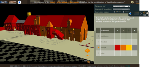
Visual encoding of a 3D virtual reconstruction's scientific justification: feedback from a proof-of-concept research3D Models, Knowledge and Visualization: a prototype for 3D virtual models according to plausible criteriaRecommended by Daniel Carvalho based on reviews by Robert Bischoff and Louise TharandtThe construction of 3D realities is deeply embedded in archaeological practices. From sites to artifacts, archaeology has dedicated itself to creating digital copies for the most varied purposes. The paper “Visual encoding of a 3D virtual reconstruction's 3 scientific justification: feedback from a proof-of-concept research” (Jean-Yves et al 2024) represents an advance, in the sense that it does not just deal with a three-dimensional theory for archaeological practice, but rather offers proposals regarding the epistemic component, how it is possible to represent knowledge through the workflow of 3D virtual reconstructions themselves. The authors aim to unite three main axes - knowledge modeling, visual encoding and 3D content reuse - (Jean-Yves et al 2024: 2), which, for all intents and purposes, form the basis of this article. With regard to the first aspect, this work questions how it is possible to transmit the knowledge we want to a 3D model and how we can optimize this epistemic component. A methodology based on plausibility criteria is offered, which, for the archaeological field, offers relevant space for reflection. Given our inability to fully understand the object or site that is the subject of the 3D representation, whether in space or time, building a method based on probabilistic categories is probably one of the most realistic approaches to the realities of the past. Thus, establishing a plausibility criterion allows the user to question the knowledge that is transmitted through the representation, and can corroborate or refute it in future situations. This is because the role of reusing these models is of great interest to the authors, a perfectly justifiable sentiment, as it encourages a critical view of scientific practices. Visual encoding is, in terms of its conjunction with knowledge practices, a key element. The notion of simplicity under Maeda's (2006) design principles not only represents a way of thinking that favors operability, but also a user-friendly design in the prototype that the authors have created. This is also visible when it comes to the reuse of parts of the models, in a chronological logic: adapting the models based on architectural elements that can be removed or molded is a testament to intelligent design, whereby instead of redoing models in their entirety, they are partially used for other purposes. All these factors come together in the final prototype, a web application that combines relational databases (RDBMS) with a data mapper (MassiveJS), using the PHP programming language. The example used is the Marmoutier Abbey hostelry, a centuries-old building which, according to the sources presented, has evolved architecturally over several centuries ((Jean-Yves et al 2024: 8). These states of the building are represented visually through architectural elements based on their existence, location, shape and size, always in terms of what is presented as being plausible. This allows not only the creation of a matrix in which various categories are related to various architectural elements, but also a visual aid, through a chromatic spectrum, of the plausibility that the authors are aiming for. In short, this is an article that seeks to rethink the degree of knowledge we can obtain through 3D visualizations and that does not take models as static, but rather realities that must be explored, recycled and reinterpreted in the light of different data, users and future research. For this reason, it is a work of great relevance to theoretical advances in 3D modeling adapted to archaeology.
References Blaise, J.-Y., Dudek, I., Bergerot, L. and Gaël, S. (2024). Visual encoding of a 3D virtual reconstruction's scientific justification: feedback from a proof-of-concept research, Zenodo, 7983163, ver. 3 peer-reviewed and recommended by Peer Community in Archaeology. https://doi.org/10.5281/zenodo.10496540 John Maeda. (2006). The Laws of Simplicity. MIT Press, Cambridge, MA, USA. | Visual encoding of a 3D virtual reconstruction's scientific justification: feedback from a proof-of-concept research | J.Y Blaise, I.Dudek, L.Bergerot, G.Simon | <p> 3D virtual reconstructions have become over the last decades a classical mean to communicate about analysts’ visions concerning past stages of development of an edifice or a site. However, they still today remain quite often a one-s... | | Computational archaeology, Spatial analysis | Daniel Carvalho | 2023-05-30 00:43:03 | ||
24 Jan 2024
Social Network Analysis, Community Detection Algorithms, and Neighbourhood Identification in PompeiiA Valuable Contribution to Archaeological Network Research: A Case Study of PompeiiRecommended by David Laguna-Palma based on reviews by Matthew Peeples, Isaac Ullah and Philip Verhagen
The paper entitled 'Social Network Analysis, Community Detection Algorithms, and Neighbourhood Identification in Pompeii' [1] presents a significant contribution to the field of archaeological network research, particularly in the challenging task of identifying urban neighborhoods within the context of Pompeii. This study focuses on the relational dynamics within urban neighborhoods and examines their indistinct boundaries through advanced analytical methods. The methodology employed provides a comprehensive analysis of community detection, including the Louvain and Leiden algorithms, and introduces a novel Convex Hull of Admissible Modularity Partitions (CHAMP) algorithm. The incorporation of a network approach into this domain is both innovative and timely. The potential impact of this research is substantial, offering new perspectives and analytical tools. This opens new avenues for understanding social structures in ancient urban settings, which can be applied to other archaeological contexts beyond Pompeii. Moreover, the manuscript is not only methodologically solid but also well-written and structured, making complex concepts accessible to a broad audience. In conclusion, this study represents a valuable contribution to the field of archaeology, particularly for archaeological network research. Their results not only enhance our knowledge of Pompeii but also provide a robust framework for future studies in similar historical contexts. Therefore, this publication advances our understanding of social dynamics in historical urban environments. The rigorous analysis, combined with the innovative application of network algorithms, makes this study a noteworthy addition to the existing body of network science literature. It is recommended for a wide range of scholars interested in the intersection of archaeology, history, and network science. Reference [1] Notarian, Matthew. 2024. Social Network Analysis, Community Detection Algorithms, and Neighbourhood Identification in Pompeii. https://doi.org/10.5281/zenodo.8305968 | Social Network Analysis, Community Detection Algorithms, and Neighbourhood Identification in Pompeii | Notarian, Matthew | <p>The definition and identification of urban neighbourhoods in archaeological contexts remain complex and problematic, both theoretically and empirically. As constructs with both social and spatial characteristics, their detection through materia... | | Antiquity, Classic, Computational archaeology, Mediterranean | David Laguna-Palma | 2023-08-31 19:28:35 | ||
13 Jan 2024
Dealing with post-excavation data: the Omeka S TiMMA web-databaseManaging Archaeological Data with Omeka SRecommended by Jonathan Hanna based on reviews by Electra Tsaknaki and 1 anonymous reviewer
Managing data in archaeology is a perennial problem. As the adage goes, every day in the field equates to several days in the lab (and beyond). For better or worse, past archaeologists did all their organizing and synthesis manually, by hand, but since the 1970s ways of digitizing data for long term management and analysis have gained increasing attention [1]. It is debatable whether this ever actually made things easier, particularly given the associated problem of sustainable maintenance and accessibility of the data. Many older archaeologists, for instance, still have reels and tapes full of data that now require a new form of archaeology to excavate (see [2] for an unrealized idea on how to solve this). Today, the options for managing digital archaeological data are limited only by one’s imagination. There are systems built specifically for archaeology, such as Arches [3], Ark [4], Codifi [5], Heurist [6], InTerris Registries [7], OpenAtlas [8], S-Archeo [9], and Wild Note [10], as well as those geared towards museum collections like PastPerfect [11] and CatalogIt [12], among others. There are also mainstream databases that can be adapted to archaeological needs like MS Access [13] and Claris FileMaker [14], as well as various web database apps that function in much the same way (e.g., Caspio [15], dbBee [16], Amazon's Simpledb [17], Sci-Note [18], etc.) — all with their own limitations in size, price, and utility. One could also write the code for specific database needs using pre-built frameworks like those in Ruby-On-Rails [19] or similar languages. And of course, recent advances in machine-learning and AI will undoubtedly bring new solutions in the near future. But let’s be honest — most archaeologists probably just use Excel. That's partly because, given all the options, it is hard to decide the best tool and whether its worth changing from your current system, especially given few real-world examples in the literature. Bastien Rueff’s new paper [20] is therefore a welcomed presentation on the use of Omeka S [21] to manage data collected for the Timbers in Minoan and Mycenaean Architecture (TiMMA) project. Omeka S is an open-source web-database that is based in PHP and MySQL, and although it was built with the goal of connecting digital cultural heritage collections with other resources online, it has been rarely used in archaeology. Part of the issue is that Omeka Classic was built for use on individual sites, but this has now been scaled-up in Omeka S to accommodate a plurality of sites. Some of the strengths of Omeka S include its open-source availability (accessible regardless of budget), the way it links data stored elsewhere on the web (keeping the database itself lean), its ability to import data from common file types, and its multi-lingual support. The latter feature was particularly important to the TiMAA project because it allowed members of the team (ranging from English, Greek, French, and Italian, among others) to enter data into the system in whatever language they felt most comfortable. However, there are several limitations specific to Omeka S that will limit widespread adoption. Among these, Omeka S apparently lacks the ability to export metadata, auto-fill forms, produce summations or reports, or provide basic statistical analysis. Its internal search capabilities also appear extremely limited. And that is not to mention the barriers typical of any new software, such as onerous technical training, questionable long-term sustainability, or the need for the initial digitization and formatting of data. But given the rather restricted use-case for Omeka S, it appears that this is not a comprehensive tool but one merely for data entry and storage that requires complementary software to carry out common tasks. As such, Rueff has provided a review of a program that most archaeologists will likely not want or need. But if one was considering adopting Omeka S for a project, then this paper offers critical information for how to go about that. It is a thorough overview of the software package and offers an excellent example of its use in archaeological practice.
[1] Doran, J. E., and F. R. Hodson (1975) Mathematics and Computers in Archaeology. Harvard University Press. [2] Snow, Dean R., Mark Gahegan, C. Lee Giles, Kenneth G. Hirth, George R. Milner, Prasenjit Mitra, and James Z. Wang (2006) Cybertools and Archaeology. Science 311(5763):958–959. [3] https://www.archesproject.org/ [4] https://ark.lparchaeology.com/ [5] https://codifi.com/ [6] https://heuristnetwork.org/ [7] https://www.interrisreg.org/ [8] https://openatlas.eu/ [9] https://www.skinsoft-lab.com/software/archaelogy-collection-management [10] https://wildnoteapp.com/ [11] https://museumsoftware.com/ [12] https://www.catalogit.app/ [13] https://www.microsoft.com/en-us/microsoft-365/access [14] https://www.claris.com/filemaker/ [15] https://www.caspio.com/ [16] https://www.dbbee.com/ [17] https://aws.amazon.com/simpledb/ [18] https://www.scinote.net/ [19] https://rubyonrails.org/ [20] Rueff, Bastien (2023) Dealing with Post-Excavation Data: The Omeka S TiMMA Web-Database. peer-reviewed and recommended by Peer Community in Archaeology. https://zenodo.org/records/7989905 [21] https://omeka.org/
| Dealing with post-excavation data: the Omeka S TiMMA web-database | Bastien Rueff | <p>This paper reports on the creation and use of a web database designed as part of the TiMMA project with the Content Management System Omeka S. Rather than resulting in a technical manual, its goal is to analyze the relevance of using Omeka S in... | | Buildings archaeology, Computational archaeology | Jonathan Hanna | 2023-05-31 12:16:25 | ||
10 Jan 2024
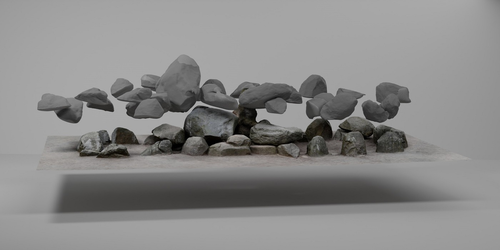
Linking Scars: Topology-based Scar Detection and Graph Modeling of Paleolithic Artifacts in 3DA valuable contribution to automated analysis of palaeolithic artefactsRecommended by Sebastian Hageneuer based on reviews by Lutz Schubert and 1 anonymous reviewer
In this paper (Linsel/Bullenkamp/Mara 2024), the authors propose an automatic system for scar-ridge-pattern detection on palaeolithic artefacts based on Morse Theory. Scare-Ridge pattern recognition is a process that is usually done manually while creating a drawing of the object itself. Automatic systems to detect scars or ridges exist, but only a small amount of them is utilizing 3D data. In addition to the scar-ridges detection, the authors also experiment in automatically detecting the operational sequence, the temporal relation between scars and ridges. As a result, they can export a traditional drawing as well as graph models displaying the relationships between the scars and ridges. After an introduction to the project and the practice of documenting palaeolithic artefacts, the authors explain their procedure in automatising the analysis of scars and ridges as well as their temporal relation to each other on these artefacts. To illustrate the process, an open dataset of lithic artefacts from the Grotta di Fumane, Italy, was used and 62 artefacts selected. To establish a Ground Truth, the artefacts were first annotated manually. The authors then continue to explain in detail each step of the automated process that follows and the results obtained. In the second part of the paper, the results are presented. First the results of the segmentation process shows that the average percentage of correctly labelled vertices is over 91%, which is a remarkable result. The graph modelling however shows some more difficulties, which the authors are aware of. To enhance the process, the authors rightfully aim to include datasets of experimental archaeology in the future. They also aim to develop a way of detecting the operational sequence automatically and precisely. This paper has great potential as it showcases exactly what Digital and Computational Archaeology is about: The development of new digital methods to enhance the analysis of archaeological data. While this procedure is still in development, the authors were able to present a valuable contribution to the automatization of analytical archaeology. By creating a step towards the machine-readability of this data, they also open up the way to further steps in machine learning within Archaeology. BibliographyLinsel, F., Bullenkamp, J. P., and Mara, H. (2024). Linking Scars: Topology-based Scar Detection and Graph Modeling of Paleolithic Artifacts in 3D, Zenodo, 8296269, ver. 3 peer-reviewed and recommended by Peer Community in Archaeology. https://doi.org/10.5281/zenodo.8296269 | Linking Scars: Topology-based Scar Detection and Graph Modeling of Paleolithic Artifacts in 3D | Florian Linsel, Jan Philipp Bullenkamp & Hubert Mara | <p>Motivated by the concept of combining the archaeological practice of creating lithic artifact drawings with the potential of 3D mesh data, our goal in this project is not only to analyze the shape at the artifact level, but also to enable a mor... | | Computational archaeology, Europe, Lithic technology, Upper Palaeolithic | Sebastian Hageneuer | 2023-09-01 23:03:59 |


