Latest recommendations

| Id | Title * | Authors * | Abstract * ▲ | Picture * | Thematic fields * | Recommender | Reviewers | Submission date | |
|---|---|---|---|---|---|---|---|---|---|
23 Nov 2023
Percolation Package - From script sharing to package publicationSharing Research Code in ArchaeologyRecommended by James Allison based on reviews by Thomas Rose, Joe Roe and 1 anonymous reviewer based on reviews by Thomas Rose, Joe Roe and 1 anonymous reviewer
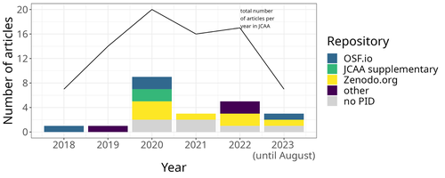
The paper “Percolation Package – From Script Sharing to Package Publication” by Sophie C. Schmidt and Simon Maddison (2023) describes the development of an R package designed to apply Percolation Analysis to archaeological spatial data. In an earlier publication, Maddison and Schmidt (2020) describe Percolation Analysis and provide case studies that demonstrate its usefulness at different spatial scales. In the current paper, the authors use their experience collaborating to develop the R package as part of a broader argument for the importance of code sharing to the research process. The paper begins by describing the development process of the R package, beginning with borrowing code from a geographer, refining it to fit archaeological case studies, and then collaborating to further refine and systematize the code into an R package that is more easily reusable by other researchers. As the review by Joe Roe noted, a strength of the paper is “presenting the development process as it actually happens rather than in an idealized form.” The authors also include a section about the lessons learned from their experience. Moving on from the anecdotal data of their own experience, the authors also explore code sharing practices in archaeology by briefly examining two datasets. One dataset comes from “open-archaeo” (https://open-archaeo.info/), an on-line list of open-source archaeological software maintained by Zack Batist. The other dataset includes articles published between 2018 and 2023 in the Journal of Computer Applications in Archaeology. Schmidt and Maddison find that these two datasets provide contrasting views of code sharing in archaeology: many of the resources in the open-archaeo list are housed on Github, lack persistent object identifiers, and many are not easily findable (other than through the open-archaeo list). Research software attached to the published articles, on the other hand, is more easily findable either as a supplement to the published article, or in a repository with a DOI. The examination of code sharing in archaeology through these two datasets is preliminary and incomplete, but it does show that further research into archaeologists’ code-writing and code-sharing practices could be useful. Archaeologists often create software tools to facilitate their research, but how often? How often is research software shared with published articles? How much attention is given to documentation or making the software usable for other researchers? What are best (or good) practices for sharing code to make it findable and usable? Schmidt and Maddison’s paper provides partial answers to these questions, but a more thorough study of code sharing in archaeology would be useful. Differences among journals in how often they publish articles with shared code, or the effects of age, gender, nationality, or context of employment on attitudes toward code sharing seem like obvious factors for a future study to consider. Shared code that is easy to find and easy to use benefits the researchers who adopt code written by others, but code authors also have much to gain by sharing. Properly shared code becomes a citable research product, and the act of code sharing can lead to productive research collaborations, as Schmidt and Maddison describe from their own experience. The strength of this paper is the attention it brings to current code-sharing practices in archaeology. I hope the paper will also help improve code sharing in archaeology by inspiring more archaeologists to share their research code so other researchers can find and use (and cite) it. References Maddison, M.S. and Schmidt, S.C. (2020). Percolation Analysis – Archaeological Applications at Widely Different Spatial Scales. Journal of Computer Applications in Archaeology, 3(1), p.269–287. https://doi.org/10.5334/jcaa.54 Schmidt, S. C., and Maddison, M. S. (2023). Percolation Package - From script sharing to package publication, Zenodo, 7966497, ver. 3 peer-reviewed and recommended by Peer Community in Archaeology. https://doi.org/10.5281/zenodo.7966497 | Percolation Package - From script sharing to package publication | Sophie C Schmidt; Simon Maddison | <p>In this paper we trace the development of an R-package starting with the adaptation of code from a different field, via scripts shared between colleagues, to a published package that is being successfully used by researchers world-wide. Our aim... | | Computational archaeology | James Allison | 2023-05-24 15:40:15 | ||
28 Feb 2021
A database of lapidary artifacts in the Caribbean for the Ceramic AgeOpen data on beads, pendants, blanks from the Ceramic Age CaribbeanRecommended by Ben Marwick based on reviews by Clarissa Belardelli, Stefano Costa, Robert Bischoff and Li-Ying Wang
The paper 'A database of lapidary artifacts in the Caribbean for the Ceramic Age' by Queffelec et al. [1] presents a description of a dataset of nearly 5000 lapidary artefacts from over 100 sites. The data are dominated by beads and pendants, which are mostly made from Diorite, Turquoise, Carnelian, Amethyst, and Serpentine. The raw material data is especially valuable as many of these are not locally available on the island. This holds great potential for exchange network analysis. The data may be especially useful for investigating one of the fundamental questions of this region: whether the Cedrosan and Huecan are separate, little related developments, with different origins, or variants or a single tradition [2]. In addition to metric and technological details about the artefacts, the data include a variety of locational details, including coordinates, distance to coast, and altitude. This enables many opportunities for future spatial analysis and geostatistical modelling to understand human behaviours relating to ornament production, use, and discard. I recommend the authors make a minor revision to Table 1 (spatial coverage of the dataset) to make the column with the citations conform to the same citation style used in the rest of the text. I warmly commend the authors for making transparency and reproducibility a priority when preparing their manuscript. Their use of the R Markdown format for writing reproducible, dynamic documents [3] is highly impressive. This is an excellent example for others in the international archaeological science community to follow. The paper is especially useful for researchers who are new to R and R Markdown because of the elegant and accessible way the authors document their research here. [1] Queffelec, A., Fouéré, P. and Caverne, J.-B. 2021. A database of lapidary artifacts in the Caribbean for the Ceramic Age. SocArXiv, 7dq3b, ver. 4 Peer-reviewed and recommended by PCI Archaeology. https://doi.org/10.31235/osf.io/7dq3b [2] Reed, J. A. and Petersen, J. B. 2001. A comparison of Huecan and Cedrosan Saladoid ceramics at the Trants site, Montserrat. In Proceedings of the XVIIIth International Congress for Caribbean Archaeology (pp. 253-267). [3] Marwick, B. 2017. Computational Reproducibility in Archaeological Research: Basic Principles and a Case Study of Their Implementation. Journal of Archaeological Method and Theory 24, 424–450. https://doi.org/10.1007/s10816-015-9272-9 | A database of lapidary artifacts in the Caribbean for the Ceramic Age | Alain Queffelec, Pierrick Fouéré, Jean-Baptiste Caverne | <p>Lapidary artifacts show an impressive abundance and diversity during the Ceramic period in the Caribbean islands, especially at the beginning of this period. Most of the raw materials used in this production do not exist naturally on the island... | | Neolithic, North America, Raw materials, South America, Spatial analysis, Symbolic behaviours | Ben Marwick | 2020-11-13 23:52:34 | ||
10 Jan 2024
Linking Scars: Topology-based Scar Detection and Graph Modeling of Paleolithic Artifacts in 3DA valuable contribution to automated analysis of palaeolithic artefactsRecommended by Sebastian Hageneuer based on reviews by Lutz Schubert and 1 anonymous reviewer
In this paper (Linsel/Bullenkamp/Mara 2024), the authors propose an automatic system for scar-ridge-pattern detection on palaeolithic artefacts based on Morse Theory. Scare-Ridge pattern recognition is a process that is usually done manually while creating a drawing of the object itself. Automatic systems to detect scars or ridges exist, but only a small amount of them is utilizing 3D data. In addition to the scar-ridges detection, the authors also experiment in automatically detecting the operational sequence, the temporal relation between scars and ridges. As a result, they can export a traditional drawing as well as graph models displaying the relationships between the scars and ridges. After an introduction to the project and the practice of documenting palaeolithic artefacts, the authors explain their procedure in automatising the analysis of scars and ridges as well as their temporal relation to each other on these artefacts. To illustrate the process, an open dataset of lithic artefacts from the Grotta di Fumane, Italy, was used and 62 artefacts selected. To establish a Ground Truth, the artefacts were first annotated manually. The authors then continue to explain in detail each step of the automated process that follows and the results obtained. In the second part of the paper, the results are presented. First the results of the segmentation process shows that the average percentage of correctly labelled vertices is over 91%, which is a remarkable result. The graph modelling however shows some more difficulties, which the authors are aware of. To enhance the process, the authors rightfully aim to include datasets of experimental archaeology in the future. They also aim to develop a way of detecting the operational sequence automatically and precisely. This paper has great potential as it showcases exactly what Digital and Computational Archaeology is about: The development of new digital methods to enhance the analysis of archaeological data. While this procedure is still in development, the authors were able to present a valuable contribution to the automatization of analytical archaeology. By creating a step towards the machine-readability of this data, they also open up the way to further steps in machine learning within Archaeology. BibliographyLinsel, F., Bullenkamp, J. P., and Mara, H. (2024). Linking Scars: Topology-based Scar Detection and Graph Modeling of Paleolithic Artifacts in 3D, Zenodo, 8296269, ver. 3 peer-reviewed and recommended by Peer Community in Archaeology. https://doi.org/10.5281/zenodo.8296269 | Linking Scars: Topology-based Scar Detection and Graph Modeling of Paleolithic Artifacts in 3D | Florian Linsel, Jan Philipp Bullenkamp & Hubert Mara | <p>Motivated by the concept of combining the archaeological practice of creating lithic artifact drawings with the potential of 3D mesh data, our goal in this project is not only to analyze the shape at the artifact level, but also to enable a mor... | | Computational archaeology, Europe, Lithic technology, Upper Palaeolithic | Sebastian Hageneuer | 2023-09-01 23:03:59 | ||
20 Jul 2022
Faunal remains from the Upper Paleolithic site of Nahal Rahaf 2 in the southern Judean Desert, IsraelNew zooarchaeological data from the Upper Palaeolithic site of Nahal Rahaf 2, IsraelRecommended by Ruth Blasco based on reviews by Ana Belén Galán and Joana Gabucio
The Levantine Corridor is considered a crossing point to Eurasia and one of the main areas for detecting population flows (and their associated cultural and economic changes) during the Pleistocene. This area could have been closed during the most arid periods, giving rise to processes of population isolation between Africa and Eurasia and intermittent contact between Eurasian human communities [1,2]. Zooarchaeological studies of the early Upper Palaeolithic assemblages constitute an important source of knowledge about human subsistence, making them central to the debate on modern behaviour. The Early Upper Palaeolithic sequence in the Levant includes two cultural entities – the Early Ahmarian and the Levantine Aurignacian. This latter is dated to 39-33 ka and is considered a local adaptation of the European Aurignacian techno-complex. In this work, the authors present a zooarchaeological study of the Nahal Rahaf 2 (ca. 35 ka) archaeological site in the southern Judean Desert in Israel [3]. Zooarchaeological data from the early Upper Paleolithic desert regions of the southern Levant are not common due to preservation problems of non-lithic finds. In the case of Nahal Rahaf 2, recent excavation seasons brought to light a stratigraphical sequence composed of very well-preserved archaeological surfaces attributed to the 'Arkov-Divshon' cultural entity, which is associated with the Levantine Aurignacian. This study shows age-specific caprine (Capra cf. Capra ibex) hunting on prime adults and a generalized procurement of gazelles (Gazella cf. Gazella gazella), which seem to have been selectively transported to the site and processed for within-bone nutrients. An interesting point to note is that the proportion of goats increases along the stratigraphic sequence, which suggests to the authors a specialization in the economy over time that is inversely related to the occupational intensity of use of the site. It is also noteworthy that the materials represent a large sample compared to previous studies from the Upper Paleolithic of the Judean Desert and Negev. In summary, this manuscript contributes significantly to the study of both the palaeoenvironment and human subsistence strategies in the Upper Palaeolithic and provides another important reference point for evaluating human hunting adaptations in the arid regions of the southern Levant. References [1] Bermúdez de Castro, J.-L., Martinon-Torres, M. (2013). A new model for the evolution of the human pleistocene populations of Europe. Quaternary Int. 295, 102-112. https://doi.org/10.1016/j.quaint.2012.02.036 [2] Bar-Yosef, O., Belfer-Cohen, A. (2010). The Levantine Upper Palaeolithic and Epipalaeolithic. In Garcea, E.A.A. (Ed), South-Eastern Mediterranean Peoples Between 130,000 and 10,000 Years Ago. Oxbow Books, pp. 144-167. [3] Marom, N., Gnezdilov, D. L., Shafir, R., Barzilai, O. and Shemer, M. (2022). Faunal remains from the Upper Paleolithic site of Nahal Rahaf 2 in the southern Judean Desert, Israel. BioRxiv, 2022.05.17.492258, ver. 4 peer-reviewed and recommended by Peer community in Archaeology. https://www.biorxiv.org/content/10.1101/2022.05.17.492258v4 | Faunal remains from the Upper Paleolithic site of Nahal Rahaf 2 in the southern Judean Desert, Israel | Nimrod Marom, Dariya Lokshin Gnezdilov, Roee Shafir, Omry Barzilai, Maayan Shemer | <p>Nahal Rahaf 2 (NR2) is an Early Upper Paleolithic (ca. 35 kya) rock shelter in the southern Judean Desert in Israel. Two excavation seasons in 2019 and 2020 revealed a stratigraphical sequence composed of intact archaeological surfaces attribut... | | Upper Palaeolithic, Zooarchaeology | Ruth Blasco | Joana Gabucio | 2022-05-19 06:16:47 | |
29 Jan 2024
Visual encoding of a 3D virtual reconstruction's scientific justification: feedback from a proof-of-concept research3D Models, Knowledge and Visualization: a prototype for 3D virtual models according to plausible criteriaRecommended by Daniel Carvalho based on reviews by Robert Bischoff and Louise TharandtThe construction of 3D realities is deeply embedded in archaeological practices. From sites to artifacts, archaeology has dedicated itself to creating digital copies for the most varied purposes. The paper “Visual encoding of a 3D virtual reconstruction's 3 scientific justification: feedback from a proof-of-concept research” (Jean-Yves et al 2024) represents an advance, in the sense that it does not just deal with a three-dimensional theory for archaeological practice, but rather offers proposals regarding the epistemic component, how it is possible to represent knowledge through the workflow of 3D virtual reconstructions themselves. The authors aim to unite three main axes - knowledge modeling, visual encoding and 3D content reuse - (Jean-Yves et al 2024: 2), which, for all intents and purposes, form the basis of this article. With regard to the first aspect, this work questions how it is possible to transmit the knowledge we want to a 3D model and how we can optimize this epistemic component. A methodology based on plausibility criteria is offered, which, for the archaeological field, offers relevant space for reflection. Given our inability to fully understand the object or site that is the subject of the 3D representation, whether in space or time, building a method based on probabilistic categories is probably one of the most realistic approaches to the realities of the past. Thus, establishing a plausibility criterion allows the user to question the knowledge that is transmitted through the representation, and can corroborate or refute it in future situations. This is because the role of reusing these models is of great interest to the authors, a perfectly justifiable sentiment, as it encourages a critical view of scientific practices. Visual encoding is, in terms of its conjunction with knowledge practices, a key element. The notion of simplicity under Maeda's (2006) design principles not only represents a way of thinking that favors operability, but also a user-friendly design in the prototype that the authors have created. This is also visible when it comes to the reuse of parts of the models, in a chronological logic: adapting the models based on architectural elements that can be removed or molded is a testament to intelligent design, whereby instead of redoing models in their entirety, they are partially used for other purposes. All these factors come together in the final prototype, a web application that combines relational databases (RDBMS) with a data mapper (MassiveJS), using the PHP programming language. The example used is the Marmoutier Abbey hostelry, a centuries-old building which, according to the sources presented, has evolved architecturally over several centuries ((Jean-Yves et al 2024: 8). These states of the building are represented visually through architectural elements based on their existence, location, shape and size, always in terms of what is presented as being plausible. This allows not only the creation of a matrix in which various categories are related to various architectural elements, but also a visual aid, through a chromatic spectrum, of the plausibility that the authors are aiming for. In short, this is an article that seeks to rethink the degree of knowledge we can obtain through 3D visualizations and that does not take models as static, but rather realities that must be explored, recycled and reinterpreted in the light of different data, users and future research. For this reason, it is a work of great relevance to theoretical advances in 3D modeling adapted to archaeology.
References Blaise, J.-Y., Dudek, I., Bergerot, L. and Gaël, S. (2024). Visual encoding of a 3D virtual reconstruction's scientific justification: feedback from a proof-of-concept research, Zenodo, 7983163, ver. 3 peer-reviewed and recommended by Peer Community in Archaeology. https://doi.org/10.5281/zenodo.10496540 John Maeda. (2006). The Laws of Simplicity. MIT Press, Cambridge, MA, USA. | Visual encoding of a 3D virtual reconstruction's scientific justification: feedback from a proof-of-concept research | J.Y Blaise, I.Dudek, L.Bergerot, G.Simon | <p> 3D virtual reconstructions have become over the last decades a classical mean to communicate about analysts’ visions concerning past stages of development of an edifice or a site. However, they still today remain quite often a one-s... | | Computational archaeology, Spatial analysis | Daniel Carvalho | 2023-05-30 00:43:03 | ||
02 Sep 2023
Towards a Mobile 3D Documentation Solution. Video Based Photogrammetry and iPhone 12 Pro as Fieldwork Documentation ToolsThe Potential of Mobile 3D Documentation using Video Based Photogrammetry and iPhone 12 ProRecommended by Ying Tung Fung based on reviews by Dominik Hagmann, Sebastian Hageneuer and 1 anonymous reviewerI am pleased to recommend the paper titled "Towards a Mobile 3D Documentation Solution. Video Based Photogrammetry and iPhone 12 Pro as Fieldwork Documentation Tools" for consideration and publication as a preprint (Paukkonen, 2023). The paper addresses a timely and relevant topic within the field of archaeology and offers valuable insights into the evolving landscape of 3D documentation methods. The advances in technology over the past decade have brought about significant changes in archaeological documentation practices. This paper makes a valuable contribution by discussing the emergence of affordable equipment suitable for 3D fieldwork documentation. Given the constraints that many archaeologists face with limited resources and tight timeframes, the comparison between photogrammetry based on a video captured by a DJI Osmo Pocket gimbal camera and iPhone 12 Pro LiDAR scans is of great significance. The research presented in the paper showcases a practical application of these new technologies in the context of a Finnish Early Modern period archaeological project. By comparing the acquisition processes and evaluating the accuracy, precision, ease of use, and time constraints associated with each method, the authors provide a comprehensive assessment of their potential for archaeological fieldwork. This practical approach is a commendable aspect of the paper, as it not only explores the technical aspects but also considers the practical implications for archaeologists on the ground. Furthermore, the paper appropriately addresses the limitations of these technologies, specifically highlighting their potential inadequacy for projects requiring a higher level of precision, such as Neolithic period excavations. This nuanced perspective adds depth to the discussion and provides a realistic portrayal of the strengths and limitations of the new documentation methods. In conclusion, the paper offers valuable insights into the future of 3D field documentation for archaeologists. The authors' thorough evaluation and practical approach make this study a valuable resource for researchers, practitioners, and professionals in the field. I believe that this paper would be an excellent addition to PCIArchaeology and would contribute significantly to the ongoing dialogue within the archaeological community. References Paukkonen, N. (2023) Towards a Mobile 3D Documentation Solution. Video Based Photogrammetry and iPhone 12 Pro as Fieldwork Documentation Tools, Zenodo, 8281263, ver. 3 peer-reviewed and recommended by Peer Community in Archaeology. https://doi.org/10.5281/zenodo.8281263 | Towards a Mobile 3D Documentation Solution. Video Based Photogrammetry and iPhone 12 Pro as Fieldwork Documentation Tools | Nikolai Paukkonen | <p>New affordable equipment suitable for 3D fieldwork documentation has appeared during the last years. Both photogrammetry and laser scanning are becoming affordable for archaeologists, who often work with limited resources and tight time constra... | | Europe, Post-medieval, Remote sensing | Ying Tung Fung | 2023-05-21 21:32:33 | ||
31 Jan 2024
Rivers vs. Roads? A route network model of transport infrastructure in Northern Italy during the Roman periodModelling Roman Transport Infrastructure in Northern ItalyRecommended by Andrew McLean based on reviews by Pau de Soto and Adam PažoutStudies of the economy of the Roman Empire have become increasingly interdisciplinary and nuanced in recent years, allowing the discipline to make great strides in data collection and importantly in the methods through which this increasing volume of data can be effectively and meaningfully analysed [see for example 1 and 2]. One of the key aspects of modelling the ancient economy is understanding movement and transport costs, and how these facilitated trade, communication and economic development. With archaeologists adopting more computational techniques and utilising GIS analysis beyond simply creating maps for simple visualisation, understanding and modelling the costs of traversing archaeological landscapes has become a much more fruitful avenue of research. Classical archaeologists are often slower to adopt these new computational techniques than others in the discipline. This is despite (or perhaps due to) the huge wealth of data available and the long period of time over which the Roman economy developed, thrived and evolved. This all means that the Roman Empire is a particularly useful proving ground for testing and perfecting new methodological developments, as well as being a particularly informative period of study for understanding ancient human behaviour more broadly. This paper by Page [3] then, is well placed and part of a much needed and growing trend of Roman archaeologists adopting these computational approaches in their research. Page’s methodology builds upon De Soto’s earlier modelling of transport costs [4] and applies it in a new setting. This reflects an important practice which should be more widely adopted in archaeology. That of using existing, well documented methodologies in new contexts to offer wider comparisons. This allows existing methodologies to be perfected and tested more robustly without reinventing the wheel. Page does all this well, and not only builds upon De Soto’s work, but does so using a case study that is particularly interesting with convincing and significant results. As Page highlights, Northern Italy is often thought of as relatively isolated in terms of economic exchange and transport, largely due to the distance from the sea and the barriers posed by the Alps and Apennines. However, in analysing this region, and not taking such presumptions for granted, Page quite convincingly shows that the waterways of the region played an important role in bringing down the cost of transport and allowed the region to be far more interconnected with the wider Roman world than previous studies have assumed. This article is clearly a valuable and important contribution to our understanding of computational methods in archaeology as well as the economy and transport network of the Roman Empire. The article utilises innovative techniques to model transport in an area of the Roman Empire that is often overlooked, with the economic isolation of the area taken for granted. Having high quality research such as this specifically analysing the region using the most current methodologies is of great importance. Furthermore, developing and improving methodologies like this allow for different regions and case studies to be analysed and directly compared, in a way that more traditional analyses simply cannot do. As such, Page has demonstrated the importance of reanalysing traditional assumptions using the new data and analyses now available to archaeologists. References [1] Brughmans, T. and Wilson, A. (eds.) (2022). Simulating Roman Economies: Theories, Methods, and Computational Models. Oxford. [2] Dodd, E.K. and Van Limbergen, D. (eds.) (2024). Methods in Ancient Wine Archaeology: Scientific Approaches in Roman Contexts. London ; New York. [3] Page, J. (2024). Rivers vs. Roads? A route network model of transport infrastructure in Northern Italy during the Roman period, Zenodo, 7971399, ver. 3 peer-reviewed and recommended by Peer Community in Archaeology. https://doi.org/10.5281/zenodo.7971399 [4] De Soto P (2019). Network Analysis to Model and Analyse Roman Transport and Mobility. In: Finding the Limits of the Limes. Modelling Demography, Economy and Transport on the Edge of the Roman Empire. Ed. by Verhagen P, Joyce J, and Groenhuijzen M. Springer Open Access, pp. 271–90. https://doi.org/10.1007/978-3-030-04576-0_13 | Rivers vs. Roads? A route network model of transport infrastructure in Northern Italy during the Roman period | James Page | <p>Northern Italy has often been characterised as an isolated and marginal area during the Roman period, a region constricted by mountain ranges and its distance from major shipping lanes. Historians have frequently cited these obstacles, alongsid... | | Classic, Computational archaeology | Andrew McLean | 2023-05-28 15:11:31 | ||
06 Oct 2023
From paper to byte: An interim report on the digital transformation of two thing editionsRevitalising archaeological corpus publications through digitisation – the Corpus der römischen Funde im europäischen Barbaricum and the Conspectus Formarum Terrae Sigillatae Modo Confectae as exemplary casesRecommended by Felix Riede, Sébastien Plutniak and Shumon Tobias Hussain based on reviews by Sebastian Hageneuer and Adéla Sobotkova
The paper entitled “From paper to byte: An interim report on the digital transformation of two thing editions” submitted by Frederic Auth and colleagues discusses how those rich and often meticulously illustrated catalogues of particular find classes that exist in many corners of archaeology can be brought to the cutting edge of contemporary research through digitisation. This paper was first developed for a special conference session convened at the EAA annual meeting in 2021 and is intended for an edited volume on the topic of typology, taxonomy, classification theory, and computational approaches in archaeology. Auth et al. (2023) begin with outlining the useful notion of the ‘thing-edition’ originally coined by Kerstin Hofmann in the context of her work with the many massive corpora of finds that have characterised, in particular, earlier archaeological knowledge production in Germany (Hofmann et al. 2019; Hofmann 2018). This work critically examines changing trends in the typological characterisation and recording of various find categories, their theoretical foundations or lack thereof and their legacy on contemporary practice. The present contribution focuses on what happens with such corpora when they are integrated into digitisation projects, specifically the efforts by the German Archaeological Institute (DAI), the so-called iDAI.world and in regard to two Roman-era material culture groups, the Corpus der römischen Funde im europäischen Barbaricum (Roman finds from beyond the empire’s borders in eight printed volumes covering thousands of finds of various categories), and the Conspectus Formarum Terrae Sigillatae Modo Confectae (Roman plain ware). Drawing on Bruno Latour’s (2005) actor-network theory (ANT), Auth et al. discuss and reflect on the challenges met and choices to be made when thing-editions are to be transformed into readily accessible data, that is as linked to open, usable data. The intellectual and infrastructural workload involved in such digitisation projects is not to be underestimated. Here, the contribution by Auth et al. excels in the manner that it does not present the finished product – the fully digitised corpora – but instead offers a glimpse ‘under the hood’ of the digitisation process as an interaction between analogue corpus, research team, and the technologies at hand. These aspects were rarely addressed in the literature, rooted in the 1970s early work (Borillo and Gardin 1974; Gaines 1981), on archaeological computerised databases, focused on technical dimensions (see Rösler 2016 for an exception). Their paper can so also be read in the broader context of heterogeneous computer-assisted knowledge ecologies and ‘mangles of practice’ (see Pickering and Guzik 2009) in which practitioners and technological structures respond to each other’s needs and attempt to cooperate in creative ways. As such, Auth et al.’s considerations not least offer valuable resources for Science and Technology Studies-inspired discussions on the cross-fertilization of archaeological theory, practice and currently emerging material and virtual research infrastructures and can be read in conjunction to Gavin Lucas’ (2022) paper on ‘machine epistemology’ due to appear in the same volume. Perhaps more importantly, however, the work by Auth and colleagues (2023) exemplifies the due diligence required in not merely turning a catalogue from paper to digital document but in transforming such catalogues into long-lasting and patently usable repositories of generations of scholars to come. Deploying the Latourian notions of trade-off and recursive reference, Auth et al. first examine the structure, strengths, and weakness of the two corpora before moving on to showing how the freshly digitised versions offer new and alternative ways of analysing the archaeological material at hand, notably through immediate visualisation opportunities, through ceramic form combinations, and relational network diagrams based on the data inherent in the respective thing-editions. Catalogues including basic descriptions and artefact illustrations exist for most if not all archaeological periods. They constitute an essential backbone of archaeological work as repeated access to primary material is impractical if not impossible. The catalogues addressed by Auth et al. themselves reflect major efforts on behalf of archaeological experts to arrive at clear and operational classifications in a pre-computerised era. The continued and expanded efforts by Auth and colleagues build on these works and clearly demonstrate the enormous analytical potential to make such data not merely more accessible but also more flexibly interoperable. Their paper will therefore be an important reference for future work with similar ambitions facing similar challenges. References Auth, Frederic, Katja Rösler, Wenke Domscheit, and Kerstin P. Hofmann. 2023. “From Paper to Byte: A Workshop Report on the Digital Transformation of Two Thing Editions.” Zenodo. https://doi.org/10.5281/zenodo.8214563 Borillo, Mario, and Jean-Claude Gardin. 1974. Les Banques de Données Archéologiques. Marseille: Éditions du CNRS. Gaines, Sylvia W., ed. 1981. Data Bank Applications in Archaeology. Tucson, AZ: University of Arizona Press. Hofmann, Kerstin P. 2018. “Dingidentitäten Und Objekttransformationen. Einige Überlegungen Zur Edition von Archäologischen Funden.” In Objektepistemologien. Zum Verhältnis von Dingen Und Wissen, edited by Markus Hilgert, Kerstin P. Hofmann, and Henrike Simon, 179–215. Berlin Studies of the Ancient World 59. Berlin: Edition Topoi. https://dx.doi.org/10.17171/3-59 Hofmann, Kerstin P., Susanne Grunwald, Franziska Lang, Ulrike Peter, Katja Rösler, Louise Rokohl, Stefan Schreiber, Karsten Tolle, and David Wigg-Wolf. 2019. “Ding-Editionen. Vom Archäologischen (Be-)Fund Übers Corpus Ins Netz.” E-Forschungsberichte des DAI 2019/2. E-Forschungsberichte Des DAI. Berlin: Deutsches Archäologisches Institut. https://publications.dainst.org/journals/efb/2236/6674 Latour, Bruno. 2005. Reassembling the Social: An Introduction to Actor-Network-Theory. Oxford: Oxford University Press. Lucas, Gavin. 2022. “Archaeology, Typology and Machine Epistemology.” Zenodo. https://doi.org/10.5281/zenodo.7622162 Pickering, Andrew, and Keith Guzik, eds. 2009. The Mangle in Practice: Science, Society, and Becoming. The Mangle in Practice. Science and Cultural Theory. Durham, NC: Duke University Press. Rösler, Katja. 2016. “Mit Den Dingen Rechnen: ‚Kulturen‘-Forschung Und Ihr Geselle Computer.” In Massendinghaltung in Der Archäologie. Der Material Turn Und Die Ur- Und Frühgeschichte, edited by Kerstin P. Hofmann, Thomas Meier, Doreen Mölders, and Stefan Schreiber, 93–110. Leiden: Sidestone Press. | From paper to byte: An interim report on the digital transformation of two thing editions | Auth. Frederic; Rösler, Katja; Domscheit, Wenke; Hofmann, Kerstin P. | <p>One specific form of publication for archaeological objects are catalogues, atlases and corpora. Kerstin Hofmann has introduced the term ‘Ding-Editionen’ (thing editions) for this category of publications that present their data in lists, short... | | Antiquity, Computational archaeology, Dating, Theoretical archaeology | Felix Riede | 2022-11-08 16:00:49 | ||
02 May 2024
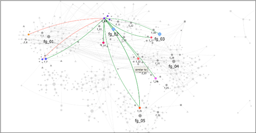
Machine Learning for UAV and Ground-Captured Imagery: Toward Standard PracticesA step forward in detecting small objects in UAV data for archaeological surveyingRecommended by Alex Brandsen based on reviews by 2 anonymous reviewers
In this paper [1], the authors describe how they apply machine learning with YOLOv5 to classify visual data, aiming to enhance understanding of archaeological phenomena before conducting destructive fieldwork. Despite challenges, the integration of machine learning with remote sensing technology was seen as transformative, enabling precise recording of areas of interest and assessment of environmental risk factors. The paper discusses successes, failures, and future directions in machine learning research, emphasising the need for standardisation and integration of streamlined methods. The application of machine learning techniques facilitates non-destructive analysis of material culture records, improving conservation efforts and offering insights into both past and contemporary phenomena. While the initial use of YOLOv5 showed potential for consistent detection of archaeological features, further refinement and dataset enlargement are deemed necessary for broader application in non-destructive archaeological surveying. The authors advocate for the integration of machine learning tools in archaeological research to save time, resources, and promote ethical digital recording practices. They highlight the importance of standardised methodologies to enhance credibility and reproducibility, aiming to contribute to the ongoing dialogue in computational archaeology. Overall, I think this paper is a good step forward in detecting small objects in UAV data, and contains useful information for similar studies. The aim towards greater reproducibility and standardisation is of course shared more widely in the machine learning community, and this study is a good example of how to approach this. References [1] Sharp, K., Christofis, B., Eslamiat, H., Nepal, U. and Osores Mendives, C. (2024). Machine Learning for UAV and Ground-Captured Imagery: Toward Standard Practices. Zenodo, 8307612, ver. 5 peer-reviewed and recommended by Peer Community in Archaeology. https://doi.org/10.5281/zenodo.8307612 | Machine Learning for UAV and Ground-Captured Imagery: Toward Standard Practices | Sharp Kayeleigh, Christofis Brooklyn, Eslamiat Hossein, Nepal Upesh, Osores Mendives Carlos | <p>Our collaborative work began in 2019 with the intent to overcome obstacles that had arisen from the inability to access curated artifact collections from remote locations. It was our specific aim to not only create digital twins of excavated ob... | | Ceramics, Computational archaeology, Remote sensing, South America | Alex Brandsen | 2023-09-01 09:56:18 | ||
02 Feb 2024
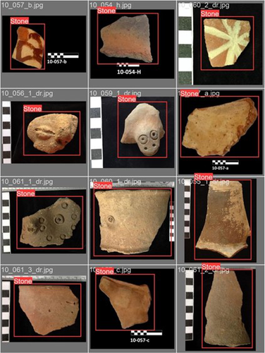
Implementing Digital Documentation Techniques for Archaeological Artifacts to Develop a Virtual Exhibition: the Necropolis of Baley CollectionOut of the storeroom and into the virtualRecommended by Jitte Waagen based on reviews by Alicia Walsh and 1 anonymous reviewer
This paper (Raykovska et al. 2023) discusses the digital documentation techniques and development of a virtual exhibition for artefacts retrieved from the necropolis of Baley, Bulgaria. The principal aim of this particular project is a solid one, trying to provide a solution to display artefacts that would otherwise remain hidden in museum storerooms. The paper describes how through a combination of 3D scanning and photogrammetry high quality 3D models have been produced, and provide content for an online virtual exhibition for the scientific community but also the larger public. It is a well-written and concise paper, in which the information on developed methods and techniques are transparently described, and various important aspects of digitization workflows, such as the importance of storing raw data, are addressed. The paper is a timely discussion on this subject, as strategies to develop digital artefact collections and what to do with those are increasingly being researched. Specifically, it discusses a workflow and its results, both in great detail. Although critical reflection on the process, goals and results from various perspectives would have been a valuable addition to the paper (cf., Jeffra 2020, Paardekoper 2019), it nonetheless provides a good practice example of how to approach the creation of a virtual museum. Those who consider projects concerning digital documentation of archaeological artefacts as well as the creation of virtual spaces to use those in for research, education or valorisation purposes would do well to read this paper carefully. References Jeffra, C., Hilditch, J., Waagen, J., Lanjouw, T., Stoffer, M., de Gelder, L., and Kim, M. J. (2020). Blending the Material and the Digital: A Project at the Intersection of Museum Interpretation, Academic Research, and Experimental Archaeology. The EXARC Journal, 2020(4). https://exarc.net/ark:/88735/10541 Paardekooper, R.P. (2019). Everybody else is doing it, so why can’t we? Low-tech and High-tech approaches in archaeological Open-Air Museums. The EXARC Journal, 2019(4). https://exarc.net/ark:/88735/10457/ Raykovska, M., Jones, K., Klecherova, H., Alexandrov, S., Petkov, N., Hristova, T., and Ivanov, G. (2023). Implementing Digital Documentation Techniques for Archaeological Artifacts to Develop a Virtual Exhibition: the Necropolis of Baley Collection. https://doi.org/10.5281/zenodo.10091870 | Implementing Digital Documentation Techniques for Archaeological Artifacts to Develop a Virtual Exhibition: the Necropolis of Baley Collection | Raykovska Miglena, Jones Kristen, Klecherova Hristina, Alexandrov Stefan, Petkov Nikolay, Hristova Tanya, Ivanov Georgi | <p>Over the past decade, virtual reality has been quickly growing in popularity across disciplines including the field of archaeology and cultural heritage. Despite numerous artifacts being uncovered each year by archaeological excavations around ... | | Ceramics, Computational archaeology, Conservation/Museum studies | Jitte Waagen | 2023-06-12 14:02:44 |


