
Latest recommendations

| Id | Title * | Authors * | Abstract * | Picture * | Thematic fields * | Recommender | Reviewers▲ | Submission date | |
|---|---|---|---|---|---|---|---|---|---|
08 Jan 2024
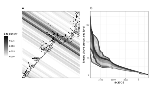
Comparing summed probability distributions of shoreline and radiocarbon dates from the Mesolithic Skagerrak coast of NorwayTaking the Reverend Bayes to the seaside: Improving Norwegian Mesolithic shoreline dating with advanced statistical approachesRecommended by Felix Riede based on reviews by 2 anonymous reviewersThe paper entitled “Comparing summed probability distributions of shoreline and radiocarbon dates from the Mesolithic Skagerrak coast of Norway” by Isak Roalkvam and Steinar Solheim (2024) sheds new light on the degree to which shoreline dating may be used as a reliable chronological and palaeodemographic proxy in the Mesolthic of southern Norway. Based on geologically motivated investigations of eustatic and isostatic sea-level changes, shoreline dating has long been used as a method to date archaeological sites in Scandinavia, not least in Norway (e.g., Bjerck 2008; Astrup 2018). Establishing reliable sea-level curves requires much effort and variations across regions may be substantial. While this topic has seen a great deal of attention in Norway specifically, many purely geological questions remain. In addition, dating archaeological sites by linking their elevation to previously established seal-level curves relies strongly on the foundational assumption that such sites were in fact shore-bound. Given the strong contrast between terrestrial and marine productivity in high-latitude regions such as Norway, this assumption per se is not unreasonable. It is very likely that the sea has played a decisive role in the lives of Stone Age peoples throughout (Persson et al. 2017), just as it has in later periods here. However, many confounding factors relating to both taphonomy and human behaviour are also likely to have loosened the shore/site relationship. Systematic variations driven by cultural norms about settlement location, mobility, as well as factors such as shelter construction, fuel use and a range of other possible factors could variously have impacted the validity or at least the precision of shoreline dating. By developing a new methodology for handling and assessing a large number of shoreline dated sites, Roalkvam and Solheim use state-of-the-art Bayesian statistical methods to compare shoreline and radiocarbon dates as proxies for population activity. The probabilistic treatment of shoreline dates in this way is novel, and the divergences between the two data sets are interpreted by the authors in light of specific behavioural, cultural, and demographic changes. Many of the peaks and troughs observed in these time-series may be interpreted in light of long-observed cultural transitions while others may relate to population dynamics now also visible in palaeogenomic analyses (Günther et al. 2018; Manninen et al. 2021). Overall, this paper makes an innovative and fresh contribution to the use of shoreline dating in Norwegian archaeology, specifically by articulating it with recent developments in Open Science and data-driven approaches to archaeological questions (Marwick et al. 2017). References Astrup, P. M. 2018. Sea-Level Change in Mesolithic Southern Scandinavia : Long- and Short-Term Effects on Society and the Environment. Aarhus: Aarhus University Press. Bjerck, H. B. 2008. Norwegian Mesolithic Trends: A Review. In Mesolithic Europe, edited by Geoff Bailey and Penny Spikins, 60–106. Cambridge: Cambridge University Press. Günther, T., Malmström, H., Svensson, E. M., Omrak, A., Sánchez-Quinto, F., Kılınç, G. M., Krzewińska, M. et al. 2018. Population Genomics of Mesolithic Scandinavia: Investigating Early Postglacial Migration Routes and High-Latitude Adaptation. PLOS Biology 16 (1): e2003703. https://doi.org/10.1371/journal.pbio.2003703 Manninen, M. A., Damlien, H., Kleppe, J. I., Knutsson, K., Murashkin, A., Niemi, A. R., Rosenvinge, C. S. and Persson, P. 2021. First Encounters in the North: Cultural Diversity and Gene Flow in Early Mesolithic Scandinavia. Antiquity 95 (380): 310–28. https://doi.org/10.15184/aqy.2020.252 Marwick, B., d’Alpoim Guedes, J. A., Barton, C. M., Bates, L. A., Baxter, M., Bevan, A., Bollwerk, E. A. et al. 2017. Open Science in Archaeology. The SAA Archaeological Record 17 (4): 8–14. https://doi.org/10.31235/osf.io/72n8g Persson, P., Riede, F., Skar, B., Breivik, H. M. and Jonsson, L. 2017. The Ecology of Early Settlement in Northern Europe: Conditions for Subsistence and Survival. Sheffield: Equinox. Roalkvam, I. and Solheim, S. (2024). Comparing summed probability distributions of shoreline and radiocarbon dates from the Mesolithic Skagerrak coast of Norway, SocArXiv, 2f8ph, ver. 5 peer-reviewed and recommended by Peer Community in Archaeology. https://doi.org/10.31235/osf.io/2f8ph | Comparing summed probability distributions of shoreline and radiocarbon dates from the Mesolithic Skagerrak coast of Norway | Isak Roalkvam, Steinar Solheim | <p>By developing a new methodology for handling and assessing a large number of shoreline dated sites, this paper compares the summed probability distribution of radiocarbon dates and shoreline dates along the Skagerrak coast of south-eastern Norw... | | Computational archaeology, Dating, Europe, Mesolithic, Paleoenvironment | Felix Riede | 2023-09-26 16:43:29 | ||
27 Jun 2024
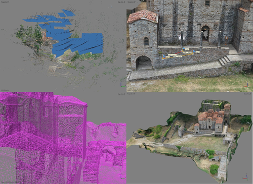
At the edge of the city: the digital storyline of the Bronchotion Monastery of MystrasMystras Captured from the Air – Digital Recording Techniques for Cultural Heritage Management of a Monumental Archaeological SiteRecommended by Jitte Waagen based on reviews by Nikolai Paukkonen and 1 anonymous reviewer based on reviews by Nikolai Paukkonen and 1 anonymous reviewer
This paper (Panagiotidis et al. 2024) discusses the digital approach to the ‘digital storyline’ of the Monastery of Brontochion of Mystras, Peloponnese, Greece. Using drone and terrestrial photogrammetric recording techniques, their goal is to produce maps and 3D models that will be integrated in the overall study of the medieval city, as well as function as a comprehensive visualisation of the archaeological site throughout its history. This will take shape as a web application using ArcGIS Online that will be a valuable platform presenting interactive visual information to accompany written publications. In addition, the assets in the database will be available for further advanced purposes, such as suggested by the authors; xR applications, educational games or digital smart guides. The authors of the paper do a good job in describing the historical background of the site and the purpose of the digital documentation techniques, and the applied methods and the technical details of the produced models are dealt with in detail. The paper presents a compelling case for an integrative approach to using digital recording techniques at an architectonically complex site for Cultural Heritage Management. It can be placed in a series of studies discussing how monumental sites can benefit from advanced digital recording techniques such as those presented in this paper (see for example Waagen and Wijngaarden 2024). The paper is recommended as an interesting read for all who are involved in this field. References Panagiotidis V. Vayia, Valantou Vasiliki, Kazolias Anastasios, and Zacharias Nikolaos. (2024). At the Edge of a City: The Digital Storyline of the Brontochion Monastery of Mystras. Zenodo, 8126952, ver. 3 peer-reviewed and recommended by Peer Community in Archaeology. https://doi.org/10.5281/zenodo.8126952 Waagen, J., and van Wijngaarden, G. J. (2024). Understanding Archaeological Site Topography: 3D Archaeology of Archaeology. Journal of Computer Applications in Archaeology, 7(1), 237–243. https://doi.org/10.5334/jcaa.157 | At the edge of the city: the digital storyline of the Bronchotion Monastery of Mystras | Panagiotidis V. Vayia; Valantou Vasiliki; Kazolias Anastasios; Zacharias Nikolaos | <p>This study focuses on the digital depiction of the storyline of the Monastery of Brontochion of Mystras, located at the southwest edge of the city of Mystras, situated at the foot of Mt. Taygetos, six kilometres west of the city of Sparta in th... | | Computational archaeology, Landscape archaeology, Mediterranean, Remote sensing, Spatial analysis | Jitte Waagen | 2023-10-03 17:02:54 | ||
12 Feb 2024
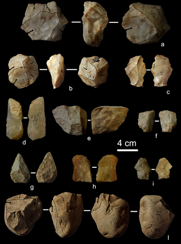
First evidence of a Palaeolithic occupation of the Po plain in Piedmont: the case of Trino (north-western Italy)Not Simply the Surface: Manifesting Meaning in What Lies Above.Recommended by Marcel Kornfeld based on reviews by Lawrence Todd, Jason LaBelle and 2 anonymous reviewersThe archaeological record comes in many forms. Some, such as buried sites from volcanic eruptions or other abrupt sedimentary phenomena are perhaps the only ones that leave relatively clean snapshots of moments in the past. And even in those cases time is compressed. Much, if not all other archaeological record is a messy affair. Things, whatever those things may be, artifacts or construction works (i.e., features), moved, modified, destroyed, warped and in a myriad of ways modified from their behavioral contexts. Do we at some point say the record is worthless? Not worth the effort or continuing investigation. Perhaps sometimes this may be justified, but as Daffara and colleagues show, heavily impacted archaeological remains can give us clues and important information about the past. Thoughtful and careful prehistorians can make significant contributions from what appear to be poor archaeological records. In the case of Daffara and colleagues, a number of important theoretical cross-sections can be recognized. For a long time surface archaeology was thought of simply as a way of getting a preliminary peak at the subsurface. From some of the earliest professional archaeologists (e.g., Kidder 1924, 1931; Nelson 1916) to the New Archaeologists of the 1960s, the link between the surface and subsurface was only improved in precision and systematization (Binford et al. 1970). However, at Hatchery West Binford and colleagues not only showed that surface material can be used more reliably to get at the subsurface, but that substantive behavioral inferences can be made with the archaeological record visible on the surface. Much more important are the behavioral implications drawn from surface material. I am not sure we can cite the first attempts at interpreting prehistory from the surface manifestations of the archaeological record, but a flurry of such approaches proliferated in the 1970s and beyond (Dunnell and Dancey 1983; Ebert 1992; Foley 1981). Off-site archaeology, non-site archaeology, later morphing into landscape archaeology all deal strictly with surface archaeological record to aid in understanding the past. With the current paper, Daffara and colleagues (2024) are clearly in this camp. Although still not widely accepted, it is clear that some behaviors (parts of systems) can only be approached from surface archaeological record. It is very unlikely that a future archaeologist will be able to excavate an entire human social/cultural system; people moving from season to season, creating multiple long and short term camps, travelling, procuring resources, etc. To excavate an entire system one would need to excavate 20,000 km2 or some similarly impossible task. Even if it was physically possible to excavate such an enormous area, it is very likely that some of contextual elements of any such system will be surface manifestations. Without belaboring the point, surface archaeological record yields data like any other archaeological record. We must contextual the archaeological artifacts or features weather they come from surface or below. Daffara and colleagues show us that we can learn about deep prehistory of northern Italy, with collections that were unsystematically collected, biased by agricultural as well as other land deformations agents. They carefully describe the regional prehistory as we know it, in particular specific well documented sites and assemblages as a means of applying such knowledge to less well controlled or uncontrolled collections.
References Binford, L., Binford, R. S. R., Whallon, R. and Hardin, M. A. (1970). Archaeology of Hatchery West. Memoirs of the Society for American Archaeology, No. 24, Washington D.C. Daffara, S., Giraudi, C., Berruti, G. L. F., Caracausi, S. and Garanzini, F. (2024). First evidence of a Palaeolithic frequentation of the Po plain in Piedmont: the case of Trino (north-western Italy), OSF Preprints, pz4uf, ver. 6 peer-reviewed and recommended by Peer Community in Archaeology. https://doi.org/10.31219/osf.io/pz4uf Dunnell, R. C. and Dancey, W. S. (1983). The siteless survey: a regional scale data collection strategy. In Advances in Archaeological Method and Theory, vol. 6, edited by Michael B. Schiffer, pp. 267-287. Academic Press, New York. Ebert, J. I. (1992). Distributional Archaeology. University of New Mexico Press, Albuquerque. Foley, R. A. (1981). Off site archaeology and human adaptation in eastern Africa: An analysis of regional artefact density in the Amboseli, Southern Kenya. British Archaeological Reports International Series 97. Cambridge Monographs in African Archaeology 3. Oxford England. Kidder, A. V. (1924). An Introduction to the Study of Southwestern Archaeology, With a Preliminary Account of the Excavations at Pecos. Papers of the Southwestern Expedition, Phillips Academy, no. 1. New Haven, Connecticut. Kidder, A. V. (1931). The Pottery of Pecos, vol. 1. Papers of the Southwestern Expedition, Phillips Academy. New Haven, Connecticut. Nelson, N. (1916). Chronology of the Tano Ruins, New Mexico. American Anthropologist 18(2):159-180. | First evidence of a Palaeolithic occupation of the Po plain in Piedmont: the case of Trino (north-western Italy) | Sara Daffara, Carlo Giraudi, Gabriele L.F. Berruti, Sandro Caracausi, Francesca Garanzini | <p>The Trino hill is an isolated relief located in north-western Italy, close to Trino municipality. The hill was subject of multidisciplinary studies during the 1970s, when, because of quarrying and agricultural activities, five concentrations of... | | Lithic technology, Middle Palaeolithic | Marcel Kornfeld | 2023-10-04 16:58:19 | ||
20 Feb 2024
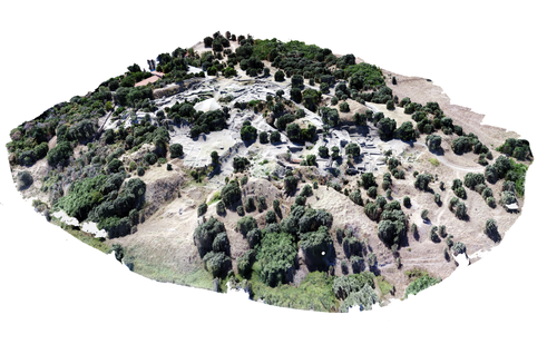
Understanding Archaeological Site Topography: 3D Archaeology of ArchaeologyRewriting Archaeological Narratives: Archaeology of Archaeology through 3D Site Topography RecordingRecommended by Devi Taelman based on reviews by Geert Verhoeven, Jesús García-Sánchez and Catherine Scott
Even though applications of 3D recording have existed in archaeology for a long time, it is only since the early 2000s that this field of research has become mainstream thanks to technological advances, and the availability of low-cost sensors and image-based modelling software. This has led to significant changes in the way archaeological sites are documented. This paper entitled "Understanding Archaeological Site Topography: 3D Archaeology of Archaeology" by Jitte Waagen & Gert Jan van Wijngaarden (2024) presents an overview of the current developments in the application possibilities of 3D site topography recording in archaeology. The paper is the result of the round table discussion "Understanding Archaeological Site Topography: 3D Archaeology of Archaeology" at the CAA conference on 5 April 2023 in Amsterdam, with contributions from Radu Brunchi, Nicola Lercari, Joep Orbons, Davide Tanasi, Alicia Walsh, Pawel Wolf and Teagan Zoldoske. The paper starts with a discussion of the Amsterdam Troy Project (ATP). In the frame of the ATP, the rich history of archaeological activity (over 150 years of fieldwork) at Troy is being studied to explore how previous archaeological research has helped to shape the current topography of the site and how these earlier research activities, embedded in their contemporary theoretical frameworks, have determined our understanding of the site (see Murray and M. Spriggs 2017, Carver 2011 for the influence of theory on archaeological fieldwork and archaeology as a discipline), the so-called 'Archaeology of Archaeology' approach. In addition to studying previous research records and re-excavating old excavation trenches, a central element of the project is the 3D recording of the past and present topography of the site in order to reconstruct the archaeological research activities at the site and their impact on the archaeological landscape. The paper focuses on current trends in 3D recording of archaeological site topography and discusses three main areas where 3D recording of archaeological site topography can contribute to the "Archaeology of Archaeology" approach: (1) monitoring the topography of sites for preservation, conservation, research and dissemination purposes; (2) reconstructing, reevaluating and reinterpreting past archaeological research efforts; and (3) archiving in a 4D (GIS) environment. This is done using the example of the Amsterdam Troy project and comparing it with other projects using similar methods and approaches. Using these case studies, the authors effectively discuss the impact of these technologies on the understanding of the topography of archaeological sites and how 3D recording can enhance archaeological research methodologies and interpretations, for example, by not using such 3D approaches as a stand-alone product but integrating them with available information from previous research activities. They also recognise the limitations and challenges involved, such as the need for customised data acquisition strategies and the lack of ready-made software solutions for developing comprehensive data management strategies. One topic that could have been covered in more detail is how 3D site topography recording (and 3D recording in general) is affected by current theoretical developments in archaeology. Like any other archaeological fieldwork or data collection approach, it is a child of its time. Decisions such as what to record, how to record, what to store, how to store, what to visualise, and how to visualise influence our understanding of archaeological sites (Ward 2022). This minor critical reflection aside, the paper makes a timely and significant contribution to archaeology by addressing current trends and the limitations of the increasingly widespread use of 3D site topography recording technologies. References Carver, G. (2011). Reflections on the archaeology of archaeological excavation, Archaeological Dialogues 18(1), pp. 18–26. https://doi.org/10.1017/S1380203811000067 Murray, T. and Spriggs, M. (2017). The historiography of archaeology: exploring theory, contingency and rationality, World Archaeology 49(2), pp. 151–157. https://doi.org/10.1080/00438243.2017.1334583 Ward, C. (2022). Excavating the Archive / Archiving the Excavation: Archival Processes and Contexts in Archaeology, Advances in Archaeological Practice 10(2), pp. 160–176. https://doi.org/10.1017/aap.2022.1 Waagen, J. and van Wijngaarden, G.J. (2024). Understanding Archaeological Site Topography: 3D Archaeology of Archaeology, Zenodo, 10061343, ver. 3 peer-reviewed and recommonded by Peer Community in Archaeology. https://doi.org/10.5281/zenodo.10061343 | Understanding Archaeological Site Topography: 3D Archaeology of Archaeology | Waagen, Jitte & Wijngaarden, Gert Jan van | <p>The current ubiquitous use of 3D recording technologies in archaeological fieldwork, for a large part due to the application of budget-friendly (drone) sensors and the availability of many low-cost image-based 3D modelling software packages, ha... | | Computational archaeology, Remote sensing | Devi Taelman | 2023-10-17 23:03:47 | ||
02 Mar 2024
A note on predator-prey dynamics in radiocarbon datasetsA new approach to Predator-prey dynamicsRecommended by Ruth Blasco based on reviews by Jesús Rodríguez, Miriam Belmaker and 1 anonymous reviewer
Various biological systems have been subjected to mathematical modelling to enhance our understanding of the intricate interactions among different species. Among these models, the predator-prey model holds a significant position. Its relevance stems not only from its application in biology, where it largely governs the coexistence of diverse species in open ecosystems, but also from its utility in other domains. Predator-prey dynamics have long been a focal point in population ecology, yet access to real-world data is confined to relatively brief periods, typically less than a century. Studying predator-prey dynamics over extended periods presents challenges due to the limited availability of population data spanning more than a century. The most extensive dataset is the hare-lynx records from the Hudson Bay Company, documenting a century of fur trade [1]. However, other records are considerably shorter, usually spanning decades [2,3]. This constraint hampers our capacity to investigate predator-prey interactions over centennial or millennial scales. Marom and Wolkowski [4] propose here that leveraging regional radiocarbon databases offers a solution to this challenge, enabling the reconstruction of predator-prey population dynamics over extensive timeframes. To substantiate this proposition, they draw upon examples from Pleistocene Beringia and the Holocene Judean Desert. This approach is highly relevant and might provide insight into ecological processes occurring at a time scale beyond the limits of current ecological datasets. The methodological approach employed in this article proposes that the summed probability distribution (SPD) of predator radiocarbon dates, which reflects changes in population size, will demonstrate either more or less variation than anticipated from random sampling in a homogeneous distribution spanning the same timeframe. A deviation from randomness would imply a covariation between predator and prey populations. This basic hypothesis makes no assumptions about the frequency, mechanism, or cause of predator-prey interactions, as it is assumed that such aspects cannot be adequately tested with the available data. If validated, this hypothesis would offer initial support for the idea that long-term regional radiocarbon data contain signals of predator-prey interactions. This approach could justify the construction of larger datasets to facilitate a more comprehensive exploration of these signal structures.
References [1] Elton, C. and Nicholson, M., 1942. The Ten-Year Cycle in Numbers of the Lynx in Canada. J. Anim. Ecol. 11, 215–244. [2] Gilg, O., Sittler, B. and Hanski, I., 2009. Climate change and cyclic predator-prey population dynamics in the high Arctic. Glob. Chang. Biol. 15, 2634–2652. https://doi.org/10.1111/j.1365-2486.2009.01927.x [3] Vucetich, J.A., Hebblewhite, M., Smith, D.W. and Peterson, R.O., 2011. Predicting prey population dynamics from kill rate, predation rate and predator-prey ratios in three wolf-ungulate systems. J. Anim. Ecol. 80, 1236–1245. https://doi.org/10.1111/j.1365-2656.2011.01855.x [4] Marom, N. and Wolkowski, U. (2024). A note on predator-prey dynamics in radiocarbon datasets, BioRxiv, 566733, ver. 4 peer-reviewed and recommended by Peer Community in Archaeology. https://doi.org/10.1101/2023.11.12.566733 | A note on predator-prey dynamics in radiocarbon datasets | Nimrod Marom, Uri Wolkowski | <p>Predator-prey interactions have been a central theme in population ecology for the past century, but real-world data sets only exist for recent, relatively short (<100 years) time spans. This limits our ability to study centennial/millennial... | | Bioarchaeology, Environmental archaeology, Palaeontology, Paleoenvironment, Zooarchaeology | Ruth Blasco | 2023-12-12 14:37:22 | ||
10 Jun 2024

Hypercultural types: archaeological objects in fast times.The Postmodern Predicament of Type-Thinking in ArchaeologyRecommended by Shumon Tobias Hussain, Felix Riede and Sébastien Plutniak based on reviews by Gavin Lucas, Miguel John Versluys and Anna S. Beck
“Hypercultural types: archaeological objects in fast times” by A. Ribeiro (1) offers some timely, critical and creative reflections on the manifold struggles of and disappointments in type-thinking and typological approaches in recent archaeological scholarship. Ribeiro insightfully situates what has been identified as a “crisis” in archaeological typo-praxis in the historical conditions of postmodernity and late capitalism themselves. The author thereby attempts what he himself considers “quite hard”, namely “to understand the current Zeitgeist and how it affects how we think and do archaeology” (p. 4). This provides a sort of historical epistemology of the present which can of course only be preliminary and incomplete as it crystallizes, takes shape, and transforms as we write these lines, is available only in fragments and hints, and is generally difficult to talk about and describe as we (the author included) lack critical distance – present-day archaeologists and fellow academics are both enfolded in postmodernity and continue to contribute to its logics and trajectories. Ribeiro’s key argument is provocative as it is interesting: he contends that archaeologists’ difficulties of coming to terms with types and typologies – staple knowledge practices of the discipline ever since – are a symptom of the changing cultural matrix of our times. The diagnosis is multilayered and complex, and Ribeiro at times only scratches the surface of what may be at stake here as he openly admits himself. At the core of his proposal is a shift in attention away from classical questions of epistemological rank, which in archaeology have tended to orbit the contentious issue of the reality of types (see also 2). Instead of foregrounding the question of type-realities – whether types, once identified, can be meaningfully said to exist and to represent something significant in the world – archaeologists are urged to recognize that typo-praxis is culturally saturated in at least two profound ways. First, devising and mobilizing types and typologies is a cultural practice itself – it may indeed have long been a foundational ‘cultural technique’ (Kulturtechnik) (3) of archaeology as a disciplined community-venture of methodical knowledge production. Typo-centric understandings of the archaeological record are quite akin to definition-centric apprehensions of the same as in both cases order, discreteness, and one-to-one correspondence are considered overriding epistemic virtues and credible pointers to a subject-independent “reality”. As such, these practices have a location of their own and they may thus notably conflict with the particularities of alternate and ever-mutating phenomenal realities and historical conditions. Discreteness may for instance lose its paradigmatic status as a descriptor of worldly order, and this is precisely what Ribeiro argues to have happened in the wake of postmodern transformations, influentially said to have deeply reconfigured the relation between the local and the global, at times even superseding such distinctions altogether. When coupled to questions of reality, types, in a similar fashion as definitions, quickly become vehicles to affirm epistemic power and knowledge authority and so help certify certain kinds of realities while supressing others. This is the paradox of modernity: to insist on monolithic understandings of the world while professing radical difference. Second, and for Ribeiro more importantly, typo-praxis is not just subject to cultural variation and thus by implication is plural, it also always has its proper associated cultural milieu in which it exerts some sort of efficacy, i.e. enables action and insight. Ribeiro maintains that this sort of efficacy has become contentious under postmodern conditions and this is because culture, under the gaze of global consumerism, has lost much of its classical significance, and as “hyperculture” (4) developed new logics, significations, and material culture correspondences, essentially “flattening” the highly textured and differentiated world of modernity (p. 6). Some of these new configurations sharply violate the expectations of traditional views of culture. The postmodern situation has in this way effectively emerged as a resistant force proffering much caution and growing scepticism among archaeologists and other academics alike as received ideas about “types” and “cultures” do not seem to work anymore the same way as before. The credibility of different modes of typo-praxis, archaeological or not, in other words, may depend much more on the cultural ecology of lived experience and contemporary diagnosis than is often realized. With Ribeiro, we may say that culture concepts and type concepts are indeed co-constitutive, and what sort of types and typologies archaeologists can persuasively deploy thus also depends greatly on how we construct the link between culture and type, and how (well) we grapple with our own realities and the lessons we draw from them – yet another important reminder of how our own subjectivities figure in such foundational debates (see esp. 5). The crisis of typo-praxis in archaeology, then, is intricately linked to the crisis of modernity, broached by Ribeiro with the labels of postmodernity and late capitalism. Upon reflection, this is not surprising at all since Tylor’s (6) influential definition of culture for example, which is extensively referenced in the paper, was both reflective of and conducive to the project of modernity and its distinctive historical formations such as empire and colonialism. Ribeiro reminds us that questions of justification and credibility, be it in the domain of type-thinking or other epistemic contexts, can never be fully divorced from the contemporary situation, and archaeologists thus need to be vigilant observers of the present, too. Typo-praxis ultimately is motivated by and draws authority from what Foucault (7) has called épistémè, the totality of pertinent parameters forming the historical a priori of understanding or the guiding unconsciousness of subjectivity within a given epoch. The crisis of archaeological typo-praxis, in this view, signifies a calling into question of the historical a priori on which much traditional type-work in archaeology was premised. Archaeologists still have to come to terms with the implications and consequences of this assessment. “Hypercultural types: archaeological objects in fast times” offers a first poignant analysis of some of these challenges of postmodern archaeological type-thinking.
Bibliography 1. Ribeiro, A. (2024). Hypercultural types: archaeological objects in fast times. Zenodo, 10567441, ver. 3 peer-reviewed and recommended by Peer Community in Archaeology. https://doi.org/10.5281/zenodo.10567441 2. Hussain, S. T. (2024). The Loss of Typological Innocence: An Archaeology of Archaeological Typo-Praxis. Zenodo, 10567441. https://doi.org/10.5281/zenodo.10547264 3. Macho, T. (2013). Second-Order Animals: Cultural Techniques of Identity and Identification. Theory, Culture & Society 30, 30–47. https://doi.org/10.1177/0263276413499189 4. Han, B.-C. (2022). Hyperculture: culture and globalization (Polity Press). 5. Frank, A., Gleiser, M. and Thompson, E. (2024). The blind spot: why science cannot ignore human experience (The MIT Press). https://doi.org/10.7551/mitpress/13711.001.0001 6. E. B. Tylor, E. B. (1871). Primitive Culture: Researches Into the Development of Mythology, Philosophy, Religion, Art, and Custom (J. Murray). 7. Foucault, M. (2007). The order of things: an archaeology of the human sciences, Repr (Routledge). | Hypercultural types: archaeological objects in fast times. | Artur Ribeiro | <p>Although artifact typologies still play a big role in archaeology, they have certainly lost some repute in recent decades. More than just a collection of items with similar attributes, typologies are a reflection of cultural behaviour and pract... | | Theoretical archaeology | Shumon Tobias Hussain | 2024-01-25 13:40:08 | ||
02 Nov 2020
Probabilistic Modelling using Monte Carlo Simulation for Incorporating Uncertainty in Least Cost Path Results: a Roman Road Case StudyA probabilistic method for Least Cost Path calculation.Recommended by Otis Crandell based on reviews by Georges Abou Diwan and 1 anonymous reviewerThe paper entitled “Probabilistic Modelling using Monte Carlo Simulation for Incorporating Uncertainty in Least Cost Path Results: a Roman Road Case Study” [1] submitted by J. Lewis presents an innovative approach to applying Least Cost Path (LCP) analysis to incorporate uncertainty of the Digital Elevation Model used as the topographic surface on which the path is calculated. The proposition of using Monte Carlo simulations to produce numerous LCP, each with a slightly different DEM included in the error range of the model, allows one to strengthen the method by proposing a probabilistic LCP rather than a single and arbitrary one which does not take into account the uncertainty of the topographic reconstruction. This new method is integrated in the R package leastcostpath [2]. The author tests the method using a Roman road built along a ridge in Cumbria, England. The integration of the uncertainty of the DEM, thanks to Monte Carlo simulations, shows that two paths could have the same probability to be the real LCP. One of them is indeed the path that the Roman road took. In particular, it is one of two possibilities of LCP in the south to north direction. This new probabilistic method therefore strengthens the reconstruction of past pathways, while also allowing new hypotheses to be tested, and, in this case study, to suggest that the northern part of the Roman road’s location was selected to help the northward movements. [1] Lewis, J., 2020. Probabilistic Modelling using Monte Carlo Simulation for Incorporating Uncertainty in Least Cost Path Results: a Roman Road Case Study. SocArXiv, mxas2, ver 17 peer-reviewed and recommended by PCI Archaeology, 10.31235/osf.io/mxas2. [2] Lewis, J., 2020. leastcostpath: Modelling Pathways and Movement Potential Within a Landscape. R package. Version 1.7.4. | Probabilistic Modelling using Monte Carlo Simulation for Incorporating Uncertainty in Least Cost Path Results: a Roman Road Case Study | Joseph Lewis | <p>The movement of past peoples in the landscape has been studied extensively through the use of Least Cost Path (LCP) analysis. Although methodological issues of applying LCP analysis in Archaeology have frequently been discussed, the effect of v... | | Spatial analysis | Otis Crandell | Adam Green, Georges Abou Diwan | 2020-08-05 12:10:46 | |
23 May 2024
The contribution of Mediterranean connectivity to morphological variability in Iron Age sheep of the Eastern MediterraneanExploring eastern Mediterranean Iron Age coastal connections through sheep astragali using geometric morphometricsRecommended by Louise Le Meillour based on reviews by 4 anonymous reviewers
It currently seems obvious that the Mediterranean basin is a place of great exchanges of cultures, populations and goods. Although studies have focused quite extensively on the archaeology of maritime exchanges [1–3], it is challenging to assess archaeologically to what extent these networks had an influence on the biology of domesticated animals in the past, or even if animals were part of the trip. The question of past populations establishing extensive connections in the Mediterranean basin during the Iron Age and Persian period and especially, if these population exchange livestock and how these connections contributed to the animals phenotype or morphotype diversity is still difficult to document in the (zoo)archaeological record. These are amongst the questions Harding et al. [4] are making an attempt at documenting. Focusing on archaeological deposits from Cyprus and Israel in the eastern part of the Mediterranean basin, they use sheep astragali as a proxy to explore the potential connections that might have existed between evolution of the animals’ morphology and exchanges through sea travel. Postulating that animals from inland sites should have variant morphology from those of coastal sites due to more intensive exchanges for the latter, mainly because of the incorporation of non-native animals, they conducted geometric morphometrics analyses to make an attempt at documenting the phenomenon. Observing changes in size and shape, but also an increased morphological variability within the assemblages from coastal sites, they nicely discuss and put their results in perspectives with the archaeological record and literature [5,6]. Although, as they acknowledge, their sample size is rather limited to draw any general conclusion, this paper sheds new lights on the influence of maritime transport and its influence over domesticated sheep diversity between Cyprus and the southern Levant, paving the way for future studies. References | The contribution of Mediterranean connectivity to morphological variability in Iron Age sheep of the Eastern Mediterranean | Sierra A. Harding, Angelos Hadjikoumis, Shyama Vermeersch, Nimrod Marom | <p>The movement of livestock across the Mediterranean is well-documented in the Neolithic era, but its significance during subsequent periods has received less attention. This study explores potential evidence for maritime connections between shee... | | Bioarchaeology, Mediterranean, Zooarchaeology | Louise Le Meillour | Anonymous | 2023-12-07 10:10:34 | |
14 Nov 2023
Student Feedback on Archaeogaming: Perspectives from a Classics ClassroomLearning with Archaeogaming? A study based on student feedbackRecommended by Sebastian Hageneuer based on reviews by Jeremiah McCall and 1 anonymous reviewer
This paper (Stephan 2023) is about the use of video games as a pedagogical tool in class. Instead of taking the perspective of a lecturer, the author seeks the student’s perspectives to evaluate the success of an interactive teaching method at the crossroads of history, archaeology, and classics. The paper starts with a literature review, that highlights the intensive use of video games among college students and high schoolers as well as the impact video games can have on learning about the past. The case study this paper is based on is made with the game Assassin’s Creed: Odyssey, which is introduced in the next part of the paper as well as previous works on the same game. The author then explains his method, which entailed the tasks students had to complete for a class in classics. They could either choose to play a video game or more classically read some texts. After the tasks were done, students filled out a 14-question-survey to collect data about prior gaming experience, assignment enjoyment, and other questions specific to the assignments. The results were based on only a fraction of the course participants (n=266) that completed the survey (n=26), which is a low number for doing statistical analysis. Besides some quantitative questions, students had also the possibility to freely give feedback on the assignments. Both survey types (quantitative answers and qualitative feedback) solely relied on the self-assessment of the students and one might wonder how representative a self-assessment is for evaluating learning outcomes. Both problems (size of the survey and actual achievements of learning outcomes) are getting discussed at the end of the paper, that rightly refers to its results as preliminary. I nevertheless think that this survey can help to better understand the role that video games can play in class. As the author rightly claims, this survey needs to be enhanced with a higher number of participants and a better way of determining the learning outcomes objectively. This paper can serve as a start into how we can determine the senseful use of video games in classrooms and what students think about doing so. References
Stephan, R. (2023). Student Feedback on Archaeogaming: Perspectives from a Classics Classroom, Zenodo, 8221286, ver. 6 peer-reviewed and recommended by Peer Community in Archaeology. https://doi.org/10.5281/zenodo.8221286
| Student Feedback on Archaeogaming: Perspectives from a Classics Classroom | Stephan, Robert | <p>This study assesses student feedback from the implementation of Assassin’s Creed: Odyssey as a teaching tool in a lower level, general education Classics course (CLAS 160B1 - Meet the Ancients: Gateway to Greece and Rome). In this course, which... | | Antiquity, Classic, Mediterranean | Sebastian Hageneuer | Anonymous, Jeremiah McCall | 2023-08-07 16:45:31 | |
01 Dec 2022
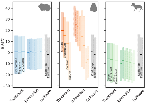
Surface texture analysis in Toothfrax and MountainsMap® SSFA module: Different software packages, different results?An important comparison of software for Scale Sensitive Fractal Analysis : are ancient and new results compatible?Recommended by Alain Queffelec and Florent Rivals based on reviews by Antony Borel and 2 anonymous reviewers
The community of archaeologists, bioanthropologist and paleontologists relying on tools use-wear and dental microwear has grown in the recent years, mainly driven by the spread of confocal microscopes in the laboratories. If the diversity of microscopes is quite high, the main software used for 3D surface texture data analysis are mostly different versions of the same Mountains Map core. In addition to this software, since the beginning of 3D surface texture analysis in dental microwear, surface sensitive fractal analysis (SSFA) initially developed for industrial research (Brown & Savary, 1991) have been performed in our disciplines with the Sfrax/Toothfrax software for two decades (Ungar et al., 2003). This software being discontinued, these calculations have been integrated to the new versions of Mountains Map, with multi-core computing, full integration in the software and an update of the calculation itself. New research based on these standard parameters of surface texture analysis will be, from now on, mainly calculated with this new add-on of Mountains Map, and will be directly compared with the important literature based on the previous software. The question addressed by Calandra et al. (2022), gathering several prominent researchers in this domain including the Mountains Map developer F. Blateyron, is key for the future research: can we directly compare SSFA results from both software? Thanks to a Bayesian approach to this question, and comparing results calculated with both software on three different datasets (two on dental microwear, one on lithic raw materials), the authors show that the two software gives statistically different results for all surface texture parameters tested in the paper. Nevertheless, applying the new calculation to the datasets, they also show that the results published in original studies with these datasets would have been similar. Authors also claim that in the future, researchers will need to re-calculate the fractal parameters of previously published 3D surfaces and cannot simply integrate ancient and new data together. We also want to emphasize the openness of the work published here. All datasets have been published online and will be probably very useful for future methodological works. Authors also published their code for statistical comparison of datasets, and proposed a fully reproducible article that allowed the reviewers to check the content of the paper, which can also make this article of high interest for student training. This article is therefore a very important methodological work for the community, as noted by all three reviewers. It will certainly support the current transition between the two software packages and it is necessary that all surface texture specialists take these results and the recommendation of authors into account: calculate again data from ancient measurements, and share the 3D surface measurements on open access repositories to secure their access in the future. References Brown CA, and Savary G (1991) Describing ground surface texture using contact profilometry and fractal analysis. Wear, 141, 211–226. https://doi.org/10.1016/0043-1648(91)90269-Z Calandra I, Bob K, Merceron G, Blateyron F, Hildebrandt A, Schulz-Kornas E, Souron A, and Winkler DE (2022) Surface texture analysis in Toothfrax and MountainsMap® SSFA module: Different software packages, different results? Zenodo, 7219877, ver. 4 peer-reviewed and recommended by Peer Community in Archaeology. https://doi.org/10.5281/zenodo.7219877 Ungar PS, Brown CA, Bergstrom TS, and Walker A (2003) Quantification of dental microwear by tandem scanning confocal microscopy and scale-sensitive fractal analyses. Scanning: The Journal of Scanning Microscopies, 25, 185–193. https://doi.org/10.1002/sca.4950250405 | Surface texture analysis in Toothfrax and MountainsMap® SSFA module: Different software packages, different results? | Ivan CALANDRA, Konstantin BOB, Gildas MERCERON, François BLATEYRON, Andreas HILDEBRANDT, Ellen SCHULZ-KORNAS, Antoine SOURON, Daniela E. WINKLER | <p>The scale-sensitive fractal analysis (SSFA) of dental microwear textures is traditionally performed using the software Toothfrax. SSFA has been recently integrated to the software MountainsMap® as an optional module. Meanwhile, Toothfrax suppor... | | Computational archaeology, Palaeontology, Traceology | Alain Queffelec | Anonymous, John Charles Willman, Antony Borel | 2022-07-07 09:58:50 |


