Latest recommendations
| Id | Title * | Authors * | Abstract * | Picture * | Thematic fields * | Recommender | Reviewers | Submission date | |
|---|---|---|---|---|---|---|---|---|---|
18 Oct 2024
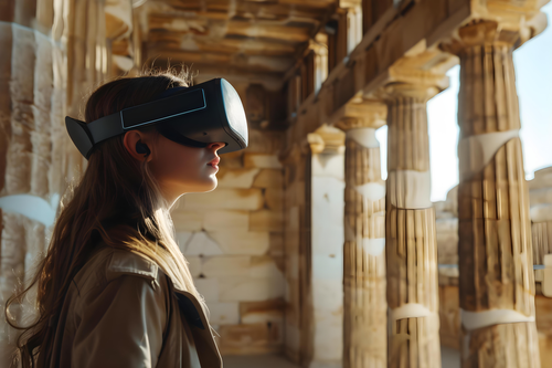
Virtual Reality Tours as an Immersive Approach to Archaeology in Higher EducationA roadmap for implementing VR-based teaching courses in archaeologyRecommended by Thomas Huet based on reviews by 3 anonymous reviewers based on reviews by 3 anonymous reviewers
Virtual Reality (VR), as a component of Extended Reality (XR), enables the visualization and exploration of archaeological sites and artifacts that are otherwise inaccessible or lost due to time, decay, or physical access constraints. As is common in archaeology, when a new technology becomes available, it is incorporated into the archaeologist's toolbox, but there remains a need to identify workflows and best practices. References Robert Stephan, Aviva Doery, Caleb Simmons (2024) Virtual Reality Tours as an Immersive Approach to Archaeology in Higher Education. Zenodo, ver.3 peer-reviewed and recommended by PCI Archaeology https://doi.org/10.5281/zenodo.13255252 | Virtual Reality Tours as an Immersive Approach to Archaeology in Higher Education | Robert Stephan, Aviva Doery, Caleb Simmons | <p>In recent years, virtual reality (VR) has emerged as a powerful technology with the potential to impact higher education. This paper examines the use of VR as a teaching tool in college classrooms, with a specific focus on its ability to provid... | | Antiquity, Classic, Europe, Mediterranean, Theoretical archaeology | Thomas Huet | 2024-08-07 16:28:41 | ||
09 Oct 2024
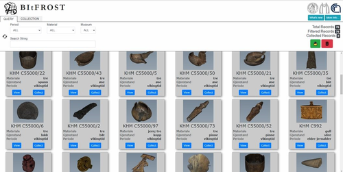
Experiences from the BItFROST Project: Developing a 3D repository at the Museum of Cultural HistoryKeeping 3D data usable - the BitFROST projectRecommended by Kristin Kruse based on reviews by Alphaeus Lien-Talks and 1 anonymous reviewer
3D technologies are now standard methods for documenting artefacts and archaeological sites. In order to make the resulting digital cultural heritage accessible to current and future generations, a long-term approach to data management is required, with continuous adjustments and consideration of the changing needs of the users. This is the conclusion of the authors Bonelli and colleagues [1], who present a project in which such a holistic approach was applied in practice. Introduced is the BitFROST platform (Bridging Research Across Heritage Studies) of the Museum of Cultural History at the University of Oslo. This self-hosted platform has been in existence since 2021 and is dedicated to optimising the long-term storage and reuse of 3D data. The project arose from the museum's legal obligations and long tradition of keeping archaeological information usable. The platform was developed with explicit consideration of user feedback to fulfil the different expectations and needs at an early stage. The BitFROST project is therefore a wonderful illustration of how change management should be practised. The article repeatedly provides brief insights into the functionalities and best practices of the platform but is particularly impressive due to its in-depth contextualisation within the state-of-the-art of digital data management. The authors show a high level of expertise and provide numerous references to further literature. The results of the user feedback are also extensively analysed, and it is explained how, for example, individual technical competence or institutional awareness lead to a great diversity of needs and how this can be counteracted with cooperation, ongoing training and continuous development (as mentioned above). I recommend this article as a very interesting case study and a well-researched white paper on complex digital data management. References Bonelli L., Pantos G. A.s, Indgjerd H., Uleberg E. (2024) Experiences from the BItFROST Project. Zenodo, ver.5 peer-reviewed and recommended by PCI Archaeology https://doi.org/10.5281/zenodo.8310062 | Experiences from the BItFROST Project: Developing a 3D repository at the Museum of Cultural History | Pantos George Alexis, Bonelli Letizia, Indgjerd Hallvard, Uleberg Espen | <p>The Museum of Cultural History has been maintaining records and publishing its catalogues since the early 19th century. In recent years the institution has been working to improve data standardisation through adoption of common vocabularies, an... | | Europe | Kristin Kruse | 2023-09-01 22:33:23 | ||
09 Sep 2024
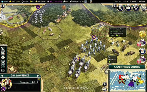
The Games of our People. Analysing Populist Nationalist Rhetorics of the Past in Historical GamesA framework for the analysis of populist nationalist rhetorics in historical gamesRecommended by Sebastian Hageneuer based on reviews by Angus Mol, Aris Politopoulos and 1 anonymous reviewer
This paper by Visonà and Cassone (2024) looks on historic video games and populist national rhetoric of the past with the goal of understanding the political implications of historical games today. Based on the works of Chapman et al. (2017) and Reinhard (2018), the paper focuses on political rhetoric and the possibility to provide forms of friction or alternative historical experiences. The paper wants to present an analytical framework to investigate these possibilities in video games and is structured into four parts. Part 1 (history and digital games) gives a short introduction into the topic of archaeogaming and the development in researching different aspects of video games. It also briefly introduces into the mechanics of knowledge transfer (see also Giere 2019). Part 2 (populist nationalism and the construction of the past) explains the dynamics of populist nationalism of the past and how these same mechanisms are on the rise again today. This makes this paper extremely relevant to today's political situation. Populist movements try to construct a past to form identity, a past that never really existed. These movements then use these identities to justify their political goals.Part 3 (analytical framework) describes the authors framework for analysis. It is structured into a matrix of three dimensions (Identitarian mythopoesis, Unavoidable conflict, Western teleology) by three procedures (Perspective, Connection, Selection), each with distinct questions to ask and answer for the researched video game. Part 4 (implementation) finally discusses how the framework works and presents some practical examples with the help of the games Assassin’s Creed III and Civilization V. The conclusions summarize the paper once more very briefly. The proposed framework is a very welcome tool in reflecting on video games in terms of the political dimensions represented. The matrix provided can give a hint on what questions to ask and how to analyze the answers. Nevertheless, a little more explanation on how to work with these questions might be helpful, especially for students wanting to utilize this matrix. The two provided examples help a lot, but it might not be clear to everyone how to use the framework. If one does however, this framework can help tremendously in video game analysis with a political focus. This is especially important today with raising populist narratives all over the world. This paper presents a very good starting point on an analytical framework for the analysis of historical video games. References Chapman, A., Foka, A., and Westin, J. (2017) Introduction: what is historical game studies? 499 Rethinking History, 21(3), 358-371. https://doi.org/10.1080/13642529.2016.1256638 Giere, D. (2019) Computerspiele - Medienbildung - historisches Lernen. Zu Repräsentation und Rezeption von Geschichte in digitalen Spielen. Forum historisches Lernen. Frankfurt am Main: Wochenschau. Reinhard, A. (2018) Archaeogaming - An Introduction to Archaeology in and of Video Games. New York - Oxford: Berghahn. Visonà, M. M. and Idone Cassone, V. (2024) The Games of our People. Analysing Populist Nationalist Rhetorics of the Past in Historical Games. Zenodo, ver.5 peer-reviewed and recommended by PCI Archaeology https://doi.org/10.5281/zenodo.8309653 | The Games of our People. Analysing Populist Nationalist Rhetorics of the Past in Historical Games | Marvin M. Visonà , Vincenzo Idone Cassone | <p>Populist Nationalist movements have been using social media and popular culture as a way to diffuse their rhetorics, by reinterpreting TV series, movies and video games through discourses aiming to seek legitimacy in the history and the past.<b... | | Theoretical archaeology | Sebastian Hageneuer | 2023-09-01 18:33:50 | ||
28 Aug 2024
IT- and machine learning-based methods of classification: The cooperative project ClaReNet – Classification and Representation for NetworksHumans, machines, and the classification of Celtic coinage – the ClaReNet projectRecommended by Felix Riede, Sébastien Plutniak and Shumon Tobias Hussain based on reviews by Alex Brandsen and Eythan Levy
The paper entitled “IT- and machine learning-based methods of classification: The cooperative project ClaReNet – Classification and Representation for Networks” submitted by Chrisowalandis Deligio and colleagues presents the joint efforts of numismatists and data scientists in classifying a large corpus of Celtic coinage. Under the project banner “ClaReNet – Classification and Representation for Networks”, they seek to explore the possibilities and also the limits of new computational methods for classification and representation. This approach seeks to rigorously keep humans in the loop in that insights from Science and Technology Studies inform the way in which knowledge generation is monitored as part of this project. The paper was first developed for a special conference session convened at the EAA annual meeting in 2021 and is intended for an edited volume on the topic of typology, taxonomy, classification theory, and computational approaches in archaeology. Deligio et al. (2024) begin with a brief and pertinent research-historical outline of Celtic coin studies with a specific focus on issues of classification. They raise interesting points about how variable degrees of standardisation in manufacture – industrial versus craft production, for instance – impact our ability to derive tidy typologies. The successes and failures of particular classificatory procedures and protocols can therefore help inform on the technological contexts of various object worlds and the particularities of human practices linked to their creation. These insights and discussion are eminently case-transferrable and applies not only to coinage, which after all is rather standardised, but to practically all material culture not made by machines – a point that gels particularly well with the contribution by Lucas (2022) to be published in the same volume. Although Deligio et al. do not flag this up specifically, the very expectation that archaeological finds should neatly fall into typological categories likely related to the objects that were initially used by pioneers of the method such as Montelius (1903) to elaborate its basic principles: these were metal objects often produced in moulds and very likely by only a very small number of highly-trained craftspeople such that the production of these objects approached the standardisation seen in industrial times (Nørgaard 2018) – see also Riede’s (2023) contribution due to be published in the same volume. At the core of Deligio and colleagues’ contribution is the exploration of machine-aided classification that should, via automation, assist in handling the often large numbers of coins available in collections and, at times, from single sites or hoards. Specifically, the authors discuss the treatment of the remarkable coin hoard from Le Câtillon II on Jersey consisting of approximately 70,000 individual Celtic coins. They proceeded to employ several advanced supervised and unsupervised classification methods to process this stupendously large number of objects. Their contribution does not stop there, however, but also seeks to articulate the discussion of machine-aided classification with more theoretically informed perspectives on knowledge production. In line with similar approaches developed in-house at the Römisch-Germanische Kommission (Hofmann 2018; Hofmann et al. 2019; Auth et al. 2023), the authors also report on their cutely acronymed PANDA (Path Dependencies, Actor-Network and Digital Agency) methodology, which they deploy to reflect on the various actors and actants – humans, software, and hardware – that come together in the creation of this new body of knowledge. This latter impetus of the paper thus lifts the lid on the many intricate, idiosyncratic, and often quirky decisions and processes that characterise research in general and research that brings together humans and machines in particular – a concrete example of the messiness of knowledge production that commonly remains hidden behind the face of the published book or paper but which science studies have long pointed at as vital components of the scientific process itself (Latour and Woolgar 1979; Galison 1997; Shapin and Schaffer 2011). In this manner, the present contribution serves as inspiration to the many similar projects that are emerging right now in demonstrating just how vital a due integration of theory, epistemology, and method is as scholars are forging their path into a future where few if any archaeological projects do not include some element of machine-assistance. References Auth, Frederic, Katja Rösler, Wenke Domscheit, and Kerstin P. Hofmann. 2023. “From Paper to Byte: A Workshop Report on the Digital Transformation of Two Thing Editions.” Zenodo. https://doi.org/10.5281/zenodo.8214563 Deligio, Chrisowalandis, Caroline von Nicolai, Markus Möller, Katja Rösler, Julia Tietz, Robin Krause, Kerstin P. Hofmann, Karsten Tolle, and David Wigg-Wolf. 2024. “IT- and Machine Learning-Based Methods of Classification: The Cooperative Project ClaReNet – Classification and Representation for Networks.” Zenodo, ver.5 peer-reviewed and recommended by PCI Archaeology https://doi.org/10.5281/zenodo.7341342 Galison, Peter Louis. 1997. Image and Logic: A Material Culture of Microphysics. Chicago, IL: University of Chicago Press. Hofmann, Kerstin P. 2018. “Dingidentitäten Und Objekttransformationen. Einige Überlegungen Zur Edition von Archäologischen Funden.” In Objektepistemologien. Zum Verhältnis von Dingen Und Wissen, edited by Markus Hilgert, Kerstin P. Hofmann, and Henrike Simon, 179–215. Berlin Studies of the Ancient World 59. Berlin: Edition Topoi. https://dx.doi.org/10.17171/3-59 Hofmann, Kerstin P., Susanne Grunwald, Franziska Lang, Ulrike Peter, Katja Rösler, Louise Rokohl, Stefan Schreiber, Karsten Tolle, and David Wigg-Wolf. 2019. “Ding-Editionen. Vom Archäologischen (Be-)Fund Übers Corpus Ins Netz.” E-Forschungsberichte des DAI 2019/2. E-Forschungsberichte Des DAI. Berlin: Deutsches Archäologisches Institut. https://publications.dainst.org/journals/efb/2236/6674 Latour, Bruno, and Steve Woolgar. 1979. Laboratory Life: The Social Construction of Scientific Facts. Laboratory Life : The Social Construction of Scientific Facts. Beverly Hills, CA: Sage. Lucas, Gavin. 2022. “Archaeology, Typology and Machine Epistemology.” Zenodo. https://doi.org/10.5281/zenodo.7622162 Montelius, Gustaf Oscar Augustin. 1903. Die Typologische Methode. Stockholm: Almqvist and Wicksell. Nørgaard, Heide Wrobel. 2018. Bronze Age Metalwork: Techniques and Traditions in the Nordic Bronze Age 1500-1100 BC. Oxford: Archaeopress Archaeology. Riede, Felix. 2023. “The Role of Heritage Databases in Typological Reification: A Case Study from the Final Palaeolithic of Southern Scandinavia.” Zenodo. https://doi.org/10.5281/zenodo.8372671 Shapin, Steven, and Simon Schaffer. 2011. Leviathan and the Air-Pump: Hobbes, Boyle, and the Experimental Life. Princeton: Princeton University Press. | IT- and machine learning-based methods of classification: The cooperative project ClaReNet – Classification and Representation for Networks | Chrisowalandis Deligio, Caroline von Nicolai, Markus Möller, Katja Rösler, Julia Tietz, Robin Krause, Kerstin P. Hofmann, Karsten Tolle, David Wigg-Wolf | <p>The classification of archaeological finds and their representation are shaped by various object epistemological approaches and changes of medium. With ever increasing digitisation, there are now new possibilities of classification, for example... | | Antiquity, Computational archaeology, Europe, Theoretical archaeology | Felix Riede | 2022-12-07 10:43:59 | ||
31 Jul 2024
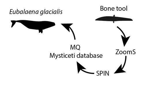
Palaeoproteomic identification of a whale bone tool from Bronze Age Heiloo, the NetherlandsPrehistoric whaling and tool industry evidenced by advanced proteomic methodsRecommended by Gwenaëlle Goude based on reviews by 2 anonymous reviewersProteomics is an increasingly applied field of study in archaeology. The characterisation of proteins in ancient biomaterials has been used extensively to determine the sex of certain animals (from dental enamel) or to identify species from non-diagnostic bone pieces or fragments of organic materials (glues and residues, for example). Paleoproteomics has been accompanied by methodological developments, in particular to reduce the size of samples affected by destructive analyses and to refine the level of species determination. The article by Joannes Dekker and colleagues (2024) - "Palaeoproteomic identification of a whale bone tool from Bronze Age Heiloo, the Netherlands" - provides a relevant and innovative example, incorporating ZooMS and SPIN techniques as well as the creation of a database of new reference collagens (cetaceans) specific to the site's natural environment (North Sea coast). The interest of this study also lies in the contribution of a use-wear analysis carried out prior to the sampling. This comparison of multidisciplinary data is essential for understanding the links between man and his natural environment and the technical and economic production that is closely linked to it. The tool studied (ca. 1500 BCE) comes from a coastal Bronze Age site in the Netherlands, where the economy was highly diversified, involving the exploitation of wild and domestic animals in both terrestrial and marine environments. The study shows that the bone of a North Atlantic right whale (Eubalaena glacialis) was shaped into a tool that was probably used to process plant fibres. This discovery supports other studies highlighting the intensive and non-opportunistic exploitation of whales in the North Sea since the Pleistocene. Dekker, J. A. A., Mylopotamitaki, D., Verbaas, A., Sinet-Mathiot, V., Presslee, S., McCarthy, M. L., Olsen, M. T., Olsen, J. V., van den Hurk, Y., Brattinga, J. & Welker, F. (2024) Palaeoproteomic identification of a whale bone tool from Bronze Age Heiloo, the Netherlands. BioRxiv, ver. 2 peer-reviewed and recommended by Peer Community in Archaeology. https://doi.org/10.1101/2024.04.15.589626 | Palaeoproteomic identification of a whale bone tool from Bronze Age Heiloo, the Netherlands | Joannes A. A. Dekker, Dorothea Mylopotamitaki, Annemieke Verbaas, Virginie Sinet-Mathiot, Samantha Presslee, Morgan L. McCarthy, Morten T. Olsen, Jesper V. Olsen, Youri van den Hurk, Joris Brattinga, Frido Welker | <p>Identification of the taxonomic origin of bone tools is an important, but often complicated, component of studying past societies. The species used for bone tool production provide insight into what species were exploited, potentially how, and ... | | Bioarchaeology, Europe, Osseous industry, Raw materials | Gwenaëlle Goude | Anonymous, Anonymous | 2024-04-20 23:30:47 | |
04 Jul 2024
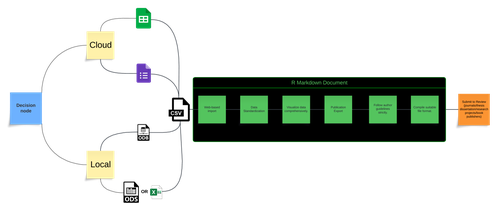
An approach to establishing a workflow pipeline for synergistic analysis of osteological and biochemical data. The case study of Amvrakia in the context of Corinthian colonisation between 625-189 BC in Epirus, Greece.Establishing a workflow for recording and analysing bioarchaeological dataRecommended by Christianne Fernee based on reviews by 2 anonymous reviewersThe paper by Xanthopoulos and colleagues [1] presents an approach to establish a pipeline for the analysis of osteological and biochemical data. This approach integrates novel data collection, FAIR principles for data longevity and accessibility, utilises R markdown and cloud webware. Following the changes recommended by the reviewers this paper presents a welcome contribution to osteoarcheology and bioarchaeology. Osteoarchaeology and bioarchaeology often involves the collection of vast amounts of data both in the field and from consequential analysis in the lab. From this data we can reconstruct many aspects of past human experiences. However, issues often arise when bringing together these diverse types of data. In this regard, this paper proposes are useful methodology in which osteoarchaeological researchers can bring their data together as part of a streamlined process, from data collection to analyses.
References [1] Xanthopoulos, K., Georgiadou, A. and Papageorgopoulou, C. (2024). An approach to establishing a workflow pipeline for synergistic analysis of osteological and biochemical data. The case study of Amvrakia in the context of Corinthian colonisation between 625-189 BC in Epirus, Greece. Zenodo, 11156506, ver. 3 peer-reviewed and recommended by Peer Community in Archaeology. https://doi.org/10.5281/zenodo.8298579 | An approach to establishing a workflow pipeline for synergistic analysis of osteological and biochemical data. The case study of Amvrakia in the context of Corinthian colonisation between 625-189 BC in Epirus, Greece. | Kiriakos Xanthopoulos, Angeliki Georgiadou, Christina Papageorgopoulou | <p>Bioarchaeology has long focused on understanding past human life through skeletal remains, including oral pathology and stable isotope analysis. Despite advancements in statistical analysis, correlations are still largely made manually. To stre... | | Antiquity, Bioarchaeology, Computational archaeology, Conservation/Museum studies, Mediterranean, Physical anthropology | Christianne Fernee | 2023-08-30 14:01:44 | ||
27 Jun 2024
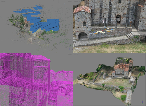
At the edge of the city: the digital storyline of the Bronchotion Monastery of MystrasMystras Captured from the Air – Digital Recording Techniques for Cultural Heritage Management of a Monumental Archaeological SiteRecommended by Jitte Waagen based on reviews by Nikolai Paukkonen and 1 anonymous reviewer
This paper (Panagiotidis et al. 2024) discusses the digital approach to the ‘digital storyline’ of the Monastery of Brontochion of Mystras, Peloponnese, Greece. Using drone and terrestrial photogrammetric recording techniques, their goal is to produce maps and 3D models that will be integrated in the overall study of the medieval city, as well as function as a comprehensive visualisation of the archaeological site throughout its history. This will take shape as a web application using ArcGIS Online that will be a valuable platform presenting interactive visual information to accompany written publications. In addition, the assets in the database will be available for further advanced purposes, such as suggested by the authors; xR applications, educational games or digital smart guides. The authors of the paper do a good job in describing the historical background of the site and the purpose of the digital documentation techniques, and the applied methods and the technical details of the produced models are dealt with in detail. The paper presents a compelling case for an integrative approach to using digital recording techniques at an architectonically complex site for Cultural Heritage Management. It can be placed in a series of studies discussing how monumental sites can benefit from advanced digital recording techniques such as those presented in this paper (see for example Waagen and Wijngaarden 2024). The paper is recommended as an interesting read for all who are involved in this field. References Panagiotidis V. Vayia, Valantou Vasiliki, Kazolias Anastasios, and Zacharias Nikolaos. (2024). At the Edge of a City: The Digital Storyline of the Brontochion Monastery of Mystras. Zenodo, 8126952, ver. 3 peer-reviewed and recommended by Peer Community in Archaeology. https://doi.org/10.5281/zenodo.8126952 Waagen, J., and van Wijngaarden, G. J. (2024). Understanding Archaeological Site Topography: 3D Archaeology of Archaeology. Journal of Computer Applications in Archaeology, 7(1), 237–243. https://doi.org/10.5334/jcaa.157 | At the edge of the city: the digital storyline of the Bronchotion Monastery of Mystras | Panagiotidis V. Vayia; Valantou Vasiliki; Kazolias Anastasios; Zacharias Nikolaos | <p>This study focuses on the digital depiction of the storyline of the Monastery of Brontochion of Mystras, located at the southwest edge of the city of Mystras, situated at the foot of Mt. Taygetos, six kilometres west of the city of Sparta in th... | | Computational archaeology, Landscape archaeology, Mediterranean, Remote sensing, Spatial analysis | Jitte Waagen | 2023-10-03 17:02:54 | ||
10 Jun 2024

Hypercultural types: archaeological objects in fast times.The Postmodern Predicament of Type-Thinking in ArchaeologyRecommended by Shumon Tobias Hussain, Felix Riede and Sébastien Plutniak based on reviews by Gavin Lucas, Miguel John Versluys and Anna S. Beck
“Hypercultural types: archaeological objects in fast times” by A. Ribeiro (1) offers some timely, critical and creative reflections on the manifold struggles of and disappointments in type-thinking and typological approaches in recent archaeological scholarship. Ribeiro insightfully situates what has been identified as a “crisis” in archaeological typo-praxis in the historical conditions of postmodernity and late capitalism themselves. The author thereby attempts what he himself considers “quite hard”, namely “to understand the current Zeitgeist and how it affects how we think and do archaeology” (p. 4). This provides a sort of historical epistemology of the present which can of course only be preliminary and incomplete as it crystallizes, takes shape, and transforms as we write these lines, is available only in fragments and hints, and is generally difficult to talk about and describe as we (the author included) lack critical distance – present-day archaeologists and fellow academics are both enfolded in postmodernity and continue to contribute to its logics and trajectories. Ribeiro’s key argument is provocative as it is interesting: he contends that archaeologists’ difficulties of coming to terms with types and typologies – staple knowledge practices of the discipline ever since – are a symptom of the changing cultural matrix of our times. The diagnosis is multilayered and complex, and Ribeiro at times only scratches the surface of what may be at stake here as he openly admits himself. At the core of his proposal is a shift in attention away from classical questions of epistemological rank, which in archaeology have tended to orbit the contentious issue of the reality of types (see also 2). Instead of foregrounding the question of type-realities – whether types, once identified, can be meaningfully said to exist and to represent something significant in the world – archaeologists are urged to recognize that typo-praxis is culturally saturated in at least two profound ways. First, devising and mobilizing types and typologies is a cultural practice itself – it may indeed have long been a foundational ‘cultural technique’ (Kulturtechnik) (3) of archaeology as a disciplined community-venture of methodical knowledge production. Typo-centric understandings of the archaeological record are quite akin to definition-centric apprehensions of the same as in both cases order, discreteness, and one-to-one correspondence are considered overriding epistemic virtues and credible pointers to a subject-independent “reality”. As such, these practices have a location of their own and they may thus notably conflict with the particularities of alternate and ever-mutating phenomenal realities and historical conditions. Discreteness may for instance lose its paradigmatic status as a descriptor of worldly order, and this is precisely what Ribeiro argues to have happened in the wake of postmodern transformations, influentially said to have deeply reconfigured the relation between the local and the global, at times even superseding such distinctions altogether. When coupled to questions of reality, types, in a similar fashion as definitions, quickly become vehicles to affirm epistemic power and knowledge authority and so help certify certain kinds of realities while supressing others. This is the paradox of modernity: to insist on monolithic understandings of the world while professing radical difference. Second, and for Ribeiro more importantly, typo-praxis is not just subject to cultural variation and thus by implication is plural, it also always has its proper associated cultural milieu in which it exerts some sort of efficacy, i.e. enables action and insight. Ribeiro maintains that this sort of efficacy has become contentious under postmodern conditions and this is because culture, under the gaze of global consumerism, has lost much of its classical significance, and as “hyperculture” (4) developed new logics, significations, and material culture correspondences, essentially “flattening” the highly textured and differentiated world of modernity (p. 6). Some of these new configurations sharply violate the expectations of traditional views of culture. The postmodern situation has in this way effectively emerged as a resistant force proffering much caution and growing scepticism among archaeologists and other academics alike as received ideas about “types” and “cultures” do not seem to work anymore the same way as before. The credibility of different modes of typo-praxis, archaeological or not, in other words, may depend much more on the cultural ecology of lived experience and contemporary diagnosis than is often realized. With Ribeiro, we may say that culture concepts and type concepts are indeed co-constitutive, and what sort of types and typologies archaeologists can persuasively deploy thus also depends greatly on how we construct the link between culture and type, and how (well) we grapple with our own realities and the lessons we draw from them – yet another important reminder of how our own subjectivities figure in such foundational debates (see esp. 5). The crisis of typo-praxis in archaeology, then, is intricately linked to the crisis of modernity, broached by Ribeiro with the labels of postmodernity and late capitalism. Upon reflection, this is not surprising at all since Tylor’s (6) influential definition of culture for example, which is extensively referenced in the paper, was both reflective of and conducive to the project of modernity and its distinctive historical formations such as empire and colonialism. Ribeiro reminds us that questions of justification and credibility, be it in the domain of type-thinking or other epistemic contexts, can never be fully divorced from the contemporary situation, and archaeologists thus need to be vigilant observers of the present, too. Typo-praxis ultimately is motivated by and draws authority from what Foucault (7) has called épistémè, the totality of pertinent parameters forming the historical a priori of understanding or the guiding unconsciousness of subjectivity within a given epoch. The crisis of archaeological typo-praxis, in this view, signifies a calling into question of the historical a priori on which much traditional type-work in archaeology was premised. Archaeologists still have to come to terms with the implications and consequences of this assessment. “Hypercultural types: archaeological objects in fast times” offers a first poignant analysis of some of these challenges of postmodern archaeological type-thinking.
Bibliography 1. Ribeiro, A. (2024). Hypercultural types: archaeological objects in fast times. Zenodo, 10567441, ver. 3 peer-reviewed and recommended by Peer Community in Archaeology. https://doi.org/10.5281/zenodo.10567441 2. Hussain, S. T. (2024). The Loss of Typological Innocence: An Archaeology of Archaeological Typo-Praxis. Zenodo, 10567441. https://doi.org/10.5281/zenodo.10547264 3. Macho, T. (2013). Second-Order Animals: Cultural Techniques of Identity and Identification. Theory, Culture & Society 30, 30–47. https://doi.org/10.1177/0263276413499189 4. Han, B.-C. (2022). Hyperculture: culture and globalization (Polity Press). 5. Frank, A., Gleiser, M. and Thompson, E. (2024). The blind spot: why science cannot ignore human experience (The MIT Press). https://doi.org/10.7551/mitpress/13711.001.0001 6. E. B. Tylor, E. B. (1871). Primitive Culture: Researches Into the Development of Mythology, Philosophy, Religion, Art, and Custom (J. Murray). 7. Foucault, M. (2007). The order of things: an archaeology of the human sciences, Repr (Routledge). | Hypercultural types: archaeological objects in fast times. | Artur Ribeiro | <p>Although artifact typologies still play a big role in archaeology, they have certainly lost some repute in recent decades. More than just a collection of items with similar attributes, typologies are a reflection of cultural behaviour and pract... | | Theoretical archaeology | Shumon Tobias Hussain | 2024-01-25 13:40:08 | ||
23 May 2024
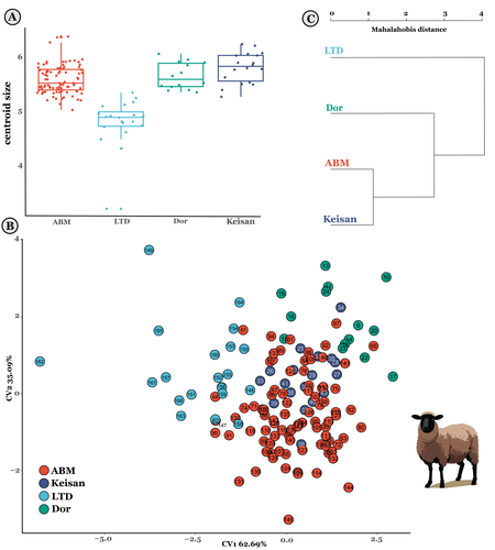
The contribution of Mediterranean connectivity to morphological variability in Iron Age sheep of the Eastern MediterraneanExploring eastern Mediterranean Iron Age coastal connections through sheep astragali using geometric morphometricsRecommended by Louise Le Meillour based on reviews by 4 anonymous reviewers
It currently seems obvious that the Mediterranean basin is a place of great exchanges of cultures, populations and goods. Although studies have focused quite extensively on the archaeology of maritime exchanges [1–3], it is challenging to assess archaeologically to what extent these networks had an influence on the biology of domesticated animals in the past, or even if animals were part of the trip. The question of past populations establishing extensive connections in the Mediterranean basin during the Iron Age and Persian period and especially, if these population exchange livestock and how these connections contributed to the animals phenotype or morphotype diversity is still difficult to document in the (zoo)archaeological record. These are amongst the questions Harding et al. [4] are making an attempt at documenting. Focusing on archaeological deposits from Cyprus and Israel in the eastern part of the Mediterranean basin, they use sheep astragali as a proxy to explore the potential connections that might have existed between evolution of the animals’ morphology and exchanges through sea travel. Postulating that animals from inland sites should have variant morphology from those of coastal sites due to more intensive exchanges for the latter, mainly because of the incorporation of non-native animals, they conducted geometric morphometrics analyses to make an attempt at documenting the phenomenon. Observing changes in size and shape, but also an increased morphological variability within the assemblages from coastal sites, they nicely discuss and put their results in perspectives with the archaeological record and literature [5,6]. Although, as they acknowledge, their sample size is rather limited to draw any general conclusion, this paper sheds new lights on the influence of maritime transport and its influence over domesticated sheep diversity between Cyprus and the southern Levant, paving the way for future studies. References | The contribution of Mediterranean connectivity to morphological variability in Iron Age sheep of the Eastern Mediterranean | Sierra A. Harding, Angelos Hadjikoumis, Shyama Vermeersch, Nimrod Marom | <p>The movement of livestock across the Mediterranean is well-documented in the Neolithic era, but its significance during subsequent periods has received less attention. This study explores potential evidence for maritime connections between shee... | | Bioarchaeology, Mediterranean, Zooarchaeology | Louise Le Meillour | Anonymous | 2023-12-07 10:10:34 | |
16 May 2024
A return to function as the basis of lithic classificationUsing insights from psychology and primatology to reconsider function in lithic typologiesRecommended by Sébastien Plutniak, Felix Riede and Shumon Tobias Hussain based on reviews by Vincent Delvigne and 1 anonymous reviewer
The paper “A return to function as the basis of lithic classification” by Radu Iovita (2024) is a contribution to an upcoming volume on the role of typology and type-thinking in current archaeological theory and praxis edited by the PCI recommenders. In this context, the paper offers an in-depth discussion of several crucial dimensions of typological thinking in past and current lithic studies, namely:
Discussing and importantly re-articulating these concepts, Iovita ultimately aims at “establishing unified guiding principles for studying a technology that spans several million years and several different species whose brain capacities range from ca. 300–1400 cm³”. The notion that tool function should dictate classification is not new (e.g. Gebauer 1987). It is particularly noteworthy, however, that the paper engages carefully with various relevant contributions on the topic from non-Anglophone research traditions. First, its considering works on lithic typologies published in other languages, such as Russian (Sergei Semenov), French (Georges Laplace), and German (Joachim Hahn). Second, it takes up the ideas of two French techno-anthropologists, in particular:
Interestingly, Iovita grounds his argumentation on insights from primatology, psychology and the cognitive sciences, to the extent that they fuel discussion on archaeological concepts and methods. Results regarding the so-called “design stance” for example play a crucial role: coined by philosopher and cognitive scientist and philosopher Daniel Dennett (1942-2024), this notion encompasses the possible discrepancies between the designer’s intended purpose and the object's current functions. DIF, as discussed by Iovita, directly relates to this idea, illustrating how concepts from other sciences can fruitfully be injected into archaeological thinking. Lastly, readers should note the intellectual contents generated on PCI as part of the reviewing process of the paper itself: both the reviewers and the author have engaged in in-depth discussions on the idea of (tool) “function” and its contested relationship with form or typology, delineating and mapping different views on these key issues in lithic study which are worth reading on their own. ReferencesGebauer, A. B. (1987). Stylistic Analysis. A Critical Review of Concepts, Models, and Interpretations, Journal of Danish Archaeology, 6, p. 223–229. Geertz, C. (1975). Common Sense as a Cultural System, The Antioch Review, 33 (1), p. 5–26. Iovita, R. (2024). A return to function as the basis of lithic classification. Zenodo, 7734147, ver. 5 peer-reviewed and recommended by Peer Community in Archaeology. https://doi.org/10.5281/zenodo.7734147 Lévi-Strauss, C. (1962). La pensée sauvage. Paris: Plon. Lévi-Strauss, C. (2021). Wild Thought: A New Translation of “La Pensée sauvage”. Translated by Jeffrey Mehlman & John Leavitt. Chicago, Illinois: University of Chicago Press. Sigaut, F. (1991). “Un couteau ne sert pas à couper, mais en coupant. Structure, fonctionnement et fonction dans l'analyse des objets” in 25 Ans d'études technologiques en préhistoire : Bilan et perspectives, Juan-les-Pins: Éditions de l'association pour la promotion et la diffusion des connaissances archéologiques, p. 21-34. | A return to function as the basis of lithic classification | Radu Iovita | <p>Complex tool use is one of the defining characteristics of our species, and, because of the good preservation of stone tools (lithics), one of the few which can be studied on the evolutionary time scale. However, a quick look at the lithics lit... | | Ancient Palaeolithic, Lithic technology, Theoretical archaeology, Traceology | Sébastien Plutniak | 2023-03-14 19:01:40 |


