
Latest recommendations

| Id | Title * | Authors * | Abstract * | Picture * | Thematic fields * | Recommender▲ | Reviewers | Submission date | |
|---|---|---|---|---|---|---|---|---|---|
28 Aug 2023
Geometric Morphometric Analysis of Projectile Points from the Southwest United States2D Geometric Morphometrics of Projectile Points from the Southwestern United StatesRecommended by Adrian L. Burke based on reviews by James Conolly and 1 anonymous reviewerBischoff (2023) is a significant contribution to the growing field of geometric morphometric analysis in stone tool analysis. The subject is projectile points from the southwestern United States. Projectile point typologies or systematics remain an important part of North American archaeology, and in fact these typologies continue to be used primarily as cultural-historical markers. This article looks at projectile point types using a 2D image geometric morphometric analysis as a way of both improving on projectile point types but also testing if these types are in fact based in measurable reality. A total of 164 point outlines are analyzed using Elliptical Fourier, semilandmark and landmark analyses. The author also uses a network analysis to look at possible relationships between projectile point morphologies in space. This is a clever way of working around the predefined distributions of projectile point types, some of which are over 100 years old. Because of the dynamic nature of stone tools in terms of their use, reworking and reuse, this article can also provide solutions for studying the dynamic nature of stone tools. This article therefore also has a wide applicability to other stone tool analyses. Reference Bischoff, R. J. (2023) Geometric Morphometric Analysis of Projectile Points from the Southwest United States, SocArXiv, a6wjc, ver. 8 peer-reviewed and recommended by Peer Community in Archaeology. https://doi.org/10.31235/osf.io/a6wjc | Geometric Morphometric Analysis of Projectile Points from the Southwest United States | Robert J. Bischoff | <p style="text-align: justify;">Traditional analyses of projectile points often use visual identification, the presence or absence of discrete characteristics, or linear measurements and angles to classify points into distinct types. Geometric mor... | | Archaeometry, Computational archaeology, Lithic technology, North America | Adrian L. Burke | 2022-12-18 03:38:14 | ||
17 Jun 2022
Light in the Cave: Opal coating detection by UV-light illumination and fluorescence in a rock art context. Methodological development and application in Points Cave (Gard, France)New method for the in situ detection and characterisation of amorphous silica in rock art contextsRecommended by Aitor Ruiz-Redondo based on reviews by Alain Queffelec, Laure Dayet and 1 anonymous reviewerSilica coating developed in cave art walls had an impact in the preservation of the paintings themselves. Despite it still exists a controversy about whether or not the effects contribute to the preservation of the artworks; it is evident that identifying these silica coatings would have an impact to assess the taphonomy of the walls and the paintings preserved on them. Unfortunately, current techniques -especially non-invasive ones- can hardly address amorphous silica characterisation. Thus, its presence is often detected on laboratory observations such as SEM or XRD analyses. In the paper “Light in the Cave: Opal coating detection by UV-light illumination and fluorescence in a rock art context - Methodological development and application in Points Cave (Gard, France)”, Quiers and collaborators propose a new method for the in situ detection and characterisation of amorphous silica in a rock art context based on UV laser-induced fluorescence (LIF) and UV illumination [1]. The results from both methods presented by the authors are convincing for the detection of U-silica mineralisation (U-opal in the specific case of study presented). This would allow access to a fast and cheap method to identify this kind of formations in situ in decorated caves. Beyond the relationship between opal coating and the preservation of the rock art, the detection of silica mineralisation can have further implications. First, it can help to define spot for sampling for pigment compositions, as well as reconstruct the chronology of the natural history of the caves and its relation with the human frequentation and activities. In conclusion, I am glad to recommend this original research, which offers a new approach to the identification of geological processes that affect -and can be linked with- the Palaeolithic cave art. [1] Quiers, M., Chanteraud, C., Maris-Froelich, A., Chalmin-Aljanabi, E., Jaillet, S., Noûs, C., Pairis, S., Perrette, Y., Salomon, H., Monney, J. (2022) Light in the Cave: Opal coating detection by UV-light illumination and fluorescence in a rock art context. Methodological development and application in Points Cave (Gard, France). HAL, hal-03383193, ver. 5 peer-reviewed and recommended by Peer community in Archaeology. https://hal.archives-ouvertes.fr/hal-03383193v5 | Light in the Cave: Opal coating detection by UV-light illumination and fluorescence in a rock art context. Methodological development and application in Points Cave (Gard, France) | Marine Quiers, Claire Chanteraud, Andréa Maris-Froelich, Émilie Chalmin-Aljanabi, Stéphane Jaillet, Camille Noûs, Sébastien Pairis, Yves Perrette, Hélène Salomon, Julien Monney | <p style="text-align: justify;">Silica coatings development on rock art walls in Points Cave questions the analytical access to pictorial matter specificities (geochemistry and petrography) and the rock art conservation state in the context of pig... | | Archaeometry, Europe, Rock art, Taphonomy, Upper Palaeolithic | Aitor Ruiz-Redondo | 2021-10-25 11:12:48 | ||
11 Jan 2022
Tektite geoarchaeology in mainland Southeast AsiaTektites as chronological markers: after careful geoarchaeological validation only!Recommended by Alain Queffelec and Shanti Pappu based on reviews by Sheila Mishra, Toshihiro Tada, Mike Morley and 1 anonymous reviewer and Shanti Pappu based on reviews by Sheila Mishra, Toshihiro Tada, Mike Morley and 1 anonymous reviewer
Tektites, a naturally occurring glass produced by major cosmic impacts and ejected at long distances, are known from five impacts worldwide [1]. The presence of this impact-generated glass, which can be dated in the same way as a volcanic rock, has been used to date archaeological sites in several regions of the world. This paper by Marwick and colleagues [2] reviews and adds new data on the use and misuse of this specific material as a chronological marker in Australia, East and Southeast Asia, where an impact dated to 0.78 Ma created and widely distributed tektites. This material, found in archaeological excavations in China, Laos, Thaïland, Australia, Borneo, and Vietnam, has been used to date layers containing lithic artifacts, sometimes creating a strong debate about the antiquity of the occupation and lithic production in certain regions. The review of existing data shows that geomorphological data and stratigraphic integrity can be questioned at many sites that have yielded tektites. The new data provided by this paper for five archaeological sites located in Vietnam confirm that many deposits containing tektites are indeed lag deposits and that these artifacts, thus in secondary position, cannot be considered to date the layer. This study also emphasizes the general lack of other dating methods that would allow comparison with the tektite age. In the Vietnamese archaeological sites presented here, discrepancies between methods, and the presence of historical artifacts, confirm that the layers do not share similar age with the cosmic impact that created the tektites. Based on this review and these new results, and following previous propositions [3], Marwick and colleagues conclude that, if tektites can be used as chronological markers, one has to prove that they are in situ. They propose that geomorphological assessment of the archaeological layer as primary deposit must first be attained, in addition to several parameters of the tektites themselves (shape, size distribution, chemical composition). Large error can be made by using only tektites to date an archaeological layer, and this material should not be used solely due to risks of high overestimation of the age of the archaeological production. [1] Rochette, P., Beck, P., Bizzarro, M., Braucher, R., Cornec, J., Debaille, V., Devouard, B., Gattacceca, J., Jourdan, F., Moustard, F., Moynier, F., Nomade, S., Reynard, B. (2021). Impact glasses from Belize represent tektites from the Pleistocene Pantasma impact crater in Nicaragua. Communications Earth & Environment, 2(1), 1–8, https://doi.org/10.1038/s43247-021-00155-1 [2] Marwick, B., Son, P. T., Brewer, R., Wang, L.-Y. (2022). Tektite geoarchaeology in mainland Southeast Asia. SocArXiv, 93fpa, ver. 6 peer-reviewed and recommended by PCI Archaeology, https://doi.org/10.31235/osf.io/93fpa. [3] Tada, T., Tada, R., Chansom, P., Songtham, W., Carling, P. A., Tajika, E. (2020). In Situ Occurrence of Muong Nong-Type Australasian Tektite Fragments from the Quaternary Deposits near Huai Om, Northeastern Thailand. Progress in Earth and Planetary Science 7(1), 1–15, https://doi.org/10.1186/s40645-020-00378-4 | Tektite geoarchaeology in mainland Southeast Asia | Ben Marwick, Son Thanh Pham, Rachel Brewer, Li-Ying Wang | <p>Tektites formed by an extraterrestrial impact event in Southeast Asia at 0.78 Ma have been found in geological contexts and archaeological sites throughout Australia, East and Southeast Asia. At some archaeological sites, especially in Bose Bas... | | Asia, Geoarchaeology | Alain Queffelec | 2021-08-14 18:04:18 | ||
01 Dec 2022
Surface texture analysis in Toothfrax and MountainsMap® SSFA module: Different software packages, different results?An important comparison of software for Scale Sensitive Fractal Analysis : are ancient and new results compatible?Recommended by Alain Queffelec and Florent Rivals based on reviews by Antony Borel and 2 anonymous reviewers
The community of archaeologists, bioanthropologist and paleontologists relying on tools use-wear and dental microwear has grown in the recent years, mainly driven by the spread of confocal microscopes in the laboratories. If the diversity of microscopes is quite high, the main software used for 3D surface texture data analysis are mostly different versions of the same Mountains Map core. In addition to this software, since the beginning of 3D surface texture analysis in dental microwear, surface sensitive fractal analysis (SSFA) initially developed for industrial research (Brown & Savary, 1991) have been performed in our disciplines with the Sfrax/Toothfrax software for two decades (Ungar et al., 2003). This software being discontinued, these calculations have been integrated to the new versions of Mountains Map, with multi-core computing, full integration in the software and an update of the calculation itself. New research based on these standard parameters of surface texture analysis will be, from now on, mainly calculated with this new add-on of Mountains Map, and will be directly compared with the important literature based on the previous software. The question addressed by Calandra et al. (2022), gathering several prominent researchers in this domain including the Mountains Map developer F. Blateyron, is key for the future research: can we directly compare SSFA results from both software? Thanks to a Bayesian approach to this question, and comparing results calculated with both software on three different datasets (two on dental microwear, one on lithic raw materials), the authors show that the two software gives statistically different results for all surface texture parameters tested in the paper. Nevertheless, applying the new calculation to the datasets, they also show that the results published in original studies with these datasets would have been similar. Authors also claim that in the future, researchers will need to re-calculate the fractal parameters of previously published 3D surfaces and cannot simply integrate ancient and new data together. We also want to emphasize the openness of the work published here. All datasets have been published online and will be probably very useful for future methodological works. Authors also published their code for statistical comparison of datasets, and proposed a fully reproducible article that allowed the reviewers to check the content of the paper, which can also make this article of high interest for student training. This article is therefore a very important methodological work for the community, as noted by all three reviewers. It will certainly support the current transition between the two software packages and it is necessary that all surface texture specialists take these results and the recommendation of authors into account: calculate again data from ancient measurements, and share the 3D surface measurements on open access repositories to secure their access in the future. References Brown CA, and Savary G (1991) Describing ground surface texture using contact profilometry and fractal analysis. Wear, 141, 211–226. https://doi.org/10.1016/0043-1648(91)90269-Z Calandra I, Bob K, Merceron G, Blateyron F, Hildebrandt A, Schulz-Kornas E, Souron A, and Winkler DE (2022) Surface texture analysis in Toothfrax and MountainsMap® SSFA module: Different software packages, different results? Zenodo, 7219877, ver. 4 peer-reviewed and recommended by Peer Community in Archaeology. https://doi.org/10.5281/zenodo.7219877 Ungar PS, Brown CA, Bergstrom TS, and Walker A (2003) Quantification of dental microwear by tandem scanning confocal microscopy and scale-sensitive fractal analyses. Scanning: The Journal of Scanning Microscopies, 25, 185–193. https://doi.org/10.1002/sca.4950250405 | Surface texture analysis in Toothfrax and MountainsMap® SSFA module: Different software packages, different results? | Ivan CALANDRA, Konstantin BOB, Gildas MERCERON, François BLATEYRON, Andreas HILDEBRANDT, Ellen SCHULZ-KORNAS, Antoine SOURON, Daniela E. WINKLER | <p>The scale-sensitive fractal analysis (SSFA) of dental microwear textures is traditionally performed using the software Toothfrax. SSFA has been recently integrated to the software MountainsMap® as an optional module. Meanwhile, Toothfrax suppor... | | Computational archaeology, Palaeontology, Traceology | Alain Queffelec | Anonymous, John Charles Willman, Antony Borel | 2022-07-07 09:58:50 | |
29 Apr 2024

Study and enhancement of the heritage value of a fortified settlement along the Limes Arabicus. Umm ar-Rasas (Amman, Jordan) between remote sensing analysis, photogrammetry and laser scanner surveys.Integrating remote sensing and photogrammetric approaches to studying a fortified settlement along the Limes Arabicus: Umm ar‐Rasas (Amman, Jordan).Recommended by Alessia Brucato based on reviews by Francesc C. Conesa, Giuseppe Ceraudo and 1 anonymous reviewerDi Palma et alii manuscript delves into applying remote sensing and photogrammetry methods to document and analyze the castrum at the Umm er-Rasas site in Jordan. This research aimed to map all the known archaeological evidence, detect new historical structures, and create a digital archive of the site's features for study and education purposes [1]. Their research has been organized into two phases. The first one consisted of a remote sensing survey and involved collecting historical and modern aerial and satellite imagery, such as: aerial photographs by Sir Marc Aurel Stein from 1939; panchromatic spy satellite images from the Cold War period (Corona KH-4B and Hexagon KH-9); high and very high resolution (HR and VHR) modern multispectral satellite images (Pléiades-1A and Pléiades Neo-4) [1]. This dataset was processed using the ENVI 4.4 software and applying multiple image-enhancing techniques (Pansharpening, RGB composite, data fusion, and Principal Component Analysis). Then, the resulting images were integrated into a QGIS project, allowing for visual analyses of the site's features and terrain. These investigations provided: · a broad overview of the site, · the discovery of a previously unknown archaeological feature (the northeastern dam), · a stage for targeted ground-level investigations [1]. The project's second phase was dedicated to intensive fieldwork operations, including pedestrian surveys, stratigraphic excavations, and photogrammetric recordings, such as: photographic reconstructions via Structure from Motion (SfM) and laser scanner sessions (using two FARO X330 HDR). In particular, the laser scanner data were processed with Reconstructor 4.4, which provided highly detailed 3D models for the QGIS database. These results were crucial in validating the information acquired during the first phase. Overall, the paper is well written, with clear objectives and a systematic presentation of the site [2,3,10,11], the research materials, and the study phases. The dataset was described in meticulous detail (especially the remote sensing sources and the laser scanner recordings). The methods implemented in this study are rigorously described [4,5,6,7,8,9] and show a high level of integration between aerial and field techniques. The results are neatly illustrated and fit into the current debates about the efficacy of remote sensing detection and multiscale approaches in archaeological research. In conclusion, this manuscript significantly contributes to archaeological research, unveiling new and exciting findings about the site of Umm er-Rasas. Its findings and methodologies warrant publication and further exploration. References: 1. Di Palma, F., Gabrielli, R., Merola, P., Miccoli, I. and Scardozzi, G. (2024). Study and enhancement of the heritage value of a fortified settlement along the Limes Arabicus. Umm ar-Rasas (Amman, Jordan) between remote sensing analysis, photogrammetry and laser scanner surveys. Zenodo, 8306381, ver. 3 peer-reviewed and recommended by Peer Community in Archaeology. https://doi.org/10.5281/zenodo.8306381 2. Abela J. and Acconci A. (1997), Umm al‐Rasas Kastron Mefa’a. Excavation Campaign 1997. Church of St. Paul: northern and southern flanks. Liber Annus, 47, 484‐488. 3. Bujard J. (2008), Kastron Mefaa, un bourg à l'époque byzantine: Travaux de la Mission archéologique de la Fondation Max van Berchem à Umm al‐Rasas, Jordanie (1988‐1997), PhD diss., University of Fribourg 2008. 4. Cozzolino M., Gabrielli R., Galatà P., Gentile V., Greco G., Scopinaro E. (2019), Combined use of 3D metric surveys and non‐invasive geophysical surveys at the stylite tower (Umm ar‐Rasas, Jordan), Annals of geophysics, 62, 3, 1‐9. http://dx.doi.org/10.4401/ag‐8060 5. Gabrielli R., Salvatori A., Lazzari A., Portarena D. (2016), Il sito di Umm ar‐Rasas – Kastron Mefaa – Giordania. Scavare documentare conservare, viaggio nella ricerca archeologica del CNR. Roma 2016, 236‐240. 6. Gabrielli R., Portarena D., Franceschinis M. (2017), Tecniche di documentazione dei tappeti musivi del sito archeologico di Umm al‐Rasas Kastron Mefaa (Giordania). Archeologia e calcolatori, 28 (1), 201‐218. https://doi.org/10.19282/AC.28.1.2017.12 7. Lasaponara R., Masini N. (2012 ed.), Satellite Remote Sensing: A New Tool for Archaeology, New York 2012. 8. Lasaponara R., Masini N. and Scardozzi G. (2007), Immagini satellitari ad alta risoluzione e ricerca archeologica: applicazioni e casi di studio con riprese pancromatiche e multispettrali di QuickBird. Archeologia e Calcolatori, 18 (2), 187‐227. https://core.ac.uk/download/pdf/33150351.pdf 9. Lasaponara R., Masini N., Scardozzi G. (2010), Elaborazioni di immagini satellitari ad alta risoluzione e ricognizione archeologica per la conoscenza degli insediamenti rurali del territorio di Hierapolis di Frigia (Turchia). Il dialogo dei Saperi – Metodologie integrate per i Beni Culturali, Edizioni scientifiche italiane, 479‐494. 10. Piccirillo M., Abela J. and Pappalardo C. (2007), Umm al‐Rasas ‐ campagna 2007. Rapporto di scavo. Liber Annus, 57, 660‐668. 11. Poidebard A. (1934), La trace de Rome dans le désert de Syrie : le limes de Trajan à la conquête arabe ; recherches aériennes 1925 – 1932. Paris : Geuthner. | Study and enhancement of the heritage value of a fortified settlement along the Limes Arabicus. Umm ar-Rasas (Amman, Jordan) between remote sensing analysis, photogrammetry and laser scanner surveys. | Di Palma Francesca, Gabrielli Roberto, Merola Pasquale, Miccoli Ilaria, Scardozzi Giuseppe | <p>The Limes Arabicus is an excellent laboratory for experimenting with the huge potential of historical remote sensing data for identifying and mapping fortified centres along this sector of the eastern frontier of the Roman Empire and then the B... | | Antiquity, Asia, Classic, Landscape archaeology, Mediterranean, Remote sensing, Spatial analysis | Alessia Brucato | 2023-08-31 23:34:16 | ||
16 Apr 2024
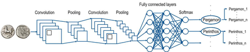
Creating an Additional Class Layer with Machine Learning to counter Overfitting in an Unbalanced Ancient Coin DatasetA significant contribution to the problem of unbalanced data in machine learning research in archaeologyRecommended by Alex Brandsen based on reviews by Simon Carrignon, Joel Santos and 1 anonymous reviewer
This paper [1] presents an innovative approach to address the prevalent challenge of unbalanced datasets in coin type recognition, shifting the focus from coin class type recognition to coin mint recognition. Despite this shift, the issue of unbalanced data persists. To mitigate this, the authors introduce a method to split larger classes into smaller ones, integrating them into an 'additional class layer'. Three distinct machine learning (ML) methodologies were employed to identify new possible classes, with one approach utilising unsupervised clustering alongside manual intervention, while the others leverage object detection, and Natural Language Processing (NLP) techniques. However, despite these efforts, overfitting remained a persistent issue, prompting the authors to explore alternative methods such as dataset improvement and Generative Adversarial Networks (GANs). The paper contributes significantly to the intersection of ML techniques and archaeology, particularly in addressing overfitting challenges. Furthermore, the authors' candid acknowledgment of the limitations of their approaches serves as a valuable resource for researchers encountering similar obstacles. This study stems from the D4N4 project, aimed at developing a machine learning-based coin recognition model for the extensive "Corpus Nummorum" dataset, comprising over 19,600 coin types and 49,000 coins from various ancient landscapes. Despite encountering challenges with overfitting due to the dataset's imbalance, the authors' exploration of multiple methodologies and transparent documentation of their limitations enriches the academic discourse and provides a foundation for future research in this field. Reference [1] Gampe, S. and Tolle, K. (2024). Creating an Additional Class Layer with Machine Learning to counter Overfitting in an Unbalanced Ancient Coin Dataset. Zenodo, 8298077, ver. 4 peer-reviewed and recommended by Peer Community in Archaeology. https://doi.org/10.5281/zenodo.8298077 | Creating an Additional Class Layer with Machine Learning to counter Overfitting in an Unbalanced Ancient Coin Dataset | Sebastian Gampe, Karsten Tolle | <p>We have implemented an approach based on Convolutional Neural Networks (CNN) for mint recognition for our Corpus Nummorum (CN) coin dataset as an alternative to coin type recognition, since we had too few instances for most of the types (classe... | | Computational archaeology | Alex Brandsen | 2023-08-29 16:26:41 | ||
14 May 2024

Supporting the analysis of a large coin hoard with AI-based methodsA demonstration of the use and finetuning of existing machine learning tools for analysing large complexes of coinsRecommended by Alex Brandsen based on reviews by 2 anonymous reviewers
The paper outlines the ClaReNet project's exploration of computer-based methods for classifying Celtic coin series, specifically focusing on a hoard from Jersey [1]. They collaborated with Jersey Heritage and numismatists, utilising a large dataset of coin images. The process involves stages such as pre-sorting, size-based sorting, class/type identification, and die studies. They employed IT methods, including object detection and unsupervised learning, followed by supervised learning for data refinement. Collaboration with numismatic experts ensured data quality. The study highlighted challenges in classifying coins, suggesting techniques like image matching alongside convolutional neural networks (CNNs). The results demonstrate the efficacy of semi-automatic processes in coin classification, emphasising the importance of human-computer collaboration for successful outcomes. Overall, this is a good paper, showing how we as archaeologists and numismatics can use existing tools and finetune them for our purposes; without the need for huge domain specific datasets. This research and related papers show how we can more effectively deal with the increasingly bigger data we deal with, saving time on the monotonous and labour intensive tasks, leaving us more time to deal with the big picture. An important strength of the work is the provided public software repository and the dataset. The paper is well written, and a number of images illustrate the methodology as well as the objects used. Reference [1] Deligio, C., Tolle, K., and Wigg-Wolf, D. (2024). Supporting the analysis of a large coin hoard with AI-based methods. Zenodo, 8301464, ver. 4 peer-reviewed and recommended by Peer Community in Archaeology. https://doi.org/10.5281/zenodo.8301464
| Supporting the analysis of a large coin hoard with AI-based methods | Chrisowalandis Deligio, Karsten Tolle, David Wigg-Wolf | <p>In the project "Classifications and Representations for Networks: From types and characteristics to linked open data for Celtic coinages" (ClaReNet) we had access to image data for one of the largest Celtic coin hoards ever found: Le Câtillon I... | | Computational archaeology | Alex Brandsen | 2023-08-30 15:31:16 | ||
02 May 2024
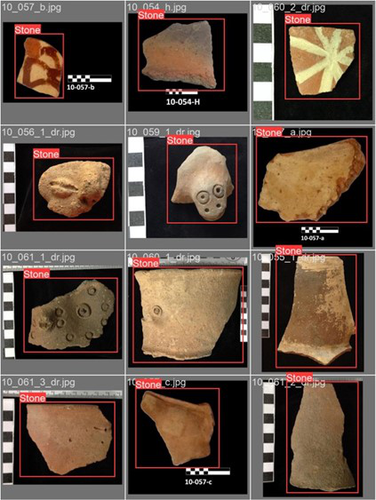
Machine Learning for UAV and Ground-Captured Imagery: Toward Standard PracticesA step forward in detecting small objects in UAV data for archaeological surveyingRecommended by Alex Brandsen based on reviews by 2 anonymous reviewers
In this paper [1], the authors describe how they apply machine learning with YOLOv5 to classify visual data, aiming to enhance understanding of archaeological phenomena before conducting destructive fieldwork. Despite challenges, the integration of machine learning with remote sensing technology was seen as transformative, enabling precise recording of areas of interest and assessment of environmental risk factors. The paper discusses successes, failures, and future directions in machine learning research, emphasising the need for standardisation and integration of streamlined methods. The application of machine learning techniques facilitates non-destructive analysis of material culture records, improving conservation efforts and offering insights into both past and contemporary phenomena. While the initial use of YOLOv5 showed potential for consistent detection of archaeological features, further refinement and dataset enlargement are deemed necessary for broader application in non-destructive archaeological surveying. The authors advocate for the integration of machine learning tools in archaeological research to save time, resources, and promote ethical digital recording practices. They highlight the importance of standardised methodologies to enhance credibility and reproducibility, aiming to contribute to the ongoing dialogue in computational archaeology. Overall, I think this paper is a good step forward in detecting small objects in UAV data, and contains useful information for similar studies. The aim towards greater reproducibility and standardisation is of course shared more widely in the machine learning community, and this study is a good example of how to approach this. References [1] Sharp, K., Christofis, B., Eslamiat, H., Nepal, U. and Osores Mendives, C. (2024). Machine Learning for UAV and Ground-Captured Imagery: Toward Standard Practices. Zenodo, 8307612, ver. 5 peer-reviewed and recommended by Peer Community in Archaeology. https://doi.org/10.5281/zenodo.8307612 | Machine Learning for UAV and Ground-Captured Imagery: Toward Standard Practices | Sharp Kayeleigh, Christofis Brooklyn, Eslamiat Hossein, Nepal Upesh, Osores Mendives Carlos | <p>Our collaborative work began in 2019 with the intent to overcome obstacles that had arisen from the inability to access curated artifact collections from remote locations. It was our specific aim to not only create digital twins of excavated ob... | | Ceramics, Computational archaeology, Remote sensing, South America | Alex Brandsen | 2023-09-01 09:56:18 | ||
02 Apr 2024
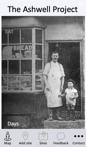
The Ashwell Project: Creating an Online Geospatial CommunityA nice project looking at under-represented demographicRecommended by Alexis Pantos based on reviews by Catriona Cooper and Steinar Kristensen
The paper by A. Lien-Talks [1] presents a small project looking at the use of crowd sourced data collection and particpatory GIS. In particular it looks at the potential of these tools in response to socially disruptive and isolating events such as the COVID-19 pandemic as well as the potential role of digitially mediated heritage initiatives in tackling some of the challenges of changing demographics and life styles. The types of technologies employed are relatively mature, the project identifies potential for such approaches to be used within the local-history/local community settings, though is also a reminer that depsite the much broader adoption of technology within all areas of society than even a few years ago many barriers still remain. While the the sample size and data collected in the project is relatively modest, the focus on empathy toward the intended audiences from the design process, as well as some of the qualitative feedback reported serve as a reminder that participatory, or crowd-sourced data collection initiatives in heritage can, and perhaps should place potential social benefit before data-acquisition of objectives. The project also presents a demographic that is not often represented within the literature and the publication and as such the publication of the article represents a meaningful contribution to ongoing discussions of the role heritage and digitally mediated community archaeology can play a role in developing our societies. References [1] Lien-Talks, A. (2024). The Ashwell Project: Creating an Online Geospatial Community. Zenodo, 8307882, ver. 4 peer-reviewed and recommended by Peer Community in Archaeology. https://doi.org/10.5281/zenodo.8307882 | The Ashwell Project: Creating an Online Geospatial Community | Alphaeus Lien-Talks | <p>Background:<br>As the world becomes increasingly digital, so too must the way in which archaeologists engage with the public. This was particularly important during the COVID-19 pandemic, and many outreach and engagement efforts began to move o... | | Computational archaeology | Alexis Pantos | 2023-09-01 11:25:54 | ||
26 Mar 2024
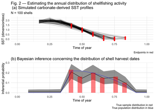
Inferring shellfishing seasonality from the isotopic composition of biogenic carbonate: A Bayesian approachMixture models and seasonal mobilityRecommended by Alfredo Cortell-Nicolau and Simon Carrignon based on reviews by Iza Romanowska and 1 anonymous reviewerThe paper by Brown & Lewis [1] presents an approach to measure seasonal mobility and subsistence practices. In order to do so, the paper proposes a Bayesian mixture model to estimate the annual distribution of shellfish harvesting activity. Following the recommendations of the two reviewers, the paper presents a clear and innovative method to assess seasonal mobility for prehistoric groups, although it could benefit from additional references regarding isotopic literature. While the adequacy of isotope analysis for estimating mobility patterns in Archaeology has been extensively proven by now, work on specific seasonal mobility is not that much abundant. However, this is a key issue, since seasonal mobility is one of the main social components defining the differences between groups both considering farming vs hunting and gathering or even among hunter-gatherer groups themselves. In this regard, the paper brings a valuable methodological resources that can be used for further research in this issue. One of its greatest values is the fact that it can quantify the uncertainty present in previous isotope studies in seasonal mobility. As stated by the authors, the model can still undergo several optimisation aspects, but as it stands, it is already providing a valuable asset regarding the quantification of uncertainy in the isotopic studies of seasonal mobility. Reference [1] Brown, J. and Lewis, G. (2024). Inferring shellfishing seasonality from the isotopic composition of biogenic carbonate: A Bayesian approach. Zenodo, 7949547, ver. 3 peer-reviewed and recommended by Peer Community in Archaeology. https://doi.org/10.5281/zenodo.7949547 | Inferring shellfishing seasonality from the isotopic composition of biogenic carbonate: A Bayesian approach | Jordan Brown and Gabriel Lewis | <p>The problem of accurately and reliably estimating the annual distribution of seasonally-varying human settlement and subsistence practices is a classic concern among archaeologists, which has only become more relevant with the increasing import... | | Archaeometry, Computational archaeology, Environmental archaeology, North America, Palaeontology, Paleoenvironment, Zooarchaeology | Alfredo Cortell-Nicolau | Iza Romanowska, Eduardo Herrera Malatesta, Alejandro Sierra Sainz-Aja, Sam Leggett, Christianne Fernee, Anonymous, Asier García-Escárzaga , Paul Szpak , Maria Elena Castiello , Jasmine Lundy , Tansy Branscombe | 2023-10-03 04:45:54 |


