Latest recommendations

| Id | Title * | Authors * | Abstract * | Picture * | Thematic fields * ▼ | Recommender | Reviewers | Submission date | |
|---|---|---|---|---|---|---|---|---|---|
20 Jul 2022
Faunal remains from the Upper Paleolithic site of Nahal Rahaf 2 in the southern Judean Desert, IsraelNew zooarchaeological data from the Upper Palaeolithic site of Nahal Rahaf 2, IsraelRecommended by Ruth Blasco based on reviews by Ana Belén Galán and Joana Gabucio based on reviews by Ana Belén Galán and Joana Gabucio
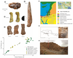
The Levantine Corridor is considered a crossing point to Eurasia and one of the main areas for detecting population flows (and their associated cultural and economic changes) during the Pleistocene. This area could have been closed during the most arid periods, giving rise to processes of population isolation between Africa and Eurasia and intermittent contact between Eurasian human communities [1,2]. Zooarchaeological studies of the early Upper Palaeolithic assemblages constitute an important source of knowledge about human subsistence, making them central to the debate on modern behaviour. The Early Upper Palaeolithic sequence in the Levant includes two cultural entities – the Early Ahmarian and the Levantine Aurignacian. This latter is dated to 39-33 ka and is considered a local adaptation of the European Aurignacian techno-complex. In this work, the authors present a zooarchaeological study of the Nahal Rahaf 2 (ca. 35 ka) archaeological site in the southern Judean Desert in Israel [3]. Zooarchaeological data from the early Upper Paleolithic desert regions of the southern Levant are not common due to preservation problems of non-lithic finds. In the case of Nahal Rahaf 2, recent excavation seasons brought to light a stratigraphical sequence composed of very well-preserved archaeological surfaces attributed to the 'Arkov-Divshon' cultural entity, which is associated with the Levantine Aurignacian. This study shows age-specific caprine (Capra cf. Capra ibex) hunting on prime adults and a generalized procurement of gazelles (Gazella cf. Gazella gazella), which seem to have been selectively transported to the site and processed for within-bone nutrients. An interesting point to note is that the proportion of goats increases along the stratigraphic sequence, which suggests to the authors a specialization in the economy over time that is inversely related to the occupational intensity of use of the site. It is also noteworthy that the materials represent a large sample compared to previous studies from the Upper Paleolithic of the Judean Desert and Negev. In summary, this manuscript contributes significantly to the study of both the palaeoenvironment and human subsistence strategies in the Upper Palaeolithic and provides another important reference point for evaluating human hunting adaptations in the arid regions of the southern Levant. References [1] Bermúdez de Castro, J.-L., Martinon-Torres, M. (2013). A new model for the evolution of the human pleistocene populations of Europe. Quaternary Int. 295, 102-112. https://doi.org/10.1016/j.quaint.2012.02.036 [2] Bar-Yosef, O., Belfer-Cohen, A. (2010). The Levantine Upper Palaeolithic and Epipalaeolithic. In Garcea, E.A.A. (Ed), South-Eastern Mediterranean Peoples Between 130,000 and 10,000 Years Ago. Oxbow Books, pp. 144-167. [3] Marom, N., Gnezdilov, D. L., Shafir, R., Barzilai, O. and Shemer, M. (2022). Faunal remains from the Upper Paleolithic site of Nahal Rahaf 2 in the southern Judean Desert, Israel. BioRxiv, 2022.05.17.492258, ver. 4 peer-reviewed and recommended by Peer community in Archaeology. https://www.biorxiv.org/content/10.1101/2022.05.17.492258v4 | Faunal remains from the Upper Paleolithic site of Nahal Rahaf 2 in the southern Judean Desert, Israel | Nimrod Marom, Dariya Lokshin Gnezdilov, Roee Shafir, Omry Barzilai, Maayan Shemer | <p>Nahal Rahaf 2 (NR2) is an Early Upper Paleolithic (ca. 35 kya) rock shelter in the southern Judean Desert in Israel. Two excavation seasons in 2019 and 2020 revealed a stratigraphical sequence composed of intact archaeological surfaces attribut... | | Upper Palaeolithic, Zooarchaeology | Ruth Blasco | Joana Gabucio | 2022-05-19 06:16:47 | |
02 Dec 2023
Research perspectives and their influence for typologiesComplexity and Purpose – A Pragmatic Approach to the Diversity of Archaeological Classificatory Practice and TypologyRecommended by Shumon Tobias Hussain, Felix Riede and Sébastien Plutniak based on reviews by Ulrich Veit, Martin Hinz, Artur Ribeiro and 1 anonymous reviewer
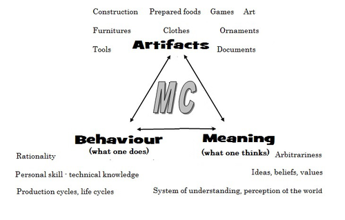
“Research perspectives and their influence for typologies” by E. Giannichedda (1) is a contribution to the upcoming volume on the role of typology and type-thinking in current archaeological theory and praxis edited by the recommenders. Taking a decidedly Italian perspective on classificatory practice grounded in what the author dubs the “history of material culture”, Giannichedda offers an inventory of six divergent but overall complementary modes of ordering archaeological material: i) chrono-typological and culture-historical, ii) techno-anthropological, iii) social, iv) socio-economic and v) cognitive. These various lenses broadly align with similarly labeled perspectives on the archaeological record more generally. According to the author, they lend themselves to different ways of identifying and using types in archaeological work. Importantly, Giannichedda reminds us that no ordering practice is a neutral act and typologies should not be devised for their own sake but because we have specific epistemic interests. Even though this view is certainly not shared by everyone involved in the broader debate on the purpose and goal of systematics, classification, typology or archaeological taxonomy (2–4), the paper emphatically defends the long-standing idea that ordering practices are not suitable to elucidate the structure and composition of reality but instead devise tools to answer certain questions or help investigate certain dimensions of complex past realities. This position considers typologies as conceptual prosthetics of knowing, a view that broadly resonates with what is referred to as epistemic instrumentalism in the philosophy of science (5, 6). Types and type-work should accordingly reflect well-defined means-end relationships. Based on the recognition of archaeology as part of an integrated “history of material culture” rooted in a blend of continental and Anglophone theories, Giannichedda argues that type-work should pay attention to relevant relations between various artefacts in a given historical context that help further historical understanding. Classificatory practice in archaeology – the ordering of artefactual materials according to properties – must thus proceed with the goal of multifaceted “historical reconstruction in mind”. It should serve this reconstruction, and not the other way around. By drawing on the example of a Medieval nunnery in the Piedmont region of northwestern Italy, Giannichedda explores how different goals of classification and typo-praxis (linked to i-v; see above) foreground different aspects, features, and relations of archaeological materials and as such allow to pinpoint and examine different constellations of archaeological objects. He argues that archaeological typo-praxis, for this reason, should almost never concern itself with isolated artefacts but should take into account broader historical assemblages of artefacts. This does not necessarily mean to pay equal attention to all available artefacts and materials, however. To the contrary, in many cases, it is necessary to recognize that some artefacts and some features are more important than others as anchors grouping materials and establishing relations with other objects. An example are so-called ‘barometer objects’ (7) or unique pieces which often have exceptional informational value but can easily be overlooked when only shared features are taken into consideration. As Giannichedda reminds us, considering all objects and properties equally is also a normative decision and does not render ordering less subjective. The archaeological analysis of types should therefore always be complemented by an examination of variants, even if some of these variants are idiosyncratic or even unique. A type, then, may be difficult to define universally. In total, “Research perspectives and their influence for typologies” emphasizes the need for “elastic” and “flexible” approaches to archaeological types and typologies in order to effectively respond to the manifold research interests cultivated by archaeologists as well as the many and complex past realities they face. Complexity is taken here to indicate that no single research perspective and associated mode of ordering can adequately capture the dimensionality and richness of these past realities and we can therefore only benefit from multiple co-existing ways of grouping and relating archaeological artefacts. Different logics of grouping may simply reveal different aspects of these realities. As such, Giannichedda’s proposal can be read as a formulation of the now classic pluralism thesis (8–11) – that only a plurality of ways of ordering and interrelating artefacts can unlock the full suite of relationships within historical assemblages archaeologists are interested in.
Bibliography 1. Giannichedda, E. (2023). Research perspectives and their influence for typologies, Zenodo, 7322855, ver. 9 peer-reviewed and recommended by Peer Community in Archaeology. https://doi.org/10.5281/zenodo.7322855 2. Dunnell, R. C. (2002). Systematics in Prehistory, Illustrated Edition (The Blackburn Press, 2002). 3. Reynolds, N. and Riede, F. (2019). House of cards: cultural taxonomy and the study of the European Upper Palaeolithic. Antiquity 93, 1350–1358. https://doi.org/10.15184/aqy.2019.49 4. Lyman, R. L. (2021). On the Importance of Systematics to Archaeological Research: the Covariation of Typological Diversity and Morphological Disparity. J Paleo Arch 4, 3. https://doi.org/10.1007/s41982-021-00077-6 5. Van Fraassen, B. C. (2002). The empirical stance (Yale University Press). 6. Stanford, P. K. (2006). Exceeding Our Grasp: Science, History, and the Problem of Unconceived Alternatives (Oxford University Press). https://doi.org/10.1093/0195174089.001.0001 7. Radohs, L. (2023). Urban elite culture: a methodological study of aristocracy and civic elites in sea-trading towns of the southwestern Baltic (12th-14th c.) (Böhlau). 8. Kellert, S. H., Longino, H. E. and Waters, C. K. (2006). Scientific pluralism (University of Minnesota Press). 9. Cat, J. (2012). Essay Review: Scientific Pluralism. Philosophy of Science 79, 317–325. https://doi.org/10.1086/664747 10. Chang, H. (2012). Is Water H2O?: Evidence, Realism and Pluralism (Springer Netherlands). https://doi.org/10.1007/978-94-007-3932-1 11. Wylie, A. (2015). “A plurality of pluralisms: Collaborative practice in archaeology” in Objectivity in Science, (Springer), pp. 189–210. https://doi.org/10.1007/978-3-319-14349-1_10
| Research perspectives and their influence for typologies | Enrico Giannichedda | <p>This contribution opens with a brief reflection on theoretical archaeology and practical material classification activities. Following this, the various questions that can be asked of artefacts to be classified will be briefly addressed. Questi... | | Theoretical archaeology | Shumon Tobias Hussain | 2022-11-10 20:14:52 | ||
10 Jun 2024

Hypercultural types: archaeological objects in fast times.The Postmodern Predicament of Type-Thinking in ArchaeologyRecommended by Shumon Tobias Hussain, Felix Riede and Sébastien Plutniak based on reviews by Gavin Lucas, Miguel John Versluys and Anna S. Beck
“Hypercultural types: archaeological objects in fast times” by A. Ribeiro (1) offers some timely, critical and creative reflections on the manifold struggles of and disappointments in type-thinking and typological approaches in recent archaeological scholarship. Ribeiro insightfully situates what has been identified as a “crisis” in archaeological typo-praxis in the historical conditions of postmodernity and late capitalism themselves. The author thereby attempts what he himself considers “quite hard”, namely “to understand the current Zeitgeist and how it affects how we think and do archaeology” (p. 4). This provides a sort of historical epistemology of the present which can of course only be preliminary and incomplete as it crystallizes, takes shape, and transforms as we write these lines, is available only in fragments and hints, and is generally difficult to talk about and describe as we (the author included) lack critical distance – present-day archaeologists and fellow academics are both enfolded in postmodernity and continue to contribute to its logics and trajectories. Ribeiro’s key argument is provocative as it is interesting: he contends that archaeologists’ difficulties of coming to terms with types and typologies – staple knowledge practices of the discipline ever since – are a symptom of the changing cultural matrix of our times. The diagnosis is multilayered and complex, and Ribeiro at times only scratches the surface of what may be at stake here as he openly admits himself. At the core of his proposal is a shift in attention away from classical questions of epistemological rank, which in archaeology have tended to orbit the contentious issue of the reality of types (see also 2). Instead of foregrounding the question of type-realities – whether types, once identified, can be meaningfully said to exist and to represent something significant in the world – archaeologists are urged to recognize that typo-praxis is culturally saturated in at least two profound ways. First, devising and mobilizing types and typologies is a cultural practice itself – it may indeed have long been a foundational ‘cultural technique’ (Kulturtechnik) (3) of archaeology as a disciplined community-venture of methodical knowledge production. Typo-centric understandings of the archaeological record are quite akin to definition-centric apprehensions of the same as in both cases order, discreteness, and one-to-one correspondence are considered overriding epistemic virtues and credible pointers to a subject-independent “reality”. As such, these practices have a location of their own and they may thus notably conflict with the particularities of alternate and ever-mutating phenomenal realities and historical conditions. Discreteness may for instance lose its paradigmatic status as a descriptor of worldly order, and this is precisely what Ribeiro argues to have happened in the wake of postmodern transformations, influentially said to have deeply reconfigured the relation between the local and the global, at times even superseding such distinctions altogether. When coupled to questions of reality, types, in a similar fashion as definitions, quickly become vehicles to affirm epistemic power and knowledge authority and so help certify certain kinds of realities while supressing others. This is the paradox of modernity: to insist on monolithic understandings of the world while professing radical difference. Second, and for Ribeiro more importantly, typo-praxis is not just subject to cultural variation and thus by implication is plural, it also always has its proper associated cultural milieu in which it exerts some sort of efficacy, i.e. enables action and insight. Ribeiro maintains that this sort of efficacy has become contentious under postmodern conditions and this is because culture, under the gaze of global consumerism, has lost much of its classical significance, and as “hyperculture” (4) developed new logics, significations, and material culture correspondences, essentially “flattening” the highly textured and differentiated world of modernity (p. 6). Some of these new configurations sharply violate the expectations of traditional views of culture. The postmodern situation has in this way effectively emerged as a resistant force proffering much caution and growing scepticism among archaeologists and other academics alike as received ideas about “types” and “cultures” do not seem to work anymore the same way as before. The credibility of different modes of typo-praxis, archaeological or not, in other words, may depend much more on the cultural ecology of lived experience and contemporary diagnosis than is often realized. With Ribeiro, we may say that culture concepts and type concepts are indeed co-constitutive, and what sort of types and typologies archaeologists can persuasively deploy thus also depends greatly on how we construct the link between culture and type, and how (well) we grapple with our own realities and the lessons we draw from them – yet another important reminder of how our own subjectivities figure in such foundational debates (see esp. 5). The crisis of typo-praxis in archaeology, then, is intricately linked to the crisis of modernity, broached by Ribeiro with the labels of postmodernity and late capitalism. Upon reflection, this is not surprising at all since Tylor’s (6) influential definition of culture for example, which is extensively referenced in the paper, was both reflective of and conducive to the project of modernity and its distinctive historical formations such as empire and colonialism. Ribeiro reminds us that questions of justification and credibility, be it in the domain of type-thinking or other epistemic contexts, can never be fully divorced from the contemporary situation, and archaeologists thus need to be vigilant observers of the present, too. Typo-praxis ultimately is motivated by and draws authority from what Foucault (7) has called épistémè, the totality of pertinent parameters forming the historical a priori of understanding or the guiding unconsciousness of subjectivity within a given epoch. The crisis of archaeological typo-praxis, in this view, signifies a calling into question of the historical a priori on which much traditional type-work in archaeology was premised. Archaeologists still have to come to terms with the implications and consequences of this assessment. “Hypercultural types: archaeological objects in fast times” offers a first poignant analysis of some of these challenges of postmodern archaeological type-thinking.
Bibliography 1. Ribeiro, A. (2024). Hypercultural types: archaeological objects in fast times. Zenodo, 10567441, ver. 3 peer-reviewed and recommended by Peer Community in Archaeology. https://doi.org/10.5281/zenodo.10567441 2. Hussain, S. T. (2024). The Loss of Typological Innocence: An Archaeology of Archaeological Typo-Praxis. Zenodo, 10567441. https://doi.org/10.5281/zenodo.10547264 3. Macho, T. (2013). Second-Order Animals: Cultural Techniques of Identity and Identification. Theory, Culture & Society 30, 30–47. https://doi.org/10.1177/0263276413499189 4. Han, B.-C. (2022). Hyperculture: culture and globalization (Polity Press). 5. Frank, A., Gleiser, M. and Thompson, E. (2024). The blind spot: why science cannot ignore human experience (The MIT Press). https://doi.org/10.7551/mitpress/13711.001.0001 6. E. B. Tylor, E. B. (1871). Primitive Culture: Researches Into the Development of Mythology, Philosophy, Religion, Art, and Custom (J. Murray). 7. Foucault, M. (2007). The order of things: an archaeology of the human sciences, Repr (Routledge). | Hypercultural types: archaeological objects in fast times. | Artur Ribeiro | <p>Although artifact typologies still play a big role in archaeology, they have certainly lost some repute in recent decades. More than just a collection of items with similar attributes, typologies are a reflection of cultural behaviour and pract... | | Theoretical archaeology | Shumon Tobias Hussain | 2024-01-25 13:40:08 | ||
28 May 2020

TIPZOO: a Touchscreen Interface for Palaeolithic Zooarchaeology. Towards making data entry and analysis easier, faster, and more reliableA new software to improve standardization and quality of data in zooarchaeologyRecommended by Florent Rivals based on reviews by Delphine Vettese and Argant Thierry
Standardization and quality of data collection are identified as challenges for the future in zooarchaeology [1]. These issues were already identified in the early 1970s when the International Council for Archaeozoology (ICAZ) recommended to “standardize measurements and data in publications”. In the recent years, there is strong recommendations by publishers and grant to follow the FAIR Principle i.e. to “improve the findability, accessibility, interoperability, and reuse of digital assets” [2]. As zooarchaeologists, we should make our methods more clear and replicable by other researchers to produce comparable datasets. In this paper the authors make a significant step in proposing a tool to replace traditional data recording softwares. The problems related to data recording are clearly identified and discussed. All the features offered by TIPZOO allow to standardize the data, to reduce the errors when entering the data, to save time with auto-filling entries. The coding system used in TIPZOO is based on variables taken from the most used and updated literature in zooarchaeology. Its connections with various R packages allow to directly export the data and to transform the raw data to produce summary tables, graphs and basic statistics. Finally, the advantage of this tool is that it can be improved, debugged, or implemented at any time. TIPZOO provides a standardized system to compile and share large and consistent datasets that will allow comparison among assemblages at a large scale, and for this reason, I have recommended the work for PCI Archaeology. References [1] Steele, T.E. (2015). The contributions of animal bones from archaeological sites: the past and future of zooarchaeology. J. Archaeol. Sci. 56, 168–176. doi: 10.1016/j.jas.2015.02.036 | TIPZOO: a Touchscreen Interface for Palaeolithic Zooarchaeology. Towards making data entry and analysis easier, faster, and more reliable | Emmanuel Discamps | <p>Zooarchaeological studies of fossil bone collections are often conducted using simple spreadsheet programs for data recording and analysis. After quickly summarizing the limitations of such an approach, we present a new software solution, TIPZO... | | Spatial analysis, Taphonomy, Zooarchaeology | Florent Rivals | 2020-04-16 13:27:00 | ||
02 Nov 2020
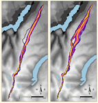
Probabilistic Modelling using Monte Carlo Simulation for Incorporating Uncertainty in Least Cost Path Results: a Roman Road Case StudyA probabilistic method for Least Cost Path calculation.Recommended by Otis Crandell based on reviews by Georges Abou Diwan and 1 anonymous reviewerThe paper entitled “Probabilistic Modelling using Monte Carlo Simulation for Incorporating Uncertainty in Least Cost Path Results: a Roman Road Case Study” [1] submitted by J. Lewis presents an innovative approach to applying Least Cost Path (LCP) analysis to incorporate uncertainty of the Digital Elevation Model used as the topographic surface on which the path is calculated. The proposition of using Monte Carlo simulations to produce numerous LCP, each with a slightly different DEM included in the error range of the model, allows one to strengthen the method by proposing a probabilistic LCP rather than a single and arbitrary one which does not take into account the uncertainty of the topographic reconstruction. This new method is integrated in the R package leastcostpath [2]. The author tests the method using a Roman road built along a ridge in Cumbria, England. The integration of the uncertainty of the DEM, thanks to Monte Carlo simulations, shows that two paths could have the same probability to be the real LCP. One of them is indeed the path that the Roman road took. In particular, it is one of two possibilities of LCP in the south to north direction. This new probabilistic method therefore strengthens the reconstruction of past pathways, while also allowing new hypotheses to be tested, and, in this case study, to suggest that the northern part of the Roman road’s location was selected to help the northward movements. [1] Lewis, J., 2020. Probabilistic Modelling using Monte Carlo Simulation for Incorporating Uncertainty in Least Cost Path Results: a Roman Road Case Study. SocArXiv, mxas2, ver 17 peer-reviewed and recommended by PCI Archaeology, 10.31235/osf.io/mxas2. [2] Lewis, J., 2020. leastcostpath: Modelling Pathways and Movement Potential Within a Landscape. R package. Version 1.7.4. | Probabilistic Modelling using Monte Carlo Simulation for Incorporating Uncertainty in Least Cost Path Results: a Roman Road Case Study | Joseph Lewis | <p>The movement of past peoples in the landscape has been studied extensively through the use of Least Cost Path (LCP) analysis. Although methodological issues of applying LCP analysis in Archaeology have frequently been discussed, the effect of v... | | Spatial analysis | Otis Crandell | Adam Green, Georges Abou Diwan | 2020-08-05 12:10:46 | |
12 Dec 2022
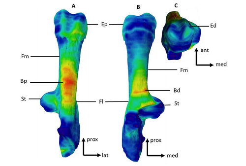
Can growth in captivity alter the calcaneal microanatomy of a wild ungulate?Mobility in pigs: A microanatomical perspectiveRecommended by Nimrod Marom based on reviews by Max Price and Ignacio A. Lazagabaster
Pig domestication and husbandry involved complex processes of introduction, introgression, and feralization that challenge our understanding of human/suid interactions in ancient times. This challenge is a constant stimulus for the development of novel methods and techniques to illuminate aspects of early pig husbandry, such as human-induced changes in mobility. Using geometric morphometrics, Harbers et al. (2020) have shown that the calcaneus records a plastic response to reduced mobility and hence to human management. In the present study, Cottereau et al. (2022) explore the possibility that a similar plastic response to different mobility regimes can be observed in the microanatomy of the calcaneus using CT scans. Their research utilizes a sample of calcanei obtained from Mesolithic specimens, and also from recent suids kept in natural habitat, large pen, and stall. Their results suggest that bone microanatomy is more affected by population differences than by mobility patterns, as illustrated by the similarity between Mesolitic boar calcanei and their difference from recent, free wild boar.
References Cottereau R, Ortiz K, Locatelli Y, Houssaye A, Cucchi T (2022), bioRxiv, 504790, ver. 5 peer-reviewed and recommended by Peer Community in Archaeology. https://doi.org/10.1101/2022.08.22.504790 Harbers H, Neaux D, Ortiz K, Blanc B, Laurens F, Baly I, Callou C, Schafberg R, Haruda A, Lecompte F, Casabianca F, Studer J, Renaud S, Cornette R, Locatelli Y, Vigne J-D, Herrel A, Cucchi T (2020) The mark of captivity: plastic responses in the ankle bone of a wild ungulate (Sus scrofa). Royal Society Open Science, 7, 192039. https://doi.org/10.1098/rsos.192039
| Can growth in captivity alter the calcaneal microanatomy of a wild ungulate? | Romain Cottereau, Katia Ortiz, Yann Locatelli, Alexandra Houssaye*, Thomas Cucchi* | <p style="text-align: justify;">Reduced mobility associated with captivity induce changes in biomechanical stress on the skeleton of domesticated animals. Due to bone plasticity, the morphology and the internal structure of the bones can respond t... | | Neolithic, Zooarchaeology | Nimrod Marom | 2022-08-26 20:29:01 | ||
28 Feb 2021
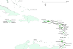
A database of lapidary artifacts in the Caribbean for the Ceramic AgeOpen data on beads, pendants, blanks from the Ceramic Age CaribbeanRecommended by Ben Marwick based on reviews by Clarissa Belardelli, Stefano Costa, Robert Bischoff and Li-Ying Wang
The paper 'A database of lapidary artifacts in the Caribbean for the Ceramic Age' by Queffelec et al. [1] presents a description of a dataset of nearly 5000 lapidary artefacts from over 100 sites. The data are dominated by beads and pendants, which are mostly made from Diorite, Turquoise, Carnelian, Amethyst, and Serpentine. The raw material data is especially valuable as many of these are not locally available on the island. This holds great potential for exchange network analysis. The data may be especially useful for investigating one of the fundamental questions of this region: whether the Cedrosan and Huecan are separate, little related developments, with different origins, or variants or a single tradition [2]. In addition to metric and technological details about the artefacts, the data include a variety of locational details, including coordinates, distance to coast, and altitude. This enables many opportunities for future spatial analysis and geostatistical modelling to understand human behaviours relating to ornament production, use, and discard. I recommend the authors make a minor revision to Table 1 (spatial coverage of the dataset) to make the column with the citations conform to the same citation style used in the rest of the text. I warmly commend the authors for making transparency and reproducibility a priority when preparing their manuscript. Their use of the R Markdown format for writing reproducible, dynamic documents [3] is highly impressive. This is an excellent example for others in the international archaeological science community to follow. The paper is especially useful for researchers who are new to R and R Markdown because of the elegant and accessible way the authors document their research here. [1] Queffelec, A., Fouéré, P. and Caverne, J.-B. 2021. A database of lapidary artifacts in the Caribbean for the Ceramic Age. SocArXiv, 7dq3b, ver. 4 Peer-reviewed and recommended by PCI Archaeology. https://doi.org/10.31235/osf.io/7dq3b [2] Reed, J. A. and Petersen, J. B. 2001. A comparison of Huecan and Cedrosan Saladoid ceramics at the Trants site, Montserrat. In Proceedings of the XVIIIth International Congress for Caribbean Archaeology (pp. 253-267). [3] Marwick, B. 2017. Computational Reproducibility in Archaeological Research: Basic Principles and a Case Study of Their Implementation. Journal of Archaeological Method and Theory 24, 424–450. https://doi.org/10.1007/s10816-015-9272-9 | A database of lapidary artifacts in the Caribbean for the Ceramic Age | Alain Queffelec, Pierrick Fouéré, Jean-Baptiste Caverne | <p>Lapidary artifacts show an impressive abundance and diversity during the Ceramic period in the Caribbean islands, especially at the beginning of this period. Most of the raw materials used in this production do not exist naturally on the island... | | Neolithic, North America, Raw materials, South America, Spatial analysis, Symbolic behaviours | Ben Marwick | 2020-11-13 23:52:34 | ||
26 Oct 2022
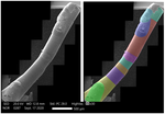
Technological analysis and experimental reproduction of the techniques of perforation of quartz beads from the Ceramic period in the AntillesUsing Cactus Thorns to Drill Quartz: A Proof of ConceptRecommended by Donatella Usai and Jonathan Hanna based on reviews by Viola Stefano, ? and 1 anonymous reviewer
Quartz adornments (beads, pendants, etc.) are frequent artifacts found in the Caribbean, particularly from Early Ceramic Age contexts (~500 BC-AD 700). As a form of specialization, these are sometimes seen as indicative of greater social complexity and craftsmanship during this time. Indeed, ethnographic analogy has purported that such stone adornments require enormous inputs of time and labor, as well as some technological sophistication with tools hard-enough to create the holes (e.g., metal or diamonds). However, given these limitations, one would expect unfinished beads to be a common artifact in the archaeological record. Yet, whereas unworked/raw materials are often found, beads with partial/unfinished perforations are not. References:
| Technological analysis and experimental reproduction of the techniques of perforation of quartz beads from the Ceramic period in the Antilles | Madeleine Raymond, Pierrick Fouéré, Ronan Ledevin, Yannick Lefrais and Alain Queffelec | <p style="text-align: justify;">Personal ornaments are a very specific kind of material production in human societies and are particularly valuable artifacts for the archaeologist seeking to understand past societies. In the Caribbean, Early Ceram... | | Lithic technology, Neolithic, South America, Symbolic behaviours, Traceology | Donatella Usai | 2022-09-06 14:01:51 | ||
12 Feb 2024
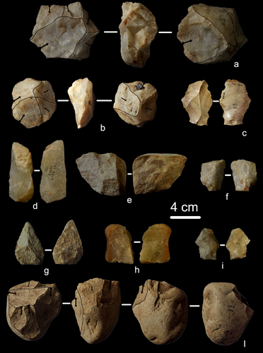
First evidence of a Palaeolithic occupation of the Po plain in Piedmont: the case of Trino (north-western Italy)Not Simply the Surface: Manifesting Meaning in What Lies Above.Recommended by Marcel Kornfeld based on reviews by Lawrence Todd, Jason LaBelle and 2 anonymous reviewersThe archaeological record comes in many forms. Some, such as buried sites from volcanic eruptions or other abrupt sedimentary phenomena are perhaps the only ones that leave relatively clean snapshots of moments in the past. And even in those cases time is compressed. Much, if not all other archaeological record is a messy affair. Things, whatever those things may be, artifacts or construction works (i.e., features), moved, modified, destroyed, warped and in a myriad of ways modified from their behavioral contexts. Do we at some point say the record is worthless? Not worth the effort or continuing investigation. Perhaps sometimes this may be justified, but as Daffara and colleagues show, heavily impacted archaeological remains can give us clues and important information about the past. Thoughtful and careful prehistorians can make significant contributions from what appear to be poor archaeological records. In the case of Daffara and colleagues, a number of important theoretical cross-sections can be recognized. For a long time surface archaeology was thought of simply as a way of getting a preliminary peak at the subsurface. From some of the earliest professional archaeologists (e.g., Kidder 1924, 1931; Nelson 1916) to the New Archaeologists of the 1960s, the link between the surface and subsurface was only improved in precision and systematization (Binford et al. 1970). However, at Hatchery West Binford and colleagues not only showed that surface material can be used more reliably to get at the subsurface, but that substantive behavioral inferences can be made with the archaeological record visible on the surface. Much more important are the behavioral implications drawn from surface material. I am not sure we can cite the first attempts at interpreting prehistory from the surface manifestations of the archaeological record, but a flurry of such approaches proliferated in the 1970s and beyond (Dunnell and Dancey 1983; Ebert 1992; Foley 1981). Off-site archaeology, non-site archaeology, later morphing into landscape archaeology all deal strictly with surface archaeological record to aid in understanding the past. With the current paper, Daffara and colleagues (2024) are clearly in this camp. Although still not widely accepted, it is clear that some behaviors (parts of systems) can only be approached from surface archaeological record. It is very unlikely that a future archaeologist will be able to excavate an entire human social/cultural system; people moving from season to season, creating multiple long and short term camps, travelling, procuring resources, etc. To excavate an entire system one would need to excavate 20,000 km2 or some similarly impossible task. Even if it was physically possible to excavate such an enormous area, it is very likely that some of contextual elements of any such system will be surface manifestations. Without belaboring the point, surface archaeological record yields data like any other archaeological record. We must contextual the archaeological artifacts or features weather they come from surface or below. Daffara and colleagues show us that we can learn about deep prehistory of northern Italy, with collections that were unsystematically collected, biased by agricultural as well as other land deformations agents. They carefully describe the regional prehistory as we know it, in particular specific well documented sites and assemblages as a means of applying such knowledge to less well controlled or uncontrolled collections.
References Binford, L., Binford, R. S. R., Whallon, R. and Hardin, M. A. (1970). Archaeology of Hatchery West. Memoirs of the Society for American Archaeology, No. 24, Washington D.C. Daffara, S., Giraudi, C., Berruti, G. L. F., Caracausi, S. and Garanzini, F. (2024). First evidence of a Palaeolithic frequentation of the Po plain in Piedmont: the case of Trino (north-western Italy), OSF Preprints, pz4uf, ver. 6 peer-reviewed and recommended by Peer Community in Archaeology. https://doi.org/10.31219/osf.io/pz4uf Dunnell, R. C. and Dancey, W. S. (1983). The siteless survey: a regional scale data collection strategy. In Advances in Archaeological Method and Theory, vol. 6, edited by Michael B. Schiffer, pp. 267-287. Academic Press, New York. Ebert, J. I. (1992). Distributional Archaeology. University of New Mexico Press, Albuquerque. Foley, R. A. (1981). Off site archaeology and human adaptation in eastern Africa: An analysis of regional artefact density in the Amboseli, Southern Kenya. British Archaeological Reports International Series 97. Cambridge Monographs in African Archaeology 3. Oxford England. Kidder, A. V. (1924). An Introduction to the Study of Southwestern Archaeology, With a Preliminary Account of the Excavations at Pecos. Papers of the Southwestern Expedition, Phillips Academy, no. 1. New Haven, Connecticut. Kidder, A. V. (1931). The Pottery of Pecos, vol. 1. Papers of the Southwestern Expedition, Phillips Academy. New Haven, Connecticut. Nelson, N. (1916). Chronology of the Tano Ruins, New Mexico. American Anthropologist 18(2):159-180. | First evidence of a Palaeolithic occupation of the Po plain in Piedmont: the case of Trino (north-western Italy) | Sara Daffara, Carlo Giraudi, Gabriele L.F. Berruti, Sandro Caracausi, Francesca Garanzini | <p>The Trino hill is an isolated relief located in north-western Italy, close to Trino municipality. The hill was subject of multidisciplinary studies during the 1970s, when, because of quarrying and agricultural activities, five concentrations of... | | Lithic technology, Middle Palaeolithic | Marcel Kornfeld | 2023-10-04 16:58:19 | ||
03 Feb 2024
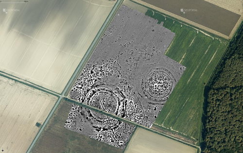
Digital surface models of crops used in archaeological feature detection – a case study of Late Neolithic site Tomašanci-Dubrava in Eastern CroatiaWhat lies on top lies also beneath? Connecting crop surface modelling to buried archaeology mapping.Recommended by Markos Katsianis based on reviews by Ian Moffat and Geert Verhoeven
This paper (Sosic et al. 2024) explores the Neolithic landscape of the Sopot culture in Đakovština, Eastern Slavonija, revealing a network of settlements through a multi-faceted approach that combines aerial archaeology, magnetometry, excavation, and field survey. This strategy facilitates scalable research tailored to the particularities of each site and allows for improved representations of buried archaeology with minimal intrusion. Using the site of Tomašanci-Dubrava as an example of the overall approach, the study further explores the use of drone imagery for 3D surface modeling, revealing a consistent correlation between crop surface elevation during full plant growth and ground terrain after ploughing, attributed to subsurface archaeological features. Results are correlated with magnetic survey and test-pitting data to validate the micro-topography and clarify the relationship between different subsurface structures. The results obtained are presented in a comprehensive way, including their source data, and are contextualized in relation to conventional cropmark detection approaches and expectations. I found this aspect very interesting, since the crop surface and terrain models contradict typical or textbook examples of cropmark detection, where the vegetation is projected to appear higher in ditches and lower in areas with buried archaeology (Renfrew & Bahn 2016, 82). Regardless, the findings suggest the potential for broader applications of crop surface or canopy height modelling in landscape wide surveys, utilizing ALS data or aerial photographs. It seems then that the authors make a valid argument for a layered approach in landscape-based site detection, where aerial imagery can be used to accurately map the topography of areas of interest, which can then be further examined at site scale using more demanding methods, such as geophysical survey and excavation. This scalability enhances the research's relevance in broader archaeological and geographical contexts and renders it a useful example in site detection and landscape-scale mapping. References Renfrew, C. and Bahn, P. (2016). Archaeology: theories, methods and practice. Thames and Hudson. Sosic Klindzic, R., Vuković, M., Kalafatić, H. and Šiljeg, B. (2024). Digital surface models of crops used in archaeological feature detection – a case study of Late Neolithic site Tomašanci-Dubrava in Eastern Croatia, Zenodo, 7970703, ver. 4 peer-reviewed and recommended by Peer Community in Archaeology. https://doi.org/10.5281/zenodo.7970703 | Digital surface models of crops used in archaeological feature detection – a case study of Late Neolithic site Tomašanci-Dubrava in Eastern Croatia | Sosic Klindzic Rajna; Vuković Miroslav; Kalafatić Hrvoje; Šiljeg Bartul | <p>This paper presents the results of a study on the neolithic landscape of the Sopot culture in the area of Đakovština in Eastern Slavonija. A vast network of settlements was uncovered using aerial archaeology, which was further confirmed and chr... | | Landscape archaeology, Neolithic, Remote sensing, Spatial analysis | Markos Katsianis | 2023-09-01 12:57:04 |


